![[Cover]](images/cover.jpg)
Title: The Anglo-Egyptian Sudan: a compendium prepared by officers of the Sudan government, Vol. 2 (of 2)
Editor: Edward Gleichen
Release date: October 15, 2024 [eBook #74585]
Language: English
Original publication: London: His Majesty's Stationery Office
Credits: Galo Flordelis (This file was produced from images generously made available by The Internet Archive/University of Pretoria)
Large-size versions of illustrations are available by clicking on them.
[All rights reserved.
A COMPENDIUM
PREPARED BY OFFICERS OF THE
SUDAN GOVERNMENT.
EDITED
BY
LIEUT.-COLONEL COUNT GLEICHEN, C.V.O., C.M.G.,
D.S.O.
(Late Director of Intelligence, Sudan
Government and Egyptian Army, and Sudan Agent, Cairo.)
Volume
II.
(ROUTES.)
LONDON:
PRINTED FOR HIS MAJESTY’S STATIONERY OFFICE,
BY HARRISON AND SONS, ST. MARTIN’S
LANE,
PRINTERS IN ORDINARY TO HIS MAJESTY.
And to be purchased, either
directly or through any Bookseller, from
WYMAN AND SONS, Ltd., Fetter Lane E.C.;
or
OLIVER & BOYD, Edinburgh; or
E. PONSONBY, 116, Grafton Street,
Dublin.
1905.
Price Seven Shillings and Sixpence.
(Wt. 8207 1000 9 | 05—H & S 3874)
![[Decoration]](images/decor.png)
The Routes in this Volume have been arranged according to the Chapters in Vol. I.
Additional matter is given in the shape of an Appendix, describing the main Routes leading out of the Sudan.
Almost the whole Volume has been edited by Captain H. H. S. Morant (Assistant Director of Intelligence), to whom my best thanks are due; Captain W. Lloyd is chiefly responsible for the excellent Routes in Kordofan.
Intermediate places where water is to be found (except those obviously on a river) are given in italics.
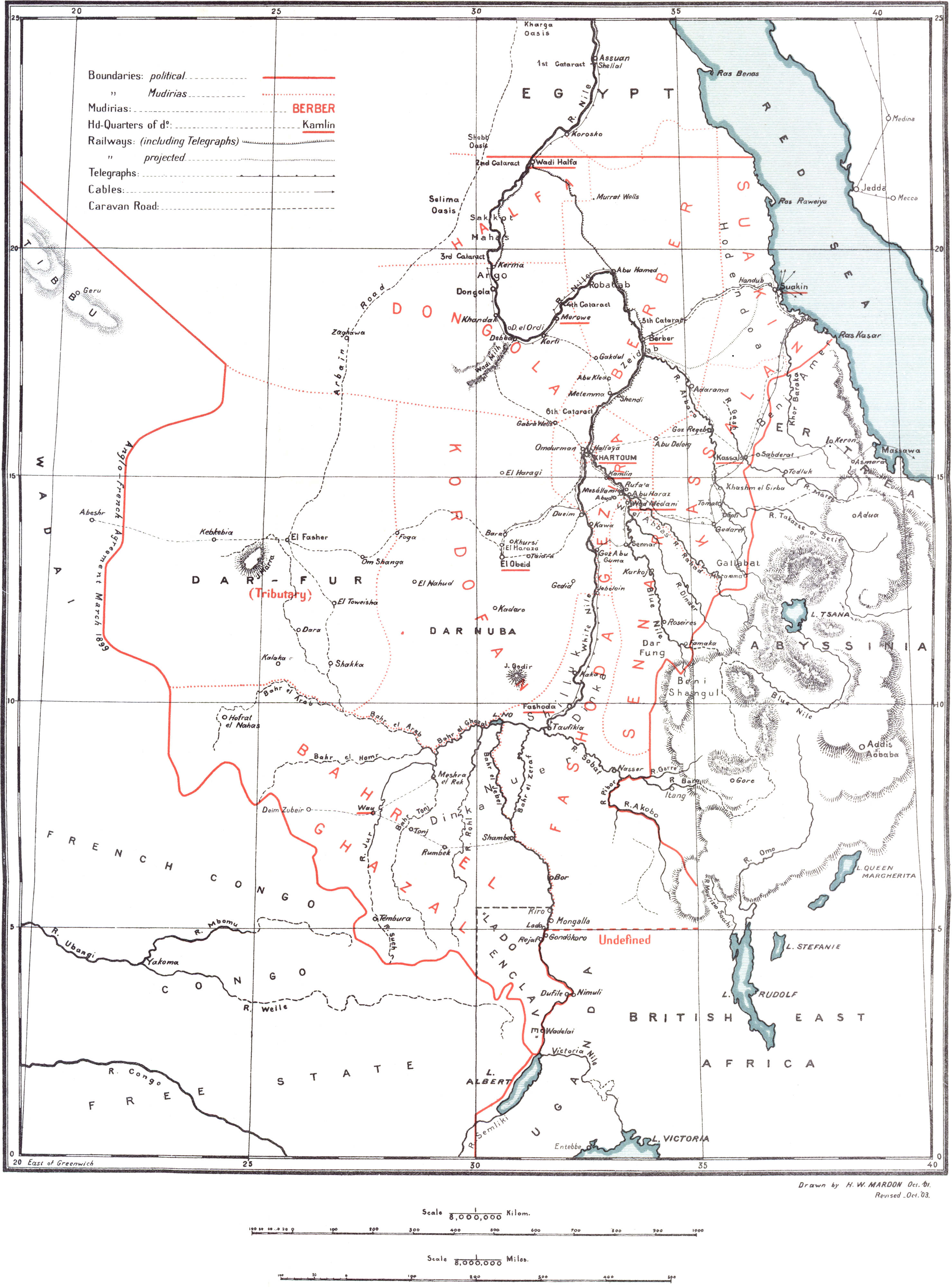
[It being impossible to provide a map showing even all the terminal places mentioned, intending travellers are referred to the map at the end of Vol. I, and to the Sudan Ordnance Survey Maps (scale, 1:250,000), a list of which is given in Vol. I, p. 349.]
A certain number of copies of each Chapter in this Volume have been printed and bound separately in strong paper covers for practical use when travelling. Application in Egypt should be made to the Director of Intelligence, Egyptian War Office, Cairo, or to any Bookseller in Great Britain, of whom copies may be obtained, price One Shilling each.
G.
Berlin, 2nd April, 1905.
VOL. II. (PART
III.)
(ROUTES.)
| CHAPTERS I and II. | ||||
| Nil. | ||||
| CHAPTER III. | ||||
| NORTH-EASTERN SUDAN. | ||||
| PAGE | ||||
| No. | 1. — | No. 6 Station to Deraheib. (Talbot) | 1 | |
| „ | 2. — | Suakin to Berber — | (α) Northerly route. (Sparkes) | 5 |
| (β) Southerly „ „ | 9 | |||
| „ | 3. — | Berber to Kassala. (Various) | 12 | |
| „ | 4. — | Suakin to Tokar. (Various) | 14 | |
| „ | 5. — | Trinkitat to Tokar. (Bower) | 15 | |
| „ | 6. — | Suakin to Erkowit — | (α) viâ Tamaneb and K. Arab. (Powell) | 16 |
| (β) viâ Kolkalai Pass. (Powell) | 16 | |||
| „ | 7. — | Erkowit to Sinkat — | (α) viâ Baramil Plains. (Powell) | 17 |
| (β) viâ K. Gebet. (Powell) | 17 | |||
| „ | 8. — | Kassala to Suakin, viâ Filik and Maman. (Mitford) | 18 | |
| „ | 9. — | Tokar to Kassala, viâ K. Baraka. (Various) | 22 | |
| „ | 10. — | Kassala to Maman direct. (Morant) | 26 | |
| „ | 11. — | Adarama to Bir Oshi (K. Langeb). (Kenrick) | 27 | |
| „ | 12. — | El Getite to Adarama. (Kenrick) | 29 | |
| „ | 13. — | Umbrega to Sofi. (Morant) | 30 | |
| N.B.—Other routes which apply to this chapter are:— | ||||
| No. | 123. — | Aswan to Deraheib. (Appendix) | 195 | |
| „ | 19. — | Gedaref to Kassala. (Chap. IV) | 41 | |
| „ | 14. — | Khartoum N. to Kassala. (Chap. IV) | 32 | |
| „ | 124. — | Kassala to Massaua. (Appendix) | 196 | |
| „ | 125. — | Takarashorit to Umbrega. (Appendix) | 200 | |
| CHAPTER IV. | ||||
| EASTERN SUDAN. | ||||
| No. | 14. — | Khartoum N. to Kassala, viâ Geili, Rera and Asubri. (Talbot, Boulnois and Morant) | 32 | |
| „ | 15. — | Goz Regeb to Shendi, viâ Abu Deleig. (Boulnois) | 36 | |
| „ | 16. — | El Damer to Fasher. (Bulkeley Johnson) | 36 | |
| „ | 17. — | Khartoum N. to Abu Deleig. (Native information) | 39 | |
| „ | 18. — | Rufaa to Geili. (Talbot) | 40 | |
| „ | 19. — | Gedaref to Kassala. (Mitford and Morant) | 41 | |
| „ | 20. — | „ Gallabat. (Collinson and Morant) | 43 | |
| „ | 21. — | Abu Haraz to Gedaref. (Mitford) | 45 | |
| „ | 22. — | Gedaref, viâ Hawata, to Abu Haraz. (Bulkeley Johnson) | 47 | |
| „ | 23. — | Sofi viâ Abu Gulud to Seraf Said. (Smith) | 48 | |
| [vi]„ | 24. — | Famaka to Abu Ramla. (Gwynn) | 49 | |
| „ | 25. — | Karkoj to Hawata. (Bonham Carter) | 50 | |
| „ | 26. — | Roseires to Abu Shaneina. (Gwynn) | 50 | |
| „ | 27. — | Senga, viâ Durraba, to Um El Rug. (Amery) | 51 | |
| „ | 28. — | Mouth of Khor Gelagu (Dinder) to Gallabat. (Amery) | 52 | |
| „ | 29. — | Gallabat to Wad Medani, viâ R. Rahad. (Lewin) | 53 | |
| „ | 30. — | Itinerary of Blue Nile. (Amery) | 57 | |
| N.B.—Other routes which apply to this chapter are:— | ||||
| No. | 126. — | Gallabat to Chelga. (Appendix) | 202 | |
| „ | 127. — | Lake Tsana (Goja) to Gandoa. (Appendix) | 204 | |
| „ | 128. — | Addis Abbaba to Gallabat. (Appendix) | 206 | |
| „ | 130. — | Roseires to Dunkur. (Appendix) | 215 | |
| „ | 131. — | Dunkur to Gallabat. (Appendix) | 217 | |
| CHAPTER V. | ||||
| CENTRAL SUDAN. | ||||
| No. | 31. — | Khartoum to Wad Medani, Sennar, Senga and Karkoj (L. B. Blue Nile). (Compiled) | 61 | |
| „ | 32. — | Khartoum to Goz Abu Guma and Jebelein, viâ R. B. White Nile. (Conolly, Boulnois) | 63 | |
| „ | 33. — | „ Gule, viâ Managil and Segadi. (Morant) | 66 | |
| „ | 34. — | Managil to Sennar. (Smyth) | 70 | |
| „ | 35. — | Keili, viâ Gule, to Senga. (Gorringe) | 70 | |
| „ | 36. — | Senga to Jerok, viâ K. Ofat. (Roberts) | 71 | |
| „ | 37. — | Roseires to Keili, viâ Gule. (Smith) | 73 | |
| „ | 38. — | Fazogli to Gezan. (Jackson) | 73 | |
| „ | 39. — | Gezan to Kurmuk. (Gwynn) | 75 | |
| „ | 40. — | Gule to Renk. (Morant) | 75 | |
| „ | 41. — | Jebelein to Renk. (Wilson) | 76 | |
| „ | 42. — | Renk to Kaka Old Wood Station. (Morant) | 77 | |
| „ | 43. — | „ Kodok (R. B.) partly along Telegraph line. (Wilson) | 79 | |
| „ | 44. — | J. Ahmed Agha to Awitong and Kash-Kash. (Wilson) | 82 | |
| „ | 45. — | Itinerary up Khor Adar. (Wilson) | 83 | |
| „ | 46. — | J. Jerok to Wad Deluka (52 miles S.E. of Melut). (Smith) | 84 | |
| „ | 47. — | Uryong (Sobat) to opposite Kodok. (Gwynn) | 85 | |
| N.B.—Other routes which apply to this chapter are:— | ||||
| No. | 133. — | Kirin to Kodok. (Appendix) | 222 | |
| „ | 132. — | Fazogli to Kirin. (Appendix) | 218 | |
| „ | 129. — | Addis Abbaba to Famaka. (Appendix) | 210 | |
| CHAPTER VI. | ||||
| SOUTH-EASTERN SUDAN. | ||||
| No. | 48. — | Nasser to Uryong. (Gwynn) | 87 | |
| „ | 49. — | Gokjak to Keik (Khor Filus). (Wilson) | 88 | |
| „ | 50. — | Itinerary up the Bahr El Zeraf. (Stanton) | 90 | |
| N.B.—Other routes which apply to this chapter are:— | ||||
| No. | 47. — | Uryong to opposite Kodok. (Chapter V) | 85 | |
| „ | 134. — | K. Bosuk, viâ K. Eine, to Goha. (Appendix) | 225 | |
| „ | 135. — | Goha, viâ K. Barsu, to Bosuk. (Appendix) | 225 | |
| „ | 136. — | Camp (K. Bosuk) to Asosa. (Appendix) | 226 | |
| „ | 137. — | Asosa to K. Bosuk, viâ K. Surgalla. (Appendix) | 227 | |
| „ | 138. — | Gore to Abwong. (Appendix) | 227 | |
| [vii]CHAPTER VII. | ||||
| BAHR EL GHAZAL. | ||||
| No. | 51. — | Meshra el Rek to Tonj. (Lloyd) | 93 | |
| „ | 52. — | Wau to Meshra el Rek. (Lloyd) | 94 | |
| „ | 53. — | Tonj Post to Wau. (Lloyd) | 95 | |
| „ | 54. — | Tonj Post to Rikta’s Village. (Lloyd) | 97 | |
| „ | 55. — | Wau to Tembura. (Bethel) | 99 | |
| „ | 56. — | Wau to Deim Zubeir. (Boulnois and Sparkes) | 100 | |
| „ | 57. — | Chak Chak to Deim Zubeir. (Fell) | 101 | |
| „ | 58. — | Deim Zubeir to Kossinga. (Boulnois) | 102 | |
| „ | 59. — | Kossinga to Wau. (Boulnois) | 103 | |
| „ | 60. — | „ Hofrat el Nahas. (Sparkes) | 104 | |
| „ | 61. — | Ragaa to Deim Zubeir. (Sparkes) | 105 | |
| „ | 62. — | Kojali to Tonj. (Sparkes) | 106 | |
| „ | 63. — | Tonj to Rumbek. (Armstrong) | 107 | |
| „ | 64. — | Rumbek to Shambe. (Armstrong) | 108 | |
| „ | 65. — | Rumbek to Darago’s and M’volo. (Wood) | 109 | |
| „ | 66. — | M’volo to Kiro. (Sparkes) | 109 | |
| „ | 67. — | Rumbek to Awodi. (Armstrong) | 111 | |
| „ | 68. — | „ Mangi’s. (Boardman) | 113 | |
| N.B.—Another route which applies to this chapter is:— | ||||
| No. | 101. — | El Obeid to Dar El Jange. (Chapter VIII) | 151 | |
| CHAPTER VIII. | ||||
| KORDOFAN. | ||||
| No. | 69. — | Sheikh Sadik to Homra. (Various) | 117 | |
| „ | 70. — | El Dueim to Homra. (Various) | 117 | |
| „ | 71. — | Homra to El Obeid, viâ Bara. (Various) | 118 | |
| „ | 72. — | El Dueim to Obeid, viâ Hashaba. (Lloyd and More) | 119 | |
| „ | 73. — | Gedid to El Dueim, viâ Um Deisis. (Lloyd and Talbot) | 120 | |
| „ | 74. — | Shat Wells to El Obeid, viâ J. Kon. (Talbot and Lloyd) | 120 | |
| „ | 75. — | Shawal to Gedid, Dar El Ahamda and Tagale. (Morant) | 122 | |
| „ | 76. — | Goz Abu Guma to Dar El Ahamda. (Morant) | 124 | |
| „ | 77. — | „ „ El Obeid, viâ Sherkeila and Rahad. (Leveson) | 125 | |
| „ | 78. — | Gedid to El Rahad. (Lloyd) | 126 | |
| „ | 79. — | Kaka to opposite Jebelein. (Wilson) | 127 | |
| „ | 80. — | Omdurman to El Safia Wells. (Smyth) | 129 | |
| „ | 81. — | Debba to El Obeid, viâ Safia. (Currie) | 130 | |
| „ | 82. — | Shegeig to El Showa, viâ Kagmar. (Lloyd) | 131 | |
| „ | 83. — | Bara to Kagmar. (Lloyd) | 132 | |
| „ | 84. — | El Obeid to Foga, viâ Masrub. (Lloyd) | 133 | |
| „ | 85. — | „ „ viâ Gleit, etc. (Carter) | 134 | |
| „ | 86. — | Abu Agaga to Bara. (O’Connell) | 135 | |
| „ | 87. — | Foga to Kaja (Bir Soderi). (Mahon) | 136 | |
| „ | 88. — | Nahud to El Fasher. (Carter) | 137 | |
| „ | 89. — | „ Bur Islam. (Townsend) | 137 | |
| „ | 90. — | „ Foga. (Lloyd and Wilkinson) | 138 | |
| „ | 91. — | Foga to Um Badr. (Wilkinson) | 139 | |
| „ | 92. — | Bara to Foga. (O’Connell) | 140 | |
| „ | 93. — | Nahud to El Eddaiya and Muglad. (Mahon) | 141 | |
| „ | 94. — | Foga to El Eddaiya, viâ Kaja Serrug. (Carter) | 142 | |
| „ | 95. — | El Obeid to Nahud (direct). (Meyricke) | 143 | |
| „ | 96. — | „ „ viâ Abu Zabbat. (Lloyd and Townsend) | 144 | |
| „ | 97. — | „ El Eddaiya, viâ Sungikai. (Lloyd and Townsend) | 145 | |
| „ | 98. — | „ Keraia (J. Tagale), viâ J. Daier. (Various) | 146 | |
| „ | 99. — | Keraia to Rashad and Gedir. (Various) | 148 | |
| „ | 100. — | Kaka to Gedir. (Mahon) | 148 | |
| „ | 101. — | El Obeid to Dar El Jange. (Wilkinson) | 151 | |
| „ | 102. — | River Kir to Fauwel. (Wilkinson) | 156 | |
| „ | 103. — | El Obeid to Sungikai, viâ El Atshan. (Lyall) | 157 | |
| „ | 104. — | Dilling to El Obeid, viâ Sungikai, etc. (Lyall) | 157 | |
| „ | 105. — | Routes in Dar Nuba. (Leveson) | 158 | |
| [viii]CHAPTER IX. | ||||
| NORTH-WESTERN SUDAN. | ||||
| No. | 106. — | Selima to Nile, opposite Kosha. (Hodgson) | 167 | |
| „ | 107. — | Dongola to Lagia El Kebir. (Hodgson) | 167 | |
| „ | 108. — | „ Bir Sultan. (Hodgson) | 169 | |
| „ | 109. — | Debba to El Obeid. (Compiled) | 171 | |
| „ | 110. — | „ Omdurman. (Ravenscroft) | 172 | |
| „ | 111. — | „ „ viâ Elai. (Compiled) | 174 | |
| „ | 112. — | Ambugol or Korti to Metemma. (Compiled) | 174 | |
| „ | 113. — | Korti to Bayuda and Sedeiri. (Bunbury and Sudley) | 178 | |
| „ | 114. — | Merowe to Jakdul. (Talbot) | 179 | |
| „ | 115. — | „ Berber. (Smyth and Friend) | 181 | |
| „ | 116. — | Sani to El Zuma, viâ Jura. (Henry) | 181 | |
| „ | 117. — | Jura to Kirbekan. (Henry) | 182 | |
| „ | 118. — | Omdurman to Gabra. (Talbot) | 183 | |
| „ | 119. — | Gabra to Korti. (Talbot) | 184 | |
| „ | 120. — | Korti to Bayuda Wells. (Talbot) | 186 | |
| „ | 121. — | Bayuda Wells to Tangasi. (Talbot) | 187 | |
| N.B.—Other routes which apply to this chapter are:— | ||||
| No. | 81. — | Debba to El Obeid, viâ Safia. (Chapter VIII) | 130 | |
| „ | 122. — | Arbain Road. (Appendix) | 189 | |
| APPENDIX. | ||||
| ROUTES PARTLY OUTSIDE THE SUDAN. | ||||
| No. | 122. — | The Arbain Road. (Various) | 189 | |
| „ | 123. — | Aswan to Deraheib. (Bramly) | 195 | |
| „ | 124. — | Kassala to Massaua. (Morant) | 196 | |
| „ | 125. — | Takarashorit (K. Gash) to Umbrega (Setit). (Morant) | 200 | |
| „ | 126. — | Gallabat to Chelga. (Parker) | 202 | |
| „ | 127. — | Lake Tsana (Goja) to Gandoa. (Parker) | 204 | |
| „ | 128. — | Addis Abbaba, viâ Gojjam and L. Tsana, to Gallabat. (Baird) | 206 | |
| „ | 129. — | „ to Famaka. (Gwynn) | 210 | |
| „ | 130. — | Roseires to Abu Ramla and Dunkur. (Gwynn) | 215 | |
| „ | 131. — | Dunkur to Gallabat. (Gwynn) | 217 | |
| „ | 132. — | Fazogli to Kirin. (Jackson) | 218 | |
| „ | 133. — | Kirin to Kodok. (Gwynn) | 222 | |
| „ | 134. — | K. Bosuk, viâ K. Eine, to Goha. (Smith) | 225 | |
| „ | 135. — | Goha, viâ K. Barsu, to Bosuk. (Smith) | 225 | |
| „ | 136. — | Camp (K. Bosuk) to Asosa. (Smith) | 226 | |
| „ | 137. — | Asosa to K. Bosuk, viâ Surgalla. (Smith) | 227 | |
| „ | 138. — | Gore to Abwong. (Wilson) | 227 | |
| „ | 139. — | Gondokoro to Uganda. (Dugmore) | 231 | |
| „ | 140. — | Roads in the Lado Enclave. (Various) | 236 | |
[1]Part III.
ROUTES.
CHAPTERS I. and II.
(Nil.)
(NORTH-EASTERN SUDAN.)
By Colonel Hon. M. G. Talbot, R.E., December, 1902.
General.The road described below is only one of several that might have been taken, but I believe it is perhaps the most direct. The portions between No. 6 and Murrat, and along the Wadi Alagi must be common to all routes.
Nature of road.There are no gradients on the road sufficiently steep to form a serious obstacle to laden camels, but there are a good many places after the Wadi Abu Bard is left, where the stony nature of the road is trying for the feet of plains camels, though the camels of the country seem to make nothing of it.
Water.Water is scarce and not always good. If marching with hamla,[1] arrangements should be made to carry at least two nights’ water.
Fuel and shade.Once the W. Telat Abda has been reached, fuel and shade can always be obtained with very little management. Till then there is practically no shade. No fuel between No. 6 and Murrat; a little between Murrat and W. Telat Abda.
Grain.No grain is obtainable. Sheep and goats and some milk can be obtained wherever Arabs are met with. The position of the Arabs and their flocks depends on the season of the year, and the distribution of the previous year’s rainfall.
| Place. | Hamla Hours. | Miles. | Description. | ||
|---|---|---|---|---|---|
| Inter-mediate. | Total. | Inter-mediate. | Total. | ||
| No. 6 Station (S.G.R.) | — | — | — | — | No. 6 Station on Halfa-Khartoum Railway, 127 miles from Halfa, and 1,555 feet above sea level. |
| British foreman. Telegraph office. | |||||
| No station buildings nor accommodation for persons detained there. | |||||
| Well with steam pump gives 12,000 gallons daily. Water contains some salts, but drinkable. Nile water can be obtained for small parties from station supply. Some “selem” bushes give firewood and a little grazing for camels. No inhabitants except railway staff. No supplies. | |||||
| Is the base of the staff of the Egypt and Sudan Mining Syndicate now developing Um Nabari or Nabadi mine. | |||||
| 7 | 7 | — | — | The track, now pretty well marked, makes straight for the N. end of J. Keheli, after rounding which it makes for J. Mindara, keeping a couple of miles to the N. of it. Road practically level and mostly good trotting surface, though sand a little heavy in places. | |
| [2]3¼ | 10¼ | — | — | Road crosses a low saddle and descends into one of the branches of the Wadi Murrat, amongst a lot of low tangled hills. After following the wadi for 300 yards or so, another saddle is crossed to cut off a bend, after which the wadi is followed till it joins the main wadi, just before the fort of Murrat is reached. | |
| Murrat | 1 | 11¼ | — | 34 | The engineer of the Egypt and Sudan Mining Syndicate has fitted a pump in one of the wells in the wadi, which gives cleaner, though not less bitter water than before. The Arabs and Berberi servants drink it uncomplainingly, but Europeans are advised to avoid it if they can. About 10 miles slightly N. of W. up the main Wadi Murrat is the site of the Um Nabari or Nabadi mine, now being developed by the Company. Road quite easy along the wadi. |
| 1½ | 35½ | On leaving Murrat fort the track keeps down the wadi for 1½ miles, then turns off to the left over somewhat stony ground, and, crossing a saddle and the head of another affluent of the Wadi Murrat about 1½ miles further on, descends easily into the basin of the Wadi Dayob. Across slightly undulating ground, aiming just to the left of J. Abu Dayob, a rocky sand-covered hill (with a pillar on the top) which, though only 200 or 300 feet high, stands up well amidst its surroundings, and turns down the wadi past its northern foot. | |||
| 1 | 12¼ | 1½ | 37 | ||
| 1¾ | 14 | 4 | 41 | ||
| ½ | 41½ | ||||
| ½ | 14½ | ½ | 42 | Along the wadi passing a gorge about 50 yards wide; wadi then turns rather to S.E. There is some camel grazing here. | |
| 1 | 15½ | — | — | Road now turns to left out of wadi, and, after crossing low ridges for about one hour and passing near some “selem” bushes in one of the wadis, enters a plain ½ to 1 mile broad, and heads generally for J. Kerar Berar. | |
| ½ | 16 | 3¾ | 45¾ | Half-a-mile further on J. Mosiai (pillar on top) is at right angles about 1 to 2 miles distant on left. | |
| 1½ | 17½ | — | — | Track leaves plain over low ridges and descends by gentle slope obliquely to Wadi Mosiai. There are a few of the peculiar dom palms of the country above where wadi is struck, and a little “selem” and some scrubby plants below. Track keeps down wadi generally, till it gets well clear of the low hills, when it turns half left over open plain, good going, and passes an isolated patch of “selem” bushes in Gabgaba. | |
| 1 | 18½ | — | — | ||
| 1¾ | 20¼ | — | — | ||
| W. Gabgaba | 2 | 22¼ | 16 | 61¾ | The bed of the Gabgaba is ¾ to 1½ miles wide in places, consisting of several channels separated by flat gravel. The bed itself is sandy, honeycombed with rat holes, and very bad going. Immense quantities of the “handal” plant grow in it, and in years of good rainfall dura is cultivated. |
| 2¼ | 24½ | 6 | 67¾ | Track, leaving the wadi half right, keeps over a gravel plain with gentle slopes till it strikes the W. Telat Abda just outside the low hills. | |
| There is plenty of “selem” in the wadi, giving good camel grazing and abundance of firewood. | |||||
| Bir Telat Abda | 3 | 27½ | 8¼ | 76 | Track keeps up wadi, occasionally making short cuts to right to get better going, as wadi is heavy in places, to well at foot of rather higher hill on left bank which has two stone pillars. |
| The well gives good water, but not very much of it. About ¼ mile higher up under the right bank where the wadi forks is another well generally used for watering camels. From here the roads to Abu Tabag and Naba branch. That to Naba keeps straight on, that is up the right-hand branch of the fork. Naba is about 17 miles from Telat Abda, whence it draws its drinking water. Near Telat Abda well is a sayal tree that gives good shade. | |||||
| J. Liseiwi | 3 | 30½ | 6 | 82 | The track starts up the Khor Liseiwi, or left-hand branch of the fork, past the upper well, but soon turns to right from it to cut off a corner, and drops into the khor again at a water hole (generally dry) under Jebel Liseiwi (marked by a pillar). |
| [3]W. Abaraga | 2 | 32½ | 6 | 88 | Keeps up khor and, crossing a low saddle, descends into Wadi Abaraga. |
| ¼ | 32¾ | ¾ | 88¾ | Keeps up wadi, which is well wooded with selem, sayal and the single-stemmed fan palm (Medemia argun), and passes some wells close under left bank. The wadi flows through very broken low hills, 200 to 400 feet high. | |
| ½ | 33¼ | 1½ | 90¼ | ||
| 1¼ | 34½ | 3½ | 93¾ | Track issues on to open space where the hills recede and wadis come in from all directions. | |
| — | — | 4 | 97¾ | Track now turns N.E., passing between some low hills over gravelly plain, and turns S.E. up wadi, now confined between rounded reddish hills. The palms have now ceased, but selem is still found. The hills soon get lower and wadi less confined. | |
| — | — | 4¼ | 102 | ||
| — | — | 4½ | 106½ | A track from Hesmet Omar. | |
| — | — | 2¼ | 108¾ | Saddle at head of Wadi Abaraga is reached, easy ascent and descent commenced over gently sloping gravel to the Wadi Abu Bard which flows through an open valley 2 to 3 miles wide. Plenty of wood in wadi. | |
| Wadi Abu Bard | 7¾ | 42¼ | 2¼ | 111 | |
| — | — | 2 | 113 | The same direction is continued across the wadi till a low saddle is crossed, and track descends a branch of Abu Bard for a little more than a mile; then across an open space N.E. up an affluent of the same branch till it crosses a low saddle at its head and descends into an affluent of the Wadi Hesmet Omar. This part is very stony and severe on plains camels, though the gradients are not heavy. The track keeps down the valley, crossing a couple of affluents bounded by low hills, till it reaches another low, but stony saddle, whence it descends into and crosses an affluent of the Wadi Abu Tabag or Wadi Ga; after another 2 miles of stony ground the track descends into another branch of the Abu Tabag wadi, which it follows till it reaches the well. | |
| — | — | 3½ | 116½ | ||
| — | — | 5 | 121½ | ||
| — | — | 2 | 123½ | ||
| Abu Tabag | 5½ | 47¾ | 2 | 125½ | |
| The valley opens out a bit here, though immediately over the well there are low hills which still carry the breastworks erected by Beshir Bey’s men as a protection against dervishes. | |||||
| The well is about 20 feet deep, of which the lower 12 feet, is revetted with stone. Plenty of water. Many small partridges. | |||||
| An Inspector’s rest house has been built here. Some fine sayal trees. | |||||
| There are a number of dom palms trying to come up, but none have succeeded in showing any trunk yet. | |||||
| The wadi here is, I believe, called the Wadi Ga, but I am not sure. | |||||
| Wadi Ga | — | — | 2 | 127½ | The track continues down the wadi for 2 miles and turns off to the left over flat and undulating ground; easy going for some miles, the general direction being a little to the left of J. Kirmai, crosses the Wadi Ga (plenty of selem) and cuts over a low saddle at the north end of Kirmai. |
| 4¼ | 52 | 10 | 137½ | ||
| Wadi Abu Kitabab | — | — | 2 | 139½ | After about 2 more miles, heavy going, over sand-covered ridges the track descends into the Wadi Abu Kitabab, which joins the Wadi Ga about 1½ miles below where the track crosses it. There are plenty of trees of several different sorts. |
| 2 | 54 | 3 | 142½ | Road continues up wadi for 3 miles to a point where it forks. | |
| — | — | 4 | 146½ | The southern branch is also called Abu Kitabab. The track to Sohanit and Onib, viâ Mashushenai well (very little water), ascends it. The other branch is called Ebeirid. After ascending it for 4 miles, low saddle is crossed; after 4½ more miles of mostly very stony ground, ending in a short and very rough descent, the Wadi Abdelala is reached. This wadi is here well wooded. Lots of marakh. The track ascends it a short distance and then turns up a side khor, out of it to left into another and over an easy saddle down into Wadi Bitna or Butna; confined bed, high hills on right bank. | |
| Wadi Abdelala | 3½ | 57½ | 4½ | 151 | |
| [4]1½ | 59 | 4½ | 155½ | Top of Mashushenai just visible, a few selem and a good many samr trees. | |
| Wells | 1½ | 60½ | 4 | 159½ | Track keeps down wadi, cutting off one or two corners, stony, but not very bad going. The bed gets narrower and low cliffs more perpendicular till wells are reached at a place where a projecting cliff appears to bar the passage. Just before reaching it some tombs are passed. |
| There are two wells or water holes about 5 feet in diameter, surface of water 6 feet below bed of wadi. Lots of good water. | |||||
| 2 | 62½ | 4½ | 164 | The track continues, original direction, for about ½ mile and then turns E., and a mile further on meets the Wadi Elei coming from the S.E. The united wadi now flows a little E. of N., the hills diminish and the valley increases in width and the vegetation decreases. After 2 miles the track turns off to right, up what was a good track a year or so ago, but is now barred by waves of sand. After some three miles, most part of which is very heavy going, the track descends into the broad and ill defined bed of an affluent of the Wadi Elei. Little grazing. | |
| 3½ | 66 | 10 | 174 | Over bare undulating plain, dotted with hummocky ridges of decomposed granite more or less covered with sand. Good going till a low and easy watershed is crossed and track descends easily to Wadi Nasari, a broad well wooded wadi that comes from Jebel Sohanit, and joins the Alagi a few miles N. of where the track strikes it. Track crosses wadi in the direction of Jebel Eigat and, passing through some low hills, reaches the Wadi Alagi. Track quite easy. | |
| Wadi Nasari | 1¼ | 67¼ | 3 | 177 | |
| Wadi Alagi | 1½ | 68¾ | 4 | 181 | |
| The Wadi Alagi here is at least ½ mile wide, bounded by low hills on both banks, but rising higher behind on the right bank. It contains many refreshingly green trees of several sorts, marakh, heglig, sayal, sidr, arak, &c. | |||||
| Wadi Taimurit | 2 | 70¾ | 6 | 187 | Up wadi, which narrows to about 300 to 400 yards. It is joined on the left bank by a khor called Taimurit, up which there is a waterhole, good water. On the right bank opposite it is a hill conspicuously higher than the majority of those that overhang the wadi. |
| On both banks are remains of houses, and a quartz reef is conspicuous on the left bank. The latitude of junction of Taimurit and Alagi is 22° 1′ 11″, so most, if not all, the reef is north of 22°. It shows marks of having been prospected. | |||||
| Wadi Neshd | 1 | 71¾ | 3 | 190 | One hour further on, where the wadi changes the direction of its flow from S.W. to N.W., some tombs close under the right bank are a landmark for the Wadi Neshd, which comes in on the left bank opposite. There is good water in the Wadi Neshd. |
| Wadi Kamotit | 2 | 73¾ | 6 | 196 | The wadi now begins to wind more. Two hours further on the Wadi Kamotit on right bank is passed. There is good water a short way up it. |
| Deraheib | 4¼ | 78 | 12 | 208 | The wadi now begins to wriggle about without, however, much decreasing in width. The hills on either side continue to be of no great height, and in one or two places the track crosses low saddles to cut off corners; good trees all the way. |
| Water | — | — | — | — | At Deraheib is a ruined castle of stone set in mud, with two or three pointed arches set in lime. Another building of nearly equal size in plan, but not so high, and the ruins of a number of houses and shelters are on the left bank. On the right bank, nearly opposite, are a number of ruined stone houses arranged in streets, and covering 3 to 4 acres. They are built in stone and mud, but a few arches in lime are to be seen. The ruins are evidently greatly filled in and might possibly repay excavation. There are small stone shelters of the same kind up various khors. The nearest water now is 2 or 3 miles off up a wadi that joins the left bank of the Alagi about 1½ miles further up. |
| [5]The latitude of the N.W. corner of the ruined castle is 21° 56′ 48·5″. | |||||
| On the low hills on left bank, within ½ mile of the fort, are a number of shafts sunk in the reef which is here very apparent. In December there were very few Arabs in the Wadi Alagi. In the summer there are many. | |||||
| The rate of the hamla has been taken at 2½ to 3 miles per hour, as, I think, my camels went. Neither times nor distances, therefore, can be relied on absolutely. | |||||
Roads.There are two main routes between Suakin and Berber, both joining at Obak. The first, viâ Tambuk—Dissibil—Kokreb—Ariab and Obak, the most northerly of the two, is the usual caravan route. Major Prout (1877) states that “this route is quite practicable for wagons, the greater part of it being indeed an admirable road for wheels; some difficulty would, however, be found in getting wagons over the passes of Hareitri and Kokreb, and the dunes of Obak. At these three points some work, not much, but rather expensive, would have to be done to make the route a good wagon road.” The chief difficulty lies in the arid stretch of 114 miles between Ariab and Berber, for which Obak, lying about halfway, provides the only water.
The second route, viâ Sinkat—Hormareb—Amet—Rowaya and Obak is 5 or 6 miles shorter, but not so well known. It is occasionally used by caravans, but although the water supply is good, the road is bad about Sinkat.
Major W. S. Sparkes, October, 1897, and December and January, 1897-98.
| Place. | Miles. | Description. | |
|---|---|---|---|
| Inter-mediate. | Total. | ||
| Suakin | — | — | Road runs in north-westerly direction alongside formation level of old Suakin-Berber railway. Good road, and easy going through scrub, with mimosa and acacia trees. Plain covered with camels and flocks of goats grazing. Gentle rise all way to Handub. |
| Handub Well | 10 | 10 | Water here practically unlimited, slightly brackish; good camp ground, fuel, and grazing for camels. Water about 20 feet down. |
| 3 | 13 | Track enters hills, which gradually close in on either side, going still good and gentle rise. | |
| [6]Otao Well | 6 | 19 | Two wells here, giving good water, holes in ground, could be easily developed, at present sufficient for two companies infantry and their transport. Formation level of old railway ends here. |
| Tambuk Well | 5 | 24 | Good water, supply practically unlimited, now three wells, would be easily increased. Good camp ground, fuel and grazing. Gazelle, hares, partridges, and doves along road, Handub and Tambuk. Water in wells about 15 feet down. |
| 2 | 26 | To here going stony and rough, then through a short defile, and somewhat better; trees and shrubs all along. | |
| Khor Ossaud | 5 | 31 | A sudden, short, sharp ascent, a ½-mile level, stony ground, without a shrub, and down to Khor Ossaud broad khor, full of trees, &c.; excellent going. |
| Olip | 1 | 32 | |
| Khor Adit | 1 | 33 | Khor Adit, the main khor from Sinkat, which is about 20 miles distant, meets Khor Ossaud. Some gazelles, many doves in this khor, also numerous herds, goats and camels grazing. Junction of khor, called Olip. |
| 3 | 36 | Track bends suddenly to right, and crosses a short and easy “agaba,” or pass. This is a short cut, main khor could be followed, and pass avoided, if necessary. This would make good halting place for infantry. It is 15 miles from Tambuk; plenty fuel and grazing. No water, but probably could be found if sunk for. | |
| Dissibil (well) | 7 | 43 | One large well, which is merely hole scooped in ground, gives plentiful supply good water; similar water holes could be dug without difficulty, and supply water practically unlimited; good camp ground, fuel, and grazing. |
| Dissibil khor full of trees and shrubs; many gazelle and rock grouse and doves. | |||
| 4 | 47 | Track crosses small pass or agaba, thence runs under high mountains on left hand, called Jebel Tamei. Chain of low stone hills on right, going fair all time. | |
| Odrus | 7 | 54 | Track debouches on wide open plain, perhaps 15 miles by 10, called Wadi Odrus; is covered with coarse grass and stunted mimosa. Gradual rise up to here, now gentle descent to centre of Wadi Odrus, where a narrow khor known as Tekarti. In good rain season considerable quantity of dura is grown along edge of this khor, but on Dissibil side and to eastwards only. Several well-grown trees along edge of khor. This is 15 miles from Dissibil, and would make suitable halting place for infantry. No water, except after rains; good camp ground, fuel, and grazing. A gradual rise from here. |
| Tekarti | 6 | 60 | |
| 3¼ | 63¼ | On right of track, under low hill, several stone huts of Hamdab tribe. | |
| 2 | 65¼ | Wadi Odrus ends and track crosses outlying stony ridges of Amud range. | |
| 2 | 67¼ | A sharp gradient and highest point of whole route is reached 2,870 feet above sea level. A sharp descent by about ¾ mile of rocky agaba or pass, which, however, presents but little difficulty to passage of all arms, leads to Khor Hareitri, a rather narrow defile between high stone hills. Stony, baddish going, full of sunt or mimosa trees, and patches of coarse grass. Three-quarters mile up khor is well, known as Bir Tamai by some, by others as simply Hareitri, a stone revetted well, giving good water about 12 feet down, rough wood huts on other side of well. | |
| Khor Hareitri (well) (Tamai) | ¾ | 68 | |
| ¾ | 68¾ | ||
| Adel Aweb[3] | 3¼ | 72 | Rain pools found all along edges of khor, and 3 miles from Tamai a very large deep pool, giving any quantity good water. Natives say pools all disappear in winter a few months after rain ceases, but wells could be sunk with success anywhere in khor. The big pool above called by natives Adel Aweb. Good grazing and fuel here, indifferent camp ground on account of stones. Rock grouse and doves in khor, which is about 5 miles long. |
| 1 | 73 | Hareitri defile ends, and wide open plain called Wadi Tisartem is reached. Here dura is cultivated. | |
| 1½ | 74½ | A few huts on right, and some dura grown in good rain season, a good camp ground near here, fuel and grazing, but no water, though not impossible, might be found. | |
| [7]4 | 78½ | Track crosses low rough ridges for ½ mile. | |
| Salalat (well) | ½ | 79 | Khor Haab thick with fair-sized trees, a sandy plain. Two and a-half miles off track, to left or south, is Bir Salalat, two wells, partially revetted wood, water good, about 40 feet down. Supply limited, each well could, perhaps, supply 600 gallons, and would then require three hours to refill, more wells could easily be sunk. Good camp ground, fuel and grazing, and some fair-sized trees near wells. These wells cannot be relied on as permanent. In 1903 they had been dry for 2 years. |
| 3½ | 82½ | A slight rise brings track to level plateau of gravelly trap, smooth and firm, no vegetation, leading down to Khor Furd. | |
| 2½ | 85 | A very large patch cultivation dependent on rainfall, nothing could be grown this year. | |
| 5½ | 90½ | Across a neck, high irregular-shaped rocky hill few hundred yards to right, large black boulder to left. Quarter mile further is level, open, gravelly piece of ground, suitable for camp, with fuel and grazing, but no water. From here vegetation gradually ceases. | |
| 2 | 92½ | Cross neck of Iglaladat, outlying ridge with high mass of rock on left. From here hills close in and track along base of outlying spurs and ridges. | |
| Khor Kokreb | 3½ | 96 | Agaba or pass leading to Khor Kokreb begins, a descent, a slight rise, then a steep and rocky, but not difficult, piece, in all about ½ mile, and khor is entered; ½ mile on and well called Hayaba, a hole in ground, water a few feet down and good, only one hole at present, but others could be dug in very short time, giving a practically unlimited supply. Rough wooden hut and Arab grave, and on left of well good camp ground, water, fuel, and grazing. |
| Hayaba (well) | 1 | 97 | |
| Sarbit (well) | 1½ | 98½ | Revetted stone well, good water about 10 feet down, sufficient for battalion, good ground, fuel, and grazing. |
| 4 | 102½ | Track, now well to right of khor, runs over a neck between small rocky hills for short way, then sand, then rocks, with graveyards on each side; ½ mile on and low rocky chain hides main khor from track, hills gradually close in. | |
| 1½ | 104 | Hills now come in from north at right angles to track, and appear to entirely block up khor; under these hills was situated the Dervish post of Osman Digna. A collection of tukuls, sufficient for about 200 men, and surrounded by a thick thorn zariba; clear, level space, some 700 yards to front and flanks, within 200 yards of hills at back; a well enough chosen position as regards covering road from Suakin. A narrow and short defile on extreme left affords an exit, and khor again widens somewhat. | |
| El Matar (well) | 1½ | 105½ | A hole scooped in ground, good water a few feet down, enough for half battalion at present, but could be quickly increased by digging other holes. Camp ground, grazing, and fuel here. Track now bends to left and crosses neck between two old graveyards. |
| Abd El Haabit (well) | 1½ | 107 | Two wells here, about ½ mile apart, one on track, other ½ mile to left. The one on track a hole in khor, good water, limited supply, enough for about 100 camels, before refilling in two hours. Other revetted stone, now dry, but could easily be reopened. |
| All these four last wells in Khor Kokreb, which is wide, full of trees and shrubs, with stony hills here and there, many gazelle, doves and rock grouse. Track follows khor in all about 10 miles, when it branches to right. | |||
| Track now enters wide open plain of black stone, but good going, bare but for few stunted mimosa, and coarse patches of grass. | |||
| 5 | 112 | Stone ceases, and firm sand takes its place. | |
| 2½ | 114½ | Track bends to right among patches of huge boulders. | |
| Directly after entering Agortitweb Plain, a black hill, surmounted by what appears to be two tower-like masses of rock, makes an excellent landmark, as tracks leads straight on to it. | |||
| Lagag Aweb[4] (called by natives half way to Berber) | 1½ | 116 | Above-mentioned landmark is passed, it lies to left of road, and on close inspection becomes a smooth, oval base of rock, with irregular mass at approach end, while other block dissolves into two huge boulders, one with a considerable lean to east. Pass between this, which is called Lagag Aweb, on left, and a smaller rocky hill on right, is considered by natives as half way to Berber. |
| Wadi Yungul or K. Yomga | 2½ | 118½ | [8]Track now winds for 2 miles round base of low stony hills, crosses a neck, then on left a strip of coarse grass and stunted mimosa, bearing away to left, while hills on left also spread away. For some way further, track winds along base of hills on right, when they also spread away, and the stony plain called Wadi Yungul is reached, going good. Good camp grounds, but indifferent grazing, and no water or fuel in Wadi Yungul. Yungul Plain ceases, track winds to right between low stony hills. A little over 1 mile and narrow khor, with few trees and coarse grass, is crossed, then again winds through low hills. Two connected hillocks of white marble being a prominent feature immediately to left of track. |
| 6½ | 125 | ||
| 3 | 128 | The Ariab valley is entered, it is thick with scrub and fair-sized trees, with numerous herds, goats, &c. The hills stretch away on either side. Natives report there is a well called Makardi off track to left under the hills, but that it gives but little water. | |
| Ariab[5] (well) | 3 | 131 | Three miles up valley are Ariab wells. One large stone-revetted in centre of khor, giving practically unlimited supply, excellent water. Water about 20 feet down. 150 yards from this well are two others, also revetted, stone one gives plentiful supply, other partially choked for want of use. Good camp ground, grazing, water and fuel. Many of gazelle, doves, and rock grouse in valley. Track now leaves Khor Ariab on right, and goes south-west through black stone hills, low on right, high on left, somewhat bad going. |
| Level plain, covered tufts coarse grass, half stony, half sandy, good going. | |||
| Through low hills, rather bad going. | |||
| Wadi Barud | — | — | Wide level plain, covered coarse grass, good going. |
| Wadi O’Duruk | — | — | Level plain, good going, some coarse scrub, stunted trees. |
| Track leaves O’Duruk on right and passes to left of, and immediately below, a high stone hill, across a small khor, and then winds among low stone hills. | |||
| Wadi Temartua | — | — | Good going, partly firm sand, partly stony. |
| Khor Laiameb | 44 | 175 | A broad khor running about east and west, almost at right angles to track. Said to contain pools after rain, about 4 miles to west of track. Small mimosa trees and coarse grass; water might be found if sunk for. Track after crossing Khor Laiameb again goes over hilly stony ground. |
| Jebel O’Fik | 2½ | 177½ | On right of track country open and level again, a few trees and some grass here. |
| Wadi Tatua | — | — | After passing Jebel O’Fik the Wadi Tatua is entered; sandhills, &c., in khor; Obak can be seen in distance; good going. |
| 5½ | 183 | Across a low ridge, going still good. | |
| Plain becomes covered with small mimosa bushes; 1½ miles through these bushes and Obak sandhills and drifts are entered. | |||
| Obak (well) | 9 | 192 | Large new well, gives 2,000 gallons when full; takes 10 hours to refill. Water slightly brackish. Natives say that there were formerly 50 or 60 of these wells, but have fallen in from want of use. Wells, revetted wood; water about 40 feet down. Indifferent camp ground, some grazing and fuel. |
| For 3 miles after Obak track lies through heavy sand over hills and drifts, then good level going, only occasional sand. | |||
| 14 | 206 | Some trees and grass here; suitable camp ground; water might possibly be found. Site of proposed well. | |
| Jebel Eremit | 2 | 208 | A low granite hill on left of track. |
| Abu Odfa | 5 | 213 | Curious-shaped mass of rock on right of track. |
| Wadi Abu Selim | 21 | 234 | Some trees and grass; water could probably be found. Site of proposed well. |
| Maho Bey (well) | 11 | 245 | Good revetted well, 40 feet down, covered by mud brick fort; excellent water, practically unlimited supply, good camping ground, fuel and grazing. |
| Berber | 6 | 251 | Except for first 3 miles all going from Obak to Berber excellent. |
[9]SUMMARY of WELLS on NORTHERLY ROUTE.
| Name of well. | Distance apart. | Description. |
|---|---|---|
| Miles. | ||
| Handub | 10[6] | Slightly brackish, unlimited supply. |
| Otao | 9 | One well, hole in khor; good water could be developed. |
| Tambuk | 5 | Good water about 15 feet down, unlimited supply. |
| Dissibil | 19 | One well, good water hole in khor, at present (1898) sufficient half battalion and transport; could be increased at will. |
| Tamai | 25 | In Khor Hareitri; well also by some called Hareitri. Stone, revetted, about 12 feet deep, good water; well itself sufficient for half battalion and transport, but supply easily increased. Rain pools all along Khor Hareitri; one very large and deep called Adelaweb, 3 miles from Tamai. |
| Salalat | 11 | One and a-half miles to left of road, two wells, revetted stone, one practically choked. Good water about 40 feet down, limited supply, enough for 50 camels, and takes 2 hours to refill. |
| Hayaba | 18 | Hole in sand, 4 feet deep, met immediately on entering Khor Kokreb; good water, supply practically unlimited, as similar holes can be dug in very short time. |
| Sarbit | 1½ | In Khor Kokreb, good water about 10 feet down, revetted stone. |
| Matar | 7 | Hole in khor, still Kokreb, good water, supply half battalion, but could be developed. Former watering place of Dervish Kokreb post 1½ miles off. |
| Id El Haabit | 1½ | Hole in khor, good water, sufficient half battalion, could be developed. |
| Ariab | 24 | One very large well, revetted stone, good water about 20 feet down; two smaller, also revetted stone, one now choked. Water sufficient at present for one battalion and transport, and could be developed. |
| Obak | 61 | One large stone revetted well, giving excellent supply of good water. |
| Maho Bey | 52 | Large stone revetted well, good water, large supply. |
The mileage is estimated by pace of camels, and there appears to be but little difference between the northerly and southerly routes; the Arabs, however, call the south road the longer.
Water supply is quite equal to that on north road, and all wells, being more or less deep sunk, do not get fouled by animals drinking direct from them, as is the case with surface wells, such as Dissibil, Hayaba, &c. These wells are also much more used by Arabs for watering their flocks than those on other track, and, without exception, they are surrounded by diruks, or earth-made drinking pans, which are scarce on other road.
A long rope and deluk, or native sort of bucket of thin hide, would be required at each well.
For movements of troops the north road is infinitely to be preferred, as going throughout is comparatively easy for all arms. On south road, numerous agabas, or passes over the hills, make going hard and difficult. The big agaba between Sinkat and Tamaneb is almost impossible for wheeled artillery.
By Major W. S. Sparkes, November, 1897.
| Place. | Miles. | Description. | |
|---|---|---|---|
| Inter-mediate. | Total. | ||
| Berber | — | — | |
| Maho Bey | 6 | 6 | Vide report on north road. |
| Khor Abu Selim | 11 | 17 | „ „ |
| Abu Odfa | 21 | 38 | „ „ |
| Eramit | 5 | 43 | „ „ |
| Obak Wells | 16 | 59 | „ „ |
| Ofik | 14 | 73 | „ „ |
| [10]4½ | 77½ | Track to Rauai branches away to right. Also a track to Rauai a few miles after leaving Obak. | |
| 1½ | 79 | Through low stony hills and Khor Laiameb is struck; track runs straight along khor. Going good; a gradual rise; Khor Wusser runs side by side with Laiameb, and appears to form part of it. | |
| 17 | 96 | Track leaves Khor Laiameb and crosses low neck of rock; low black stone hills on right hand; scattered boulders, some of similar shape to Abu Odfa on left hand. Hills gradually close in, and track crosses stony but not difficult agaba, or pass, some ¾ mile long. | |
| ¾ | 96¾ | A path to left leads over hills to Ariab. | |
| 1¾ | 98½ | Over stony khor, then into hills again, and is stony, steep, bad going. | |
| Rauai Wells | 2 | 100½ | Stony sort of square, surrounded By stone hills, with a narrow khor running out each corner. Large graveyard on right. A few mimosa trees and some coarse grass. Indifferent camping ground. Wells ½ mile up a narrow, rocky defile, running from east corner of square; two wells, revetted stone, good water 15 feet down; practically unlimited supply. This defile impassable for animals, which must go by easier way over hills to south-west, and then down side of hill again to the wells. Some rough drawings of camels, men, &c., scratched on rocks round wells. Rock grouse and partridges here. Track now runs north-west over short agaba, across a stony khor, and again an agaba winding over bare, stony hills; bad going; then a long, narrow, sandy khor; fair-going; then a rough, stony agaba leading over hills called Hadia Aweb or blackwater rock; thence into Khor Thela, a short agaba, and Bir Makadia, in small khor same name, at head of Ariab valley; Ariab wells, about 6 miles west of north from here; one well good water 30 feet down, enough for one battalion, which would require 1½ hours to refill; good grazing ground and fuel. Some gazelle and grouse; north road about 3 miles from well. Going from Rauai bad, nearly whole way a succession of stony agabas. Prom here cross stony neck, then across head of Ariab valley. Pass Jebel Bokmaali on left hand, cross a stony neck, and |
| Makadia Wells | 14½ | 115 | |
| Yungul | 4 | 119 | Reach Wadi Yungul; north road about 8 miles to left; 4 miles, then cross another stony neck, and Wadi Beakwa, called by Arabs halfway to Suakin. |
| Khor Atbai | 7½ | 126½ | Cross Khor Atbai; 3 miles on cross old dura patch, none this year on account of bad rains. Over two sandy and stony ridges and |
| Wadi Kokreb | 3½ | 130 | Enter Kokreb valley; good going, firm sand, and thick with trees and shrubs. Over some stony ridges and |
| Khor Olowe | 2½ | 132½ | Enter Khor Olowe, still a part of Kokreb. |
| Magwala Wells | 3½ | 136 | Two wells, good water, 75 feet down, sufficient for one battalion; would require some hours to refill; these wells are said by Arabs to be oldest on road; they are revetted granite, which is deeply grooved all round from constant hauling up of water. Are much used by Shebodinab tribe, who have huts close here. Many hods, or earth-made drinking pans, round each well. Some old Dervish “tukuls,” which used to be occupied by a detachment, for collecting taxes. Good camp ground, fuel and grazing, pigeons and sand grouse; no gazelle. Wells of Abd El Haabit lie some 7 or 8 miles to north, and Jebel Wowitte, about 8 miles to north-east; Jebel Lagagaweb, the halfway rock on north road, is seen some 6 miles to north of west from here. |
| Khor now gradually gets bare and intersected by strips of stone. | |||
| 4 | 140 | Cross a ridge and Khor Lasheb, going indifferent, cut up by small watercourses over a ridge. | |
| Wadi Habub | 3 | 143 | Wadi Habub. Going still indifferent, across many ridges running into khor, 5½ miles on; track runs along edge of hills, and then enters the Komotitai hills by very stony and difficult agaba or pass, about 1½ miles long, then into sandy khor, full of vegetation of sorts. 2 miles up this khor to the |
| Kamotitai Wells | 11 | 154 | Wells of same name, i.e., Kamotitai, three wells, revetted stone, good water 25 feet down unlimited supply. Many other wells in this khor now closed up; much used by Arabs, and at each well numerous hods. Good camp ground, fuel, and grazing; sand grouse and pigeons in abundance. |
| [11]A short way past wells, track bends to left past large graveyard; then across alternate khors and ridges; indifferent going. | |||
| Khor Arab | 7 | 161 | Thick with trees of all sorts, and considerable cultivation in good season. Two deep watercourses crossed soon after entering khor; 3 miles on the track runs to north of khor, over stony ridges, with low stone hills on either hand. |
| Jebel Okwer | 7 | 168 | Jebel Okwer begins on left of khor, several small pyramid-shaped hills on right, and khor stretching away beyond them. |
| Khor Amate Wells | 3½ | 171½ | Over a low ridge, and Wadi Amate begins; track running across large patch of old cultivation into a sandy khor; one well some 200 yards to right, another ½ mile straight on. There is a third well, now closed. These wells, revetted wood, good water 12 feet down; supply practically unlimited; many hods. Good camp ground, fuel and grazing. A stone hut close to well, and place thick with sheep and goats, and some cattle. |
| Track from here runs north-west, over small agaba into narrow khor thick with trees. Okwer range still on left; low hills on right 3½ miles, and hills on right hand, and track again enters main Khor Amate. Batta range on far right and in front; ½ mile on Okwer range ends. | |||
| 4½ | 176 | Track to wells of Abu Goloda runs north from here. | |
| 3½ | 179½ | End of Khor Amate, and Batta range entered by fairly easy agaba, running east 1½ miles; then cross small stony khor, then another agaba through smaller hills, going bad. | |
| Hormareb Well | 3½ | 183 | Jebel Homugwer away in distance to right, ¾ mile off track to north in small khor same name, Bir Hormareb; one well, good water 25 feet down; supply about 1,000 gallons; requires some hours to refill. Several hods round well; good grazing and fuel, indifferent ground. Another well reported, same description, 3 or 4 miles further up khor to north. From here bad going, over stony ridges and small khors. |
| Wadi Ma’areit | 3½ | 186½ | Large graveyard on right, and track turns sharp to left up Wadi Ma’areit, a broad level valley, running north and south; good going, and considerable cultivation after good rains. This year a few patches dura. North-west corner of valley thickly studded with trees, and was in old days a favourite summer resort of people from Suakin. |
| 6½ | 193 | Hills close right in on either side, and the narrow wooded Khor Ashaf leads through hills 2 miles; track bends north-east, 1½ miles on, and cross a flat khor, with sparse vegetation, thick with flocks. | |
| Now over alternate rough ridges and small ragged khors. 2½ miles down a sharp agaba into a small khor, green and sweet smelling, then wind round base of hills miles, and enter Khor Tabikuk. | |||
| Khor Tabikuk | 7½ | 200½ | Across this khor, 3½ miles, top a ridge, and view Sinkat valley, green and thick with people and flocks; down small agaba, over low ridge, and enter valley. |
| Sinkat Well | 4½ | 205 | One large well, good water 25 feet down; unlimited supply. Several large gemmeiza trees round wells give excellent shade; ruins old Egyptian fort also close to wells. Large village in valley, with several thousand people, built partly straw huts, partly Arab tents, small bazaar, and large stores of gum. |
| Good ground, fuel and grazing. Khor Adit leads from north Sinkat valley towards Khor Ossaud. | |||
| Track from well runs east across valley, then over low ridge across two deep watercourses, and up a stony, gradually-narrowing khor, which winds through the hills. | |||
| Khor Gebet | 6½ | 211½ | A short but bad agaba, a small khor, a ridge, another small khor, another ridge and Khor Gebet; about 3 miles up this khor to right are two wells. |
| 3 | 214½ | Commencement of the great Sinkat Agaba or Pass, along which track runs for 3½ miles; very bad, difficult going, practically impassable for wheeled artillery, and would be altogether impracticable but for the work done years ago by Mumtaz Pasha, then Governor of Suakin. In this agaba the Khor Gwob rises, which, gradually widening, eventually reaches the sea some 7 miles south of Suakin. | |
| [12]Khor Gwob | 3½ | 218 | End of agaba, and good going over firm sand; gradual descent down khor, which gradually widens. Hills on either side, thick with tamarisk, and cactus, &c. Huge boulders on each side also protruding from bed of khor. Pools of water, with thick reeds here and there, in which were many teal; also many partridges, rock grouse, and pigeons in khor. |
| Tamanib | 6 | 224 | Unlimited supply, good running water; fair camp ground; excellent grazing; plenty fuel. Many cattle grazing here. |
| Road now leaves Khor Gwob and turns to right; runs over low ridges, with small khors between; full of gazelle, ariel and hares. | |||
| 10 | 234 | Hills cease, and a straight down-hill run into Suakin, over plain covered with coarse vegetation. | |
| Suakin | 10 | 244 | Suakin. |
Compiled in Intelligence Office, Khartoum, from Various Sketches and Reports, June, 1902.
This route is very difficult to map or describe so as to be of use to the traveller, as there are hardly half a dozen unmistakable objects along it by which he could identify his position.
As the Atbara dries up, it leaves a series of pools along its bed. Where the banks allow of these pools being approached by animals, the Arabs’ flocks are taken to water, and paths are beaten or cut through the bush leading to these meshras.
Guides.The ordinary Arab guide, even if he has been in the habit of travelling by this road for years, knows only a small number of these meshras, i.e., those most conveniently situated for the class of journey he has been in the habit of performing, and only one or two of the countless tracks. The only people who know all the small meshras off the road, and they perhaps over a limited portion of the river, are the Arabs (Hadendoas) who are grazing their flocks there. If the traveller, therefore, because he is marching with troops or for any other reason, wishes to use the less well-known meshras, he must depend on local inquiries and should, therefore, have with him men who speak Hadendoa.
Another great difficulty is the comparatively small number of men who know the names of any except the chief meshras. Consequently the average guide makes the names he knows extend over the whole length of the river. Where one ends, another begins. The Arabs grazing their flocks by the Atbara, on the other hand, will give you names for each little bit of the river, but these names are of little value, as no one else knows them.
Rest houses.There are rest houses at intervals of about 20 miles between Berber and Kassala.
Grazing.There is good grazing for camels practically the whole way.
Travellers.Persons travelling by themselves in the hot weather may find it best to march very early in the morning, halt at water, and march again near sunset, carrying enough water for the night-halt away from the river.
Supplies.No supplies of any sort are to be got along road, except perhaps milk and sheep.
Game.There is good fishing in the Atbara. Gazelle, bustard and ariel are seen along the route in localities, varying with the season. Wild asses are numerous north of Goz Regeb.
Inhabitants.Some Bisharin are met, and a good many nomad Hadendoas.
| Place. | Miles. | Description. | |
|---|---|---|---|
| Inter-mediate. | Total. | ||
| Berber | — | — | From Berber the road runs between the river and the railway. |
| Darmali | 13 | 13 | A mud built village on the Nile; the usual road now branches southwards, crosses the railway and than a bare, gravelly, waterless plain to Khor El Hudi. (If preferred, the Atbara can be followed by continuing along the Nile to Atbara Station, which is about 7 miles from Darmali.) |
| Khor El Hudi | 17 | 30 | |
| Khor Abadar or Abu Adar | 8 | 38 | [13]From El Hudi, where the remains of the Anglo-Egyptian zeriba are still visible, the road skirts the river which is fringed with dom palms and other bush to Khor Abadar, near the junction of which there is a small stone wall enclosure and the remains of another Anglo-Egyptian zeriba. |
| Khor El Hilg (Rest House) | 19 | 57 | From here the road cuts off an angle from the river and lies across open gravelly desert till Khor El Hilg is reached. |
| (Nakheila, the site of Mahmud’s zeriba and the battle of the Atbara, is passed at the 12th mile, about 5 miles to the west.) There is dense bush about here, and the ground is likely to be swampy in the rains. | |||
| Sheikh El Sebib’s House (Rest House). | 3½ | 60½ | The house stands on slightly rising ground. After passing this the country continues to be broken by small khors until after passing Gemmeiza, a good halting place, but much bush hereabouts. |
| Gemmeiza (Rest House) | 12 | 72½ | |
| The country soon becomes open and level, and is covered with scattered selem and sunt bushes. The river is generally nowhere more than a mile and half to the west. | |||
| El Hagar | 14½ | 87 | Here there are rocks in the river bed. |
| Khor El Fil | 1 | 88 | The going continues excellent until reaching Khor Adarama which is about 1½ miles in width and is marked by very thick scrub of sunt, talh, and tundub, as well as by the badly cracked cotton soil indicative of standing water. |
| Khor Adarama | 8 | 96 | |
| Adarama (Rest House) | 1½ | 97½ | Adarama consists of a large number of mud walled enclosures, scattered over about ¾ of a square mile of ground. These are almost entirely deserted and mostly ruined. With the exception of the inspector’s house, camel corps lines, and a few tukls, there are practically no inhabited houses. In the dry weather there are two water pools in the vicinity, one at the foot of Khor Adarama, and another about ¾ mile higher up. The approach to the river is easy, but the bank shelves steeply to the river bed from a height of about 25 feet. |
| El Hejera | 1½ | 99 | A large zeriba of Osman Digna’s is passed. |
| Um Bashim | 2 | 101 | The name of this district. After passing through two patches of bush about a mile apart, the country becomes open and sandy, and sand ridges appear to the east. |
| El Siwan | 8 | 109 | Here the river may be approached, and further on the track passes within a few yards of the river bank. |
| Shellalab (Rest House near here). | 10½ | 119½ | Shellalab, a sandy hill covered with marakh bushes. From here the track continues to the river bank, through scattered marakh bush, and sand hills lie away to the east. The river can be approached almost anywhere, and the path is never more than about ½ a mile from it. Jebel Ayob is visible about 7 miles due east. |
| Gala Amarus | — | — | |
| Meshra Baluk or Um Beiba (Rest House). | 21½ | 141 | |
| From here the path traverses scattered bush, and in places badly cracked cotton soil, indicating the existence of water in the rains, and gradually ascends an easy slope on to the plateau, and thus cuts off a bend in the river. | |||
| Debba Gulal | 13 | 154 | Debba Gulal. |
| Meshra | 7 | 161 | The descent from the plateau begins 3 miles further on, and the river is struck at a good meshra. |
| Meshra Mitateb (Rest House). | 3 | 164 | The path continuing near the river, Mitateb, the first meshra in the Hadendoa country, is reached. The Bisharin country on right bank ends here, as also the Berber Province; the Province of Kassala is now entered. Rest house here. |
| From here the path gradually ascends a gentle slope to the plateau, from where Jebels Ofreik and Erembat soon become visible. Scattered heglig, tundub, and samr trees are noticeable, of these samr predominate as Goz Regeb is approached. | |||
| Goz Regeb (Rest House) | 15 | 179 | Two miles before reaching old telegraph hut the road descends from the plateau, and the river is reached at this hut, which forms a good halting place. The village of Goz Regeb is situated on a slight eminence close to the river on the left bank, and is marked by a few dom palms. Some Government buildings are now in course of construction on the right bank, the idea being that Goz Regeb should form a sanatorium for Kassala during the rains. The direct track to Kassala and that in general use leaves J. Erembat to the north, and strikes straight across[14] the level plain. At about 38 miles, Bir Teishum is passed in the bed of a branch of the Gash, about 3 miles off the direct road. It has been lately opened up, and has a good supply of water, and Arabs were living here (March, 1902). There is little shade to be had on this road until after passing Khor Ebret, when kurmet and other green trees and bushes become numerous. On nearing the Gash, signs of cultivation appear. |
| Bir Teishum (Rest House) | 38 | 217 | |
| Khor Ebret | 20 | 237 | |
| Khor Gash | 5 | 242 | |
| Tukruf | 1¾ | 243¾ | Many wells in bed of Gash; unlimited supply of water. |
| Kassala | 2¾ | 246½ | Destination. |
| Another Route may be taken from GOZ REGEB viâ ASUBRI to KASSALA. | |||
| Goz Regeb | 179 | 179 | The track ascends to the plateau and follows the edge of it, leaving the river several miles to the west. There are several meshras, all of which, however, are almost impossible to find without a guide. |
| Meshra Um Bereika | 30 | 209 | This meshra is somewhere about half-way. |
| Asubri | 35 | 244 | Good meshra and shade. |
| Goz El Handal | 8½ | 252½ | About 5 miles after leaving the river for Kassala, the road from Suweihil joins in, and rather thick laot and kittr bush is traversed till reaching Goz El Handal, an open gravelly plain with short grass extending for about 2 miles From here to Umsiteiba there is little bush. |
| Umsiteiba | 13 | 265½ | A place where water stands in the rains; not much shade. |
| Khor Garatet | 3 | 268½ | Rather swampy and difficult for camels in the rains. |
| Khor Um Dahan | 6 | 274½ | Water stands in this khor in the rains. It is about 6 yards wide and 3 feet deep. |
| Khor Kunti | 6 | 280½ | There are Arab settlements near here in the rains for cultivation. After passing through some rather thick laot, &c., bush, Khor Kunti, about 8 yards wide and 6 feet deep, is crossed. |
| Khor Gash | 4¼ | 284¾ | Many marakh and kurmet bushes until the Gash is reached. |
| Kassala | ¾ | 285½ | |
By Lieutenant A. M. Taggart, 1st Bombay Lancers, July, 1896; Captain McKerrell, Cameron Highlanders, December, 1897.
| Place. | Miles. | Description. | |
|---|---|---|---|
| Inter-mediate. | Total. | ||
| Suakin | — | — | For the first 25 miles the track is well defined, and leads over hard ground never more than a mile or two from the sea shore. During the next 6 miles it changes in character, and for the last 25 miles leads through bushes and over sandhills, the tracks varying according to the season and the difficulties (drifting sand, &c.) to be encountered. There is no water to be had on the way. A telegraph line leads direct from Suakin to Tokar, but does not always follow the best road. |
| Leaving Suakin in a S.S.E. direction, the track is broad and distinct, passing over hard, sandy ground, with a few bushes 1 to 3 feet high. | |||
| Khor Gwob | 7½ | 7½ | Crosses broad Khor Gwob. |
| 3 | 10½ | Track now 5 to 10 feet broad, approaches sea shore, then bears away again. Near this point (4 hours from Suakin) there are reported to have been some wells in 1885; water 6 feet down and brackish, hardly ever used. | |
| 2 | 12 | Saw some trees due east, halfway to the sea; said to be wells of Helub. Water bitter, and but little used. | |
| 3 | 15 | Track meets telegraph line. | |
| 2½ | 17½ | Over rising ground. Extensive view in all directions to the westward, well-defined khor trending north-west. Sparse bushes 2 to 3 feet[15] high, ground hard and sandy, overlying coral. Track descends again; then level ground. | |
| Khor Asab | 7½ | 25 | Reached Khor Asab, which runs in from the hills to the west; it is called half-way to Tokar. Here a track branches off to the left, and leads to Teb. |
| 6 | 31 | Mud huts in ruins. Track becomes narrow and indistinct. Bush thicker, 4 to 8 feet high. | |
| Surface shifting sand, with clay patches. | |||
| 8 | 39 | Crosses several small khors, sometimes traces of water here. Bush very thick. | |
| Khor Tamai | 2 | 41 | Small pool of rainwater (at certain seasons only). |
| Mamuria | 4 | 45 | Ruined Mamuria of Mumtaz Pasha—mud house. Telegraph line crossed three times since the 31st mile. Bush becomes thicker. |
| Old Tokar | 5 | 50 | Old Tokar—in ruins. Broken ground and thick bush. |
| Abdulla Rai | 2 | 52 | Abdulla Rai Fort (fat loopholed tower, with pointed roof), on an eminence, visible from some distance. Nine wells here, water good—never known to fail, 54 feet down (July). Large herds of camels and goats in the district. Thick bush all round. |
| Track now due south-east to Tokar, surface hard and clayey, covered in places with drifted sand; bush 3 to 6 feet high. Tokar signal tower visible. | |||
| 3 | 55 | Leave the bush, across level mud plain to | |
| Tokar | 1 | 56 | Tokar, vide Part I, Chap. III. |
By Captain Bower, I.S.C., and Editor, July, 1896.
| Place. | Miles. | Description. | |
|---|---|---|---|
| Inter-mediate. | Total. | ||
| Trinkitat | — | — | The whole road from Trinkitat to Tokar is passable for all arms, and it is only when approaching Tokar that the scrub about the country becomes thick enough to interfere with the action of cavalry. |
| For 2½ miles from Trinkitat the road runs along a broad embankment, on which for 1 mile an 18-inch gauge railway has been laid down. After leaving the embankment there is a sandy stretch, and then about 2 miles of narrow embankment just broad enough for the railway line. This embankment in places has rather a serpentine course, and would have to be straightened before rails could be laid down. | |||
| El Teb | 7 | 7 | At El Teb there is a small fort, and an ample supply of water at a depth of 17 feet. |
| Three wells inside fort and numerous ones outside, these latter mostly for animals. | |||
| The water in the different wells varies in quality, but is all slightly brackish. No ill effects, however, appear to attend drinking it, and the men quartered there spoke favourably of it. | |||
| The parapet of the fort is a brick wall 10 feet high, 1½ feet thick; ditch 11 feet broad, 8 feet deep. Signal tower as at Tokar, 43 feet high. Scene of battle of El Teb, 29th February, 1884, just north of present fort. | |||
| There are two roads from Teb to Tokar, both broad (30-50 yards) clearings through the bush. The “new” road is the straightest, but leads over soft sandhills and is rarely used. The other road bears gradually westwards a mile south of Teb, and cannot be missed if the traveller keeps on the west edge of the clearing. Excellent going for all arms. Bush on either side 3 to 10 feet high. | |||
| Abdulla Rai | 8 | 15 | Junction of Suakin track. Abdulla Rai Fort, ½ mile west of track. |
| Tokar | 2½ | 17½ | Tokar. |
By Major Powell, R.E., March, 1903.
| Place. | Miles. | Description. | |
|---|---|---|---|
| Inter-mediate. | Total. | ||
| Suakin | — | — | Leaving Suakin by the Shaata Gate the track leads S.W. up the plain reaching the granite outcrops of the foot hills. Over broken, but easy ground to Tamaneb, where there is running water. |
| Tamaneb | 8 | 18 | The track passes W. of Tamaneb and ascends the flat valley bottom of Khor Gwob to 22 miles, where the junction with the Khor Nagit is reached. Leaving the route to Sinkat, which goes on up Gwob, the track turns S.W. up Khor Nagit till 27 miles, and then crosses a short rocky agaba into Khor Manab. Descending this easy valley, at 29½ miles the junction with Khor Arab is reached. To avoid a gorge the track ascends the hillside about 150 feet by a different rock path descending into the valley at 30½ miles. Up the valley, easy going, for about a mile pass running water (brackish and unpleasant), then ascend by steep zigzags up the left bank (1 in 4 at worst), after ½ mile along the steep hillside cross the valley and rise by a steep path to the saddle separating Khor Arab from the Khor Dahand. Descend into the latter by a rocky path and, after ascending with difficulty the rocky torrent bed for another ½ mile, reach the foot of the Agatba agaba at mile 34. A steep climb of ¾ mile brings one to the summit, after which the route crosses easy rises and dips to Erkowit at mile 39. |
| Erkowit | 21 | 39 | |
| Good hill camels lightly laden took 11 marching hours from Erkowit to Suakin by this route, and would take about 14 hours to ascend. The track is not fit for horses or fully laden mules. | |||
By Major Powell, R.E., March, 1903.
| Place. | Miles. | Description. | |
|---|---|---|---|
| Inter-mediate. | Total. | ||
| Suakin | — | — | Track leaves Suakin S.S.W. over the plain. At mile 13 crosses Khor Gwob, a wide open wadi with low banks and thick bush. This Khor is occasionally impassable when in flood. About mile 16 the road reaches the granite outcrops of the foothills, and descends into a wadi at Taharoi (mile 17), where there are usually several wells much resorted to for watering flocks. This year only one well and that almost dry. Depth to water usually 10 feet. |
| Taharoi | 17 | 17 | |
| Tracks leads S. to Khor Tehela, leaving J. Gumberit to E. At mile 20 usually a well, but dry this year. Then S.W. into the Khor Dahand at 25 miles; track enters the hills and goes for 3 miles up the easy valley. At mile 28 there is water in the hill to S. and several Hadendoa tukls. | |||
| Track then takes to hillside, rising by zigzags up the end of a spur. At first 1 in 6, then 1 in 4 to the ridge, then very steeply 1 in 3 to another col, by short zigzags and rocky steps; very bad for pack animals, but good hill camels get up with light loads. Track descends along hillside for about 1 mile; all green, with shrubs, grass and ferns. Francolin, partridge and quail plentiful. Some bad places in descent, then easy path, and again short difficult rise to the edge of the Erkowit plateau. | |||
| Total ascent from Khor Dahand a little over 2,000 feet. | |||
| Camels took 3 hours. The track is not fit to ride over. | |||
| Erkowit | 17 | 34 | After about ¾ mile Erkowit is reached. |
| Leaving this route at mile 20 a track leads up Khor Masilli, S. of Dahand; the bad ascent on this is shorter, but equally bad, and the whole distance is longer. | |||
By Major Powell, R.E., March, 1903.
| Place. | Miles. | Description. | |
|---|---|---|---|
| Inter-mediate. | Total. | ||
| Erkowit | — | — | South over easy ground to head of Khor Amrat, down the sandy bed of the khor W.N.W. Leaving the khor the track rises for ¼ mile over a stony slope, reaching the Baramil Plain at 4 miles from Erkowit. For 14 miles the track runs W.N.W. over the firm surface of the plains. Large herds of ariel are seen, a few flocks and nomad Arabs, but no water. Down stony and occasionally narrow khor N.W. to Towai Wells, which are at side of khor 12 feet deep. Water fair and plentiful. |
| Towai Wells | 18¾ | 18¾ | |
| Sinkat | 2¾ | 21½ | Down Khor Towai over a low stony rise and descend W.N.W.; wide khor until it joins the open Sinkat Valley and reaches the well and ruins of the old Fort at 21½ miles. |
By Major Powell, R.E., March, 1903.
| Place. | Miles. | Description. | |
|---|---|---|---|
| Inter-mediate. | Total. | ||
| Erkowit | — | — | Route descends the valley W.S.W. from Erkowit by rocky surface track over ridges and dips, rising after 2½ miles by a stony ascent to the edge of Baramil plateau. This length is the worst part of the route, it is practicable, but not good for loaded camels, and is easily capable of improvement by unskilled labour. |
| Gebet Well | 14¼ | 14¼ | Along Baramil plateau, W. for about 2 miles, then N.N.W. over gentle ascent, and cross an easy but stony agaba, and descent N. down a khor leading to the open valley of Gebet. No obstacle. Gentle descent N.W. to the well at 14¼ miles. Water good; large flocks and herds; one well 30 feet deep. Down the open valley W.N.W. 3 miles, where route is joined by the direct track from Suakin to Sinkat, viâ the Sinkat agaba, then W. 1 mile to a short stony agaba leading into the Khor Abu Shid, the main valley of which is reached at mile 20. Thence easy going over a wide wadi to Sinkat at mile 23. |
| Sinkat | 8¾ | 23 | |
By Lieut.-Col. Mitford, April, 1899.
(Corrected up to 1900.)
| Place. | Miles. | Description. | |
|---|---|---|---|
| Inter-mediate. | Total. | ||
| Kassala | — | — | On leaving Kassala, a N. by W. direction is taken over flat, sandy ground, intersected by small khors running into the Khor El Gash; many low trees of the acacia tribe and the green-leafed kurmet bush, but passage among them easy in any direction. |
| Khor Debeloeid | 5½ | 5½ | A shallow khor, flowing from S.S.W. to N.N.E. two miles on; this khor is recrossed, flowing westward; here the trees are thicker and taller. |
| Khor Gamam | 3½ | 9 | A branch of the Khor El Gash, 20 feet deep, 15 to 20 yards wide; proceeding down the khor for ½ mile the wells are reached. Banks thickly fringed with high tamarisks; bush very close. |
| Bir Gamam | ½ | 9½ | Two wells; now 12 feet deep, 3 feet diameter; water plentiful. Many wells exist now in this khor for about 2 miles N. from this point. After winding about in the bush for a mile, country again becomes open; many open spaces half-a-mile to a mile in breadth. Direction N. A good deal of cultivation here. |
| Gamam | 5½ | 15 | Formerly a large Hadendoa hamlet; its site now marked by a stony mound to the E. known as Habuba. A mile on one passes many skulls and human bones scattered all over the ground for some distance. This spot was the scene of the first encounter of the Kassala garrison and the Dervishes in the winter of 1883-4. Later on Osman Digna had a large standing camp of Hadendoa at the same place. Arabs say “20,000 young men” were collected there and guarded by Baggara horsemen, who, when food failed, refused to let them leave; so many hundreds died of starvation. |
| Hageror | 9 | 24 | The name of the district. At this point, 1 mile W. of our route, is the site of the old telegraph maintenance post of the old Suakin—Kassala telegraph line, close to a branch of the Khor El Gash (Khor Herbub). Arabs say water can be found 10 to 15 feet below the surface anywhere in this khor; fringed with high trees. Direction now is E.N.E.; country as before, but cotton soil. |
| Khor Bahr Shamil | 3½ | 27½ | A shallow depression, 200 to 300 yards broad, no defined banks, thickly grown over by laot trees. |
| Khor Delai | 3 | 30½ | Twenty yards broad, 4 feet deep, flowing W. High trees along banks. At the 33rd mile the trees disappear; country is cotton soil with tussocks of grass, full of holes and breaks away at every step. Very bad going for men and animals. As the Khor Herbub is approached, grass, 3 feet high, becomes thicker. |
| Khor Herbub | 10¾ | 41¼ | A branch of the Gash, 20 feet broad, 20 feet deep. Proceed due W. for 1¼ miles through high trees. |
| Bir Tokar | 1¼ | 42½ | One well,[7] 20 feet deep, 3 feet diameter, 1 foot of water at bottom of well. After drawing 400 gallons supply was exhausted and water came in very slowly. Water good. Good grazing for horses and camels, and plenty of shade. Retracing one’s steps back across the Khor Herbub, a direction 72° (true) was taken and followed as far as Khor Togan. Bad cotton soil and tussocks of grass as before. |
| Filik | 2½ | 45 | Formerly the largest and most important collection of hamlets of the Hadendoa of the Gash. Now no traces, with the exception of three charred dom palm trees, which supported the roof of the old telegraph maintenance post. Many wells, and water plentiful in Khor Tokar ½ mile W. |
| Going very bad; at the 49th mile belts of laot trees are passed through. At the 53rd mile surface of ground improves; more sandy, with patches of small stones or pebbles. | |||
| [19]J. Tisheiga | 11 | 56 | One mile to right. Ground now descends gently; several small khors are crossed, running westward; trees in khors and along banks, kittr and samr. Ground sandy, with occasional patches of stones; excellent going. |
| Khor Yelkuk | 5 | 61 | Also called Telkuk. One hundred yards broad, flowing westwards. Ten miles up this khor are wells and an Arab settlement. Many trees; good grazing for camels. Two miles to the north are low black hills called J. Kadabu. Country as before. |
| Khor Taugon | 5½ | 66½ | One hundred yards broad, banks 4 feet high. One well here not yet reopened, in bed of khor; high trees and dom palms in bed and along banks. Two and half miles E. is J. Taugon. General direction 62°. |
| Khor Shamfeid | 2½ | 69 | A small khor running into Khor Maman. Same direction being followed, J. Maman with its four peaks straight ahead. Ground rises gently and then descends towards the Khor Maman; with stones in places. |
| Khor Maman | 6 | 75 | One hundred yards broad, banks 4 feet high; many high trees and doms; excellent grazing for camels. Crossing the khor and following up its right bank for 1½ miles the wells are reached. Under J. Maman are seen many hundreds of stone huts, which, according to the Arabs, were built many centuries ago; also many large stone graves. |
| Bir Maman | 1½ | 76½ | Two wells, 40 feet deep, 3 feet diameter, water good and plentiful at all seasons. |
| On leaving the wells, the track, very faint, over stony ground, made by the party constructing the new telegraph line, was followed for the next 40 miles. The telegraph line itself is within sight of the track on one side or the other. Track proceeds up khor for ¾ mile, then passes round S.E. corner of J. Maman, and turns due N. J. Maman on the W. and J. Tudab on the E. form a pass, 1½ to 2 miles broad; ground sandy, with patches of stones; flat, good going; several small khors are crossed. | |||
| Khor Hashaneid | 6 | 82½ | One hundred yards broad, 3 feet banks. Dom palms and trees. |
| Khor Tudab | 2 | 84½ | |
| Khor Fagada | 2 | 86½ | |
| Khor Toteb | 1 | 87½ | Eighty yards broad, 5 feet banks. Runs into the Khor Kudameieb. Dom palms, kittr, samr, and the thornless kurmet trees. One and a half miles E. is J. Yaied, some 1,500 feet high, and 6 to 7 miles long, a mass of black basaltic rock, steeply escarped on its western side. |
| For the next 12 miles, ground traversed is hard sand, sloping from hills on the E., and covered with stones; very bad going; in the small watercourses (during rains) are belts of samr and kittr trees. | |||
| Khor Gedamaieb | 4½ | 92 | Fifty yards broad, 6 feet banks. Trees; 2 miles on, a similar khor is crossed, bearing the same name. |
| At 96½ miles the top of a watershed is reached, and J. Kureib comes in sight, E.N.E. J. Bakutneb is some 3 or 4 miles to the N. | |||
| Khor Abuladein | 7½ | 99½ | Twenty yards broad, 6 feet banks. Ground now sandy, and more trees. |
| Khor Serera | 4 | 103½ | One hundred yards broad, 6 feet banks. Dom palms. Runs into the Khor Abu Ledein. |
| Khor Togul | 3¼ | 106¾ | Thirty yards broad, 3 feet banks. Follow the khor 1 mile down stream. |
| Bir Ali Kalai | 1 | 107¾ | One well 40 feet deep, 2 feet 6 inches diameter; water good, but supply only 300 gallons at date, and refilled very slowly. Khor Weidab joins Khor Togul from the S. lower down. |
| Returning up the khor 1 mile, a N.E. direction is taken. Ground very stony and undulating, and intersected by several large khors. Trees in watercourses and along banks of khor. The track runs more or less parallel with J. Kureib, 4 or 5 miles distant to the E.; a range some 8 miles long, 2,300 feet (approximate) above the general level, very precipitous on western side; black basaltic rocks. | |||
| Watershed | 9¼ | 117 | Up to this point all khors crossed run into the Khor El Gash; northwards of this watershed, khors run into the Khor Langeb. |
| Khor Arideib | 4 | 121 | The direction of the new telegraph line is left 3 miles before reaching this khor. Direction N.N.W. Low ground sandy, with trees and grass; high ground stony and rocky. |
| Khor Kei-Eiteb | 5 | 126 | |
| [20]Khor Gambeleib | 1½ | 127½ | The downward course of this khor, trending W. and S.W., is now followed for 4½ miles; several subsidiary khors join it from either side. Water could probably be found anywhere here, as trees are finer and creepers are festooned along the trees; many kurmet bushes, marakh, and tundub; good grazing for camels. |
| Bir Hamashaueb | 4 | 132 | Also called Bir Akrat. One well 50 feet deep, 3 feet diameter; water good and plentiful. |
| Returning up the khor for 2 miles to where Khor Gambeleib joins Khor Homashaueb, the upward course of the latter khor is followed for 2 miles, and then a N.N.E. direction taken. Ground very stony and rising; intersected by small khors running from hills to the east. | |||
| Khor Omli | 12 | 144 | No defined banks; its course marked by the trees. |
| Khor Yaskalab | 4 | 148 | Also called Khor Kubri. One well here 45 feet deep, 3 feet diameter; water good, but supply uncertain; it is generally dry at this time of the year. |
| Khor Hedaweb | 5 | 153 | Similar to Khor Gambeleib. One and half miles down the khor is Bir Hedaweb. One well 9 feet deep, 3 feet 6 inches diameter; water good and plentiful; there is said to be a better well 1 to 2 miles further down the khor. |
| Bir Hadaueb | 1 | 154 | |
| On the south side of the khor, close to the well, are the remains of the old telegraph line maintenance post. | |||
| Returning up the khor ½ mile, a branch khor coming in from the N. is followed up past a large graveyard. At the 156th mile this khor is left, and the neck between two rocky hills is crossed. Going very bad; rough and stony. | |||
| Khor Belag | 6½ | 160½ | Two hundred yards broad, 2 feet banks. Excellent grazing for camels in this khor. For 7 miles its downward course is followed. Arabs say that it flows into Khor Windi, but at 167½ miles the khor appears dammed up with sand dunes 8 to 10 feet high, and its level is the same as that of the surrounding country. |
| Khor Hegadab | 8¼ | 168¾ | Flows towards the E. Ground ascends, and a mile on a stony pass between the hills is reached. J. Adarabab now comes in sight, noticeable from several chimney-like rocks which stand up above the general level of the top of the range. A short descent, then a sandy plain with patches of stones in places. |
| Khor Windi | 4 | 172¾ | This khor is entered, and its down-stream course followed for the next 8 miles. No water now obtainable in this khor; trees are more stunted, and their leaves more yellow and dried up than in the preceding khors. At 177½ miles is the site of the old telegraph maintenance post and well, now filled in many years ago. |
| At 180 miles the khor is left, and a plain traversed, alternately sandy with tufts of grass and stony; several narrow deep khors are crossed. At 188¼ miles the level of the country suddenly drops some 20 feet. | |||
| Tamarisk bushes and trees commence. | |||
| Khor Langeb | 19¼ | 192 | One hundred and fifty to three hundred yards broad, banks 15 to 20 feet high. Banks on either side thickly fringed with tamarisk trees; excellent grazing for camels. Arabs are restarting breeding camels in the vicinity of this khor; one drove of nearly 300 young camels were seen. One day S.W. up this khor, Khor Odeib is said to enter it; all the khors already enumerated, from Khor Areideb to Hedaweb inclusive, run into Khor Odeib. Half a day to the E. Khor Windi joins it. |
| Bir Tamashnauer | 1½ | 193½ | One and a quarter miles up this khor is the well; 25 feet deep, 3 feet diameter; water plentiful, but very smelly and brackish. Arabs state that at present there are no wells open further up the khor; lower down are more wells and a few pools. |
| Returning ¾ mile down the khor, a direction N. by E. is taken; several small tributary khors are crossed, and then ground ascends gently and becomes stony. | |||
| The next 45 miles is known as the Wadi Ossir. J. Adarabab and Shaba on the E., and a series of ranges of hills on the W. form the sides, 8 to 10 miles apart. These hills form a funnel through which the wind blows steadily during the winter months; sand storms very frequent. | |||
| [21]J. Karamriba | 4½ | 198 | Two black stony hills, 200 feet high; ½ mile to W. |
| Eilogwa | 3 | 201 | In the hills to the E., 3 to 4 miles from the track, are said to be rock cisterns with water; supply said to last from rains to rains. |
| Khor Ossir | 5 | 206 | Flowing S.W. Runs into Khor Langeb. |
| El Fogani | 2½ | 208½ | The same khor is recrossed, flowing S.E. Good grazing along and in this khor. |
| Direction N.N.E. Ground still rising gently; sandy, with tamarisks bushes and samr trees, very stunted, 4 to 5 feet high. Some marakh and araag trees. Occasional belts of stony ground. | |||
| Watershed | 16 | 224½ | Top of the watershed is reached; ½ mile to W. is a low stony mound, 50 feet. Ground now falls from J. Shaba range towards the western hills. |
| Khor Shenkerat | 5 | 229½ | Three to four miles to E.; in the hills are said to be rock cisterns. The old telegraph maintenance post is under the hills. Ground now becomes very stony, falling towards the W. and N.; in the shallow depression between the flat spurs are Abyssinian aloes. Three miles on ground becomes more sandy, and samr, marakh, and some laurel-like bushes are passed through, becoming thicker as the khor is approached. |
| Khor Ossir El Tahtani | 9 | 238½ | Fifty to one hundred yards broad, 5 feet banks; flows N.E. The range of hills on the E. now terminates. A sandy plain is now crossed; scattered samr, etc. |
| J. Meiz | 5 | 243½ | A low conical hill is passed close to the track to the E. 3 to 4 miles to the W. in the range of hills Arabs point out J. Maiz, where water is said to be plentiful. |
| For 2 miles stony ground, then sandy again; track passes through several groups of low detached hills. At 254½ miles ground becomes more cut up with khors, and gradually ascends and becomes very stony; the last mile into Khor Siterab is a stony defile; going very bad and in single file. A sharp ascent into the khor. | |||
| Khor Sitarab | 16½ | 260 | A rocky khor 20 to 50 yards wide; bounded by hills 40 to 60 feet high on either side. In the bed of the khor are great blocks of granite, through the interstices of which percolates water, which collects in the clay bed of the khor and forms small pools at close intervals all down the khor, averaging 15 to 20 feet long, 2 to 4 feet broad, and 6 inches deep. Water very brackish, osher bushes, a few tamarisks, shush grass and reeds grow in the bed of the khor. |
| From the khor a well defined track runs all the way to Suakin. For 4 miles ground is very stony and broken; few sammur trees. | |||
| Khor Alifeyeit | 4 | 264 | Two hundred yards broad, 10 feet banks, sandy bed. Ground now becomes sandy, and trees thicker; samr, araag, heglig, labakh and tundub trees. Gow grass during and after rains; good sheep grazing ground. |
| Khors Sedayat, Ashat, Erim, and Shadat | 5 | 269 | These four khors are all crossed in 1½ miles; no defined tracks; trees and bush in bed and alongside the khors. A few miles eastwards these khors open out into the plain. For the next 3½ miles ground is stony. |
| 1½ | 270½ | ||
| Khor Issi or Issei | 1½ | 272 | Fifty yards broad, 2 feet banks. |
| Khor Sarobai | 2 | 274 | No defined tracks; sandy; trees and bush. |
| Khor Wintri | 4¼ | 278¼ | A point of crossing; this khor has commenced to divide up into branches. |
| Four miles on J. Gumberit is passed 1 mile to the W. Country more open; eastward a clear view down to the sea. | |||
| Khor Gwob | 10¾ | 289 | One hundred to two hundred broad, shallow, no defined banks. Ground descends gently, and on reaching the ridge, ¾ mile distant, the town of Suakin comes in sight. Trees become fewer and bushes lower. |
| Suakin | 8 | 297 | |
(Various.)
Grazing.Plenty for camels, &c., all along the route.
Water.Anywhere for the digging, except between Khor Lokweb and Khor Ali Gebrat, 28 miles, and between the latter and Kassala, 18 miles.
Camping ground.Good anywhere along the route.
Wood.Plenty for fuel and for making rough shelters.
Going.On the whole excellent for camels, horses, &c. Convoys should not take more than 14 days to do the journey from Suakin.
Parties without heavy baggage should do it easily in 9 days.
N.B.—As the major portion of this route leads through Italian territory, it is not now generally used south of Khor Langeb (vide note to Khor Langeb, 51st mile).
| Place. | Miles. | Description. | |
|---|---|---|---|
| Inter-mediate. | Total. | ||
| Tokar | — | — | Leaving Tokar, the track runs a little west of south across the plains, leaving the Khor Baraka channel to the west. |
| 10 | 10 | Traversing a broken tract, covered with eminences strewn with sand, enter the Khor Baraka. Vegetation on much larger scale; tall tamarisk trees. Channel 50 yards broad; hard sand; excellent going; banks 10 to 12 feet high, and thickly wooded. | |
| There are more routes than one; sometimes along the channel, or on either bank, according to season or circumstances. Broadly, the Beni Amer inhabit the eastern bank, and the Hadendoa the western. | |||
| Temeren | 2 | 12 | (Tamenrê = 10 wells.) The wells here, two in number, are situated in the bed of the Khor Baraka, depth about 20 feet, and produce plenty of water of a brackish nature. Another account (1897) says two wells, close to fort; one well only used, good water 50 feet down. The khor here is about 80 paces wide, with low banks, and is comparatively bare of trees. During the floods of the Baraka, these wells are flushed, the water being thick and impregnated with alluvial mud. The country on the left bank is open and stony, and remains so until the line of the Jebel Shaba hills is reached. To the right bank of the khor a certain amount of cultivation exists, which increases in amount as the Tokar delta is reached. Heina range visible to south. |
| Jebel Shaba lies 26 miles W.S.W. of Temeren; track to it clearly marked over stony plain by occasional stone heaps. Contains grass, ravines, shrubs, and numerous pools of water (July); one large deep pool at foot of hill containing water all year round. Good look-out post in all directions. | |||
| The route, after leaving Temeren, bears for a mile or so south-east to avoid the numerous sand dunes and drifts lying close to the right bank of the khor, and then changes southwards. | |||
| 2 | 14 | A belt of considerable bush is now passed through, after which the country becomes open, rough, and sandy; the khor about ½ a-mile to the right-hand side. | |
| Well | 1 | 15 | One well; good water. |
| The route continues in a generally southerly direction, passing through sand dunes, covered with a considerable growth of tamarisk bushes sufficiently high to conceal a mounted man. | |||
| 1 | 16 | Khor Toshikh joins the Baraka on the west bank; route enters the Baraka. | |
| Here large khor also runs in from the east, main channel now from 30 to 40 yards wide, banks varying to 30 feet high. Natives say the whole of this bit of country for a mile west, and to Jebel Haina east, is under water in the rainy season. Tamarisk bushes line each side, nothing can be seen from the channel. | |||
| Seven miles on, track leaves the khor, runs west on a sandy plain for a mile. Eleven miles on a black hill 150 feet high runs from west bank half across the khor. | |||
| [23]Lower Debetawateb | 7 | 23 | The hill of Haina runs down to top of channel on east side; a narrow gorge is thus made, through which the rush of water at flood is very great. When it is a very high flood, a channel is also formed round the west side of the hill. Just beyond this there are some old disused wells in the channel that were known as Lower Debetawateb. After this, the khor opens out to about 800 yards wide, sand dunes and scrub everywhere, track winds round almost due west, and reaches Upper Debetawateb, where there are two wells, plenty of good water, close to surface. Track leaves channel here and runs ½ mile through thick jungle on to east bank, and then winds round south over sandy plain. Five miles on, guide pointed due west to |
| Upper Debetawateb | 3½ | 26½ | |
| Odwan | 5 | 31½ | Odwan, lying in the khor, one well. Eight miles on, hills of Shaba and Heina run down to banks of channel, track leads east of some low hills, and khor is seen winding west a good deal. |
| Tefadi | 5 | 36½ | Some large sand hills in khor, guide said this was Tefadi. No well, but water easily got by digging. Track now leads over bad ground broken up by watercourses, sand dunes, &c., and re-enters channel 4 miles on, then leaves it and runs on to west bank, winding gradually south-west into Khor Farag Salem. (Laiameib.) |
| Laiameib | 6½ | 43 | |
| Farag Saleib | 3 | 46 | Here there are 12 or more pools of water, rather salt. This khor runs south-east into Khor Baraka, and where it meets it, there is a small stone enclosure on a hill held by Arabs under Sheikh Abu Fatma, called Langeb. There is one well in valley at foot of hill. |
| From Khor Farag Salem is seen Jebel Ada Abab, about 10 miles to the south-west. The track runs from this khor south-east, then south-west over rocky ground, skirting the Khor Baraka, of which the east bank is lined with hills. | |||
| Khor Langeb[8] | 5 | 51 | Five miles on track enters channel, and 100 yards further Khor Langeb[8] runs in from the west, about 25 yards wide, and described as similar to Khor Baraka. Directly afterwards the track leaves khor and proceeds for 8 miles over stony ground on west bank, and then for 11 miles over alternate rocky and sandy plains, direction south, then re-enters khor and passes pool of dirty water, and after heavy going in the channel reaches two pools with any quantity of clear sweet water, called Tebhateit. |
| Tebhateit | 23 | 74 | |
| [Other accounts of the road from Khor Toshikh to Tebhateit are as follows:— | |||
| 10 | 22 | At 10 miles from Temeren a large number of sandhills are reached, covered with a good deal of scrub and tamarisk trees. These sandhills proceed from the neighbourhood of the khor towards the Jebel Heina; they are not of any height, but would form admirable concealment for horse and foot men. After passing through the sandhills, the route re-enters the khor, being the first point the khor is touched since Temeren. The khor here is about 50 paces wide, with a firm sandy bottom, fringed by scrub, though not of a dense character. | |
| There is also a track along the west bank of the Khor Baraka from Temeren to Langeb (Junker’s road), but it is bad, leading through thick bush and wood, and much broken by numerous small khors. | |||
| Debetawateb | 3 | 25 | Wells. About 35 water holes 5 feet deep, situated close to west bank of khor. Wells mostly together, water brackish (April). The wells are placed in what practically is a gorge. The left bank rises in a rocky hill from 150 to 200 feet high, and gradually falls away into a wide open stony plain, which, with occasional rocky isolated hills, extends to the high mountain of Jebel Shaba. On the right bank the hills are higher, formed into numerous peaks, the hills gradually losing themselves in the Jebel Haina. The rush of water down this gorge is very considerable when the Baraka is in flood; it is said to be of such force as to sweep a camel with ease before it. The hills of this gorge would form a fair position; though, perhaps, capable of being turned by the west. Such dense scrub approaches to within a[24] few yards of the south side of the hill on the left bank that it would enable an enemy on the hill to defend himself from this bush with reasonable prospects of success, and make it a difficult operation to touch the top of the ridge of the hills without carrying the bush. This gorge would seem to be the best place to put a barrage, should such a work ever be contemplated. After leaving the wells the route follows the khor, which now opens out very considerably. The west bank is covered with dense bush, mostly tamarisk trees; the east bank has a considerable amount of bush, but the belt is not so broad or so high as that on the opposite bank. |
| 2 | 27 | After about ¾ hour is reached a large patch of dura crop planted in the bed of the khor, dense bush continuing on the left bank; after ½ hour, reach a few water holes on the right side of the khor, evidently used for the cultivation of the above-mentioned dura. After passing the cultivation the khor maintains the same general appearance. | |
| From here a short cut may be made to Tamatu by leaving the khor, and marching over a scrubby plain, going rough, and cut up by small khors and hills. | |||
| The path now leads by the right bank of the khor, and clear of it; the ground here is much cut up by ravines and watercourses, covered with dense bush, in fact might be described as a regular jungle. After passing this rough ground the khor is again struck at | |||
| Odwan (meaning great waterpot). | 4 | 31 | The khor here is in a channel 16 to 18 feet deep; the channel bifurcates, the old bed passing in a westerly direction, the new cutting for itself a passage in a more northerly direction. Pools here before the Baraka floods, running water in winter. No definite wells. On 16th July, 1894, the khor here was a rapid stream, 40 to 50 yards broad, and 4 feet deep. |
| Khor takes sharp bend to the west. Bush on either bank very dense; tamarisks and bushes bound together with bright green creepers. | |||
| Tamatu (or Tefadi?) | 6 | 37 | Fifty wells near west (?) bank of khor, 5 feet deep; water brackish. |
| Route now goes along bed of khor, good going, muddy soil with patches of sand. Banks 4 feet high and densely wooded. Four miles (?) on, the khor is left, and an open plain to the west crossed, covered with scattered scrub, ground generally stony. Spurs of Shaba range extend to within half mile of khor. | |||
| Laiameib | 8 | 45 | Lies a mile to the west of the Khor Baraka, and is reached by proceeding up a stony tributary khor with occasional trees, a few dom palms marking the entrance to the khor. This point is called Khashm Lwi (?); sides of khor 50 to 100 feet high. The wells lie at the foot of a mass of irregular rocks, which stop further advance. |
| The reservoir of rain water is situated under the rocks, and is reached by a narrow downward passage which finally opens into a subterranean cave. The entrance to the cave is sufficiently high and wide to admit the passage of two horses at the same time. The water, perhaps 6 feet deep, is of excellent quality and most delicious to drink, covering about 15 feet square, and taking up the greater part of the cave. | |||
| Khor Farag Saleib | 3 | 48 | Three miles south of the Khor Laiameib, the Khor Farag Saleib is crossed. Here the Baraka forms a lake in flood time. |
| Langeb | 3 | 51 | The entrance to the khor of that name, which trends south-west from here. |
| Tebhateit | 12 | 63 | Good wells; ground hilly. Jebel Haggr, 6,000 feet. |
| (From this point Captain McKerrell is the authority.) | |||
| After Tebhateit (74 miles) the track now runs on to east bank, and winds gradually south over broken rocky ground; 5 miles on re-enters khor, and runs through dense mass of tamarisk and scrub into channel 100 yards wide here, and khor ½ to ¾ mile wide. | |||
| Ambakta | 8 | 82 | Shortly afterwards reach Khor Ambakta, with one well. This is where Sudan-Eritrea boundary meets the Baraka on the east bank. Jebel Senad, to the west, is a good landmark here, and Jebel Ayob, on east. Channel now twists about a good deal, then runs south-west; both banks lined with hills. |
| [25]Hakhal | 8 | 90 | Eight miles on is Hakal; one well, 6 feet down, good water. |
| Adardeb | 9 | 99 | Track continues south-west and enters Eritrean territory, and 9 miles on reaches Adardeb, with three wells, 4 feet down; good water. Three miles on channel splits up and runs east and west; track leads over ground between. Very bad going over ground broken up by watercourses and sand dunes for next 6 miles; channel is then re-entered and Khor Salha is reached. |
| Khor Salha | 10 | 109 | Five wells, 4 feet down, good water. This is a large khor running in from the east, and is itself joined by Khor Anseba, about 10 miles east, which latter khor comes from south-east. From here Jebel Adarkalab, a very high hill, is seen due south, and Jebel Skena due west, a cone-shaped hill. Track leaves channel here and runs along east bank, passing, 3 miles on, two stone pepper pots, built by Dervishes. Bad going over very broken ground, intersected by watercourses, for next 8 miles; then re-enters channel and reaches four wells, water 4 feet down, and some small rain pools, from one of which two fish were caught. One hundred yards on is Jebel Sotai on west, and Jebel Adarkalab on east, bank; latter swarming with grey monkeys. These hills are about 60 yards apart, and the rush of water between them at flood must be very great. |
| Khor Anseba | — | — | |
| Jebel Sotai | 9 | 118 | |
| Akiduli (Koliteb?) | 4 | 122 | Four miles on is a black rock, called “Akiduli,” on east bank, with figures of camels, men, and ostriches scratched over it. Water here also in pools and old wells, in places only 2 feet down. Further on is Khor Attai, with wells; water good, and 4 feet down. |
| Khor Attai | 2 | 124 | |
| Kolik | 18 | 142 | Track now runs south, and hills recede on either side; khor widening to about a mile east and west; channel 100 yards, and shallow, lined with thick tamarisk and bush. Thirteen miles on passed several wells, old and new, and later khor contracts and hills run down on either flank; reach Kolik. |
| Khor Tamaguanti | 6 | 148 | Jebel Koreb is seen here, a landmark to the west. There is water. Then track leaves khor and crosses west on to a wide, fairly open, sandy plain. Long range of black hills on east, running with khor, country west much more open and hills far away. Six miles on, cross Khor Tamaguanti, running south-west, which is lined with dom palms, has an old well with good water, and a few inhabitants. Track continues over plain passing “Mala” of Sheikh Abu Tahir, who was head of the Hadendoa tribe in Mohammed Ali’s time. Here there are between 200 and 300 graves; plain is covered with coarse grass and acacia. |
| Khor Lokweb | 11 | 159 | Track now leaves Khor Baraka and enters Khor Lokweb, a large khor running into the Baraka from the south-west; channel, lined with any number of dom palms, 100 yards wide; banks 15 to 20 feet high. Two good wells here, water 5 feet down; track continues in khor, direction south-west, for 2 miles and comes to two new wells, water 6 feet down. Then leaves khor to avoid heavy sand, and runs parallel to it on west bank, but here also going is bad, over very broken ground covered with bush. Eight miles on track runs over rocky ground, two hills appear on both flanks. Sixteen miles on passes old stone house on hill to left and shortly after re-enters Khor Lokweb at spot called Khashm El Kawab, where there were two wells, water 3 feet down, slightly salt. Track now runs south-west and then for 8 miles west. Channel blocked by large stone boulders after first mile, bad going through deep sand, dom palms on both banks, also saw two withered Tebeldis with edible fruit like an elongated pear. Six miles on reached three wells called Khashm Hodelt. Eight miles on, left khor and marched west over plain, covered with acacia, &c. Then re-entered khor and reached three at Khashm Ribdab, good water. |
| Khashm El Kawab | 19 | 178 | |
| Khashm Hodelt | 6 | 184 | |
| Khashm Ribdab | 6 | 190 | |
| No water for the next 28 miles. | |||
| Jebel Irkit-Anob | 8 | 198 | Track leaves Khor Lokweb now, which runs west, and enters Khor Ribdab. Channel 50 to 100 yards wide, with low banks covered with bush, hard sandy bottom, excellent going, direction due south. Sighted here, due south, curious grey hill, with top sticking up like a chimney, called Jebel Irkit Anob, a good land mark. Natives said no one had ever been able to climb to its top. Three miles on[26] reached plain, where the old Mamuria stood. Five miles on passed close to the above-mentioned hill, leaving it on our left. Track shortly afterwards leaves khor and runs west over plain of acacia, coarse grass, &c. Nine miles on reached hill called Tiniki, with a single thorn tree on its east shoulder, moved round its east flank in single file into plain beyond; direction west, bad going, and axes had to be used in places. Fifteen miles on sighted Jebel Kassala to south-west. Bush- grown plain. Shortly after track passes between low hills on the right, called Shushaieb, and a large burying ground on left, called “Balad Ali Gabret,” and enters shortly after khor of that name, running south and west, with six wells of good water, 4 feet below surface. Plenty of shade. Jebel Sabderat is seen on left front. |
| Jebel Shushaieb | 16 | 214 | |
| Khor Ali Gabret | 4 | 218 | |
| Kassala | 18 | 236 | Track now leaves khor and runs south-west over grassy park-like plain, covered with bush, &c. Bad going in places. Seven miles on sighted Jebel Mokram and, passing it on our left, reached Kassala, 3 miles further on. |
By Captain H. H. Morant, April, 1900.
General Remarks.The most direct road to Maman is the old telegraph route which leaves Kassala in N.N.E. direction past the north end of J. Mokram, and after following the new telegraph line for about 10 miles then turns nearly due north and leaves the new telegraph to the east. Country: good going, covered with scattered bush, but thicker along khors, some of which are more or less serious obstacles in the rains. Though water is not plentiful along this route it was sufficient in April, 1900, to enable a party of 50 Camel Corps, 2 horses, 50 natives on foot, and 2,000 head of cattle and sheep to reach the wells at Tukruf, near Kassala, without any special arrangements for water.
Maman is on the direct road to Suakin: for portion of route to Suakin N. of Maman, vide Route 8.
| Place. | Miles. | Description. | |
|---|---|---|---|
| Inter-mediate. | Total. | ||
| Kassala | — | — | |
| Khor Girger (Wells) | 19 | 19 | Bir Galgal in Khor Girger; very little water in April, 1900. |
| Tendelai-i ( Wells) | 12 | 31 | From here the track continues N.N.E. by N., passing about midway between Jebels Roreb and Shushaieb to the northern extremity of the latter, where there are several wells in the khor called Tendelai-i. These wells had also very little water. From here the track continues in the same direction, good going, country open and grassy, scattered bush except along khors, several of which are crossed, to Khor Telkuk, before reaching which Jebel Obillit is passed about 2 miles to the west. There was said to be a well in the khor somewhere near this jebel. From here to Maman, country very open; good hard going and short grass. Three more khors are crossed, chief of which is Togan. |
| Khor Telkuk, or El Ku, or Obillit | 20 | 51 | |
| 9 | 60 | ||
| Maman | 5 | 65 | The wells in K. Maman. Many Gemilab Hadendoas here. |
By Captain Kenrick, 11th Hussars, September, 1901.
N.B.—The localities of wells and water in the country described in both the following Route Reports depend largely on the season and the year, and to a great extent on local rain storms. Much reliance cannot therefore be placed on previous reports.
| Place. | Miles. | Description. | ||
|---|---|---|---|---|
| Inter-mediate. | Total. | |||
| Adarama | — | — | After leaving Adarama the road goes E. for about 6 miles over sandy soil covered with tufts of dry tabas grass. Jebel Asoteribab is visible to the S.E. Khor Amab is then crossed; this is always dry, I was told; it comes from S.E., and runs a little way further to the N. Osman Digna is said to have had his extreme E. outpost of 20 men here to levy blackmail on anyone coming to Berber. There are acacia bushes in this khor. Two miles after crossing the khor, the range Jebel Tobrar comes into view. All bushes cease here, and for 4 or 5 miles the way is over an undulating sandy country with tufts of withered grass. On descending a low sandy hill, Khor Shedieb is met running S.W. and draining a black, light sandy plain running E. and W., along which the way proceeds for 6 miles; low sand hills to the S. The plain is treeless, except a few stunted bushes in Khor Shedieb. After marching E. over this plain the sand hills begin to close in at a place called El Yukreik, where there is a little shade from a few small tundub bushes; this is said to be full of water and green grass in a rainy year, but it is quite dry now; this is about 20 miles distant from Adarama. The direction is then eastwards through a succession of valleys shut in by low sand hills running N. and S. about 3 miles by 3 miles. One valley, just before entering the Hegerib Plain in which Bir Kerikun lies, is full of bushes and is cotton soil, but not bad going; there must be a good deal of water all over this country in a good year, but it is quite dry now. There is no grass for horses the whole way; the going is good, but a little heavy over the sand hills from one valley to another, and also, except just when entering Wadi Hegerib, 3 miles before reaching Bir Kerikun. | |
| Jebel Tobrar | 2 | 8 | ||
| Khor Shedieb | 5 | 13 | ||
| El Yukreik | 7 | 20 | ||
| Bir Kerikun | 15 | 35 | ||
| ¾ | 35¾ | On leaving Bir Kerikun, march N. about ¾ mile to get over the low sand hills, the way then goes E. and slightly N. The road winds a little when passing over the sand hills to get out of the valleys, which are exactly similar to those about 12 miles before Kerikun, except that there are more selem or samr bushes in them, which give a fair amount of shade. Just before entering Wadi Todabanob there is a valley which the Arabs told me is capital grazing in a good year. | ||
| Khor Shanfaiet | — | — | Khor Shanfaiet comes in at the S.W. corner of this valley. Large graveyard of Shebodinab Arabs here. Going good; sand a little heavy across the sand hills. No grass fit for horses. On entering Wadi Todabanob the wells lie at the foot of a sand hill. They are about 8 in number (though there are others quite filled up in other parts of the valley); three only of these are open, and two of these only had water in them; they are unlined. They were:— | |
| Todabanob | 13¼ | 49 | ||
| Depth to water | 14 feet. | |||
| Depth of water | 2½ feet (approx.). | |||
| Circumference | 3¼ feet. | |||
| I got about 3 camel fantasses full out of them. I have now learnt from three sources that it was, as I suspected at the time, only rain water from the shower two nights before. They are now almost dry. Excellent shade in Todabanob from large sayal trees; no grass; must be swamp in a wet year. No Arabs at all on the route. Wadi Todabanob runs N. and S. Khor Derudeb comes in at S. E. (about). | ||||
| [28]J. Sanai | — | — | After passing eastwards over the sand hills leading out of Wadi Todabanob, J. Sanai comes into view in the E., and J. Ararab to S.E.; after a switchback course of about 2½ miles over the sand hills the road drops into Wadi Shakauni, half of which is covered with withered Tabas grass, and a little green grass, tundub bushes, and Senna, the remaining half barren sand; this is crossed after marching 3 miles. On ascending a slight ridge the sand hills are left, and Khor Derudeb comes into sight about 6 miles off, running in a half-circle from N.E. to S.W. J. Tebilol, in the E., is also sighted. The ground just before coming to Khor Derudeb, as in the low-lying parts of all these khors, is cotton soil, but the going is not bad. About 12 miles from Bir Todabanob, Khor Derudeb is crossed at a point called El Garud, where there are rain pits; these cannot be relied on for water. The way now goes eastwards for about 11 miles over a stony plain, but good going on tracks, past J. Tebilol and Khor El Ashob. There was very little water when I came here, but a violent storm came on in the night and brought down the khor; after such a storm there is plenty of water, sufficient, I think, to last for four or five months. There was one large pool of water, 40 yards long, 8 yards broad, and 10 feet deep. Plenty of shade near the khor, and good grass on the banks. The plain just before Khor El Ashob is treeless; the going the whole way is good. | |
| J. Ararab | — | — | ||
| Wadi Shakauni | 2½ | 51½ | ||
| J. Tebilol | — | — | ||
| Khor Derudeb | — | — | ||
| El Garud | 9½ | 61 | ||
| J. Tebilol | — | — | ||
| Khor El Ashob | 10½ | 71½ | ||
| Jebel Wararaweb | — | — | The road goes eastwards through the pass of J. Wararaweb, but there are several miles (3) of cotton soil to pass first. The pass itself is very stony, broken ground and bad going for about 3 of 4 more miles. Then S.E. over a very stony plain for 10 miles to Khor Godamaieb; this plain is crossed by small khor, near which and in which there is always a little green grass and some shade. Khor Godamaieb was dry. The well Tisharam is on the west bank, and is a very good one, though unlined; its dimensions were:— | |
| Khor Hambokeb | ||||
| Khor Godamaieb | — | — | ||
| Tisharam | 38½ | 110 | ||
| Depth to water | 9 feet. | |||
| Depth of water (good) | 5 feet. | |||
| Circumference | 7 feet. | |||
| I was told Osman Digna usually went viâ Khor El Ashob, Bir Delai and Khor Delai to Khor Araf. Plenty of dom palms on each bank, some coarse green grass; remains of a very large old well filled up. | ||||
| Khor Angwatiri | 2½ | 112½ | Cross Khor Godamaieb, about 50 yards wide, march N.E. over a road for the most part stony, except 2½ miles from Khor Godamaieb, where Khor Angwatiri is crossed; there is green grass in plenty, and some shade from thorn bushes. It was full of Gemilab Arabs and their flocks, who water away to the E. in Khor Amboreb, where there are some pools of water. After 5 miles further you enter the hills, and there are 4 miles of very bad stony going in and out of small khors in the midst of stony mountains till you descend into Khor Barshoi, about 1 mile long, with dom palms on both banks; then Khor Araf comes in from the N.W., and the way to Khor Langeb is up this khor, averaging 30 or 40 yards in width, thick dom trees on either bank, coarse green grass in places, but not in any great quantity. The mountains all through run down to the dom palms on the banks of the Khor Araf on each side; away in the distance are some very high stony peaks. A very few Gemilab were in the khor. The going on the whole is very good in the khor, except in a few places where the sand is heavy. About 5 miles from junction of Khor Araf with Khor Barshoi was a pool of rain water near the left bank, about 15 yards long, 4 yards broad, and 2 feet deep. The pool to be relied on is El Getite, on left bank of Khor Araf, about 16 miles from junction of Khor Araf and Khor Barshoi, and 31 from Bir Tisharam; it is rainwater and will last 4 months. It is close up to the rock where the hills run down into the khor. It is 209 yards long, 10 yards broad, and 10 or 12 feet deep. Muddy water, but quite wholesome. | |
| Khor Amboreb | 7½ | 120 | ||
| Khor Barshoi | 4 | 124 | ||
| Khor Araf | 6 | 130 | ||
| El Getite | 11 | 141 | ||
| Umna Dunyin | 10 | 151 | The road then goes on down Khor Araf with many twists and turns till the pool of rain-water called Umna Dunyin is reached, about 10 miles[29] from El Getite, but 15 yards long and about 6 yards broad, 4 or 5 feet deep in the centre, will probably last 2 months more. After 2½ miles from Umna Dunyin, J. Hambolib is in sight, round which the khor twists for about 3 miles, till the wells called J. Hambolieb are passed. They are filled up with sand, and only a person who knew them well would know they had ever existed. However, I was told there is water underneath; if so, a small fatigue party could clean out the sand in a few hours. I think Khor Langeb joins Khor Araf just near here, running due E. here. Dom palms, tarfa jungle, and small quantity of green grass on the banks. Five miles up this khor, on left bank, is Bir Oshi, at mouth of small Khor Oshi; the same remarks apply to Bir Oshi as to Bir Araf. Bir Gabati, slightly further on, I was told is the same. There is, I am told, water in Khor Odi, and a big pool at Areiwat, and no lack of water further on. On the right bank on entering Khor Langeb are some graves on a hill, said to be the graves of Roman soldiers; the Hadendoas are afraid of opening them, though they think there is treasure there. | |
| J. Hambolib | 2½ | 153½ | ||
| Bir Oshi | 4½ | 158 | ||
| Bir Oshi is distant about 48 miles from Bir Tisharam, this is owing to the twists the khor makes, and one is not able to leave Khor Araf often on account of the hills coming down close to the banks of the khor and rendering the ground impassable. | ||||
By Captain Kenrick, September, 1901.
| Place. | Miles. | Description. | ||
|---|---|---|---|---|
| Inter-mediate. | Total. | |||
| El Getite | — | — | March from El Getite to junction of Khor Araf with Khor Barshoi (vide previous route report), then march for 2 miles N.W. up Khor Araf almost to its source; the khor narrows here and the path is a little stony in places, then turn W. over a stony plain for 2 miles, very fairly good going until the source of Khor El Ashob is reached. From this place may be sighted sources of Khor Araf and Khor Amboreb, which runs away apparently S.E. There was plenty of grass and shade here. Leaving Khor El Ashob, which runs away to the N.W., afterwards turning S.W. again to join Khor Derudeb, march S.W. to Khor Delai, 7½ miles distant; road stony, but good going on sheep tracks, the stones are not very thick, nor is it rocky. Cross several khors en route, Khor Beida is one of them; there is a little grass in all of these. On reaching Khor Delai, after going a few yards down the khor the well is reached in the centre of the khor, recently cleaned out by the Arabs, but there are none here now. The well is lined with wood. | |
| Khor Barshoi | 17 | 17 | ||
| Khor El Ashob | 4 | 21 | ||
| Khor Delai | 7½ | 28½ | ||
| Khor Beida | — | — | ||
| Bir Delai | — | 28½ | ||
| Depth to water | 3½ feet. | |||
| Depth of water (very clean) | 10 „ | |||
| Circumference (approx.) | 7 „ | |||
| Good cattle watering places round the well. Good shade. Some green grass in the khor. | ||||
| 5 | 33½ | After leaving Bir Delai, first march 5 miles along right bank of Khor Delai (looking towards mouth of khor), direction W., cross the khor at the point where it runs slightly N.W. to join Khor El Ashob, then 8 miles over stony, but very level plain, excellent going in cattle tracks[30] and sheep tracks S.W. to pool El Ashob in Khor El Ashob, 40 yards long, 12 feet deep and 8 yards broad. Well filled up, 3 miles to N.W.; could be opened if necessary in khor under dom palm. | ||
| Pool El Ashob | 8 | 41½ | ||
| Khor Derudeb | 5 | 46½ | Leave Khor El Ashob, crossing to right bank (looking towards mouth), going in a westerly direction 5 miles to Khor Derudeb, cross this khor. A little cotton soil on E. bank of Khor Derudeb, going otherwise good, over light, stony, sandy soil, but no shade except at the khors. Then N.W. 10 miles further on to Khor Abu Sillem, coming from N. of J. Torbraa range; going good, grass in Khor Abu Sillem, also shade. N.W. still 6 miles further to Khor Breitak, there I found two pools of rain-water, muddy, but sweet. They were in the khor and were about 40 yards long, 6 yards broad and 1 foot deep. About 5 miles of some of the best grazing I have seen in the country. The Sheikh said the water had been there 2 months and would only last 9 days more, another Arab I asked said a month more. The Sheikh also pointed out the road to the N. to Bir Tendera; both he and my guides said half a day’s journey, i.e., 13 miles, easy road, and it looked good what I saw of it. Very good shade here. | |
| Khor Abu Sillem | 10 | 56½ | ||
| Khor Breitak | 6 | 62½ | ||
| Bir Tendera | 13 | 75½ | ||
| Sekotieb | 20 | 95½ | From Tendera, Adarama is 40 miles (Arabs 2 days, loaded camels), road easy (there may be a little cotton soil), some shade and grass at Bir Tendera, also some shade at Sekotieb (?), 20 miles (about) from Adarama. The well (Tendera) itself is large, always has water in it. | |
| Adarama | 20 | 115½ | This information, though I have seen the road as far as Khor Shedieb and corroborate it so far, is hearsay, as I had not time to go there myself. My informants are my two guides, Sheikh Mohammed Isa and the Mulazim Awal, of Slavery Department at Adarama, all of whom have been there, and many Arabs re water. | |
Note.—In the long grass (September) a large number of snakes exactly similar to the Indian cobra were met. I killed 4 on the march. The Hadendoa name for them is “kokwa” whilst the Ababda called them “Dugga.”
By Captain H. H. S. Morant.—March, 1900.
N.B.—For description of route further east and notes on this road, vide Route 125, Appendix.
| Place. | Miles. | Description. | |
|---|---|---|---|
| Inter-mediate. | Total. | ||
| Umbrega[9] | — | — | From here there is a tolerably distinct track following the crest-line of the plateau, and the river is seen and approachable only occasionally, being always 1 to 4 miles on left. The descents to Meshras Abedo and Godema are passed, and then the burial ground and khor of Torab Karuf, further on the district of Sheikh Ageil and Meshra El Zuhani. From Sheikh Ageil J. Esir and Lukdi are both visible N.N.W. and S.S.W. respectively, latter being on boundary of Hamrans towards Abyssinia. |
| Abedo | 3¾ | 3¾ | |
| Godema | ¾ | 4½ | |
| K. Turab Karuf | 1¼ | 5¾ | |
| Sheikh Ageil | 4 | 9¾ | |
| El Zuhani | 1½ | 11¼ | |
| Gat Wad El Hag | 6½ | 17¾ | Leaving this, the path passes clearings of former cultivation, and after 3 miles of thick bush, Gat Wad El Hag. Meshra El Hagar El Zuruk is reached, and after following bed of river for ½ a mile, plateau is regained, and Gira is next Meshra. On left bank are cliffs, on which are situated the ruins of the old Egyptian Fort. K. Lobetir and K. Wad Heleiwa being crossed, village of latter name, which is the sole existing one of Hamrans at present time, is reached. From here Setit is crossed, and later R. Atbara and village of Sofi is reached. |
| El Hagar El Zuruk | 1¾ | 19½ | |
| Gira | 10½ | 30 | |
| K. Lobetir | 6 | 36 | |
| K. Wad Heleiwa | 2 | 38 | |
| Setit | 1¼ | 39¼ | |
| Atbara | 7½ | 46¾ | |
| Sofi | ¾ | 47½ | Little game was seen between Umbrega and Sofi. |
[1]Camel transport.
[2]For further details regarding the water supply along this route vide “Report on the Nile and country between Dongola, &c.,” 1898.
[3]Meaning “red stone” in Hadendoa.
[4]“Black stone” in Hadendoa.
[5]Fuel should be carried between Ariab and Maho Bey.
[6]From Suakin.
[7]Now many.
[8]If it is not desired to march through Italian territory from this point, the route mentioned in the previous report may be taken by marching up Khor Langeb to junction Khor Windi, and thence up the latter khor for about 20 miles until the eastern road is met.
[9]The Sudan-Eritrea frontier here runs from a point on the Hafeira-Umbrega road, marked by a blazed heglig tree, straight to the bend of the Setit immediately opposite the mouth of the Khor Royan, which enters the Setit on the left bank about 11 miles above Umbrega.
(EASTERN SUDAN.)
By Colonel Hon. M. G. Talbot (January, 1900) with additions by Captains Boulnois (March, 1900) and Morant (January, 1901).
General Description.
Road.At this season (January) the going is good throughout, except for the few miles between Um Ukheita and Um Rueishid and the first 5 miles out of Rera eastwards, which portions of the track are very stony. From El Sadda to Asubri there is at present (1900) no track, so the going is not so good as in other parts, but there is no obstacle to camels. The gradients throughout are insignificant. A great portion of the route is over dark arable soil, which must be impassable when wet, so that in autumn this route must be difficult for camels for at any rate a day after heavy rain.
There is plenty of shade up to El Ereigib; after that it is rarely found and is non-existent for considerable stretches.
Rivers.The Atbara bed lies from 100-200 feet below the level of the surrounding plains. On either side it is bordered by 2 to 4 miles of broken ground covered with scattered bush, through which the track proceeds by easy gradients. As a rule it is unfordable at Asubri from end of June to middle of October. During these months travellers cross by the boat ferry at Suweihil some 5 miles further south.
The Gash is liable to be unfordable for several days together during the flood season which lasts during July, August and September.
Supplies.A good deal of dura is grown near the track and some might be obtainable at the right time of year. Sheep and milk can be got at many places. Firewood is to be found everywhere up to El Giseima (66 miles), after that it is very scarce till the Atbara is reached.
Water.As tanks are very numerous, water must be very plentiful in autumn and early winter.
The wells about El Ereigib are very deep; that at Wad Abu Saleh was found to be roughly 250 feet.
There are still many wells that require digging out and tanks that want repair. Water was of good quality throughout, and all the wells visited had an ample supply.
Inhabitants.The village of Um Dibban and all the country as far as Wad Abu Saleh used to be under El Taib Abd El Salem, the Sheikh of El Soba. Owing to their having joined the Mahdi, the Sheikh of El Obeid family have risen in importance and acquired a certain jurisdiction over the country east of Um Dibban.
A few Batahin were met with as far as El Giseima, after that practically all were Shukria or those living with that tribe, as far as the left bank of the Atbara.
Grazing.There is excellent tree grazing as far as El Giseima, and after that the supply of grass is so great that one can understand how the enormous flocks and herds subsisted, that the Shukria claim to have possessed in their palmy days.
The grass seen was never more than 3 feet high. It is not burnt.
Cultivation.An immense area is capable of growing good crops of dura if the rains are favourable.
Game.There is practically nothing to shoot at this season (January) between the Blue Nile and a few miles of the Atbara.
[32]
| Place. | Miles. | Description. | |
|---|---|---|---|
| Inter-mediate. | Total. | ||
| Khartoum North | — | — | Starting E. from the Artillery Lines at Khartoum N., a well marked track is soon struck, which continues up the Blue Nile cutting off corners where it bends. It passes the village of Kuku (whence a track leads to Sheikh El Amin and afterwards rejoins this route), the two villages of Gereif, where there is some cultivation, and at about 12 miles the village of Um Dom. At about 19 miles, after passing some low mounds covered with frequent fragments of stone and brick, said to be the remains of Old Soba, the road bifurcates and the branch to the left is taken, a clearly marked track. For the first few miles the path passes through thinly scattered trees, which gradually get thicker, till at 23 miles they restrict the view in any direction to 200 or 300 yards. At 25½ miles a well is passed on the right of the road, and at 27 miles Um Dibban is reached. This is a scattered but well-built mud village on perfectly flat ground, from which all vegetation has been removed for a radius of 1,000 to 1,500 yards. |
| Old Soba | 19 | 19 | |
| Um Dibban | 8 | 27 | |
| It was formed by a holy man named Sheikh El Obeid, who established a school and caused a tank to be dug. His descendants still live there and keep up the school, but they now have hankerings after temporal power. | |||
| The Sheikh El Obeid family and followers were early and fanatical adherents of the Mahdi, and it was in attempting to surprise them that Mohammed Ali Pasha and his forces were cut to pieces in 1884. | |||
| There are two wells about 112 feet deep, one inside, and the other 200 yards W. of the S.W. corner of village. | |||
| The inhabitants belong to various tribes; many have land on the Blue Nile, and some cultivate land to the E. | |||
| Wad Badrub (Wad Agid) | 4¼ | 31¼ | The road starts slightly N. of E., and generally traverses a thin forest of thorny trees, not thick enough really to impede troops, but necessitating a little dodging here and there. At 4¼ miles it passes Wad Badrub, a well, said to be 140 feet deep, belonging to Um Dibban. About 200 yards further on, and again after 4 more miles, dry tanks were passed. |
| The track maintains a general direction of a little N. of E., but constantly makes considerable changes for short distances. | |||
| Wad Hedeibab | 7¾ | 39 | Well. |
| Um Sideira | 7 | 46 | Well. |
| 4 | 50 | A dry tank in the Elwan district is passed. There is said to be a well of the same name 2 miles to the S.E. This district originally belonged to the Shukria, but is now occupied by the Batahin. | |
| The country soon becomes more open and a considerable extent, perhaps 600 or more feddans of dura, cultivated by the Batahin was passed. | |||
| El Ereigib | 5 | 55 | There are some wells (which were out of repair; January 1901) and several dry tanks, and one with water about 1 mile N.E. Plenty of fair sized trees. |
| A small number of Mesellemia Arabs, Sheikh Mahi, were there. They were originally under the Shukria, but during the Mahdia came under Sheikh El Obeid. | |||
| Another rather shorter route is from Khartoum N. to El Ereigib, viâ Babekr (11½ miles), good well, thence passing two lots of salt works to the village of El Melaha (13 miles), large tank, plenty of water (January, 1901), thence to a second village of El Melaha (2½ miles), salt well, thence to a deep but good well at Elwan (22½ miles), and total distance to El Ereigib (4 miles) is 53½ miles. | |||
| Wadi Sereria | 6½ | 6½ | The country soon becomes more open, several tanks are passed. At 3 miles Wad Abu Saleh, good well 250 feet deep, marked by some small but well built mud houses in good preservation, said to belong to the Sheikh of El Soba. About ¾ mile to the left is a tank, said to hold the largest supply of water in the neighbourhood. The country now becomes more and more bare of trees, and more ground fit for cultivation is seen. At 6½ miles some Batahin crops are passed, and the Wadi Sereria flowing S. is crossed. A well belonging to the Mesellemia is said to be close at hand on left. At 8 miles a track from Shendi viâ Wad Hassuna to Rufaa is crossed. No water along it except tanks. |
| [33]El Giseima[10] | 4½ | 66 | A tank about 100 feet in diameter on rather high ground surrounded by a few trees, 2 feet of water in it, Hamla 4½ hours. From this on, no trees are seen till Rera is reached, except where belts of “kittr” bushes mark the lines of Wadis or a small clump of thorn trees shows the position of a tank; firewood should be provided for. |
| Wadi Abu Sueid | 4 | 70 | The absence of trees enables one to see far over the wide plains, mostly of arable soil and covered at this season with dry “Mahareib” and “Hamra” grass. At 4 miles, an unusually pronounced drainage line said to come from Abu Deleig is crossed. The upper part is called Wadi Abu Sueid and the lower Wadi Hasit, said to be much cultivation along it, but none was seen. Thence across a gravelly plateau from which 4 miles further on Geili hill can be seen. At 76th mile road descends short slope to Astaneit tank, dry, no wood, water, nor good grazing. |
| Astaneit | 6 | 76 | |
| Khor Dengalia | 4 | 80 | From here on to Geili, the road generally makes for the hill. The main track probably avoids Astaneit tank, leaving it to the right. At 80th mile the Khor Dengalia; at 84th mile the Wadi Nail, and half mile further on the Wadi Ankia are crossed, all flowing south. 5½ miles further on the N. end of the Geili hill was reached. The best place to halt is ½ mile further on at the S.E. end, where a huge fallen boulder affords good shade for two or three persons. It has an ancient carving in Egyptian style on the side nearest the hill. |
| Wadi Nail | 4 | 84 | |
| Wadi Ankia | ½ | 84½ | |
| Geili | 6 | 90½ | |
| J. Geili is a granite outcrop about 250 feet high, rising out of a gentle elevation in the plain. On E. and S. are some low knolls enclosing a small open space, in which the wells now most used are situated. There are said to be about thirty wells round the hill, varying in depth from 50 to 100 feet, yielding an unfailing supply of water; some grass near but no firewood. The only path up the hill is from the N., and even there nailed boots must be taken off. | |||
| From the summit a good view is obtained. Near the top on some level ground is a place shown as the tomb of the “Bint El Mek,” the daughter of one of the Fung Kings, who married Sheikh El Din one of the early Shukria Sheikhs. | |||
| From Geili there are two roads to Um Rueishid, one of which viâ J. El Daein makes a considerable detour. It starts on a bearing of about 66° from true N. straight for J. El Daein, passing over good soil nearly all the way, several hundred feddans of which appear to have been cultivated (1901). The ground is much cracked and off the path, the going is bad. | |||
| J. El Daein | 22 | 112½ | Two small hills of which the southern is the higher. There is a tank, now dry, at its foot on W. side, Hamla took 8 hours, going well. |
| Um Ukheita | 14½ | 127 | The track now turns slightly S. of E. and continues over good soil rather bare of grass to Um Ukheita, a tank now dry, on a slight stony rise. Hamla about 5 hours. From here on to Um Rueishid the ground is covered with angular stones, and the going very bad. Camels have to walk. At 2½ miles J. Rera is seen to the S.E., and the track makes fairly straight for it, leaving on the right the group of small hills known as El Nawasla. At 6¼ miles the track descends a gentle slope, and bends up to the N. to the well of Um Rueishid. |
| The more direct road, which would appear to be the best in every way, runs nearly due E. over a “Nal” grass covered plain devoid of bush, therefore also of shade and firewood, to Sofeiya El Wata (23 miles) a large tank (dry January, 1901), where there is excellent shade for a small party. From here to Um Rueishid (20 miles), track traverses similar country, though it is occasionally stony. J. Um Betikh is passed to the S. of the track. | |||
| Um Rueishid | 8¼ | 135¼ | This well is said to be 30 or 35 feet deep. It is situated on bare stony ground. A dry tank lies ½ mile to the S. There are a few small thorn bushes S. of well, but there is very little shade and little grazing, and it is altogether rather an unpleasant halting place. |
| From Um Rueishid there is a track viâ El Sofeiya and Dimiat to Asubri. It seems the most direct line possible, vide description below. | |||
| [34]The route followed after about 1 mile of stony plain strikes a well marked track on good cultivable soil, and makes straight for J. Rera. | |||
| At 1½ miles it crosses the Wadi Jerraba flowing S., and 6 miles W. Rahad, and at 11 miles the W. Kanan flowing N. All are flat depressions with cracked soil and marked by lines of “kittr” bushes. Parts of their courses are cultivated. At 18 miles, track enters ground strewn with quartz pebbles, and covered with grass which continues as far as Rera. | |||
| Rera | 22¼ | 157½ | Hamla 9½ hours. The Rera hills consist of three rocky ridges almost in line, running E. and W. and some low subsidiary elevation; S. of the centre ridge is a well and a dry water hole. Immediately to the S. of the W. end of the eastern and highest ridge are more wells now in use. On the N. side of the short and low pass that leads to these wells from the N. is a deep dry tank. Before the Mahdia immense flocks and herds used to water here. In the eastern and highest ridge are several rock tanks containing water. |
| From Rera a road goes viâ Dimiat to Asubri. It is more direct and better marked than the one followed, but was not taken as the rock tanks at Dimiat were said to be dry (January, 1900). The eastern ridge is not difficult to ascend and commands a good view. The natives say J. Kassala can be seen from it on a fine day during the rains. Variation of prismatic compass about 3½° W. | |||
| There is no marked track for the first 5 miles towards El Sadda, and the going is bad over pebbles and through long grass. | |||
| After that a well marked track is reached, which continues the rest of the way. | |||
| Wadi Atiam | 7 | 154½ | At 7 miles, the Wadi Atiam is passed flowing N. It goes to El Sofeiya, and as far again beyond it dies away. Much cultivation along it. From 7 to 9½ miles the road is rather bad and stony till it has passed the Atash hills by a short and easy gap, and enters an open plain which extends to El Sadda. |
| Several tanks are passed on the right, known as El Farsh. Hamla 9½ hours. | |||
| El Sadda | 25½ | 180 | There are several wells here about ½ mile W. of S. end of J. El Sadda, a low ridge running N. and S. The one well visited was said to be 70 to 80 feet deep. Plenty of grass, but no trees nor firewood. On the N. and W. of the hill and close to its foot are a number of circular stone mounds neatly built, which appear to be tumuli, and probably date from a time anterior to the present inhabitants. The two biggest are immediately under the highest point. From here to the Atbara there is no track and no water. Bushes mark the drainage lines, otherwise the plains are bare of all but grass. Much of the ground is cracked and consequently bad going. The route followed eventually struck the well marked track made by the Dervishes from Dimiat, and kept along it to Asubri. At 2½ miles from Asubri the main road along the left bank of the Atbara is crossed. Soon after, the track descends into the broken ground which fringes both banks of the Atbara to a width of 2 or more miles. The actual banks at Asubri are 15 to 20 feet high and 300 yards apart. Crocodiles are plentiful. The ford in January, 1901 was 120 yards long and 2½ feet deep. |
| Asubri (R. Atbara) | 57 | 237 | Hamla took 19 hours from El Sadda. A nice shady camp on right bank for a very small party. Mosquitos few, but particularly poisonous. |
| Asubri is the name of a strip of land extending for some miles along both banks of the Atbara. On the left bank, near the ford, is an old cemetery, and ½ mile S. is a building formerly occupied by Abdel Rahim Wad Abu Dugal, the Dervish Emir in command of their post here in 1897 and early in 1898. | |||
| On leaving camp, the track winds in and out of khors and up gentle slopes through bushes, till at 2 or 3 miles it emerges on to the plain, which is of good soil covered with scattered bush. The general direction is straight for J. Kassala. | |||
| At about 6 miles the track from Suweihil joins in on the right, and from this on, the road is well marked. Many ariel and gazelle, and a few ostriches seen. | |||
| [35]Um Siteiba | 21 | 258 | At 21 miles, Um Siteiba, commonly called half way is passed. Here is a large natural pond for about 4 months in the rains, but now dry. Serut fly bad when there is water here. |
| About 6 miles from Kassala, the track turns N.E. and traverses more thickly wooded country, till it reaches the bed of the Gash, now dry, some 700 yards wide, immediately beyond which lies the old town of Kassala. | |||
| Kassala | 17 | 275 | The old name, Taka, may now be regarded as obsolete. The former town is a complete ruin, of which nothing remains except the circular bastions. The new town has been built close by the S.E. and consists largely of Tukls. The Fort, built by the Italians, is just E. of the N. end of the old town. |
| Telegraph lines from Suakin, Massawa, and Khartoum viâ Gedaref meet here. | |||
| UM RUEISHID viâ SOFEIYA to ASUBRI. | |||
| Khartoum, N. | — | — | |
| Um Rueishid | — | 135¼ | From Um Rueishid where the ground is very stony, the track which is well defined, starts at a bearing of 112° from true N., and very soon K. Abu Jerraba is crossed flowing N., it is said to eventually unite with the Wadi Khasa. |
| Wadi Khasa | 7½ | 142¾ | There are signs of a good deal of cultivation along this wadi. |
| J. Um El Gurud | 1½ | 144¼ | J. Um El Gurud, a low rocky hill about ¼ mile long is passed about 1¾ miles to S. and 3 miles further on Sheikh |
| Sh. Naim’s Tomb | 1½ | 145¾ | Naim’s tomb, conspicuous on top of a gentle slope, is passed on N. side of the road. Open bushless grass country continued until nearing El Sofeiya, where scattered bush and granite rocks appear. There are some forty wells here, though water supply decreases considerably in the dry season, they vary from 50 to 100 feet in depth. |
| El Sofeiya | 9½ | 155¼ | |
| 15½ | 170¾ | The people here, who are Shukria under Sh. Ahmed Mohamed Abu Sin, live in tents made of matting; there are no permanent buildings of any sort, and the encampments are small and scattered. The direct road to Kassala, which is difficult to trace for the first mile or so after leaving the wells, soon becomes well defined, having been much used during the Mahdia, and leads over open flat grassy land from J. Gurun, which it leaves about 2½ miles to the S. Khors Royan (7 miles) and Atshan (11½ miles) being crossed en route, flowing N. | |
| Wadi Giref | 6½ | 177¼ | J. Giref is passed about 3 miles N. of track and Wadi Giref is crossed about a mile further on. |
| From here to J. Dimiat is about 15 miles, Wadi Girgoja being crossed at about half way. | |||
| J. Dimiat | 15 | 192¼ | A granite hill about 100 feet high. There is a natural tank about half way up, inaccessible for camels, which after a good rainy season contains water till the end of January, but is not to be relied on. There is a certain amount of laot bush around the base of the Jebel, which serves as firewood, and some detached boulders give shade for a small party. |
| Ogba El Bagar | 18 | 210¼ | From here to the Atbara valley about 33 miles there is no bush, with the exception of two thin belts called Ogba El Bagar about 5 miles apart. |
| 7½ | 217¾ | The road bifurcates, one to Gandaua, Sh. Omara Abu Sin’s village on the Atbara, the other is the Dervish track to Asubri. The route taken (January, 1901) was neither, but direction lay for 3 miles S.E., and then due E. through scattered bush to edge of plateau. | |
| Edge of Plateau | 8½ | 226¼ | From this point Jebels Kassala, Abu Gamel, &c., are plainly visible. Also are several small hills some 10 miles to the S. and S.W. named Bereirob and El Gatar, whilst J. Leinun is visible a similar distance to the N. |
| Asubri | 2¼ | 228½ | The road now descends a khor by easy gradients to the bed of the Atbara at the well known Meshra of Asubri. |
By Captain W. A. Boulnois, April, 1900.
General Remarks. Road.From Goz Regeb, a ruined town of mud houses almost entirely deserted to Sheg el Walia, there is no track, and the country is bare till within 30 miles of Sheg. Hence to Geleita there is a badly defined track and none from Geleita to Abu Deleig. From the latter to Shendi the track is well defined most of the way, and there seems to be a considerable amount of traffic; parties bringing dura from Rufaa to Shendi, and one party from Metemma with goods to sell in Abu Deleig market were met.
The track disappears 10 miles short of Shendi.
The going is good at this time of year all the way; wherever tracts of strong rich soil and wadis are crossed, and there are many, it would be impracticable in the wet season at times.
From Abu Deleig to Shendi the going is good enough, probably all the year round, but many deepish khors would form serious obstacles in the rains.
The Atbara was 2½ feet deep, and 60 yards wide.
Supplies.A fair amount of dura is grown near Sheg and Geleita. It was easily obtainable there in small quantities.
A great deal is grown in Hawad, a very fertile district, and also a certain amount in Abu Deleig in good years, but it all depends on the rainfall. Very little from Abu Deleig to Shendi.
Wood.Firewood is not to be obtained between Goz Regeb and within 10 miles of Abu Deleig; plenty elsewhere.
Water.None from Goz Regeb to Sheg, about 65 miles.
Tanks very numerous near and in Hawad.
Water only obtainable at Ladda, between Abu Deleig and Shendi; but there are numerous tanks, though all dry at this time.
Water is of good quality, especially at Abu Deleig.
Inhabitants.From Goz Regeb to Hawad, Shukria; round Abu Deleig, Batahin; at Ladda, Ababda and Hassania.
Grazing.Very good grazing from Sheg to Shendi.
Cultivation.Large tracts and areas capable of growing good crops of dura if rains favourable.
Game.Nothing to shoot between Atbara and the Nile at this time of the year.
| Place. | Miles. | Description. | |
|---|---|---|---|
| Inter-mediate. | Total. | ||
| Atbara | — | — | Descending the bank by the hut on the E. bank the Atbara is crossed and the W. bank ascended ¼ mile S. |
| Elsewhere the banks are steep, but the bush is not very dense. Track leads to Goz Regeb. The ruined brick buildings of the old Egyptian town are still standing, and amongst them the decayed tukls of Osman Digna. A very few inhabitants, descendants of the ancient town of Goz are living there still. The site is on high ground, and light sandy soil, a few dom palms, and the remains of an old garden and cemetery are still visible. | |||
| Goz Regeb | 1 | 1 | Counting from huts on the E. bank, the distance to the town is 1 mile. The direction taken, about 260° from the true north, leaves the town of Goz Regeb on the N., and passes from sandy undulating ground to level rich soil with very little grass and trees, getting scarcer through El Uera district, leaving the two hills of El Darei on the north side; at about 9 miles the direction taken leads straight to Bewadda. Under the hills of El Darei are bushes and grass. |
| Bewadda | 15½ | 16½ | |
| Bearing from Bewadda to Sabaat 162°, Erembat 81°, Takallaareid 343°. Bewadda is a granite rock in the middle of a bare tract. | |||
| At 20 miles a ridge about ¼ mile long, quite low, stands 1 mile to the N.; hence the ground is perfectly bare till about 50 miles. Wadis coming from south begin to empty on the plain, then the going becomes bad in places, especially in the cracked soil near the Wadis. Grass gets more plentiful. | |||
| At 51 miles Wadi Royan is crossed, and shortly after Wadi El Doleb and Wadi Sangareh; dura is grown about these wadis. | |||
| J. Ikhbeit | 36 | 52½ | Bearing to J. Ikhbeit 209°. |
| The broad Wadi El Abil is crossed at 59 miles; there are bushes and firewood in it. Four miles further on the ground becomes stony after crossing Wadi Wad Masuga, and rises gentle slope of stony ridge. | |||
| [37]Shag El Walia | 13½ | 66 | Shag El Walia is reached after crossing a second ridge. It is generally called simply Shag, no connection with Sheikh. Four wells in use out of 14; 120 feet deep, water constant; 200 camels could be watered daily. A badly defined track leads over a valley with rich soil across Wadi Baseyayi, then gently up another stony ridge and plateau down to Geleita where are 7 wells in use altogether, about 120 feet deep, water constant. There are several wells unopened. A good many flocks and inhabitants. |
| Geleita | 14½ | 80½ | |
| Isna Bir | 17½ | 98 | Leaving the main group of wells, a track is followed down bed of khor to the foot of the ridge in N.W. direction, fairly free from stones, past two wells at ¾ mile, and one well at 1¼ miles. The track disappears and rich soil and pasture land is crossed to Isna Bir, where there are 2 wells giving a scanty supply of water, and a few people (Batahin); a few patches of corn were noticed on the way. |
| Abu Deleig | 25 | 123 | Hence the direction taken is nearly W., crossing a very fertile tract of country; many water tanks, now dry, then over the rich land of Hawad, and rising a gentle slope touches the Khor Girgegi, which waters the Hawad, about 1 mile short of Abu Deleig. |
| Good shade all round. Large number of wells. | |||
| 2 | 125 | The best place for a small party is 2 miles higher up the Girgegi. A well defined track, starting N.W. across Wadi Shilha and leads over good pasture land with many mimosa trees and sandy soil to Ladda. A large tank hewn out of the rock in the middle of a grass plain. Plenty of water, 1/4/00, diameter about 100 feet, depth in middle 5 feet, said to last all the year. Many flocks; Ababda and Hassania tribes. Tomb of Atali close to the tank. The track leads past several stony ridges and sandy soil, across 3 or 4 khors, notably Fehed, and is lost about 7 miles from Shendi, which is reached descending a long very gradual slope from the high plateau at the foot of J. Girenat and Neheidat. Distance taken to Gubba Shendi. | |
| Ladda | 20 | 145 | |
| Shendi | 41 | 186 | |
By Major Bulkeley Johnson, Scots Greys, October, 1901.
General Remarks. Road.From El Damer to Goz Regeb the road is stony and sandy, with open desert or open bush. Going: good for horses in open formation but slightly heavy; for artillery, heavy, with a strain on the horses the whole journey. I should suggest some form of detachable broad sand tyre to prevent sinking of the wheels, as suggested in Journal of Artillery Institute, of, I think, September, 1901.
From Goz Regeb to Sofi the road is a single track through long grass on a high plateau, 2 or 3 miles from river, which is difficult of access owing to broken ground gradually sloping to river, which is cut up by innumerable khors, water courses, and bush.
The going over the single track is good for horses, but bad for guns, as both horses and wheels must go through the long grass, and horses’ feet are continually slipping inwards as the track is narrow and generally deep. At times, as between Sofi and Mogatta, the path is completely lost and overgrown with kittr—bad enough for single horses, but still worse for pairs or led horses; the gun horses on two occasions coming in red with blood from shoulders down. I would suggest outside blinkers for gun horses in bush to protect the eyes from thorns.
Water.During first portion of road, El Damer to Goz Regeb, the river is difficult of access owing to thick bush and high banks, except in recognized meshras, often far apart. Water very good; camps good and shady.
On second portion, Goz Regeb to Fasher, river often 3 miles away, and very difficult of access. Meshras very few owing to broken ground, thick bush, and deep khors running in every direction; camps fair and shady.
Grasses.On Atbara up to Goz Regeb, halfa grass is plentiful along the banks. After El Fasher plenty of green abu rokba, abu arid, and neghil, by far the best being abu arid, which, green or dry, is always taken by the natives in preference to any other for horses and cattle. Naal is apparently no use as food, but adaa or false dura is better than nothing.
[38]
| Place. | Miles. | Description. | |
|---|---|---|---|
| Inter-mediate. | Total. | ||
| El Damer | — | — | |
| El Basli | 14 | 14 | Road across stony desert. Small village, 150-200 inhabitants, about 4 miles S. of Abadar Meshra. Dom fringe, ½ mile broad; outside this, stony desert. Two roads—one through doms, the other outside—single track over stones. |
| From El Busli. | |||
| Outside road taken. | |||
| ¾ | 14¾ | Meshra Umdebia. | |
| Amerab | 3¾ | 18½ | Amerab village, ½ mile from river; 50 grass tukls, two mud houses. Big house standing alone. Sheikh Omar. |
| 2 | 20½ | ||
| Minawi | 1¼ | 21¾ | Meshra very good. |
| Goz El Halag | 4 | 25¾ | Opposite to Goz El Halag (meshra) a few tukls. Road still 2 miles from river. Country changes. Soil becomes loamy, with some sand and scattered bush. River bank lined with doms. |
| Girsi | 5¼ | 31 | Village. Cultivation by sagias; big meshra 2 miles north. Road shortly goes through dura (rain crops), therefore patrol skirted outside this. Country as before; open bush, mostly tundub; no road. |
| Debbet Bush | 3 | 34 | Opposite to big village Debbet. Bush W. of outer road; about 2 miles from river. Water from 2 wells. |
| Burush | 4 | 38 | Opposite to; a few tukls, meshra. |
| Abaka | 3 | 41 | Ditto. |
| Helal | 7 | 48 | Ditto, meshra. Cultivation, and a few tukls fairly close; bush mixed with doms, about 1 mile broad from river. |
| Shigil | 2 | 50 | Meshra. Cultivation on and near river. Meshra in a small pool, nearly dry (Oct. 16th). Island, ½ mile long; plenty of neghil grass. Village of Shigil, about 20 tukls; ½ mile from river in bush. |
| 1 | 51 | ||
| Garada | 1 | 52 | Meshra. Road enters dura 1½ miles from river; narrow path through thickets. |
| Marzuga | 2 | 54 | Meshra. |
| 5 | 59 | Bush ends. Road enters open sandy desert which stretches down to river, on banks of which fringe of doms, ½-1 mile wide. | |
| El Rimta | 3½ | 62½ | Arab encampment. (No meshra.) Road close to river. Road runs along river bank through doms and cultivation for ½ mile, then open sandy desert with sunt and tundub right down to bank; sand hills. |
| El Awadi | 3½ | 66 | Meshra (very good). Good shade for camp. Heavy going for guns. No road. |
| 10 | 76 | Good meshra. No signs of cultivation. | |
| Adarama | 4 | 80 | Meshra opposite Adarama. |
| 3 | 83 | Ferry for Adarama. A fringe of bush, about 1 mile broad, along river; outside this, open flat desert with a few tundub bushes. Road at times 2 miles from river, across bends, and approaches it at mile 97. | |
| 14 | 97 | Meshra, very good (rocky bed); shady camp. Fringe of bush impenetrable (except at meshras) along bank, about 10 yards broad. This continues for a long distance. Road close to river. | |
| Amiam | 10 | 107 | Meshra, by small khor; sandy bank, ¼ mile broad; no inhabitants; going, sandy and bad. |
| Taroma | 6 | 113 | Meshra. Bisharin tukl village; about 30 people; flocks; cultivation of dukhn on sandy banks. Meshra, good; dukhn on sandy banks. No signs of inhabitants. |
| 4 | 117 | ||
| 11 | 128 | No meshra, but able to get down to river by group of doms; sandy banks, not much grass (halfa). Road goes away from river to cut off bend. | |
| 5½ | 133½ | Road divides: right hand to Goz Regeb direct, left keeping near river. Followed left; going becomes worse, with small khors when near river. | |
| Auli | 2½ | 136 | Arab encampment. Meshra. |
| 6 | 142 | Very good meshra; open space on bank. Fine view of river part of Auli. No grass. | |
| 2 | 144 | Meshra. Arab encampment; dukhn, plenty of halfa grass. End of Bisharin tribe. | |
| 3 | 147 | Arab encampment. Arteiga branch of Hadendioa. Great quantities of sheep, cattle and camels. | |
| G. Tukwe on west, J. Ofreik on east, just visible from here. | |||
| Succession of small meshras and encampments. | |||
| 4 | 151 | Meshra. | |
| 2 | 153 | Meshra. | |
| 1 | 154 | Cemetery; stony ground. | |
| [39]3 | 157 | Path debouches into open alluvial plain (short grass and tundub bushes) cutting off bend. | |
| 5 | 162 | Approach river, near which country is broken and stony. Meshra bad; no grass except a little abu rokba (slightly bitter taste when green, and of which some horses will not eat at first until accustomed). Flocks and cattle. Road from 148th mile close to river, over very rough, broken, stony ground, and at times thick bush. Several small meshras. Goz Regeb’s two hills visible for first time. | |
| Saraf | 6 | 168 | Arab encampment; meshra. |
| Goz Regeb | 12 | 180 | Meshra—1 mile short of it—under palms. Camp (bad), 2 miles further on, at ferry. Camel post opposite; grass, halfa. |
| This road makes Goz Regeb 100 miles from Adarama. | |||
| From Goz Regeb the road proceeds at about 3 miles from river on a flat table land, as the ground between it and the river is rocky and broken by innumerable small water courses and khors called by natives “karrab.” The going is over alluvial soil, rather heavy. A single track with naal grass on either side. | |||
| Distances are given exclusive of detours down to meshras. | |||
| Gebuib | 18 | 198 | Meshra, very good. Good camping ground; halfa grass. No inhabitants. |
| 10 | 208 | To meshra, about 3 miles. | |
| 6 | 214 | Ditto. | |
| Umraho | 4 | 218 | Ditto. Very good meshra; deep khors on either side. Bend in river to east; ford (27th Oct. 1901). Country near meshra very broken and rough. On turning down this meshra the tops of two small hills are visible on right front. From here road about 3 miles from river; going gets harder when nearing Asubri. |
| 8 | 226 | In line between the two hills and Kassala hill. | |
| 10 | 236 | To meshra. | |
| Omara | 1 | 237 | Small village, about ½ mile E. of road. |
| 3 | 240 | To meshra, good. E. 3 miles to river. Fair camp; abu rokba, but no halfa grass. | |
| 3 | 243 | To Asubri. The road here divides at right angles: left to Asubri, right direct to El Fasher, described as about 30 miles and track far from river. Therefore took river road—very bad. | |
| Asubri | 3 | 246 | Asubri. From here road goes about 1 mile from river and becomes very good and hard. Country open with trees and short grass. After 10 miles becomes “Karrab” (ground broken by small water courses) again. |
| 12 | 258 | A meshra. Hundreds of camels, thousands of sheep and goats belonging to Lahawin Arabs. Good meshra. Bad camp; no grass. | |
| 13 | 271 | El Fasher District. Country changes to park-like land—short grass dotted with trees. | |
| El Fasher | 2 | 273 | El Fasher village and fort. Water from ford. |
| Ford | 4 | 277 | Ford; good meshra and camp. Last ½ mile “karrab”; Abu Rokba grass. |
Compiled in Intelligence Office, Khartoum.
| Place. | Miles. | Description. | |
|---|---|---|---|
| Inter-mediate. | Total. | ||
| Khartoum, North | — | — | Railway terminus, &c. The road leads nearly due east, viâ tomb and well of Haj Yusef (Batahin), about 80 feet deep, water good but not plentiful, to Bir Babekr, about 110 feet deep, water good and plentiful. Scattered salam and tundab bush. Inhabitants Batahin. |
| Bir Haj Yusef | 4½ | 4½ | |
| Bir Babekr | 4½ | 9 | |
| After leaving Babekr the road traverses bare level ground covered with scattered samr and selem trees. Hafir Medeisis, where Hassania Arabs live and extract salt during the rainy season, is passed, and later[40] Hafir El Wadi, near which is a low stony hill named El Gaber. Near Kalamon are hafirs named Nuba and Um Denun, where also salt is extracted by the Hassania. | |||
| Bir Kalamon | 8 | 17 | Well 180 feet deep, water rather salt, but very plentiful. From here the direct road passes Hafir El Kheila, the country is flat and covered with scattered samr trees and homra and meharib grass. The road leads to a stony hill named J. Dura, after which the following tanks are passed: Jan Kilwa, Um Gedodeima, and Gala Um Johanis, over which the road passes; beyond this is Wadi Safra, where Hassania Arabs cultivate. |
| J. Dura | 12 | 29 | |
| Wad Hassuna | 30 | 59 | A village of mud houses and well of this name; also the tomb of Sheikh Hassan Wad Hassuna, near which is a large hafir called Ghobasha. Natives here Hassania, under Sheikh Hassan Meki. Country continues flat, and covered here and there with kitr and samr trees, also homra and meharib grass; road is stony and several khors cross it. |
| Hafir Kabarus | 4½ | 63½ | After Hafir Kabarus, three others by name El Biyut are past. |
| Hafir Amria | 7 | 70½ | A very large tank, J. El Sada, is passed to the south. |
| Bir Agab | 8½ | 79 | Two wells, about 90 feet deep, water good and plentiful. Mogharba, Hassania, Batahin and Ababda Arabs live about here. Several hafirs here, chief of which are Alatib and Balako. The latter lies 1½ miles south of the road, and is said to have been dug by the “Kufr” or heathen. |
| Khor Jegjegi | — | — | After leaving Agab the road soon runs alongside Khor Jegjegi, which it continues to follow to Abu Deleig. Kittr, sayal, heglig, and samr trees border the khor, which some 8 to 10 miles further east joins Wadi Hawad. There are about 50 wells in the Abu Deleig district, 70 to 100 feet deep, but in the rainy season water can be obtained from Khor Jegjegi near the surface. At Abu Deleig all the natives live in dom-mat tents, and here is the residence of Sheikh Mohammed Talha, head Sheikh of the Batahin, who are the principal inhabitants. There is a police officer and police post here. |
| Abu Deleig | 10 | 89 | |
By Colonel Hon. M. G. Talbot, January, 1903.
There are at least three roads.
The western goes by Abu, or El, Gassas, a district apparently included in another called Rotamat (I am not sure of this). Last water at Abu Gassas. It afterwards passes some cultivation, but no water except in autumn.
The eastern goes by Tundub and Wad Arrak, where last water is, and joins the middle road about 10 miles from Geili.
The middle one was followed, and is described below.
No real road to begin with, simply tracks from village to village. For the first 9 miles, as far as the village of Kemeilab, through cultivation all the way. Several villages on either side of road. Then through thin laot bush, but plenty of cultivation round about.
| Place. | Hours. | Miles. | Description. | ||
|---|---|---|---|---|---|
| Inter-mediate. | Total. | Inter-mediate. | Total. | ||
| Rufaa | — | — | — | — | Track is good all the way; no steep gradients, difficult khors, nor thick bush. Probably bad after rain. |
| Tunbul El Jaalin | 4 | 4 | 12 | 12 | Good sized village of Jaalin, with well. There are two other villages close by called Tunbul El Agada and Tunbul El Eishab. Cultivation all the way; many villages seen. |
| Abu Zeid, Wad Um Balli | 3 | 7 | 9 | 21 | A poor village. Well 250 yards S.E.; village of Musaiab close by to N. Track continues mostly through thin low laot bush, but some cultivation is passed. Some villages lie on right, but are not conspicuous. Passes village of Um Hageir. |
| [41]Um Shinshin, or Um Shinashin | 2¾ | 9¾ | 8 | 29 | Thin straggling village; well, on road; last water on road. On through low laot and grass, with very little cultivation, passing the small village of El Gura; no well; last village on road. |
| Um Ganatir | — | — | 5 | 34 | Tank, a boundary point of Rufaa District, used to be a man’s depth, but now nearly filled up. |
| Mufad Wad Dereid | — | — | 7 | 41 | Tank. |
| 4½ | 14¼ | 1 | 42 | Road crosses a belt of laot giving good firewood; no more for two hours, though there are belts of kittr a mile or two on each side. Geili just visible 29½° (true). Jebel Lebaitor just visible in early morning to S. On over grassy plain, apparently rising. Direction of road some degrees E. of Geili. | |
| Wadi Mofad | 2¼ | 16½ | 6½ | 48½ | Marked by a belt of thin kittr some 250 yards wide. Must be boggy after rain. Two tanks on each side of wadi. The place is called something like Rufa Wa Fagusa, Rufa applying to one pair of tanks and Fagusa to the other, but I am not sure of the names, nor which applies to which. |
| The Wadi Mofad, I was assured, rises near Abu Deleig, and flows S. The wadis of Bahogi and Ankia passed on the Um Dibban—Geili road form part of it. | |||||
| E. of the wadi the Tundub road joins in, and the united road makes straight for Jebel Geili. | |||||
| 2¼ | 18¾ | 6½ | 55 | Road crosses a branch of Wadi Mofad coming from the E. of Jebel Geili. Some kittr and other trees. Track begins to get stony, particularly as Jebel Geili is neared. | |
| J. Geili | 2¼ | 21 | 6½ | 61½ | Wells at S. end of Jebel Geili close to the carved rock. |
By Lieut.-Col. Mitford (1899) and Captain H. H. Morant (1900).
The direct and more generally used road to Mogatta starts from Gedaref in a nearly northerly direction, and leaves J. Buadra about 1¼ miles to the right, and the scene of the battle of Gedaref ¼ of a mile on the left hand. After passing through much cultivation and high grass, the filthy village of Wad Gabu on the top of a small hill is reached. The water supply of this village is from a well some 2½ or 3 miles to the W. or S.W., and animals have to be sent there, as very little water is obtainable at the village itself. There is a rest house here.
J. Kassamon is visible nearly due N. About 2¼ miles further on the telegraph line and an alternative route from Gedaref, viâ Seraf El Buadra and Bir Rowajda, which is generally dry, joins in.
From here to R. Atbara, at Mogatta, there is no water, and the country is most uninteresting. In the rains the scrub and scattered bush is almost concealed by high grass; this is burnt in the dry season, and the country then is bare black cotton soil, and devoid of any grazing for animals. About 12 miles from the river dense bush, chiefly kittr, begins, and continues until the halting place at Mogatta is reached. This road is nearly 20 miles shorter than that viâ Sofi.
| Place. | Miles. | Description. | |
|---|---|---|---|
| Inter-mediate. | Total. | ||
| Gedaref | — | — | The track to Sofi leaves Gedaref in a N.E. direction, passing down a valley between gardens, cultivation and high grass; several hamlets half a mile distant on either side of road. A gentle ascent on N. side of valley to N.E. corner of a low flat hill called J. Buadra. |
| Khor Seraf El Buadra | 3 | 3 | This khor crosses the path near corner of J. Buadra. One well, upper portion stone faced; 24 feet deep, 5 feet diameter, 4 feet of water. Two similar wells near track, one ½ a mile, the other 1 mile further on.[42] From this point track is a single camel path, winding among high grass or through bush; in places very stony. Ground on either flank cracked cotton soil. |
| 2 | 5 | Top of pass is reached; the small hamlets of Um Shedra, Hissainad, and Turfur are seen in succession on the left hand of the track. | |
| 2½ | 7½ | A rise in the ground known as Gumerab is reached. On far side of it track descends sharply for 40 feet, over rocks and stones on to a plain. General direction E. by N. Some dukhn or dura patches; rest of the ground covered with high aada and shush grass. 5 feet high. | |
| 4¼ | 11¾ | A copse of talh trees is passed through. For the next 5 miles are scattered trees along the path, with copses of hashab trees a few hundred yards to a mile on either side; shush, aada, naal and Umdenaib grasses. | |
| 4¾ | 16½ | A shallow excavation to catch rain-water is seen on left, 100 yards off. General direction E.N.E. At the 24th and 27th miles, two more small rain-water reservoirs are passed. | |
| Khor Bitnasr | 15½ | 32 | This khor is here crossed; it trends northwards and runs into the Khor Tomat. Ground now ascends slightly and is more broken, and track crosses several small khors. At the 34th mile the edge of the plateau is reached, and a sharp descent of 90 feet ensues. |
| Sofi (Rest house) | 3 | 35 | A straggling village of a hundred men (Jaalin) on spurs running down to the Atbara 400 yards away. At date the river is easily fordable, the water not being knee deep and 20 yards broad near the village. From this point the track as far as El Fasher follows the course of the river on the left bank, and distant from it 1 to 5 miles. The bush and jungle prevent approach from the track, except at the watering places in use. From Sofi the track winds up to the plateau in a N.W. direction along and in khors. On reaching this plateau, after a mile, the track bears generally due N. Quarter of a mile of dura cultivation is passed through, then the path runs along the flat top of a watershed draining into the Atbara on the right, and into the Khor Tomat on the left. |
| One and a half miles E. of the Atbara the Setit runs parallel with the river and the khor until its junction with the former. Going is now very bad, kittr, laot, talh and sant close to the path; cracked cotton soil. At the 43rd mile the track descends with twists and turns towards the river, and just before reaching Khor Tomat some salt workings are passed through. | |||
| Khor Tomat (Rest house) | 9½ | 44½ | The khor near its junction with the river is 30 yards wide and 4 feet deep. It takes its name from a mound near the khor with two knolls (Tomat = twins). Formerly there were several hamlets in the neighbourhood, but no traces exist.[11] The nearest hillet to the river was Wad Abu Hamed, just N. of the khor. Easy access to water at date. Track winds over undulating ground intersected by khors, below the plateau 1 to 2 miles distant to the westward. Trees not quite so thick or close. |
| Khor Um Garra | 4 | 48½ | The Atbara is again reached here, about 1 mile N. of its junction with the Setit, which brings down at this time of the year more water than the Atbara, and appears to be a broader and finer stream. |
| Good watering place. | |||
| The path leaves the river in a N.W. direction over broken and undulating ground for 1 mile. The plateau is reached and again thick bush and trees are passed through. At 55 miles J. Akelai is visible through a break in the trees, nearly due E. | |||
| Khor Fatut | 11½ | 60 | Track winds down to this khor, and then for 1½ miles passes over very broken ground. Track then improves; the country is not so closely wooded, and several open spaces are traversed. |
| Mogatta (Rest house) | 10 | 70 | No village; grazing and watering place of the nomad Arabs. The river is 12 miles from the track. Several large islands in the Atbara here, the water in the dry season passing down by the left bank. Lions are plentiful here. |
| Here the direct road from Gedaref comes in. From this point the road improves considerably. Troops can move on a broader front, and the[43] soil, though still cotton, is not so cracked; the earth has a slightly red tinge. Occasionally belts of bush are traversed. At the 92nd mile the track descends, and the ground becomes very broken. The remains of an old Dervish post on a spur are seen 400 yards to right. | |||
| M. Khashm El Girba | 23½ | 93½ | Track here meets the river; a tributary, or branch of the Atbara, comes in here on the opposite bank, with water still in it. Broken country is again traversed, and many knolls and khors are passed until the plateau is again reached. Trees are larger, and ground covered with gau grass, excellent for grazing cattle and sheep. |
| Dervish earth work | 3 | 96½ | A square Dervish earthwork, each side about 80 yards long, is passed on right. This was the site of El Fasher village when it existed. |
| El Fasher ford (Rest house) | 4 | 100½ | At date, river was 50 yards broad, 18 inches deep at the most at the ford. |
| Bottom of bed consists of shingle. Quarter of a mile up stream on the right bank is the site of the post held by a detachment from the Kassala garrison in 1898. | |||
| On leaving the ford, track leads up the ascent to the plateau for 2 miles, and passes over very broken country intersected by khors. Then the path is excellent; large open spaces are divided by belts of trees. J. Kassala bears E.N.E. | |||
| El Mellawiya | 22 | 122½ | An open (now) grassy space, where rain-water collects and stands from July to October. Serut flies bad at that season, also snakes. Attempts to make a well here have so far been abortive. |
| Old well | 5 | 127½ | An old government well is passed on right, now filled in. Country now becomes closer, and trees with bright green leaves become more numerous; track narrows considerably[12] as the Khor El Gash is reached, though movement is possible between the trees on either flank. At the 135th mile, the minaret of the Khatmia is visible to the right, and soon the factory chimney of Kassala is visible to the front. |
| Khor El Gash | 12½ | 140 | The left bank of this khor is reached; 600 to 700 yards broad. |
| Kassala | ½ | 140½ | Old town and Egyptian fort, now in ruins. |
By Col. Collinson and Captain H. H. Morant, 1898.
(Corrected up to 1900.)
| Place. | Miles. | Description. | |
|---|---|---|---|
| Inter-mediate. | Total. | ||
| Gedaref | — | — | From Gedaref the road usually taken leads in a S.E. direction, and passes through much cultivation to wells situated in a khor midway between the villages of Dalasa and Gabeisha. From here the road continues to pass through rain cultivation, which extends on both sides of the roads more or less continuously almost as far as the eye can reach until 6 or 7 miles from Shasheina, after which only occasional patches are seen. |
| Wells | 2¼ | 2¼ | |
| Shasheina (Rest house) | 14¾ | 17 | Several groups of tukls belonging to Debania and Takruris on western slope of a low ridge. Two good wells with any amount of good water, roughly 30 to 40 feet down. |
| 7 | 24 | Leaving here the track skirts the bottom of the ridge and leads in a southerly direction over stony, bad going for about 2 miles, when it bends to S.E. and passes over an open plain to the E.; on the W. forest begins. The wells of Amzuani and Galaat Eila are passed 2½ miles and ¾ mile to the E. of the track. | |
| J. Doka is now visible right ahead. | |||
| The path here enters forest which continues to Doka. The soil black cracked cotton soil and the path is occasionally stony. Hashab, soffar and talh are the trees that predominate. | |||
| [44]Doka (Rest house) | 21 | 45 | A very wretched village that has seen better days. It used to be the residence of a mudir or important official in the old government days. The remains of his palace, &c., are still standing. Two wells, very indifferent supply; generally dry in the middle of the day a few months after the rains. |
| There is a path from here to Abu Gulud and Sofi, also to Nogara. On leaving Doka several hills are passed, the principal being J. Doka 2 miles to the E., and Ajerawi or Kajerawi to the W. About 4 miles from Doka the route from Asar joins in from the right. This road is very little used, and is hardly noticeable. The track here becomes stony for a mile or so. | |||
| Khor Kefaia | 8 | 53 | Khor Kefaia, running W. |
| Khor Kanin | 3½ | 56½ | Khor Kanin, also running W. |
| Seraf Said (Rest house) | 10 | 66½ | Several small villages and two wells in the khor of this name which is the boundary between Gedaref and Gallabat. Wells 30 to 40 feet deep; fair supply. From here a road goes W. to Durraba[13] near the Rahad, and there is a track, made by honey hunters, to the Atbara, which is 13 or 14 miles eastwards. |
| For the first 2 miles after leaving the wells a good deal of dura and dukhn cultivation is passed through, and then forest with some quite fine trees begins and continues to within a mile of Gallabat. | |||
| Khor Kuneina (Rest house) | 15 | 81½ | The hills of Ras El Fil, where this khor originates, are passed 2 miles on the right. Up to January water is obtainable slowly from holes about 3 feet deep in its bed. Later these become dry. Fine ardeib tree. Thick forest, chiefly talh and heglig, continues to Khor Otruk, where water stands in a pool all the year round. There are also wells near, from which several small villages obtain their water. |
| Khor Otruk | 7 | 88½ | |
| The road now ascends an easy slope for about 2 miles, and hills are passed to the right and left. From the top of this ascent Gallabat is visible, and ½ mile before reaching it a small khor with running water is crossed. | |||
| Gallabat | 4½ | 93 | Old fort of Zeki Tumal’s, 120 feet above the town which lies at foot of slope about 400 yards E. Water from stream, which constitutes boundary with Abyssinia, 800 yards E. of fort. |
| [There is an alternative route viâ Asar. This is however very little used. It was taken by the two companies of Soudanese troops who first occupied Gallabat in December, 1898. It had been previously used a good deal by Dervish fugitives to and from Gedaref. The water supply along the Doka road is now better and is sufficient, if troops march at night, without carrying any great amount of water:— | |||
| Gedaref | — | — | A rather stony track in places leads across open country covered with high grass and dura to Asar. This is a Debania village and residence of their head Sheikh, Wad Zaid, and is situated at the S.W. end of a ridge 300 feet high and 1½ miles long, running nearly N. and S. Here there are two good wells which supplied Ahmed Fedil’s force of 3,000 to 4,000 men besides women, &c., for more than three weeks. A road leads from here to Beila, also to Shasheina. |
| Asar | 10 | 10 | |
| Leaving Asar, several deserted villages were passed, and after traversing undulating open country for 8 miles, talh and soffar forest commences. | |||
| Khor Tagala | 15 | 25 | Water in holes in rocks by the road side. It has the usual stagnant rain-water taste and smell, but is said to last all the year round. Large baobab close to water. The track continues through forest with occasional open spaces to Khor Ardeiba. |
| Khor Ardeiba | 15 | 40 | |
| A large khor running W. between hills. Water is found in several places in the rock on the side of the hill on left bank of khor. The supply was very scanty at beginning of December, and is not to be relied on. | |||
| J. Kajerawi | 10 | 50 | For the first 3 or 4 miles after leaving the bed of the khor the track ascends and descends several short steep slopes; trees interfere with the path, which is somewhat stony. It then crosses a fairly open cotton soil plain to a stone-lined well about 60 feet deep, at the foot of J. Kajerawi or Ajerawi. As this well was not in regular use, the water tasted and smelt, but there was plenty of it. |
| Four miles on the track joins in with the main road previously described, about 5 miles S. of Doka.] | |||
By Lieut.-Colonel B. R. Mitford, March, 1899.
| Place. | Miles. | Description. | |
|---|---|---|---|
| Inter-mediate. | Total. | ||
| Abu Haraz | — | — | Half of a mile N. of junction of R. Rahad and Blue Nile. Track leads through the village in an E. direction, and 4 miles over a plain covered with grass 4 feet high after rains; then some bush is entered which necessitates reducing front of the column to file. The Rahad is from 1 to 1½ miles distant on right flank, its banks covered with a belt of jungle. Track consists of four to six camel tracks over cotton soil. |
| Meshra El Hedeiba | 8 | 8 | Half a mile before reaching this meshra, the road bends to the S.E.; 1¼ miles E. is the village of Hedeiba, and 2 to 3 miles N.E. is the village of Shegeila. A single flat-topped samr tree marks nearest point for water. A large pool of water always here during the dry season in the river bed. Track passes over grassy plain covered with the usual grasses met with along the road, viz.: aada grass, which grows in wet places as high as 18 feet, and naal, from 1½ to 3 feet high. |
| Id El Maya | 2½ | 10½ | A descent of ½ mile brings one to this khor skirted with trees; the hamlet of that name lies 2 miles from the river; a meshra and pool here in the dry season. The hamlet of Amara lies 2½ miles N.E. Same country is traversed, with occasional belt of trees. |
| Khor Abu Seghira | 5½ | 16 | Track passes this khor 1½ miles from the meshra, which is very difficult to find, owing to the jungle and the creepers festooned from tree to tree. No pool there this dry season. |
| Khoran El Homr | 2 | 18 | The “Red Khor,” of which there are three. The second one is 1½ miles on, and the third 1 mile further on. Each khor is thickly fringed with trees, bush, and high grass, after rains. The track is now some 3 or 4 miles from the Rahad. At 23½ miles another khor is crossed, and the ground rises into a stony plateau. |
| H. Sherif Yagub | 6½ | 24½ | Track passes to E. of this village. Inhabitants are Ashraf. |
| M. El Egeiga | ½ | 25 | Camping ground is on a bluff 40 feet above bed of river; a pool of water always here in the dry season. Natives say that in the winter months it is not a good camping ground, as it is very feverish at night. Country now becomes much more close, trees and bushes narrow the track in many places, and in the autumn the high grass obscures all view to front or flanks. |
| M. Abuet El Messih | 5 | 30 | This meshra is only 100 yards from the track, but the river is somewhat hidden by the jungle. Very unhealthy camping ground during the autumn and winter. Track continues through bush, with occasional open spaces. |
| M. El Esheir | 3 | 33 | Good camping ground near track, 500 yards from the river. Just after leaving this place, the Arang range can be seen in clear weather. Track as before. |
| Ein El Lueiga | 7 | 40 | Watering place here, on the Rahad, in the dry season; not a good camping ground during or after rains, there being much fever. The track now leaves the vicinity of the Rahad, and for the first 5 miles trends towards the N.E. corner of the Arang hills. The Kassala Province is entered here. |
| At the 48th mile a depression is passed, where a little water is sometimes found during the rains. Plain covered with grass 1 to 10 feet high in October, which from that month becomes broken down by the wind, and in March is only 2 feet high. Track twists and turns considerably until the hills are reached. | |||
| [46]Galaat Arang | 18 | 58 | The track strikes these hills about 4 or 5 miles from its S. end; bush is again entered, and track becomes very stony and covered with fallen boulders from the hills. |
| The hills are mostly rock, covered with laot, and stunted baobab or tebeldi trees. Ariel, gazelle, bustard, guinea fowl, sand grouse, apes, and baboons in these hills. A mile on two pools of water are formed in a shallow rocky depression during rains, which is only fit for camels. Track follows the foot of the hills towards the N., through bush and over stony ground. | |||
| El Fau (Rest house) | 9 | 67 | Track passes through a gorge in the hills, wherein are the wells of El Fau, near the E. mouth of the gorge. One well, stone faced, 10 feet in diameter, 27 feet deep; surface of water 1 foot from top in October, 10 feet in March. The other, stone faced, 5 feet in diameter, 15 to 20 feet deep. Water, both good. There are several other wells in the vicinity during rains, and pools of water in holes and depressions. |
| Track runs along the E. foot of the hills to the N. point; bushy and stony. | |||
| North End Arang | 5 | 72 | Near the N.W. point of the Arang hills is H. Badad, or H. Sheikh Shah El Din; one well, now filled up. General direction of track is now N.E. To the S. is seen J. Fines, or Fenis, and to the S.E. is J. Sergein. Bush becomes very close; cotton soil. |
| J. Bayuda | 8 | 80 | Or Buwa’da, or Buwada’. A broad, low, conical hill; some water in rocky holes during the rains. Track now runs E. by S., and for the next 8 miles through thick bush; country then becomes more open and covered with grass again. |
| Ummat Rumeila (Rest house) | 19 | 99 | A group of some five or six hills, averaging 80 to 100 feet high. Some water in pools and holes during rains. The track passes in a N.E. direction through the hills; several patches of bush are traversed. At the 110th mile a narrow belt of laot trees, 10 yards broad, commences to run alongside or in the middle of the track; this belt follows the road for 13 miles. |
| Taras Wad El Fahl (Rest house) | 20 | 119 | A small depression, wherein water lies during rains. Two thorn bushes to S. of track mark it. |
| Khor Abu Hashim | 7 | 126 | A descent leads to this very shallow khor, and a similar rise takes place on its E. side. J. Tiwawa now becomes visible to the E. Track runs over a grassy plain with not even a shrub on it. |
| Khor Abu Faraga | 11 | 137 | Or Abu Fura. This khor rises near Gedaref, and at this point the track meets it; it here turns S. The track runs parallel with it for a mile, 2 to 400 yards distant. At the 139th mile ground falls gently. |
| Um Gulgia | 3 | 140 | A stony mound on left of the track containing several deep holes, said to contain enough water for 1,000 men and 500 camels during the rains. |
| Ground still falls gently, and a mile on a small khor is crossed; then ground ascends through small scattered soffar trees. At the 143rd mile the houses of Gedaref are visible. Track passes several hamlets on either side, and through much cultivation and high aada grass, along S. side of J. Tiwawa. | |||
| Gedaref | 6 | 146 | On top of a long gentle slope. |
By Major Bulkeley-Johnson, November, 1901.
| Place. | Miles. | Description. | |
|---|---|---|---|
| Inter-mediate. | Total. | ||
| Gedaref | — | — | Road leaves Gedaref from behind the old barracks, and takes a S.W. direction for 6 miles. Scattered cultivation of every kind. A flat basin like that N. of Gedaref. |
| J. Wad Sennat | 4½ | 4½ | Small hill 100 feet high and 500 yards long, running N.W. and S.E., with small hella S. slope. |
| Abu Nagar | 1½ | 6 | Tukl village. ½ mile right of road; one of Abu Nagar group of five villages. |
| ½ | 6½ | Ditto on left of road. | |
| ½ | 7 | Well 30 feet deep; water always, but only 6 feet deep; watered 80 horses in 30 minutes. | |
| ½ | 7½ | Hella ½ mile right of road. Road bends to S.W. by W. | |
| 1½ | 9 | Cultivation ends. Road bad from small bushes hidden in naal grass. | |
| J. Matni | 17 | 26 | J. Matni ½ mile long, 50 to 100 feet high; stony and covered with habil trees. Woods round J. Matni (soffar and habil) to the E. |
| From J. Matni to Beila by direct road 2 miles are saved. After J. Matni road branches to right, straight to Beila; left to Ghanem or Ganam (meaning water holes). | |||
| Ghanem | 3 | 29 | Small khor and 12 water holes about 8 feet deep, and water 1 foot 6 inches (Nov. 15th); probably dry by end of month (1901), rain having been slightly under average. |
| 2 | 31 | Joins main road nearly at right angles. | |
| 15½ | 46½ | Small hill ¼ mile off the road. Road afterwards curls in between it and Beila to two small hellas on far side. | |
| Beila[15] | ½ | 47 | Two small villages and two splendid wells cut in solid rock; any amount of beautiful clear water all the year round[15], 50 feet deep; revetted at top; very good grasses here. From Beila a road now goes to Mafaya on the Rahad, which is much shorter than going to Hawata. |
| El Fereikh | 5 | 52 | Thirty tukls; inhabited all the year road; now water from holes dry in March, 1902. |
| J. Arid | 5 | 57 | Four water holes 6 inches deep, nearly empty on arrival; when opened up to 9 inches gave 3 feet muddy water. Nov. 17th watered 80 horses three times; dry in March, 1902. |
| J. Gerein | — | — | Water nearly finished; 30 tukls inhabited all year round.[16] Later on get water from Rahad, which is here about 60 yards wide and water 4 feet deep in Nov. Banks steep. |
| Hawata | 18 | 75 | Very good camp. Fairly large village here. |
| Road follows the river, never more than 2 miles from it, cutting off small bends. Single track; good through long grass; bad for guns as wheels or teams are going through the grass. River approachable everywhere, and watering possible at all times of year. | |||
| Camps exceedingly good under shade of sunt trees 30-40 feet high. Grasses in abundance and good, neghil, abu rokba and abu arid. | |||
| From Hawata track proceeds along right bank and enters bush. | |||
| Wad Keriam | 2½ | 77½ | Part of Hawata belonging to Abu Bakr; small hills; clearing and cultivation. |
| ½ | 78 | Ten tukls, ditto, ditto. | |
| Bush and grass alternately; thick bush, inland kittr and talh. | |||
| 8 | 86 | Grass plain. Bend of river meeting it again at | |
| Wad Kerein | 5 | 91 | Fifty tukls belonging to Abu Sin, as does all the country up to hella Sherif El Hindi. |
| Wad Mayim or Wad Balula | 2 | 93 | Same as Wad Kerein. |
| 8 | 101 | Road crosses to left bank. Ford on Nov. 13th, about 3 feet deep; Nov. 24th, 6 inches deep. There is no road on E. bank, only thick bush. From here open grass plain, bush inland, ½ mile off river bends from road. | |
| [48]Between road and river a strip of country with big red sunt trees 30-40 feet high and good grasses. The road now strikes khor—thickly wooded leading to lagoon running W. from river, which turns to S.W., road goes round it turning W. and afterwards S. | |||
| 7 | 108 | Head of lagoon. | |
| Muttu | ½ | 108½ | Road branches to right of hella—Hawata (Arabs) 1½ miles off—300 yards from river in open bush. |
| 1½ | 110 | Road to Muttu and meshra, 1 mile of thick bush, kitr and talh. | |
| 1 | 111 | Khor (dry). | |
| 2 | 113 | Big khor, nearly dry—very difficult during rains and up to Nov. 1st, 1901. Soft mud Nov. 27th. | |
| 2½ | 115½ | Small road to right, leading to big khor thickly wooded, water 4 feet deep or lagoon. | |
| 1½ | 117 | Khor (dry). | |
| 2½ | 119½ | Ditto leading to meshra. | |
| Road alternately bush and grass. | |||
| 6½ | 126 | Road branches to meshra. | |
| 6 | 132 | Approaches meshra, 200 yards. | |
| 11 | 143 | Deserted village, 100 yards left of road. | |
| Road very good, broad and hard. | |||
| 3 | 146 | Cross road from Rahad to Dinder. | |
| 10 | 156 | Ditto to Blue Nile. | |
| 1 | 157 | Road from meshra to hella, inland 2 miles. | |
| 4 | 161 | Opposite to Ein El Lueiga. | |
| 3 | 164 | Road branches to right towards river—left to Sherif El Hindi. | |
| Aruth Rutha | 2 | 166 | Road to Hella Aruth. |
| Hafeira | 2½ | 168 | Hella; Arab encampment; flocks and herds. |
| Wad Rekeih | 1½ | 170 | Hella, 100 yards right of road. |
| Sherif | 2 | 172 | Hella of Sherif Yusef El Hindi. |
| 4½ | 176½ | Ford and road to Sherif Yakub. Road crosses river. | |
| Abu Haraz | 24½ | 201 | (Afterwards see map). |
| [Rahad ceased to flow Nov. 30th, 1901; only a slight trickle on 29th.] | |||
By Major G. de H. Smith, February, 1900.
| Place. | Miles. | Description. | |
|---|---|---|---|
| Inter-mediate. | Total. | ||
| Sofi | — | — | Road goes down into khor and then winding through bushes and water courses follows crest of ridge between Atbara and Khor Gurri, then turns E. towards Kreder. |
| Kreder | 6 | 6 | A village of about 100 huts on spur above river, and not as shown on old maps. |
| Sherif Ibrahim | 9 | 15 | There is no road now; I went across country, crossing ravines bordering Atbara, camels followed edge of plateau about 5 hours’ march from Sofi. No village, only tombs of former inhabitants. Path leads from village to Meshra on Atbara. |
| Dabuli | 12 | 27 | Left Sherif Ibrahim in a S.W. direction, and after 1 hour struck old path from Sofi; followed this, and after 2 hours came on cultivation. A big khor runs in N.E. direction towards Atbara. There are old wells here and site of village. New wells are being opened. |
| Goreisha | 15 | 42 | Road now crosses khor above mentioned twice, and after 2 hours J. Tomborgu is passed on the right. From here road crosses three big khors, and in the next Khor J. Omrad, then cultivation of Goreisha is[49] reached on left of road. Right side, thick bush. Another hour and Goreisha is reached; two villages with good wells and cultivation in khor. |
| Abu Gulud | 4 | 46 | Road now crosses and recrosses this khor, which runs from Abu Gulud; after half an hour village of Salama is passed on khor on right, and after half hour arrive at Abu Gulud. Two villages; wells and cultivation. From here a track goes to Doka. |
| Zemalat | 20 | 66 | Road leaves here in S.W. direction; about 1 mile Agala, a large village, is passed; about 4 miles on a rocky ridge; ditto about 8 miles; about 10 miles village Lubaina. Few huts here. People only here for cultivation; water from Zemalat village on crest or ridge. Water from holes in khor below village, about 1 mile away. From here a good view of hills near Doka and J. Nahut, J. Gadabi, and Ras El Fil obtainable. |
| Seraf Said | 10 | 76 | Road now descends from ridge, cotton soil and bad going; about 6 miles out J. Meriod is passed on right of track—village round other side of hill. Direct track leads off to right to village; bad going cotton soil. Rocky water hole in Meriod Khor not used now; about 10th mile cross Seraf Khor. |
| Two wells with water-tracks lead from here to Gallabat and Duraba, and the road from Doka joins here. | |||
By Major C. W. Gwynn.
| Place. | Miles. | Description. | |
|---|---|---|---|
| Inter-mediate. | Total. | ||
| Abrunga | — | — | The direct route is up the khor through the Samina group. Very little water among these hills and none on the road. |
| Belitamaru | 14 | 14 | About 1 mile north of the village and Belitamaru there are hills giving a little bed water in the Khor Godaff. |
| Matongwe | 11 | 25 | Matongwe is a small Gumz village among the rocks on the side and top of J. Matongwe. Good well at the foot of the mountain. The mountain is a very striking needle of rock jutting straight out of the plain. |
| J. Abu Ramla | 12 | 37 | No more water is found till J. Abu Ramla is reached, and even there it can only be obtained in any quantity from the Khor Ramla at north-east end of mountain. There are holes in the rock on the hill side, however, which supply the villages with drinking water. |
| Mek’s Village | 3 | 40 | |
| Another route can be taken from Famaka along the Nile to Hoburra, and thence to Belitamaru through Abrunga, but the first portion of the road along the river is very bad. | |||
By Mr. E. Bonham Carter, March, 1902.
| Place. | Miles. | Description. | |
|---|---|---|---|
| Inter-mediate. | Total. | ||
| Karkoj | — | — | R. bank Blue Nile. |
| Kamrab | 18 | 18 | From Karkoj, a narrow but well defined track leads through bush, thick in places, to the village of Kamrab, half a mile beyond which is a well and trees giving excellent shade. |
| Abu Hashim | 4½ | 22½ | The R. Dinder is reached at Abu Hashim (Sheikh El Amin), a village on the left bank. The Dinder 100 yards wide was dry here (March, 1902), but there were water holes in its bed. |
| Meshra Deberki | 12½ | 35 | The road here crosses the Dinder and follows the river to Meshra Deberki. River dry here, and about 100 yards wide, but water holes in bed, and there is a large pool about ¼ mile up the river. No village here. Little shade at Meshra, but plenty ½ mile further up the river. |
| The track here leaves the river, and after crossing an open piece passes through thick bush for 2 miles, after which an open grassy plain with scattered bush extends for some distance. | |||
| The track is merely a single donkey track over deeply cracked cotton soil, and is bad going. | |||
| Khor Atshan | 17 | 52 | Khor Atshan is crossed; a shallow khor draining into the Dinder. |
| River Rahad | 16 | 68 | Track continues same with occasional bush to the Rahad; a few tukls here. Rahad in pools. |
| Hawata | 3 | 71 | Three miles on down stream, Hawata is reached on the right bank. Here there is a pool a ¼ mile long. Fine sunt trees. |
By Major C. W. Gwynn, R.E., 1900.
| Place. | Miles. | Description. | |
|---|---|---|---|
| Inter-mediate. | Total. | ||
| Roseires | — | — | Mamuria, about 50 feet above the river on one of the steep spurs, which form the escarpment between the general level of the country and the lower river bank. For the first 2 miles the road winds round these spurs close to the river. The road hilly. Then leaving the river it gets into flat country with thick thorn bush. |
| 2¾ | 2¾ | Path leads to El Damazin, a small village on the river (not visited). | |
| Abu Zago | 2¾ | 5½ | Village lies to the east of the road and N. of the khor (not visited). |
| Khor Abu Zagoli | 1 | 6½ | A well defined channel 20 yards wide, banks 10 feet high, and steep. Halting place for water 200 yards S. of the khor. Water from the Nile about 1 mile. Cultivation at the mouth of the khor. Shelter tukls at halting place. |
| El Kharaba | 3 | 9½ | Three ways lead to the village which lies E. of the road not visited. Recognised camping ground, much overgrown with trees and little clear space. No tukls, ¼ mile to water. From here to about the 15th mile the river is inaccessible, country flat, road good. At 15 miles it approaches the river on a high bluff, and Dakhila can be seen. Thence road descends and would in the wet season be very swampy. Thick jungle. |
| [51]Dakhila | 8½ | 18 | Small village of about 30 tukls. Lies very low and has all the appearance of being feverish. |
| Water supply in the dry season from a muddy pool in a dried up channel, bad. | |||
| From Dakhila the road runs W. following the river, passing the spurs of J. Maba at about the 22nd mile, road hilly and stony. After passing Maba, country is more open. | |||
| Khor Abu Ge | 7 | 25 | Stony 100 yards wide, banks steep. |
| Khor Aiwani | ½ | 25½ | 100 yards wide, thickly wooded, slopes easy. |
| Khor Yabis | ½ | 26 | A well defined channel 20 yards wide, river within easy reach between Khor Aiwani and Khor Yabis. |
| Khor Yare | 1½ | 27½ | A well defined channel 10 yards wide. |
| Abu Gemai | 1½ | 29 | Rest tukls on high bank commanding a fine view of the river. Very good camping ground for small party. Water close, but road to it steep. Village of Abu Gemai on opposite bank, considerable cultivation. J. Fazogli visible. |
| After Abu Gemai the road leaves the river, and water is not obtainable for some way. | |||
| Khor Zarifa | 4 | 33 | Very stony, 25 yards wide, said to rise in J. Dimr, but more probably in J. Samina. Forms boundary between Fazogli and Roseires. |
| Khor Abu Gerin | 4½ | 37½ | 15 yards wide, sandy. About 1 mile, and 2 miles further on are two small khors and dom palms begin. |
| Ardeiba | 3 | 40½ | Recognised halting place, but tukls burnt down. Water 200 yards distant. River narrows to about 150 yards, river bank consisting of shingle cliffs. Village of Ardeiba opposite scattered tukls with little cultivation. |
| Khor El Masella | 1½ | 42 | Wide valley ½ mile, well defined channel in middle. |
| Khor El Ghana | 2¼ | 44¼ | Road to Famaka goes straight on, that to Abu Shaneina turns down the bed of the khor and leads to the ferry. Very rough stony foreshore. |
| Abu Shaneina Ferry | ¾ | 45 | One boat capable of taking horses. Crossing about 300 yards. Village consists of scattered tukls among cultivation. Starting place for most of the caravans to Beni Shangul and Fadassi. Gold coinage (native) obtainable, also sheep and dura. A few donkeys. |
By Captain H. F. S. Amery, March, 1903.
| Place. | Miles. | Description. | |
|---|---|---|---|
| Inter-mediate. | Total. | ||
| Mena | — | — | Opposite to Senga, on R. bank Blue Nile, Sheikh Adlan, descendant of Fung Sultans of Sennar Fungs and Hawazma. Broad well, defined track, good going. |
| Lueisa (on Dinder) | 15½ | 15½ | Sheikh Ali Wad Idris, El Hamada, and some Ashraf. At Lueisa also lives Sheikh El Agab, Head Sheikh of Dinder. |
| Track keeps away from river to cut off bends, direction about S.E. Cultivation near village. | |||
| Um Saba | 7½ | 23 | Jungle closes in on both sides track after Kakum. |
| Khamisa | 4½ | 27½ | Track well defined, soon after Khamisa enters bed of river, and comes out again same side. Cultivation at villages, dura and semsem. |
| Abu Hashim | 7½ | 35 | |
| El Hagar | — | — | |
| Murafa | 7½ | 42½ | Most of villages on Dinder are near pools, some have to dig for water in river bed. |
| [52]Wad Bashush | 2½ | 45 | Some game seen, oribi, reedbuck, &c. |
| Durraba | 7½ | 52½ | Last inhabited place on Dinder. |
| Meshra Sherif | 8 | 60½ | Large pool. |
| „ Rekeba | — | — | Path less clearly defined; black cotton soil, badly cracked; shadeless; tracks and droppings of elephants abundant from Duraba whole way up Dinder. After this see no more people on Dinder. |
| „ Abgir | 5½ | 66 | |
| Koka | — | — | |
| El Laban | — | — | |
| Refadik | 12½ | 78½ | All places from Durraba onwards are only water pools, but were mostly hellets in old government days. Water on Dinder excellent throughout, pools more frequent higher up river. |
| Wad El Haj | 11 | 89½ | After Refadik country looks more interesting, and good deal of game seen, ariel plentiful, fresh elephant and buffalo tracks. From here a track made by game cuts across large bend of river for about 2 miles. The only means of progress for hamla after this is in bed of river. Sand heavy, but suits the camels well. |
| Meshra Gazar | 5 | 94½ | |
| Khor Gelagu | 10½ | 105 | |
| „ Masawik | 1½ | 106½ | |
| Beit El Wahesh | — | — | |
| El Dueim | 7 | 113½ | |
| Semsir | 2½ | 116 | Name applies to district around. |
| Um Bilbis | 13 | 129 | |
| Um El Rug | 4½ | 133½ | In this neighbourhood game is plentiful, such as elephant, buffalo, roan, hartebeest, tiang, ariel reedbuck, ostrich, warthog, &c. There are also heglig, talh, kittr, hashab, sunt, kakamot and suba trees. Forests much damaged by jungle fires all along Dinder. |
By Captain H. F. S. Amery, March, 1903.
| Place. | Miles. | Description. | |
|---|---|---|---|
| Inter-mediate. | Total from Durraba. | ||
| Khor Gelagu | — | 53½ | A tributary on R. bank of Dinder, 53½ miles above Durraba. |
| Farsh El Ghani | — | — | Track (made by game) keeps away from Gelagu on R. bank, going pretty good; woods (not dense) alternating with large open plains, covered with high grass, called farshes. Ras Amer is a long shallow lake, the west end about 1 mile from Gelagu (which winds very much), at this time (March) 2 miles long E. and W. by 150 to 300 yards broad. East end about 2½ miles from Gelagu. Open plains; either end of lake swarming with game, water of lake very thick and slimy, with fishy taste owing to millions of pelicans, geese, &c. Gave several of our men sore throats. |
| „ „ Sanei | — | — | |
| Maya Ras Amer (west end of) | 6 | 59½ | |
| Camp | 7½ | 67 | Strike N.N.E. for Rahad (camp on road), badly cracked cotton soil, yellow reed grass and sparsely scattered trees, but no obstacle to hamla marching in any direction across country, provided a couple of men go in front with axes to lop off branches. |
| Warre | 10½ | 77½ | Strike Rahad at Warre, which like all places mentioned here on the Rahad, used to be flourishing hella in old government days, but now absolutely deserted, and nothing to show that human beings have ever been there. |
| Wad Dam | 2½ | 80 | |
| [53]Wad Shusha | 2½ | 82½ | River winds very much going alternately in every direction of compass, but doubtful if any time saved by marching through jungle on either bank-bed 50 to 80 yards wide. |
| Araki | 6 | 88½ | All these places are on good pools. |
| Deleib Mugda | 4 | 92½ | „ „ „ |
| El Ebeik | 4 | 96½ | „ „ „ |
| Wad Arud | 5 | 101½ | „ „ „ |
| Um Dakin | 2½ | 104 | „ „ „ |
| Bed of river begins to be rocky in places and going rough and bad for loaded camels; pools more numerous, not over 40 yards wide in most places. | |||
| Mukleil | 5 | 109 | After here, better to march on R. bank, river bed stony. |
| Meshra Abid | 12 | 121 | Soon after M. Abid leave river and strike N.E. for Gallabat, soon strike on to track which goes from Gallabat to Hawata made by government last year. This road was made chiefly to enable cattle owners to take their cattle down Rahad, but they all prefer to go viâ Gedaref because of the lions. The road is used to a small extent by honey seekers from Gallabat. Cotton soil badly cracked. |
| Babikr | 28½ | 149½ | No water till Babikr-hella; consists of several small groups of huts, cultivation, dukhn, semsem, cotton, dura. Inhabitants Takruris, Fors, Gunjara, &c. Country begins to be more undulating, red sandstone, alternating with bad cotton soil till Gallabat, stony in parts, bad going for camels. |
| Yunes | — | — | Village; well. |
| Basunda | 6½ | 156 | „ „ |
| Kurunkula | — | — | |
| Wallak | 14 | 170 | Sheikh of Gallabat and of these villages—El Sheikh Sheraf Abdalla. Well. |
| Khor Otruk | 9 | 179 | Water in pool in khor. |
| Gallabat | 5½ | 184½ | |
By Captain C. H. Lewin, March, 1902.
| Place. | Miles. | Description. | |
|---|---|---|---|
| Inter-mediate. | Total. | ||
| Gallabat | — | — | Route follows that to Gedaref as far as Khor Otruk. |
| Khor Otruk | 6 | 6 | Road here diverges to W., crossing Khor Yabis. Water in holes in khor to right of track under large ardeib tree. Road proceeds W. up valley through some cultivation passing village of Sultan. |
| Khor Yabis | ½ | 6½ | |
| Sultan | ½ | 7 | Well in course of construction. Water not yet (March, 1902) found at 30 feet, but said to be near. |
| Road winds on through forest, up valley, high wooded hills on either side, crosses spurs and khors. Owing to loose stones and steep gradients, camels can only do 2½ miles an hour. | |||
| Ras El Fil | 3 | 10 | Track passes over low pass close under this hill, which is highest point of N. ridge, and descends gradually to |
| Wallak | 2½ | 12½ | Wallak, a scattered village of Kunjaras, one well 40 feet, fair water, 2 rakubas, about 5 acres of cotton, and fair amount of other cultivation. Road proceeds over more level and open country, red gravel soil, and rises to a neck just S. of Kabushi. |
| [54]Jebel Kabushi | 1 | 13½ | A conical grass covered hill. Path descends sharply to water in hollow to right of track, but nearly empty by middle of March. |
| Water | 1 | 14½ | |
| Karnakala | ½ | 15 | Village of Kunjaras. About 12 acres of cotton and considerable amount of other cultivation. Two wells in khor just under village, water at 6 feet good and plentiful. Rakuba by wells under ardeib tree. The Sheikh Ali Seru said he was a soldier with Gordon Pasha. |
| Track passes through village, turning S. just outside for a short distance. | |||
| Going not too good, stony, and as path is only used by donkeys, is narrow for camels, who stumble a good deal. | |||
| Khor Abu Jamfa | 3 | 18 | Open khor; small amount of water in holes. |
| Kuka | 2 | 20 | Village of Kunjaras. Water comes out of rock at bottom of deep rocky khor, which is overhung by large tebeldi tree of about 10 feet diameter. Road winds S. and then W. again, passing villages of Basunda and Yunis at about ½ mile interval. These draw their water from a deep rocky khor half way between Kuka and Basunda. Good rakubas at all of them. |
| Babikr | 6 | 26 | Going improves as this village is reached. Road still winds through forest country. Very little water left in well. Good rakuba. Sheikh describes this as half-way between Rahad and Gallabat. Track winds to S.W. and going becomes very bad again. Cotton soil, which gives under camels as they go along. Track very indistinct in places. |
| Domajura | 9 | 35 | Road winds between 2 stony low hills of this name. On W. side a well dug in the rock said to have been made by Sheik Saleh Bey, formerly of Gallabat. No water now, and a bad smell emanates from it. |
| Hag Bakhit | 3 | 38 | Track passes over low rocky column of this name. One mile N.W. is ruined Deim of brother of Saleh Bey. It lies on top of hill named Zurga. |
| Meshra Sirri or Abid (?) | 9 | 47 | Track gradually descends to River Rahad passing a few stony hillocks. Bad going, over cotton soil all the way. Meshra 2 miles N. of steep rocky hill Jebel Surur. |
| Good camping ground in zeriba. A certain number of nomad inhabitants who come down to fish appear to make this a halting place. Water clear, good, and pool deep. Swarms with fish and crocodile, and from tracks appear to be favourite watering place of much game, including elephant and lion. | |||
| From Babikr there cannot be said to be any defined track. The way is shown by blazed trees and stumps of trees cut down by clearing party. The whole way practically is bad going, both for camels and donkeys, owing to rotten black cotton soil. Camels go at a slow walk only. From Kuka onwards the route is waterless, but there are plenty of likely looking places where water might be found if wells were dug. | |||
| From Meshra Sirri, route runs roughly N.W. along right bank of Rahad, it is marked by blazed trees here and there. At times going very bad over cotton soil. Camels get along with difficulty at slow walk. Sometimes going is good, but only for short time. | |||
| Meshra Kakamut | 11¾ | 58¾ | Plenty of water in pool; good shade; zeriba; banks very steep down to water and difficult for camels. |
| Meshra Myat Bringi | 1½ | 60¼ | Track rises on to a broad low bank by riverside, which is evidently an island when river is in flood. |
| Meshra Ghaba Susa | 2¼ | 62½ | Zeriba, water ¼ mile up stream, small amount, and very green. |
| Bendego | 2¾ | 65¼ | Zeriba and meshra. Banks very steep down to water. Quarter mile further on the track passes group of 11 very large tebeldi trees, one of which has diameter 21 feet. |
| Meshra tebeldi | 6½ | 71¾ | Zeriba by large tebeldi tree, water ¼ mile up stream, very steep bank and not much shade. |
| Meshra Sangafut | 3 | 74¾ | Sangafut, an island in stream when river is in flood. Pool ¼ mile up stream. Banks steep down to pool. Good shade just above. Meshra not at all apparent from road. Zeriba can be seen from road, is built on the bank and is half way between water and island of Sangafut. Water plentiful. |
| Between this and Ghaba Susa track passes across several shallow khors but no water in them. | |||
| [55]Meshra Deresa | 7½ | 82¼ | Half a mile from meshra, and zeriba track strikes river at spot where broad belt of long grass intervenes between it and river bed. Follows curve of river round on high ground to zeriba, which is at a spot on the curve where the river is running from N.E. to S.W. Very steep path down to water immediately to W. end of zeriba, which was impossible for camels, but one just possible ¼ mile E. of zeriba. Water plentiful in pool and good. From here on trees decrease in size and become less dense. Guide said this was formerly a large village and a battalion was stationed here, which was cut up by Abyssinians 35 or 40 years ago. The place was destroyed by Dervishes. The town was ½ mile N.W. of meshra and zeriba. Several lions heard here. |
| Wad Betul | 2½ | 84¾ | Meshra, no zeriba, road immediately above stream, and country much more open here. From here blazing of trees is discontinued, and direction has to be kept (1902) by compass and stream. Rate of progress cannot be reckoned at more than 2 miles per hour. |
| Khor Semsem | 7½ | 92¼ | Broad shelving grass-grown khor running in direction from N.E. to S.W. runs into river here. Bad meshra just N.W. of it, little shade, and very steep banks. Water green. 1½ miles from Semsem the river bed widens and becomes muddy—until now it has always been sandy—very good grass grows on the part from which water has receded. |
| Island (name unknown) | 3 | 95¼ | River doubles back and runs nearly S.E. and flows round an island. Track follows several broad and very grassy and bushy khors which caused wide détours. |
| 2¼ | 97½ | Good spot for camp immediately above a large pool. Banks steep and thickly wooded, though immediate site of camp clear. | |
| The island seems to come to an end about ¼ mile further down stream. From here the track becomes plain again, the tree felling and blazing is regular and systematical, and easily followed. Going improves and camels can occasionally trot. Country becomes more open and track crosses several shallow khors. | |||
| Meshra Abrakuba | 6 | 103½ | Track strikes river at a broad re-entrant bend. Plentiful supply of water and gently shelving banks easy for any animals to water. Good camping and grazing ground by the river. |
| Shammam | — | — | A small tukl village of Dinka colonists. Sheikh Dik Malek. Is situated to left of track on rising ground among trees above river. Dura cultivation shows its presence at some distance from the track, from which it is itself invisible. Poor supplies; a little dura was obtained after some difficulty. Water good and plentiful. |
| From here track bends inland from river crossing the shallow khors of Wad Bikr and Malwia. The track is indistinct and hard to follow owing to clearing having been done in most erratic fashion. Camels have to proceed at a walk. After 7½ miles track, strikes the river again, which is dry here, and is running round a large island, Geziret Fatna. Two miles further on comes | |||
| Meshra Geziret Fatna | 9½ | 119 | A large shallow pool rapidly drying up. Track runs along this pool for about 1 mile over rough going where the two branches of the river round Geziret Fatna re-unite and track strikes N. and then trends round to river again, striking it at Wad El Kashedi. |
| Wad El Kashedi | 2½ | 121½ | A good pool, but banks steep, looks as if an old canal formerly ran into river from W. Jebel Mogadad appears in distance in E. direction. Going still bad. Cotton soil, but fewer trees. |
| Track follows close to river bank, water occasionally in pools, but banks steep. Two miles from Hawata track improves and enters belt of trees through which it is well cleared. Some cultivation about in cleared patches. | |||
| Hawata | 7½ | 129 | Fair-sized tukl village of Hamadas. Fair supplies and good pool of water immediately beside village. Track from here improves greatly. It is well cleared and camels can trot. The journey from Gallabat to Hawata cut the feet of 4 out of 5 camels so badly that they were unable to proceed further. Between Meshra Sirri and Hawata game very plentiful. Numerous tracks of elephants; lions were heard each night. Giraffe seen twice. Ariel frequently seen in enormous herds of over 100. North of Hawata no more lions or elephants, and ariel became scarce. I saw natives coursing gazelle, and they say they hunt a good deal. |
| [56]Girbu | 2 | 131 | From Hawata, track winds through trees and long grass to small tukl village on river bank with some scattered tukls further on. Country opens out into large grass plains dotted with bushes and clumps of trees. |
| Nuwar | 8 | 139 | A small tukl village to left of track some way back from river. Jebel Beila at right angles to track, N.E. |
| Wadi Nagami | 3 | 142 | A new tukl village of Hamadas rapidly springing up. Over 30 tukls already built. People said to be returning from khors and jebels round. A few sheep, no camels. |
| Mafasa | 1 | 143 | Another rapidly increasing village of Hamadas. Signs of old tukls shown. There are now over 30 new ones.[18] Sheep and oxen, but no camels. About ¼ mile from river. A little dura cultivated. From here, track passes through grass plains and trees for 3 miles, and then gets into thick bush country for another 3 miles, rising slowly the whole time till it suddenly emerges on top of cleared, broken, and hillocky ground, from which it descends sharply into and crosses the river bed which is dry here. After crossing the river track turns S.W. following round S. edge of a dry shallow branch of the river, which is lined thickly on either bank by good-sized trees through which path winds and gradually works round to N.E. direction. |
| Abraham | 6 | 149 | |
| Muttu | 5 | 154 | Meshra and various shifting tukl villages, some inhabited, some deserted. People appear to come here to build tukls before the rains begin, sow and reap dura on open spaces between the trees, and then move on. From here track is well defined though crossed by numerous other tracks. Trees, except on immediate river bank, cease. |
| Karakeila | ¾ | 154¾ | Meshra, track to it branches off to right. |
| Abbas | 4½ | 159¼ | Meshra, invisible from the path. Good pool and shade; from this, track resumes N.W. direction. |
| Bir el Gamal | 16¾ | 176 | Road forks here into an eye shape. Good meshra and distinct road down to it. It is under high trees which show on N. side of track on river bank about ¼ mile off. |
| Ghabat | 4½ | 180½ | Deserted tukl village of 40 huts. Jebel Arang is sighted bearing N.E. |
| 5 | 185½ | A track turns off N.E. to Jebel Arang, and one bears to left running direct to Hafar. Main track leads on to Meshra Kheiari. | |
| Meshra Kheiari | 6½ | 192 | A good meshra with fair shade. Meshra El Gelma at 191½ mile found dry. Large numbers of camels about here grazing. From here, track to Wad Medani leaves Rahad and runs nearly due W. on leaving the river, trees and shrubs soon cease and cotton soil plain is crossed to Kheiari a deserted village of about 40 tukls; a deep well of about 6 feet diameter has been dug, but is now dry. Track continues W. over plain, ground rising slightly to Hafar. |
| Hafeira | 4½ | 196½ | Large tukl village over 100 tukls all well built. Inhabited by different tribes: Jaalin (few) Hawazma, Rufaa. One well supplies whole village, 72 feet deep and about 6 feet wide, very good water in it. Said never to run dry. Few cattle and sheep and other supplies. Like all other places between this and Gedaref it was laid waste by Ahmed Fedil on his march to join the Khalifa. |
| From Hafar track runs W. over cotton soil, is clearly marked. Clumps of trees and bushes in places. | |||
| Shebaga | 14 | 210½ | Small tukl village, few inhabitants. |
| Alarebab | 9 | 219½ | Track strikes Blue Nile about 1 mile N. of Alarebab, and opposite Wad Medani. Ferry across to left bank. |
| Wad Medani | ½ | 220 | |
By Captain H. F. S. Amery, March, 1903.
| Place. | Miles. | Description. | |
|---|---|---|---|
| Inter-mediate. | Total. | ||
| Khartoum | — | — | Up to Soba, cultivation good on both banks, though confined to a narrow strip—Sakias numerous. |
| Buri | 3 | 3 | L. |
| Kuku | 1½ | 4½ | R. |
| El Gereif | 2 | 6½ | Island here at low Nile. |
| Karkoj | 1¼ | 7¾ | R. |
| Um Dom Island | 2 | 9¾ | ½ mile above the island are the hillas of Um Dom R. and El Hagirat L. |
| Soba | 4 | 13¾ | On the R. are the ruins of the capital of the once flourishing kingdom of Alwa; on the L. a small village. Soba is the name of the district on both sides of the river, and continues to Soba El Taib a village 3 miles further S. on the R. bank. |
| Butri | 4 | 17¾ | Two villages of this name L. the other is 1 mile further N. From here on for many miles the character of the country does not change. The eastern bank is covered with thick, low thorn jungle, while the western bank is open and sandy, very little scrub and half grass. There are patches of cultivation round the villages, and when the water falls, a narrow strip by the foreshore of the river is cultivated with heavy crops of dura, lubia, sesame, melons, and vegetables. Some of the islands also are under cultivation. |
| Eilafun | 3 | 20¾ | Wood station and village L., a track leads from here to Geili about 75 miles. About ¼ mile inland on the L. is the Government rest house of Sabil. |
| Dueikhla | 1½ | 22¼ | R. |
| Bageir | ¼ | 22½ | L. |
| Bageir Sharg | 2½ | 25 | R. |
| Bageir | 1 | 26 | L. Another small village of the same name. |
| El Shereig | 2 | 28 | R. |
| El Gedid | 1½ | 29½ | L. First of three villages of same name extending for 1½ miles S. Cultivation round the villages. |
| Awag El Darb | 3¼ | 32¾ | L. Between here and Masadia, a short distance inland on R. bank is the village of Sheikh El Obeid. |
| Masadia | 2½ | 35¼ | L. |
| El Nuba | 2½ | 37¾ | L. Largish village ½ mile from river. |
| Mahas Island, N. end | ¾ | 38½ | |
| Mahas, S. end | 2¼ | 40¾ | |
| Maid | 1 | 41¾ | Large village L. with Rest house on river bank and large mosque. |
| Alti | 1½ | 43¾ | L. |
| El Nur | 1 | 44¼ | L. |
| Um Magad | 3¾ | 48 | L. |
| El Tikena | 2 | 50 | |
| Bishagra Island | 1½ | 51½ | Villages L. and R. The one on L. large with three mosques. Former Dervish depôt and powder factory. |
| Fogur | 1 | 52½ | L. Small village. |
| Eidag | 1¼ | 53¾ | R. |
| Takela | ¾ | 54½ | L. |
| Sayal | ½ | 55 | R. |
| Wad El Turabi | 3 | 58 | L. |
| Wad Esheib | 1½ | 59½ | R. |
| Belula Kasembar | ¾ | 60¼ | L. |
| Kalkol | 1¾ | 64½ | L. Opposite S. end of island of same name. |
| [58]Kamlin | 2½ | 64½ | L. Head quarters of the Blue Nile Province, a large and growing village with market place, post and telegraph offices, and a good rest house in a grove of date palms at N. end of village. Inhabitants Jaalin and Danagla. More cultivation from here S. Country also much more wooded. Rest house. |
| Metemma | 1½ | 66 | R. 1 mile inland. The road on the R. bank to Rufaa goes inland viâ the villages of Metemma, Branko and Deim. |
| Hamed El Nil | 5½ | 71½ | |
| Branko | ½ | 72 | Some way inland R. |
| Um Degersi | ½ | 72½ | L. Two villages close together. |
| Abd El Magdi | 1 | 73½ | L. |
| Helalia | 2 | 75½ | R. Large village. |
| Abu El Ashr | 1½ | 77 | L. Helawin district commences here. |
| Bueida Island | 3½ | 100½ | |
| Hegeir | 3 | 103½ | R. |
| Wad Abu Furur | 3½ | 107 | L. Large village with Government Rest house. R. bank wooded. |
| Hassa Hisa | 4¾ | 111¾ | L. Commonly called Hassai, largish village, the direction of the river after this is N.E. to Rufaa. Hassai and Rufaa being at the points of the curves of the S. known as the Rufaa bend. Rest house. |
| Rufa’a | 5 | 116¾ | R. Wood station. Former grain stores. Ali Wad Abu Sin, and Wakil el Amin Abu Sin, SS. Alla Hemrab L. Rufa’a is said to be the second largest town on the Blue Nile. It stands some little way back from the river, and is a fairly populous place. Its inhabitants are a branch of the Shukria tribe of Arabs, and call themselves Rufaa-Shukria. Good crops are raised on the foreshore and islands in the vicinity, and melons are cultivated, upon an extensive scale on the flats up-stream of the town. The river here is very wide and shallow, and navigation in summer is extremely difficult. |
| Amara | 2 | 118¾ | |
| Abid | 1 | 119¾ | L. |
| Ereibab | 4 | 122¼ | R. About 1½ miles inland. |
| Wad Belal | 4½ | 126¾ | L. |
| Fadassi | 4 | 130¾ | L. Large village and Rest house. Good garden on river bank belonging to Omda of village. |
| Fadassi Amrab | 2 | 132¾ | L. |
| Tayiba | 3 | 135¾ | L. |
| Hamid El Nil | 1½ | 137¼ | R. |
| Abu Haraz | 1½ | 138¾ | Starting place of caravan road to Gedaref. |
| Abu Ushur | ¾ | 139½ | R. Mouth of River Rahad. Water differs little from that of Blue Nile; rather more vegetable organic matter. Jungle begins both banks. This river, which rises in the N.W. slopes of the Abyssinian mountains, brings down a large volume of water when in flood. It enters the Nile at an angle of 70°, and its bed in February was 3 feet higher than the water surface of the Blue Nile at that time. The Rahad, with the exception of a few pools, is dry for many months of the year. Its banks at the junction are steep and high, quite 39 feet over the bed, which has a width of 71 yards. The flood-marks show that the rise of the Rahad is from 15 to 19 feet in height. The Blue Nile at this junction forms an “S” curve, taking a sharp bend to the W., and again another to the E. Its width, is measured, 595 yards. The banks of the Rahad River are covered with thick and dense jungle, as are both banks of the Blue Nile in this reach. Shortly before Wad Medani is reached, the W. bank becomes open again, but the forest on the E. bank is continuous. |
| Wad Medani | 5 | 144½ | L. Large and flourishing town, largest in Sudan after Omdurman. Head quarters of Sennar Province. Post and telegraph offices. A few European shops and good market. Civil population about 30,000. Soil limestone with sand and gravel—healthy; Mosque with high tower. Country S. of Wad Medani becomes thick jungle especially on E. bank. |
| From Wad Medani the shortest road to Sennar leaves the river and goes inland by Sariba, Wad Shenan, &c., meeting the river again at Danagila. | |||
| Goz El Fil | 5 | 149½ | On island. |
| [59]Ereibab | 1 | 150½ | |
| Kurdugeili | 5 | 155½ | |
| Ganneb | 6½ | 162 | L. About 1¼ miles from R. bank is Shabarga, the nearest point to R. Rahad at H. Sherif Yakub; about 7 miles across. |
| Bagadi | 2 | 164 | L. Large village. |
| Abd El Karim | 6½ | 170½ | R. |
| H. Sherif Desis Yusef | 1¼ | 171¾ | L. Rest house. |
| Doliba | 1¾ | 173½ | L. |
| El Beriab | 4½ | 178 | L. Large village on river bank in open ground. Supplies plentiful. |
| Mouth of River Dinder | 2 | 180 | Larger and more important river than Rahad. Breadth at mouth 120 yards (see page 114, Vol. I). |
| Hamed | 6 | 186 | L. Three miles inland is the large village of Shukaba. |
| Abu Sogra | 6¾ | 192¾ | L. |
| Danagila | 5½ | 198¼ | L. Distant from Wad Medani by direct road 31½ miles. Rest house. |
| Santobar | 2 | 200¼ | L. |
| Banat | 2 | 202¼ | L. |
| Barsi El Fadl | 2¼ | 204½ | R. |
| Wad El Dai | 3 | 207½ | L. |
| Wad El Haddad | ½ | 208 | L. |
| Wad El Abbas | 6½ | 214½ | R. Rest house. |
| Meshra El Hagirat | 5 | 219½ | L. Rest house. |
| Habbania | 1 | 220½ | L. |
| Shambata | 5 | 225½ | R. |
| Deim El Mashaikh | 5½ | 231 | L. |
| Sharif | 1½ | 232½ | R. |
| Sennar | 2½ | 235 | L. Now in ruins and deserted, old mosque with high tower still standing. Vide Vol. I. Rest house at Kabush. |
| Abu Geili | — | — | |
| Kassab El Amin | 9 | 244 | R. Opposite large island. |
| Shekh Talha | 6½ | 250½ | R. Rest house. |
| Ereidiba | 2 | 252½ | R. |
| Ereidiba | 2½ | 255 | L. About 2 miles inland—large village. |
| Abdin | 4 | 259 | L. Rest house. |
| Abu Shoka | 3 | 262 | |
| Dakhla Shellal | 7 | 269 | L. |
| Rammash | 8 | 277 | L. |
| Mena Yusef | 6 | 283 | R. |
| Wad El Ghazali | 2 | 285 | L. |
| Senga | 2 | 287 | L. Headquarters of a District and Detachment of Regular Troops here. Rest house. |
| Mena | 1 | 288 | R. People: Fungs and Hawazma; the sheikh Adlan is the descendant of the Fung sultans of Sennar. From here a direct road goes to Lueisa on the R. Dinder, distance about 16 miles. |
| El Gazair | 6½ | 294½ | R. |
| Brodras | 7½ | 302 | R. |
| Karkoj | 5 | 307 | R. Rest house. A large straggling village, surrounded by bush and tall grass. It is close to the river, the banks of which are steep. Inhabitants very poor and of various tribes:—Kongeri, Ashraf, Moghrabi, Kamatir, Jaalin and Agalin. Village on high ground, with small khors at intervals running into the river. Soil, limestone mixed with sand and alluvium—subsoil 9 to 10 feet from surface. Three small springs of clear water appear at south end of village, and reach the surface of the steep bank 9 feet from the top. On the L. bank in Nov. there is a large stagnant lagoon, which probably increases the unhealthiness of the site. |
| One hundred and ten hours by steam from Khartoum. | |||
| Karkoj used to be an important trading centre in the old days for gum arabic, tamarinds, cattle, cotton, coffee (from Abyssinia), vegetables, &c. This used to be the last place where one could lay in stores for further travel. | |||
| The river here is at high Nile 470 yards broad, average depth 23 feet, current 5 miles per hour; at low Nile the figures are 330 yards, 8 feet, and 1¼ miles respectively. | |||
| Surroundings bare. Woods, chiefly acacia, &c., begin at some distance off. | |||
| [60](Marno took 25 days in a nugger from Khartoum to this point, in February.) | |||
| The Upper Sennar negro race, the Hameg, now begin to populate both banks; a dirty, indolent race. | |||
| From Karkoj upwards both banks are highly cultivated and fertile, but only on the narrow strip which is liable to inundation at flood time. Camels become gradually replaced by donkeys and oxen. Too damp for horses; many mosquitos and poisonous flies (serút). Much rough cloth woven. | |||
| Track on R. bank lies through cultivation and occasional thick woods. | |||
| Seiru | 3 | 310 | L. Rest house. |
| Zumorka | 6 | 316 | R. |
| Lanni | 1 | 317 | L. |
| Abu Tiga | 10½ | 327½ | R. On main track from Karkoj to Roseires. Rest house. |
| Barankwa | ½ | 328 | L. Swarms of birds in autumn. Water channel 700 yards. |
| Abu Naama | 1½ | 329½ | L. Rather less vegetation; soil contains much iron peroxide. Reported immune from fever. Rest house. |
| Rumeila | 3 | 332½ | L. |
| Tangaru | 1½ | 334 | L. El Lakandi R. |
| Regeiba | 6 | 340 | L. Rest house. |
| Bunzoga | 8½ | 348½ | R. Boat building yard (?). Two miles before this the Khor El Malwai comes on L., and a track goes from there to J. Gule. Rest house. |
| H. Sherif Ahmed | 24 | 372½ | R. Well-known point on river. Cultivation considerable. |
| Bados | 11 | 383½ | R. Rest house. |
| El Gereif | 7 | 390½ | R. Village up a back-water. Broad conspicuous belt of dom palms begins, and continues along ridge to Roseires. Rest house. |
| El Karori | 2½ | 393 | R. On L. is mouth of Khor Dunia. |
| Abu Ramad | 9 | 402 | L. |
| Roseires[19] | 3 | 405 | R. End of telegraph. Headquarters of a District and residence of British Inspector; small garrison, post and telegraph offices. Old Roseires lies 3 miles further north. Hilly ground, thick dom palms along banks. Mimosa woods to the E. Plenty of game. Obstructions in the river begin some miles before here, and this is the limit of navigation for steamers or boats. About 2 miles south begin the Roseires cataracts. Malarial fever prevails during October and November. The soil here is composed of alluvium overlying granite, in which the quartz and mica are small-grained, evenly distributed throughout, with a minimum of felspar. Less frequently the blocks are of large grained quartz, combined with felspar. The granite has been extensively disintegrated. |
| Abu Zoghali | 8 | 413 | R. Mouth of khor of same name. Rest house. |
| El Dakhla | 11 | 424 | R. Best camping ground is where hospital was established after fight with Ahmed Fedil, 25th December, 1898. The village is over a mile from the river inland. Village Iwan marked on map is deserted. Latter part of road is thick jungle, and several deep khors intersect the path. Rest house. |
| Abu Gemai | 12½ | 436½ | L. Abu Gemai, village on W. bank, about 20 people. Rest house. Sheikh el Imam Ramadan. Open road the greater part of the way, but there are several deep khors bounded by thick jungle. In 11th mile you come to watering place, Ardeiba. |
| Ardeiba | 11 | 447½ | R. Watering place. |
| Abu Sheneina | 3½ | 451 | L. Abu Sheneina, a village on W. bank, about 200 people; Sheikh Abd el Wahid Abu Shenein. Rest house. |
| Famaka | 9 | 460 | R. The latter part of road is very rough indeed, going over shoulder of J. Fazogli; very steep and rocky about 2 to 3 miles. |
| Fazogli | 1 | 461 | L. Easy path. |
[10]No water here, January, 1901.
[11]There is now (1904) a colony of Baggara Arabs who were sent to this district after the fall of Omdurman (1893).
[12]This road has recently been straightened and improved.
[13]Not the same as Durraba on the Dinder.
[14]This report is on the old route. The new route at times follows the old one and at times the telegraph line, but the watering places are the same on both routes.
[15]On the 28th March, 1902, there were only a few inches of water in the well, and it took an hour to water 13 camels, using 2 girbas.—(Bonham-Carter).
[16]Uninhabited in March, 1902 (Bonham-Carter).
[17]Some of the names in this report will probably be unknown to many guides.
[18]Mafasa has rapidly developed, and now (1904) is about to be made the Head-Quarters of a District.
[19]Rest houses on left bank between Regeiba and Roseires are at M. Gurra, Moya Ahmar, Abkok, and El Disa; on right bank, between El Gereif and Roseires, at Magangani.
(CENTRAL SUDAN.)
Compiled from Reports by Major de Rougemont and Captain H. F. S. Amery.
Corrected up to 1904.
Between Khartoum and Wad Medani there are rest houses at the following places: Sabil, Masid, Kamlin, Hassa Hisa and Mesellemia; these places are on an average about 18 miles apart. The fee per night payable to the Sheikh in charge is 5 P.T., in return for which an angarib, zeer and water are provided. Eggs, milk, fowls, &c., are generally procurable, but these are of course not included in the 5 P.T.
| Place. | Miles. | Description. | |
|---|---|---|---|
| Inter-mediate. | Total. | ||
| Khartoum (Palace) | — | — | The road passes over an open plain after leaving the old line of fortifications (gate 1 mile from palace), passing Buri District, comprising 3 villages, to the left; then through Gereif district; 7 villages, population about 1,000; opposite third village the road is ½ mile from river; road runs over flat open plain; cultivation—dura, cotton, dukhn, and vegetables in small quantities round each village. A track also leads straight to the Sabil Rest house, by following which about 1 mile is saved. |
| Um Dom Island | — | — | |
| Meshra El Hagar or Hageirat | 7½ | 7½ | Not inhabited. |
| Road passes in straight line from Khartoum to Meshra El Hagar or Hageirat; at this point it meets the river; excellent watering place only, no village. The village of Um Dom (R.) is exactly opposite Meshra El Hagar. | |||
| Soba | 4 | 11½ | A small village of tukls on the R. bank. Fourteen miles from Khartoum there is good watering place, no grazing. |
| El Sabil | 6 | 17½ | Rest house. No village. |
| El Bageir | 1½ | 19 | On river bank, 1½ miles from road, population 200. Through Sabil Kasm El Sid District; signs of ruined village on side of road, from which Eilafun can be seen, bearing 55°. |
| Goz Shereig | — | — | On R. bank. |
| Gedid | 7 | 26 | Population 1,000; cultivation round villages (3). Track passes over barren treeless plain to |
| Masudia | 5½ | 31½ | Village on River, population 500; cultivation between village and river. |
| Nuba | 2¼ | 33¾ | A large village, mud houses, population 1,000; good cultivation. Encamped ½ mile south of Nuba. |
| El Masid | 5 | 38¾ | Rest house. Road still through open plain. No cultivation between Nuba and Masid, nor at latter. Inhabitants cultivate opposite bank. Large village with mosque. |
| Alti | 1 | 39¾ | A straggling village ¾ mile long, population 1,500; bank of river cultivated. |
| Um Magad | 3 | 42¾ | Village ½ mile long, population 300. |
| [62]El Tikeina | 1¾ | 44½ | Population 200. Encamped in open plain ½ mile south of village; good watering place; no grazing. |
| Bishagra El Gharbi | 2 | 46½ | Large village, 3 mosques. Bishagra El Sharki on opposite bank. |
| Fadl El Fogur | 1 | 47½ | A small village on river bank, population 150. |
| El Takela | 2¼ | 49¾ | Straggling village, population 800, ½ mile from road on bank of river. Traces of rain cultivation. Another village on right of road, 1 mile further south, also called El Takela. |
| Wad El Turabi | 2¾ | 52½ | A large village, with large mosque, ½ mile from river. There is a small village on river bank under trees (mimosa). Rain-cultivated dura commences on right of road. Plenty of cultivation on river bank. |
| Kasembar | 2½ | 55 | A small village of Kamlin district, ¼ mile from road, population 200. The road now enters the Kamlin district, which stretches as far as Abu El Ashr. |
| El Heleila | 1 | 56 | A small village of Kamlin district 1¼ mile left of road, population 200. |
| Kalkol | — | — | Same as El Heleila. A thick grove of Dom palms close to village. |
| Kamlin | 2½ | 58½ | A large village, population 1,500, with thin grove of date palms on north side with rest house. Market place, dura obtainable. There are government farms and old ruined indigo factory. A good camping ground on south side of village. The road to Kamlin is quite suitable for wheel traffic. The inhabitants of Kamlin seem prosperous. The Gezira seems well supplied with grass. The road now passes through more cultivation; rain-cultivation dura on both sides of road. Head Quarters of Blue Nile Province (P.T.O.). |
| Um Degersi | 6½ | 65 | Two small villages, population 700, 1 mile east of road; nearly all straw tukls. Near here another small village on bank Abd El Magdi, population 200; river cultivation. One mile south on right bank of river is the large village of Helalia. |
| Abu El Ashr | 3 | 68½ | A large village on river bank. Here commences Halawin district (includes Abu El Ashr), population 600; mud houses. Road passes through open woody country. |
| El Talbab | 3¼ | 71¾ | Two miles from river, population 1,000. Mud houses. The road continues through the Halawin district, comprising some 64 villages inland. Cultivation by rain. |
| Um Haboba | 3¼ | 75 | Commonly called by the natives the Geneinat El Halawin; excellent camping ground, garden, excellent grazing, date palms, lemon trees in garden. The road now passes through somewhat thick mimosa jungle to plain covered with thorn scrub. |
| Wad Abu Ferugha (Furur?) | 3 | 78 | Rest house. A large village, ¼ mile from road on left, population 800. A few dom palms and grazing (indifferent) along bank. Opposite bank well wooded, inhabitants depend on rain cultivation. |
| Debeba | 2 | 80 | A long straggling village, 1 mosque, a few sunt trees. An island called Debeba in front of village. Bearing from north end of village to Rufaa 110°, about 3 miles off on right bank. |
| Wad El Ramil | ½ | 80½ | A small village east of road. Bearing to Rufaa 90°. Road passes through open plain. |
| Hassa Hisa or Hassai | 2 | 82½ | Two large sunt trees, one at north end, one at south end. Fair size village at the apex of the bend of the river, mostly tukls. One and a quarter miles further on are two very large acacia trees; road open. The river here makes a sharp south bend, Rufaa being about 3 miles north-east from here on R.B. There is a telegraph office at Rufaa. |
| In the bend opposite Rufaa are several villages, chief being El Amara, which is the Head Quarters of the Mamur of Mesellemia District. | |||
| Wad El Fadui | 5 | 87½ | Road leaves El Amara to the left and strikes the river again near Wad El Fadui. |
| El Akura | 4 | 911 | Conspicuous palms near river’s edge. Rain cultivation all along road and inland. |
| Grigrib | 3 | 94½ | Small Halawin village. Old Mesellemia now mostly in ruins, lies about 4 miles south-west inland from here. |
| Fadasi | 1¾ | 96¼ | Large village. Inhabitants chiefly Rekabia Halimab. Omda is Sheikh El Nazir Yusef. Rest house. From here track passes through dura cultivation whole way to Wad Medani. |
| Fadasi El Amara | 1¾ | 98 | Palms and good deal of bush along river bank. |
| Wad Medani[20] | 10 | 108 | Head Quarters of Sennar Province and 1 battalion of infantry. Second largest town in the Sudan. |
| [63]Habiballa | 3 | 111 | Village on Blue Nile on left of road. Much cultivation hereabouts. |
| Um Bellal | 3 | 114 | Village on right of road. Much jungle along river bank. |
| Bagadi | 9 | 123 | Several villages are passed and a good deal of cultivation to Bagadi, a large village with good watering place. From here the telegraph runs to Meshra El Beriab (10 miles), and thence to Meshra El Shukaba (6½ miles); however, the most direct road cuts off the bend and strikes the river at Meshra Shukaba. Several villages in this neighbourhood and bush both inland and along river bank. A road from Segadi joins in here. |
| Meshra El Shukaba | 14 | 137 | |
| El Denegila | 4 | 141 | Good watering place; several villages. Cultivation. |
| Meshra El Dai | 9¾ | 150¾ | Several villages and much cultivation is passed on the river bank about half way to Meshra El Hegerat. Much bush about here, but main road is good. |
| Meshra El Hegerat | 7 | 157¾ | |
| Sennar | 9 | 166¾ | In ruins, but being re-built. Head Quarters of District and garrisoned by a detachment from Wad Medani. |
| 2½ | 169¼ | River bends eastwards and road leaves it about 2 miles to the east and passes through thick bush to Meshra Eridiba, 1¾ miles before reaching which Sheikh Talha is passed on the right bank. Good camping ground and grazing. | |
| Meshra Eridiba | 11 | 180¼ | |
| Leaving Meshra Eridiba the country is more open, and cultivated with dura and semsem. | |||
| Abdin is a moderate-sized village on river bank 1½ miles from main road. Good watering place. No grazing near camp, but it is obtainable some 2 miles north. | |||
| Abu Shoka is passed 2 miles to the east. | |||
| Enediba | 13 | 193¼ | On river bank. From here there is a road following the river which makes a big bend to the east to Senga. The direct road is viâ Enediba, and passes through much cultivation and crosses many tracks to Senga, an important village on the river bank. This is now the Head Quarters of the old Karkoj District. It is garrisoned by a detachment from Wad Medani. Many Kenana and Baggara Arabs live here, but the population is much mixed. From Senga roads lead to Lueisa and Abu Kashim on the Dinder. |
| Senga or Seneij | 11¾ | 205 | |
| There is a P.T.O. here. | |||
| A road runs east from here viâ Teigo (wells 16 miles) to J. Dali, and another to J. Moya. From J. Dali there are tracks to the White Nile at Jebelein and Goz Abu Guma. | |||
| Senga Um Benein | 6½ | 211½ | From here the track runs due south to Senga Um Benein on river bank. Kenana village. |
| Meshra Dar Agil | 7½ | 219 | Thence to Meshra Dar Agil, whence by river bank to Karkoj, a town of not much importance now owing to the transfer of Government offices, &c., to Senga. |
| Karkoj | 5 | 224 | |
Compiled from Reports by Captains T. Conolly and W. A. Boulnois (1899).
N.B.—The river can be approached practically anywhere as far as Shawal.
| Place. | Miles. | Description. | |
|---|---|---|---|
| Inter-mediate. | Total. | ||
| Leaving the most westerly group of palms at Khartoum, the road runs due south for a mile, leaving the village of Goz on the left, and that of Rumeila on the right. Cotton soil. River visible. | |||
| Assara | — | — | In next 7 miles road runs (185 Mag.), passing a string of villages on the right (W.) about 1 mile away. The name of all these seems to be Assara, till one gets to the village of Kalakla, about 6 miles from Khartoum, situated in a large clump of trees. Road runs on open desert sand—very good going; river invisible, about 2 miles off. |
| Kalakla | 5 | 6 | |
| [64]Sheikh Um Meriom | 3 | 9 | At 9 miles from Khartoum road passes a village with a high tomb in it, called Sheikh Wad Um Meriom. This lies on the river about 1½ miles from the main road. |
| El Kalakeil | 1 | 10 | At 10 miles road passes El Kalakeil on the E. side of it. There are some signs in this last mile of the country having been cultivated. From here the river is about 3 miles off, invisible on account of the bank of sand which forms the desert edge, and some trees on it. |
| After this the road enters some low sand hills, with large clumps of big trees on the river side about ½ mile off. | |||
| 3 | 13 | Three miles off this brings one into the first open scrub, which gets closer as it approaches the river—but is not thick, except in a few places on the river bank. | |
| Geziret Haraz | 4 | 17 | At 17 miles the head of two islands at high Nile (now no longer islands), called Geziret Haraz and Geziret Um Arda. These islands are, I believe, some 5 miles apart at high Nile, but are now practically one, owing to big alluvial flat from which they rise, being dry at this time of the year (10.3.99). |
| Geziret Um Arda | — | — | |
| At this point, and for the next 3 miles on the road, there are a good number of shallow, 15 to 20 feet, wells, giving good water, slightly bitter. I only saw 3, but 7 were reported by natives. There are a good number of camels to be seen in this piece of country. | |||
| J. Auli | 8 | 25 | Eight miles further takes one to J. Auli, a steep rock about 100 feet high, with a small under-feature on the N.W., about 50 feet. There is a good meshra, or watering place. Under this mountain there is a good camping ground for a brigade. |
| Gar El Nabi | 3 | 28 | Passing E. of J. Auli, after 3 miles Gar El Nabi is reached, which lies close to it. These 3 miles are through open bush, with river visible about ½ to 1 mile off. |
| 4 | 32 | For the next 4 miles the bush gets thicker and the road is crossed by small khors, and in places by cultivation zeribas. River invisible. | |
| Next 6 miles the bush gets more open again, and a line of small sand hills is seen along the river edge hiding it. Horses can be watered anywhere in this 6 miles. In the last half of this distance the trees cease on the east side of the road and 2 large khors cross it. | |||
| Opposite J. Barima or Breima | 6 | 38 | At 38 miles J. Barima is opposite on the other bank of the river. For about 2 miles before reaching this point, and for 2½ miles after it, the road runs through sand hills, the river being visible about ½ mile off. |
| At this point (2½ miles south of J. Barima) the river is quite close to the road, which changes its direction to 200° magnetic. | |||
| 7 | 45 | The road rises slightly in the next mile and 3½ miles further on goes through bush which, though open on the E. side, is fairly thick on the W., making the river invisible. | |
| Wad Belal | 3 | 48 | After 3 miles through open bush and sand hills, Wad Belal, a wood station for steamers and a good watering place is reached. |
| 2 | 50 | For the first 2 miles from Wad Belal the road runs through scattered trees which become fairly close bush on the river side for another 2 miles. | |
| El Geteina | 4½ | 54½ | The road enters a large plain of cotton soil, with three tracks across it to Arab dwellings, towards the centre of the Gezira about 4 miles in, and reaches the large village of El Geteina. On the river side there is a large alluvial flat about 2 miles across, and 3 to 4 miles long, which runs north of El Geteina towards Wad Belal. There is a curious round sand hill in the middle of this flat which must be an island at high Nile. |
| El Geteina consists of two villages about 1 mile apart, the larger of the two being to the north. It is fairly clean and has a very good market. There was a certain amount of cultivation going on with Shadufs (not an amount proportionate to the size of the village), and a large tract of country is obviously sown with dura during the rains. This was the most prosperous village I saw on the Gezira (March, 1899). It is now Head Quarters of Geteina District. | |||
| One mile over cotton soil beyond the village of El Geteina, a small one of the same name is reached. | |||
| Immediately on leaving this, the road runs into sand dunes with bush for 1 mile; river close (200 yards). | |||
| [65]After that, 6½ miles of very good going through scattered trees. The road here is crossed by a large number of Arab tracks to meshras; and many herds of sheep and goats were seen. River invisible from road. | |||
| The next 3 miles runs through fairly thick bush with open spaces. This bush gets thinner as it recedes from the river. During the next 2½ miles the road passes to west of a fine strip of open cotton soil about 2½ miles wide, separated from the river by a thick strip of bushes and a large alluvial plain, so that now (12.3.99) it is about 2 to 3 miles from the river. Much dura seems to have been grown here, but only a small portion of this large plain was under cultivation last year. | |||
| Garrasa | 12 | 66½ | At the end of this plain to the S.E. there are a line of sand hills running N.E. to S.W., and getting gradually smaller towards the S.W. These run alongside the road, beyond the open plain, and end in some small dunes near the village of Garrasa. Garrasa is a small village—without a market—the people of which seem poor. There is a good meshra here. Leaving Garrasa the road runs through about 3 miles of dura land, a large part of which has been recently cultivated. River ¼ to ½ mile away. |
| 3 | 69½ | ||
| Wad Shalai | 2½ | 72 | After 2½ miles more, alongside sand hills near the river, the road reaches the small village of Wad Shalai—the inhabitants of which were all away on the river bank cultivating. |
| Wad El Saki | 7 | 79 | Seven miles further, Wad El Saki, a large village on the top of some sand hills, is reached. |
| The population was about 400 to 500 (March, 1899). The road runs the first half of this distance through sand dunes on both sides, with the river close and visible. The last half leaves the river gradually, and passing through some dura ground, is about 1½ miles from it at Wad El Saki. | |||
| Sayef | 3 | 82 | From here 3 miles take one to a few houses about 2 miles from the river on some sand hills called Sayef, being one of three villages of that name. |
| 4 | 86 | After 4 miles over cotton soil the road crosses a sand-hill ridge running at right angles to the river, and about 1 mile from it, and descends into the plain close to the river at a point where another village, also called Sayef, is seen about 2 miles inland. At this point there is a good meshra, and a ferry to the other bank. | |
| 1 | 87 | ||
| 6 | 93 | After several miles of low scrub on the river side, and cotton soil which has all been cultivated, on the east Debasi Meshra is reached. | |
| Debasi | 2 | 95 | Here the Khalifa had a big grain depôt, the ruins of which can still be seen. There is a regular ferry from here to the other bank. Two miles from this meshra is the village of Debasi; population about 400. The road for this distance is through sand hills, ½ mile from the river. |
| The village is on the north bank of deep khor. No water in khor (13.3.99 or 1.10.99), but might entail 2 or 3 miles circuit at high Nile. From Debasi to Shabasha (3½ miles) road close to bank. Thence to 14th mile 1 to 1½ miles distant. | |||
| Stony hills from 6th to 12th mile east of road. Sandy bank to river, good watering; slight scrub close to river to 6th mile. Thence scrub and sunt trees along road (thick near river), cotton soil, muddy bank. Road closes to river at Ghobeisha. | |||
| Ghobeisha | 13 | 108 | Ghobeisha meshra and village, good place for camp and watering. Road crosses open plain with high grass cotton soil, probably under water at high Nile. |
| Ghayafa | 4½ | 112½ | Ghayafa meshra, good camping ground and watering place; sand hill near meshra. Scrub fairly thick, cotton soil. |
| Denegila | 8½ | 121 | Denegila village, W. of road, opposite island of same name; 1½ miles further, village Abu Karun, N. of road, where it crosses track to Um Seneita, thence to Um Gar village, W. of road, opposite island same name. Dura crops in this district; thick bush close to river to Meshra El Hella. Road runs close to river to Kawa. |
| Um Gar | 4 | 125 | |
| Meshra El Hella | 3 | 128 | |
| Kawa | 4 | 132 | Kawa, large village with suk, Head Quarters of District, Post and Telegraph station. Road runs ½ mile to 1 mile from river through dura cultivation, and then over grassy plain past village Abu Hindi. |
| Meshra Shaggara | 6 | 138 | Meshra and village close to river. |
| Hassan Alob | 7 | 145 | Thence past Kanuz village, with island opposite, the road runs ¼ mile to ½ mile from river to Hassan Alob, on the banks of the river with an island called Dabus opposite. Still through bush country to Nur El[66] Daim (large village and police station). Road leaves river ½ mile to 1 mile distant up to Sheikh’s tomb (Sheikh Nur El Taib), which is on the river bank. Three large trees, a ruined mud and brick building, and some flags mark it. |
| Nur Ed Daim | 3 | 148 | |
| Sheikh’s tomb | 3 | 151 | |
| Shawal | 2 | 153 | Road bends due S. to Shawal. Large village. Country: open bush, slightly undulating; good sandy watering places at river. J. Tueima visible S.E. Aba Island begins 2 miles S. |
| Malaha | 3 | 156 | Meshra Malaha and village Meleliha; 3 miles further on salt works. Road enters scrub; bush country to Marabia, good camping ground on high ground, where there are the ruins of an old fort and brick buildings. Road leaves river, crosses a grassy plain—probably under water at full Nile—passed village Torba, E. of road, and turns S.W. to Goz Abu Guma, Head Quarters of District, telegraph and post office. |
| Marabia | 8 | 164 | |
| Goz Abu Guma or Zeinuba | 16½ | 180½ | |
| From Goz Abu Guma road runs ½ mile to 1 mile from river. Line of villages (see sketch) on high ground about 4½ miles from river. Chiefly cattle grazing. | |||
| El Khema | 6 | 186½ | Road joins river at El Khema. Police post to Mokada Abu Zeit; good camping ground and small village. There is a ford here at low Nile. Two miles further on Musran Island begins and continues to 3 miles of Jebelein. |
| Mokada Abu Zeit | 4½ | 195½ | |
| Meshra Hedib | 4½ | 200 | Meshra Hedib to Musran Island. The road keeps close to the river bank. The E. channel seemed very much blocked with sudd, only a narrow passage 50 yards wide being visible at times. |
| Meshra Zuleit | 17½ | 217½ | There is a meshra to Musran Island, 7 miles as the road turns from Jebelein called Zuleit. Hence the road winds through thick scrub, with patches of open country right up to the ford at Jebelein. |
| Jebelein | 8½ | 225 | |
| Rocky hills commanding the river about 300 feet high. | |||
| Grassy plain between north and south ridges. | |||
| Village on E. of southern ridge. | |||
By Captain H. H. S. Morant, February, 1902.
| Place. | Miles. | Description. | |
|---|---|---|---|
| Inter-mediate. | Total. | ||
| Khartoum | — | — | Leaving Khartoum by the track passing 200 yards west of the westernmost rifle butts, the country for the first 7 miles is quite open, and very slightly undulating. The soil is poor and sandy, and no attempt at cultivation is visible. At 8 miles the track passes through low scattered arak bush, which continues to Id El Agaliin, where there is one well 120 feet deep with a good supply of water. Ahmed El Faki is the Omda of El Agaliin. Very fair grazing for camels on arak bush. Leaving the Id the country soon becomes open and bare, the soil richer, and traces of cultivation appear. Numerous cross tracks to the river are met with. |
| Id El Agaliin | 17½ | 17½ | |
| Id Wad El Bella | 4 | 21½ | One well 120 feet deep; water said to be plentiful. |
| Sherafat | 9 | 30½ | A tukl village (all villages met hereafter are built of tukls) is passed 1¼ miles on W. of track. It has a well. A mile further on arak and laot bush commence and continue to Id El Orus, where there is one well 120 feet deep; water plentiful, but slightly salt. About a mile before reaching the Id a large village named Debeisa is passed about 1 mile to the east. The people here are a mixture of Jaalin, Awamer, &c. Very fair grazing for camels on arak; there is little or no grass here or anywhere else this year. |
| Id El Orus | 5½ | 36 | |
| 7½ | 43½ | [67]On leaving the Id the same sort of country continues, cultivation and scattered arak bush, the track still keeping the same S.S.W. direction. At 7½ miles the road to El Ribi branches off half left, and 2½ miles further on Id El Kereil is passed, ½ mile off on the right, the village being about the same distance further W. of the well. The country now becomes perfectly bare (at this season), it being entirely under cultivation, if not this year at any rate in a good season, and the bush ceases altogether. Villages begin to get numerous, and natives are more frequently met, as from here on to Managil, but few leave their villages for the river. This district is known as Gutefab, and the chief village is El Areik (Awamer) which is on the road, the Id being a mile to the east. | |
| Id El Kereil | 2½ | 46 | |
| 2 | 48 | ||
| Gutefab El Areik | 4 | 52 | |
| 3 | 55 | About 3 miles on arak grows and affords the only grazing for camels, but it only extends for about ½ mile along the road; the country then become scattered with laot bush and naal grass. | |
| 2 | 57 | ||
| Goz El Naga | 2 | 59 | Goz El Naga is passed about a mile on the right. Not much cultivation visible about here. |
| Dagala | 3 | 62 | A small village with no well. |
| 1½ | 63½ | Road branches: right to Sarhan, left to Wad Abu Kassawi, where lives the sheikh of the same name; his ancestors are buried close by, and have always been of a so-called religious nature and used to be at any rate, if not now, head of a dervish-like Tarika. Village consists of about 100 tukls. Low laot bush around here. Leaving the village on bearing 216° after 1¾ miles road from Dagala to Sarhan is met and followed; the well of Sarhan being passed close by on the left and the village about 1 mile on the right. Country here quite flat, and covered with naal grass where not cultivated. El Ogda a large Mugharba village with one well of the usual depth, 120 feet. Water plentiful, 50 camels watered without inconvenience to inhabitants. Leaving the Id, country continues the same flat naal-covered plain with occasional laot bushes until nearing Wad El Zein (Omda Ahmed Wad El Zein), where remains of cultivation increase. There is one well 120 feet deep. Natives, Mugharba. No grazing here for camels as elsewhere in this neighbourhood. Cultivation occurs at intervals, becoming more general after passing Sheteita a small Mugharba village. Kreimet is a large Arakin village, Omda Ahmed Yusef. Its two wells are 4 miles further on. Another large Arakin village on left of road with a well, as also have two other villages close on right of road. | |
| Wad Abu Kassawi | 3 | 66½ | |
| 1¾ | 68¼ | ||
| Sarhan | 3 | 71¼ | |
| El Ogda | 5¾ | 77 | |
| Wad El Zein | 11¾ | 88¾ | |
| Sheteita | 4 | 92¾ | |
| Kreimet | 5½ | 98¼ | |
| Wells | 4 | 102¼ | |
| El Tageia | 1¼ | 103½ | |
| Managil | 3½ | 107 | The plural of El Mangala, the name given to the village in which the suk is situated. There are some half dozen to a dozen villages close together. There are three wells and water never fails, notwithstanding they are 150 feet deep. Here there are inspector’s houses, a Mamur, Zaptia, &c. There is a large mixed population, some of whom were seen playing a game called “tiwa” very like rounders. The plain of Managil is absolutely flat, without a single bush in sight, the whole in favourable seasons being given up to cultivation. Market days are Sunday and Wednesday. Leaving Managil by the route taken Otgi (Hameg), Dar Nail (Hameg), Wad El Shagl (Faradiin) are passed a mile or more on the right hand, whilst Takala and Um Dugl are passed on the left, before reaching Um Talha a Faradiin village. All these villages have wells, as have all villages of any pretensions about here. |
| Um Talha | 9½ | 116½ | |
| Sheleikha | 2½ | 119 | A Shaigia village passed on left, and Wad Doka on the right, before reaching El Amara (Hameg), and ¾ mile further on Wad Gangar (Shaigia), Rabaha is 1¾ miles further on, and a ¼ mile before reaching it a small suk is passed. From here on the people are Kawahla. |
| El Amara | 3½ | 122½ | |
| Wad Gangari | ¾ | 123¼ | |
| Rabaha | 1¾ | 125 | |
| Between Managil and Rabaha the track appears to follow a low ridge overlooking an extensive and fertile plain to the W. growing a large amount of cotton and dura. J. Maturi is plainly visible. | |||
| Khalet | 5½ | 130½ | After leaving Rabaha track passes through low laot bush which continues as far as Khalet. Two villages, Hellet El Hag and Wad Abdel Rof, are passed about a mile on the right and left of road en route, as also is Sheikh Abdel Rof’s tomb. The well at Khalet is the last on the road[68] to Segadi, there are several other Kawahla villages with cultivation and wells close by. Imam Ali is the head Kawahla Sheikh. From Khalet it is possible under favourable conditions to see J. Segadi. Soon after leaving Khalet the first kittr is met, it now becomes the prevailing bush. |
| Wad Mukashfi | 4½ | 135 | Called after the son of the Dervish Emir who captured Sennar, who (son) now lives here and is said to have only lately come out of prison for dervish practices. This is the last village in the Managil District of Blue Nile Province. The Sennar Province is now entered. After passing the Mukashfi cultivation, the road leads across an uninhabited waterless plain until Segadi is reached. This plain, on which numerous camels are grazed during the rains, is, as a rule, open and covered with naal and siha grass intersected at intervals by belts of kittr, the thickest and widest is in the last 4 miles before reaching the hamlet on the north of J. Segadi. Another outlying hamlet is Ereiga, which was passed but not seen, about 4 miles from the jebel which strongly resembles J. Kassala on a small scale. It consists of two main granite masses lying north-east and south-west, the wells being between them. There is also one on the western side of main jebel. The village, which must contain some 1,500 inhabitants, is close to the western face of the larger jebel. The population is very mixed, and many only live here during the dry season. Torin Ahmed (Rufaa) is Sheikh of this heterogeneous crowd. There are said to be caves in the jebels here, which doubtless occasionally harbour bad characters from the Gezira and elsewhere. |
| J. Sejadi | 24 | 159 | |
| 1 | 160 | ||
| Moya | 13½ | 173½ | Following the telegraph line which runs E.S.E., Moya is reached in about 13½ miles. Dense kittr is passed through en route, but the road is cleared for the wire. Approaching Moya much cultivation is passed in clearings in the bush. The name Moya as applied to this village is an euphemism as water is particularly scarce, and is obtained from several 15 to 20 feet wells under the jebel 1 mile south of the village. In the hot weather the inhabitants (probably 2,000) disperse or else carry their water from Segadi. The Omda’s name is El Imam Hadibai, and the majority of the population are Amarna, a few Hameg and Gowama. There are caves called “maiuba” in the jebel close to the village, said to be used for “fogara.” From the summit of the jebel, J. Dali is plainly visible on a favourable day, bearing 177½° magnetic. There is little shade here. |
| Road to Teigo | 3 | 176½ | After hugging the eastern end of J. Moya, the road to Gule turns nearly due south, the road to Teigo branching off S.S.E., and after traversing a bad belt of kittr bush about ½ mile in width, the road crosses a plain at first studded with kurmet, but later without bush at all. |
| 4 | 180½ | Road here bifurcates, the left hand track leading to the river (Blue Nile). | |
| 5 | 185½ | The road from Seneij or Senga to Goz Abu Guma viâ J. Dud crosses the track. | |
| J. Sereig | 10 | 195½ | A small granite hill about 200 feet high, the road passes it 100 yards on the right hand. |
| 6 | 201½ | Scattered bush now commences and continues with occasional interruptions until reaching the bad kittr about 1 mile wide surrounding Jebel Dali, a stony hill about 500 feet high. Water is found about half way up, immediately below its highest point. After a good rainy season it lasts till March or April, but there was practically none on February 4th, 1902. | |
| J. Dali | 19½ | 221 | |
| J. Abu Garud | 22 | 243 | The road from Senga viâ Teigo on Blue Nile to Musran and Goz Abu Guma passes by this watering place. Remains of former habitations of Abu Rof Arabs are visible. Leaving the jebel in a southerly direction after traversing a thick belt of kittr, ½ mile wide, J. Teigo is visible on the left and J. Abu Garud and other hills on the right. Abu Garud is the highest hill seen south of Khartoum. At first the country is open, then forest (chiefly soffar) begins and continues till after passing J. Bozi a long, low hill immediately under the west end of which the road passes, and then becomes open until reaching J. Mazmum. Here rain[69] and spring water is found in natural tanks in perhaps half a dozen places. The amount of water of course varying with the rains. There was sufficient in a tank at the foot of the southern end of the western face of the jebel to water 40 camels and 40 men for two days. This exhausted this supply. A spring at the foot of the southern end of the western face, being on the road, is the one generally used, and the supply is consequently low. There is a tank about 20 yards by 10 yards on a detached hill, about ¾ mile N.W. of main jebel. Water was found of an average depth of 2 feet, both sweet and clear. This being off the road had not been much used. There is said to be always water at Mazmum. No natives[21] live here now, though formerly it was head quarters of the Abu Rof Arabs, the remains of whose houses are still visible. Good shade (200 men), and very fair grazing for camels near western water tank. From here, Gireiwa and other hills to the S. and S.E., as well as Bunzuga and Abu Garud are easily visible. |
| J. Bozi | 9 | 252 | |
| J. Mazmum | 14 | 266 | |
| Water Tank | 1½ | 267½ | |
| 4 | 271½ | The track to Gule still leads south, the country being open for first 4 miles, when narrow belt of bush is traversed. Five miles further on thick soffar bush commences which develops into forest, which extends E. and W. continuously for many miles south of Gule. The principal trees are hashab (very numerous about 20th mile, but decrease as Gireiwa is approached), talh, nabag, soffar, kadad, and the poisonous (to camels) hakabit. Wide clearings along the path indicate that in the old days this road was much used, but now they are mostly overgrown, and travelling by night is an unpleasant, if not a dangerous proceeding. | |
| 5 | 276½ | ||
| J. Gireiwa | 21½ | 298 | Two long low hills running nearly E. and W., and where the road passes between them there is a small supply of water (spring), 20 yards on right side of road. |
| El Burun | 7 | 305 | J. Gule is first visible from here, and is a granite mass about 1,300 (?) feet high and 1¾ miles long, lying nearly E. and W. El Burun a small village at the foot of northern face of the jebel is first approached, the road then turns to the west, passing an encampment of Dar Agil Arabs, and after rounding the western end of Jebel Gule the village of Gule is reached close at the foot of western and of southern face. There is a plentiful supply of water, which, however, is largely impregnated with lime and consequently is injurious to health. Idris Wad Regab is Sheikh of Dar Fung and lives here. He is a direct descendant of the kings of the Fung, whose former territory extended to the south beyond the present limits of the Sudan-Abyssinian frontier. The total inhabitants of Gule and its two outlying hamlets is about 1,000. The natives are Hameg, and Selim and Dar Agil Baggaras roam about in the neighbourhood. Roads lead from here to Roseires (5 days), Surkum (5 days), Karkoj, and Renk (2 days). There is much fever here during and after the rainy season. There is good shade about 1 mile east of the village. Little in the way of supplies, not even grain, is obtainable here. |
| Gule | 3 | 308 | |
By Captain N. M. Smyth, V.C., 1899.
| Place. | Miles. | Description. | |
|---|---|---|---|
| Inter-mediate. | Total. | ||
| Managil | — | — | Headquarters of District (vide preceding report). |
| Abud (Abudia Tribe) | 9½ | 9½ | Most fertile land in the Gezira hereabouts. Track runs E. through grass plain. Bush visible 1 mile to S. Two wells 150 feet deep. Track N.E. to Mesellemia, E. to Wad Medani, and S.E. to Sennar. |
| Um Deghina (Kawahla) | 1 | 10½ | Pond, 60 yards diameter, dry after December. Cultivation commences. |
| 2 | 12½ | Mimosa scrub W. of track. | |
| 3 | 15½ | Village of same name ½ mile S. | |
| 2 | 17½ | A dry pond. Mimosa 10 feet high, and high grass on both sides of the road. The Hassanat have a camp in the winter about 2 miles W. of track, and water at Abud and Ataleih. | |
| Ataleih | 4 | 21½ | Two wells. A large tree ½ mile N.W. serves as landmark. No good shade obtainable. S. of this, thorny scrub has sprung up on fallow land. A track leading S.W. to Bagadi, Kenana, Digoisab and Hellet El Baragna. Track leads on about S.E. |
| Keteir | 6 | 27½ | Small village marked by a large tree. One well about 150 feet deep, runs dry directly after watering about 200 people, 300 sheep and 20 donkeys. |
| Karatib (Jaalin and Kenana) | 4 | 31½ | Large village, good well, excellent black cotton soil extending for 3 miles in all directions. Only patches have been cultivated for dura. |
| 2 | 33½ | Thick bush and high grass. View limited to 300 yards. | |
| Basabir (Jaalin) | 1 | 34½ | New well being sunk. Cotton and dura crops. |
| Fahal (Kenana) | 1 | 35½ | About 50 huts to W. Copious supply of water from well. A small khor S.E. of it holds water till December. Wood extends to S. |
| Fahal Suk | 1 | 36½ | Consists of rows of straw shanties situated in a wood. It is chiefly used by Kenana. |
| El Giseirab | 2 | 38½ | One good well in a clearing in wood. Easily defended; good bivouac ground. |
| Tulbakh | 4 | 42½ | Last mile of approach is open and partly cultivated. Long straggling village. Dry pond and cemetery N. of it. To S.W. the market, and a well and pond which dried up about 10th February. Mohammed El Nur of Kenana is Sheikh of village. Several hundred sheep, many donkeys, one horse, fowls and pigeons, but no camels. The best marked track leads S. from the Suk, and, bending S.E., passes zeribaed dura fields to El Doma, where there is a village and a well. It continues, through shady acacia and fields to Meshra El Dai, whence the Blue Nile can be reached. |
| El Doma | 8 | 50½ | |
| Meshra El Dai | 4 | 54½ | |
| Meshra El Bejirat | 2 | 56½ | Good halting place on bank. |
| Sennar | 9 | 65½ | Banks wooded. |
Compiled from a Report furnished by Lieut.-Col. Gorringe, March, 1903.
| Place. | Miles. | Description. | |
|---|---|---|---|
| Inter-mediate. | Total. | ||
| Keili, S.W. | — | — | Limited water supply from water holes, but more could be had by digging down to 8 feet—cotton soil in places and stony in others—single file along track. |
| Khor Farsia | 11 | 11 | Insufficient water at Kukulik, had to go on to Khor Farsia, fair supply of water by digging 4 feet. After which, no water first 3 miles. Cotton soil, single file. After J. Doya, good hard going cotton soil last 2 miles. |
| Khor Togu | 33½ | 44½ | Ample water 18 feet below surface in Khor Togu, first 4 miles cotton soil. Rest house. After reaching J. Dunkur good hard going for 3[71] miles, then bad cotton soil, for 1 mile each side J. Bur-Burka good going, then bad again over cotton soil, insufficient water at first village 4 miles from spot camped at, a little water half way between village and camp in Khor Togu. |
| Seraf Dal | 10½ | 55 | Ample water running and in pools, single file, stony, fair going only, bad in places. Rest house at Soda. |
| Khor Tamrin | 7 | 62 | Fair supply of water in pools probably ample by digging, a good deal up and down hill, hard going but stone, single file. |
| J. Kukur | 5 | 67 | Good supply of water reported in Seraf Sahaba, hard going, stony, single file. Rest house. |
| J. Buk (N.W. end) | 8½ | 75½ | Rest house. Fair supply of water in water holes, cotton soil, single file, bad going. From here on no water, very bad going, hard cotton soil badly cracked, single file, though road has been widened. |
| J. Gule | 30½ | 106 | Residence of Sheikh Idris Wad Ragab. Limited supply of water in water holes, good supply from Government wells, very bad going except in few places, soil badly cracked, single file, though road has been widened. |
| J. Jemam or Ali | 9 | 115 | Small supply of water here. |
| J. Roro (N.E. side) | 5½ | 120½ | Plenty of water in water holes 4 feet deep, going same as before. Continuing, no water but better going, though mostly cotton soil, single file. |
| J. Werka | 19 | 139½ | Small amount of water in holes. |
| J. Gerebin | 15½ | 155 | Very limited supply of water in water holes in two places at N. side of hill, just sufficient water in each to water about 100 horses once. There is however a large tank of beautiful water on the top of the hill. This does not last throughout the dry weather. Going same as before. From here to the river there is no water, going for the first 7 miles same as before, after which it improves, but all marching is in single file. |
| Meshra Gurra (Blue Nile) | 25 | 180 | From here good road down L. B. Blue Nile to Singa. |
| Ramela | 10 | 190 | Jaalin village. |
| Abu Naam | 3 | 193 | Village on Blue Nile. |
| Geneira | 8 | 201 | „ „ „ |
| Seiro | 7½ | 208½ | „ „ „ |
| Senga | 19½ | 228 | Head quarters of Senga District. |
By Captain C. Roberts, R.A., February, 1904.
Note.—This was the route followed by the expedition against Ibrahim Wad Mahmud in February and March, 1904. It has not, hitherto, been the usual route to Keili, but as it is the most direct, and could be easily improved, it will probably be adopted, at any rate for Government purposes.
From the mouth of the Khor Ofat to Keili (50 miles) there are no inhabitants and in February, 1904, no track. There is little difficulty about water, which stands in pools in the Khor Ofat, or can be easily obtained by digging in its bed. The distances cannot be taken as accurate.
| Place. | Miles. | Description. | |
|---|---|---|---|
| Inter-mediate. | Total. | ||
| Senga | — | — | Leaving Senga, road good, mostly over cotton soil; last part better than first, but dusty. Country covered with bush. There are two roads; westerly one to Um Bayaga and thence S.E. towards river, other road runs nearer the river. Wheeled transport feasible. |
| Um Benein | 6 | 6 | There are two Meshras here, bad at High Nile, fair at Low Nile; wood plentiful, grass fairly so. From here two roads, the one nearest river is shortest. Going on upper road bad after leaving Dar Agil, last part better along telegraph line. Thick bush. Good camp about 2 miles from telegraph line. Good Meshra, wood and grass plentiful, duck jhil 3 miles S. of camp. |
| Meshra Abu Hagar | 18 | 24 | |
| Abu Naama | 14 | 38 | From here two roads, one along river, other along telegraph line, latter[72] shorter. Bad going, cotton soil, thick scrub. Bad (steep) meshra for animals. Headquarters of District. |
| From here two roads, better and shorter upper one along telegraph. Country thick bush, more undulating. Good going. | |||
| Gura | 15 | 53 | Good meshra and shady camp. From here two roads, lower one along river the shorter—latter part along edge of Maya Ahmar, and cuts through it. River reached by elephant track. Country dense scrub, and difficult for camels at night. At high Nile lower road impassable. Good camp on sandy bed of river. Grass plentiful and watering easy. Road now good though hilly, and follows telegraph line, but branches off to river opposite to Sherif Ahmed (right bank). Dense bush. |
| Galgeni | 15 | 68 | |
| Taulu | 19 | 87 | A very good, large camping ground on grass and good meshra. Wood and grass plentiful. Camp must be swampy in rains. |
| Road still hilly; difficult khor about 4 miles from camp, could be easily improved. Road difficult for camels owing to thick bush, and road along telegraph too hilly. | |||
| Abu Kok | 17 | 104 | Camp at Abu Kok in February bad, as site is really a marsh. Bad water, but later on river is getatable. |
| El Disa | 10 | 114 | From here road along telegraph, but later branches off to El Disa on a rise overlooking small lake. Very pretty place. Camped on sandy river bed; easy watering; wood and grass plentiful. |
| After striking telegraph good road, first 4 miles through thick scrub. Hilly at first, level after passing Abu Rainat, and much cultivation. | |||
| Roseires (Left Bank) | 14 | 128 | Good meshra, fair camping ground, wood and grass plentiful. |
| Kharaba (Right Bank) | 11 | 139 | Continuing S. good going to opposite Kharaba. Good camp in grove, tebeldis. Bad meshra; banks steep and bed of river soft. |
| Mouth of Khor Ofat | 16 | 155 | Good road, last part through dom jungle to Khor Ofat. Found eight water holes dug in khor, and cavalry camped 1 mile further down at pool in bed of khor. Good camping ground in bed of khor; grass and water plentiful. |
| Camp (Khor Ofat) | 16 | 171 | The route taken now lay nearly due S. of Khor Ofat; for first 4 miles followed khor, then found excellent road, except for occasional deep elephant tracks along bank. Mostly cotton soil and thick jungle. Descended into bed of khor after 10 miles, and marched up it to where we found running water. Good camping ground close by. Grass, wood, and water all plentiful. Continuing S. outside khor, cotton soil, good going, thick bush, grass higher and thicker as we descended into khor, 9 miles from last camp. Left khor again still heading S., road bad, cotton soil, trees bigger. Last 4 miles country more open and going better. Extended formations possible. Camped at pool where large herd of roan drinking. Khor 400 yards wide. Good camp, grass, shade, wood, and water plentiful. |
| Camp, Pool (Khor Ofat) | 20 | 191 | |
| Camp (Khor Ofat) | 15 | 206 | From here marched up khor; mostly very heavy going, parts of it hard. Uninteresting road. Khor narrows to 120 yards. Halted at two big water holes. More water obtained by digging under W. bank. |
| Continuing marching up khor which becomes narrower and stonier, passed through several “shellal” (cataracts) and khors running into Khor Ofat. In places bed of khor good hard going. | |||
| Camp (Khor Ofat) | 15 | 221 | Banks become lower, bamboo jungle chiefly with large trees. Good camp and water from holes in bed of khor. |
| Camp (Khor Ofat) | 13 | 234 | Leave Khor Ofat to the W. At first bad going, pass large patch of cultivation with tukls and leave J. Ragreig on the E., and strike khor at pool; good road. Khor 15 yards wide and runs E. and W. here. From here good road to Keili. Good camping ground, but water in wells dirty. Good water obtainable from Khor Ofat, 4 miles N.N.E. Garrison, 50 Sudanese regulars. Path from here excellent, passing through good deal of cultivation and leaving J. Kamya from which good view of a surrounding country obtainable close to E. |
| Keili | 5 | 239 | |
| Khor Timsa | 11 | 250 | After J. Kamya track intersected by khors and is over bad cotton soil. Good camp, grass poor, water plentiful. |
| From here to Jerok trying march, as path continually ascends and descends. J. Kurmuk is left to the W. | |||
| J. Jerok | 20 | 270 | Formerly the home of Ibrahim Wad Mahmud. Garrison of 50 Sudanese regulars on small hill, about 1½ miles S. Water supply scanty, but plenty for animals, 2½ miles S. in Khor Agaheni. |
By Major G. de H. Smith, February, 1902.
| Place. | Miles. | Description. | |
|---|---|---|---|
| Inter-mediate. | Total. | ||
| Roseires | — | — | |
| Abramat | 3 | 3 | Village on W. bank Blue Nile, road goes through bush and grass. |
| J. Agadi[22] | 22 | 25 | Crossing Khor El Dunia, water here in three places, not good. Road now goes S. until Seraf Jogo; usual cotton soil and bush. |
| Seraf Jogo | 25 | 50 | Rest house and good water here in khor from a spring; tobacco cultivated by the Ingasana. Bad going, over rocks; pass spring at Pingulo; road going W. to Buk. |
| J. Buk | 12 | 62 | Water here under villages on S. side of hill, not good. Road goes off N.W. towards Gule; grass and bush and cotton soil. |
| Gule | 27½ | 89½ | Water here good in two places on S. side of hill. One deep well, good water, also big hole with Sagia; track S.W. to Khor Deleib; a flat depression with small khor in it; sometimes water holes where Arabs water sheep. Well 20 feet deep, good supply of water; track turns to S. to J. Silak. |
| Khor Deleib | 16½ | 106 | |
| J. Silak | 22 | 128 | Water south side of hill, full of filth, natives even say it is bad, except just after rain. Rest house here. |
| Road goes off due E. through pass in J. Sirefat to J. Mogaja. | |||
| J. Majaju | 19¼ | 147¼ | Village on top of high rock; water has to be brought down by natives—very good; go due South now to Abuldugu, road over hard ground. Well can be easily sunk at bottom of hill 6 feet deep. Rest house. |
| J. Abuldugu | 16½ | 163¾ | Water here in pond in pass in the hills, getting bad at this time of year (Feb.). Water obtainable from wells in K. Ganna, not very plentiful, ½ hour E. There is a Rest house here. |
| Track due S. to J. Surkum. | |||
| A track also goes to Keili (9 hours march), water plentiful, Kukeli two-thirds of way. | |||
| J. Surkum | 14 | 177¾ | Water in four places on S. side—very dirty. |
| Water also obtainable in khor about 1½ miles N.E. | |||
| J. Keili | 20 | 197¾ | Track goes off to W., and is over cotton soil, and crosses khors. Water here plentiful. Best water S. end of big hill some way up. Rest house. |
By Lieutenant L. C. Jackson, R.E.
The Road.Is in good condition throughout. It is very level, except where it crosses a khor or skirts a hill closely, there are no long ascents or descents. The large khors are all very shallow and broad, with sandy beds, so that at the present time of year, when they are all empty, they do not cause the slightest delay. When passing near a hill the road is generally rough and uneven, and covered with loose stones, and in addition numerous small khors have to be crossed.
The Country.Is as a rule dead flat, with the exception of the Jebels, which are like so many islands. Except where there is cultivation, there is nothing but bush, varying in thickness, and grass, which is now being burnt. Cultivation as a rule consists of dura and semsem, but except where mentioned there is nothing but bush. Where the grass has been burnt, progress on foot through the bush is fairly easy as a rule.
Water.Is very scarce. All the khors are now (December) dry, but water can be obtained from holes scraped in the[74] bed. The supply is rapidly decreasing, and in two or three places where water was obtainable on our way out to Gezan, no water could be obtained on our way back, only three days later.
Between the Khor Sumba and the Khor Karri, however, water appears to be plentiful, and in the Khor Tumat itself there seems to be an ample supply just below the surface.
| Place. | Miles. | Description. | |
|---|---|---|---|
| Inter-mediate. | Total. | ||
| Fazogli, Mek’s House | — | — | The road leaves the village in a southerly direction and runs straight to the foot of J. Fazogli, on reaching which it follows the S.E. spur, but without ascending it. At first it runs through patches of cultivation, but after about ½ mile this gives place to thin bush. The road is for the most part good, except where it crosses numerous small khors, tributaries of the Khor Akluli, which also follows the foot of the ridge, as a rule between the road and the high ground. The ascent on the right of the road is very steep, and the hill side consists of boulders and loose stones and is covered with scrub. |
| Kukuru | 6¾ | 6¾ | Whilst still W. of J. Kukuru, a few tukls are passed, and shortly afterwards the road bends eastwards and enters the village of Kukuru, which consists of some 50 or 60 tukls. There is a considerable amount of cultivation here, but most of it lies S. of the khor on the Kira road. At the end of December, 1899, water was only obtainable from holes in the bed of the khor, and appears to be very bad and scarce. |
| After crossing the khor the road runs straight through the bush to J. Taza, and thence to Khor Baba. Up to J. Taza the surrounding country is flat and the bush thick, and nothing can be seen from the road, except an occasional glimpse of a distant hill. A very small quantity of water was obtained by digging in the bed of the Khor Daru on the 24th December, 1899, but four days later on returning this had dried up. | |||
| Beyond J. Taza the country is more undulating, but still covered with bush, and for the last ½ mile before Khor Baba it is somewhat rough. | |||
| Khor Baba | 8¾ | 15½ | Camped here 25th December, 1899. A tributary of the Khor Tumat about 25 yards broad where crossed by the road. Good water obtainable, but getting scarce now. Road beyond somewhat rough and uneven, which is caused by the spurs of J. Agaro, &c., all of which hills are left on right. Bush, with no traces of water, until Khor Sumba is reached, but J. Agaro is inhabited by Jebelawin. |
| J. Agaro | 4½ | 20 | |
| Khor Sumba | 5 | 25 | Crossed three times in the space of about ½ mile. Probably due to an S curve in the river and not three distinct channels. Breadth of each about 35 yards, but extremely shallow. Banks very fertile and a good deal of cultivation, principally dura. Good water obtainable here. |
| Khor Tumat | 1 | 26 | Road just enters khor, where it is joined by Khor Kari, but leaves it again without crossing it. Khor about 60 yards broad here. No water visible, but could probably be obtained by digging, as there is any quantity just below the surface about 5 miles further south. From here to the Khor El Dahab (Adaba), trees are bigger and water evidently more plentiful, with many traces of all sorts of game. |
| Khor El Dahab | 2¾ | 28¾ | Crossed by the road about ½ mile from its junction with the Khor Tumat. Water obtainable at present, but very little and bad. Road crosses east of J. Farbau, passing over some of the low spurs; ground broken and stony. All traces of water now disappear and the ordinary bush begins again. Numerous small khors are crossed, but all completely dry. J. Gumbûk is left to the E., and about 1 mile further on signs of water are again visible and cultivation recommences, also two or three tukls. Henceforward cultivation is continuous, and about ¾ mile further on at some more tukls the road turns abruptly to the right and runs straight down to the Khor Tumat. |
| Gezan (Water pool in Khor Tumat) | 8 | 36¾ | Camp here in bed of khor 26th December, 1899. Water good and plentiful but below surface. |
| Milk and other supplies only obtained with great difficulty. | |||
By Major Gwynn, D.S.O., R.E.
| Place. | Miles. | Description. | |
|---|---|---|---|
| Inter-mediate. | Total. | ||
| Khor Tumat | — | — | Track passes under the northern foot of J. Gezan. Before reaching J. Sude, water is found in Khor Durin and Khor Gaza. A certain amount of gold washing is carried on in both these water courses. |
| J. Ghezan | 3 | 3 | |
| J. Sude | 12 | 15 | Sude was the site of an old Egyptian Mamuria. The present Mek is a Berta and very few of the natives know Arabic. There is a good deal of cultivation and plenty of water is obtainable. |
| M’Nzila | 8½ | 23½ | M’Nzila is a large scattered village to the south, and south of J. M’Nzila a great deal of ground is under cultivation. The leading men, most of whom are Jaalin who established themselves there in the Dervish time, are prosperous. Road from Sude to M’Nzila very rough and bad, good water in the Khor Goga near its source. |
| From M’Nzila there is a fair, though very hilly, road leading west over the north shoulder of J. M’Nzila and south of J. Tone. A very deep ravine runs along the south side of J. M’Nzila into the valley between Dul and Kurmuk. | |||
| The descent into the valley just north of J. Tone is very steep. | |||
| Sh. Adingam’s Village | 5½ | 29 | At the bottom of the valley is Sh. Adingam’s village, where there is a good water supply. |
| Crossing the valley to J. Kurmuk several gold washings are passed near the foot of J. Dish. | |||
| The Kurmuk village is very small and there is little cultivation. | |||
| The road from Sh. Adingam’s is very bad and stony till clear of the hills. Then there is flat, thickly wooded country. | |||
By Captain H. H. S. Morant, February, 1902.
| Place. | Miles. | Description. | |
|---|---|---|---|
| Inter-mediate. | Total. | ||
| Gule (Rest house) | — | — | The track to Renk leaves Gule in an easterly direction and for the first mile traverses cultivation, two small Selim Arab encampments are passed on the right hand; thick forest at once begins, composed chiefly of 30 feet high talh, hashab, nagba, kadad, soffar, &c., and there is a large amount of the (to camels) deadly poisonous hekabit. At this time of year the grass and undergrowth is burnt, but the trees are so thick[23] that they prohibit marching at night unless with a good moon. Riding a horse or mule one is far less inconvenienced than if on a camel. There are fairly frequent open spaces suitable for camping grounds. |
| 21 | 21 | The dense forest ceases and more or less scattered and much lower bush takes its place. | |
| 5 | 26 | The country through which the track leads becomes practically open. | |
| 1½ | 27½ | A broad, ill-defined depression, probably a marsh in rains. | |
| 5 | 32½ | Tall and rather close kittr commences interfering somewhat with progress. | |
| 2½ | 35 | The tall kittr ceases and country becomes open. | |
| [76]Khor Deleib or El Sunt | 2 | 37 | A khor, 15 yards wide and 10 feet deep is crossed, also known as Deleib. |
| 1 | 38 | Kittr bush commences and continues for about 2 miles, not very dense. | |
| 4½ | 42½ | Dense tall kittr commences, considerably retarding progress, and lasts for 2½ miles. | |
| 2½ | 45 | Country becomes open and cultivation is passed on left. | |
| 1 | 46 | Sheikh Bakhit’s (Dinka) rain village is passed and the road now runs along the side of a low, sandy ridge dotted with heglig trees, cultivation, and several Dinka villages. | |
| 1 | 47 | Dinka village on right. | |
| 1 | 48 | Dinka village on left. | |
| Khor Deleib or El Sunt | 4½ | 52½ | Khor El Sunt is recrossed in two branches. |
| Sheikh’s village | ½ | 53 | Sheikh Aweir Wad El Rung head Sheikh at Renk. |
| Village | 1½ | 54½ | Village. |
| Meshra Renk | 1 | 55½ | Inspector’s and police houses on bank of White Nile. Headquarters of District. P.T.O. |
By Captain H. H. Wilson, March, 1902.
| Place. | Miles. | Description. | |
|---|---|---|---|
| Inter-mediate. | Total from Khartoum. | ||
| Khartoum | — | — | |
| Jebelein | 225 | 225 | Country round Jebelein is grass with laot and kittr bush in thick patches. River here 600 yards wide (dry season), rocks showing river in places. For first mile or two after leaving Jebelein open grass plain on E. of track, kittr bush beyond. A few heglig trees between track and river. |
| Sherif | 2½ | 227½ | Name of spot only; this name applies to country next two miles. |
| Wad Nimol Island | 3½ | 231 | |
| Um Romad | 3½ | 234½ | End of district of this name which begins where Sherif ends. |
| Maghaba | 1½ | 236 | District only; no inhabitants. N. end of Bulli Island begins and track along khor which forms it, water only in places in khor. |
| Awad El Kerim | 2½ | 238½ | Khor and small hill of this name. Road alternately good and bad from kittr bush. |
| Debba Goda | 3½ | 242 | J. Abu Garud and Jebelein last visible from here; Sheikhs Tomb on bare hill 50 feet high. |
| Debba El Ghoda | 2¼ | 244¼ | Small khor; ground slightly undulating and rising inland. |
| Ganus | 8½ | 252¾ | Bare, open high “debba” 50 feet above track, no inhabitants, only a name. |
| Karshawal | 9¼ | 262 | No huts or signs of permanent habitations; a few Baggara “rakubas.” End of Bulli Island. |
| Old camp | 3½ | 265½ | Old entrenched camp about 80 yards by 30 yards on rising ground 200 yards from river on right hand side of track, good meshra. |
| Karshawal Island | 2 | 267½ | Going bad on account of kittr. This is last water before reaching Agang as river makes a bend westwards. |
| Agang | 13 | 280½ | Dinka villages of Nyitau and Manjak, generally called Agang. |
| Renk | 3 | 283½ | Good meshra. Police Post. Mosquitoes here are very bad. Advisable to encamp inland near Dinka villages. Telegraph and Post office here. |
By Captain H. H. Morant, March, 1902.
General.The road described below runs along the river bank, or the banks of khors adjoining the river. Since the erection of the telegraph line (1903), the road along the line is the more generally used, being more direct. In the rains, a road running from Renk to Goz Kash Kash thence to Awitong is said to be the one used—this road probably leaves the river about 8-10 miles to the W.
| Place. | Miles. | Description. | |
|---|---|---|---|
| Inter-mediate. | Total from Khartoum. | ||
| Khartoum | — | — | |
| Renk | 283½ | 283½ | A meshra on the W. Nile with inspector’s house and police tukls. The road at first leads in a S.E. direction, and after 2 miles Khor Deleib 30 feet wide and about 6 to 10 feet deep is crossed. Another smaller khor, a branch of Deleib, is crossed ½ mile further on. The road now runs alongside a wide khor or branch of the Nile named Gaza El Abiad. The track to Gule branches off in a S.E. direction. Numerous Dinka villages are passed about a mile E. of the road (which is excellent going), and continue at intervals until after passing Sheikh Bakhit Niok’s (a released slave from Cairo) village Warrit ½ mile E. A few Shilluk villages are passed on the island called Wad Ab Kona, formed by Khor Gaza El Abiad and White Nile. This khor at High Nile is probably 300 yards to 600 yards wide, but now (March) it is nowhere more than 300 and fordable nearly everywhere. There are many wild fowl on it. S. of Warrit the people are mostly Selim Baggara living in temporary encampments about a mile inland for the grazing. |
| Khor Deleib | 2 | 285½ | |
| ¾ | 286¼ | ||
| Warrit | 9 | 295¼ | |
| Um Hedeida | 11¼ | 306½ | The encampments now cease and the water in the khor gradually decreases until at Um Hedeida, water is stagnant and only in small quantities. The country on E. of track which always follows the eastern bank of khor, is covered with 3 feet high grass (where not burnt), and scattered bush and no signs of cultivation are visible. |
| 3 | 309½ | Water reappears in the khor, and there are Selim encampments to the E. of the track. | |
| Leungtom or Domaia | 3½ | 313 | At meshra Leungtom (Dinka) or Domaia (Arab) the Nile is approached again for the first time since Renk. About 1½ miles inland are the villages of Kolang, El Wat, &c., under Sheikh Salem Banga (also a released slave from Cairo). A certain amount of cultivation is visible and the country is tolerably open. Soon after leaving the meshra, the track follows the eastern bank of a khor resembling Gaza El Abiad. The Arab name for it varies with the districts it traverses. The Dinka name was not obtained. On the W. of the track is a fringe of thick talh bush, to the E. the country is fairly open. |
| Debba El Zawia | 4 | 317 | The first dom palms are met here. This Debba is the commencement of the Nabagaia district. |
| Dinka village, Anok | 2½ | 319½ | A village, Anok, belonging to Agweim Dinkas, is passed about ¾ miles to E. on a slight elevation and thick talh bush commences on both sides of the track. This village appears to depend on the river for its water supply. |
| The bush gradually develops into talh and heglig forest. There is good shade all along the khor and the track, as it has been throughout, is excellent; the trees along the route cause little inconvenience. | |||
| Tereiba (Arab) | 9 | 328½ | Nabagaia district ends and Tereiba begins, and is marked by the reappearance of dom palms. |
| 2 | 330½ | An excellent mid-day camping ground, good shade and water in the khor. J. Ahmed Agha is visible from near here. | |
| Debba Ibrahim Sharak (Arab) | 3 | 333½ | Dense forest continues until reaching this slight elevation (called after a man who was killed by an elephant here), and commences again after about a mile of open ground, and the district of El Ragal (Arab) begins, and the khor now takes that name. |
| El Ragal (Arab) | — | — | |
| [78]Track leading to Kash Kash (Arab and Dinka) | 2½ | 336 | A track branches off eastwards and is said to lead to a Dinka village or district called Kash Kash 15-20 miles from the river. There are said to be wells there. The bush or forest after leaving Debba Ibrahim Sharak up to this point is unpleasantly thick, especially for night travelling, but here the bush ceases to cause any inconvenience. |
| Goz Abu Teiba | 3¾ | 339¾ | A slight elevation; a mile further on the road was left and Khor Sangeir about 100 yards wide and now (March) dry, was crossed. |
| Khor Sangeir or Rau | ¾ | 340½ | |
| Khor Messangeir | 1 | 341½ | This khor would probably be a considerable obstacle in the rains, and would have to be crossed some distance up. After a good rainy season the people in the neighbourhood of Mabiu, which is about 15 miles further up are said to drink from it until well on into the dry season. A mile further on Khor Messangeir or Mariu, or Balantega, a rather smaller khor is crossed. J. Ahmed Agha or Biba about 300 feet above the plain. There are several Dinka and Selim Arab villages in the neighbourhood, but no one lives here during the rains. The Dinkas then retire inland and the Arabs to districts N. of the fly limit. From Ahmed Agba there is a little used track to Jebel Ulu Gerauit, which is visible from the top of the Jebel, and is described as being distant two days without water. Sheikh Jok is the Dinka Sheikh here and Akwé acts for him when absent. There are many dom palms around the Jebel. Water is obtained from Khor Biba or Ahmed Agha, the river which here bends S.W., is about 1 mile W. of it. |
| J. Ahmed Agha or Biba | 1 | 342½ | |
| Heglig or Tau | 3 | 345½ | Is the name of the district which extends for about 6 miles opposite to Gezira Wad Beiker on the northern end of which is a Shilluk village Edor Gamoia. Marbeit (Arab) or Shakab (Dinka) is the name of the next district. |
| Gezira Wad Beiker | 2 | 347½ | |
| Edor Gamoia | — | — | |
| Marbeit or Shakab | 2½ | 350 | |
| 1½ | 351½ | The road which has been skirting the branch of the Nile (about 30 yards wide) for about the last 4 miles now ceases to do so, and a grassy plain which at High Nile must be a swamp intervenes between it and the river. | |
| Ial Gamus | — | — | A Shilluk village on the island. The Sheikh after whom the village is named, is a refugee from Cairo. |
| Kwé | 4½ ½ | 356 | A Dinka Farikh. |
| Alumbul | ½ | 356½ | Sheikh Ajak’s village. The country round is fairly open, scattered kitr and naal grass. Both these villages are under the control of Sheikh Salem Banga of El Wat. |
| Meshra Zeraf | 1½ | 358 | The meshra extends for about 2 miles; the road skirts the river and crosses a wide, shallow khor called a Farlegh or Rigl by the Arabs. It is said to come from near Aturuk. |
| Farlegh Meshra Zeraf or Makwé | 2 | 360 | |
| Rom (Dinka) or Um Gursan | 3 | 363 | Dinka villages named Rom under Sheikh Jok. The district is known by the Arabs as Um Gursan, the track from Renk to this point is as a rule excellent, but from here to Kaka it is generally bad, passing over very hard caked and badly cracked cotton soil. |
| 2 | 365 | Fine kuk and other trees are passed. The small black fly was exceptionally bad here in the early morning and attacked the camels in swarms. | |
| Tereiti | 4 | 369 | The district of Tereiti begins. Ardeib El Miriam (Arab) is the district on opposite bank. |
| Meshra Rom or Tereiti | 3 | 372 | Meshra Rom or Tereiti. |
| Dinka villages, Fil and Ajak | 3 | 375 | Villages belonging to Adeir Dinkas. River about 1 mile E. of track, to the W. the country is more or less open with patches of bush and trees in places. |
| Dinka villages, Nakwé and Fithi | 7 | 382 | Villages under Sheikh Akol Wad Ashol. |
| Jung Yom | ¾ | 382¾ | Dinka villages under Akol. The river is now about 2 miles away, right of road. |
| Debba Shagerat | 1¼ | 384 | Arab name for knoll on right of point where road bends westwards and crosses a marshy (in rains) plain to Sheikh Akol’s village about 1 mile from river opposite Kaka, where there are many Shilluk villages. The Arab name for this marshy district is Shagerat El Ashera, and Dinka Loing Shuk. |
| Debeik | 2 | 386 | |
| Shagerat El Ashera or Loing Shuk (opposite Kaka) | — | — | |
| Ajok | 2¾ | 388¾ | Skirting an open marshy (in rains) plain on right and following line of trees on left, Dinka village named Ajok is reached. Tracks now become numerous and ill defined, and one was followed which led across an open marshy (in rains) plain to the Nile 2 miles N. of Kaka, wood station, known as Hellet El Nyam Nyam; the village is situated close to the river bank. |
| Kaka, old wood station | 6¼ | 405 | |
By Captain H. H. Wilson, December, 1902, January and February, 1903.
| Place. | Miles. | Description. | |||||
|---|---|---|---|---|---|---|---|
| Inter-mediate. | Total. | ||||||
| Renk | — | — | Track taken depends on the time of the year. Up to January inland track must be followed owing to water on the lower. | ||||
| Telegraph Hill | 1 | 1 | On sandy hill near river; village of Abd El Salam, a refugee Dinka from Bahr El Ghazal. From here the track follows the telegraph line for some miles. | ||||
| Khor Deleib | ½ | 1½ | Merely a dry ditch in the dry season; another dry branch is passed about 300 yards further on. Country here is open grass land; few small trees. | ||||
| 2½ | 4 | Thin forest of laot thorn bush and small heglig trees. | |||||
| Gaikwach | 3 | 7 | A village of the Aku district, Sheikh Awat Wad Dual. Another small village 300 yards further on. | ||||
| 1½ | 8½ | Position of old Dinka village. | |||||
| Kelang | 2½ | 11 | Small village of this name, left. | ||||
| Loingwen | ½ | 11½ | Beginning of village of Loingwen, which comprises five small ones, all under Sheikh Bakhit Niok. From here along the lower road there are no villages before Elwat, and travellers must halt near water. | ||||
| Bangdit | 1½ | 13 | Sandy debba; no habitations. Scene of a former fight between Dinkas and Government troops. The track now descends to the bank of the khor that divides Island of Gaza-el-Abiad from the mainland and runs for the next 5 miles on high sandy ridge within 500 yards of the water. Guinea fowl and gazelle in abundance; a few tetel seen, and tracks of antelope, hippo, and buffalo. A good deal of kittr near track since Bangdit. No large trees. | ||||
| Lardbiu | 2½ | 15½ | Sandy debba on left. | ||||
| 2½ | 18 | Good camping ground. | |||||
| Abiad Shwai | 1 | 19 | High sandy debba, which used to be covered with big tamarind trees which have now gone. Shortest track is now along telegraph line, but is probably impassable in the rains. Leave khor on right. Country bushy with small heglig trees and some kittr. | ||||
| 3¾ | 22¾ | Sandy hill on right. Track now crosses open plain of black cotton soil, covered with rank grass. | |||||
| Elwat | 5¼ | 28 | Beginning of Elwat, district of Gi-el. Head Sheikh, Salem Banga. | ||||
| 1 | 29 | Salem’s own village, about 2 miles from the river. This is the first meshra since leaving Renk. High debba between this village and the river. | |||||
| From Elwat the track runs alternately through open ground and patches of bush and red talh to Anak. | |||||||
| Anak | 5½ | 34½ | Village of Gi-el district. Three small villages. The local Sheikh Ayik Wad Dok. Track now runs through bush and thick forest for many miles. Lower track deserted by Dinkas, who follow the line now, as being shorter. | ||||
| Mabiu | 3½ | 38 | High debba on right on edge of khor. Track along the khor is close to line here; now get into the land of big trees. | ||||
| Dungbiagadet | 1½ | 39½ | Debba on right. | ||||
| Allal | 2½ | 42 | Debba. Beginning of Allal district, which exists in name only. Arab name Tereiba. Many thick dom palms. | ||||
| 1¼ | 43¼ | Debba Allal. | |||||
| Ragal | 1¼ | 44½ | Beginning of district of Ragal. No people. | ||||
| Debba Ragal | 1¼ | 45¾ | Debba Ragal, about 200 yards from khor. Little game seen here, though plenty of fresh tracks of elephant, buffalo, &c. | ||||
| Kefali | ¼ | 46 | Debba. Many dom palms. This was site of old Dinka village. Open park land, which soon changes to very thick forest; open again after 1 mile. | ||||
| 2 | 48 | First view of Jebel Ahmed Agha from track. | |||||
| 1 | 49 | Forest of red talh; old Dinka elephant pits, and many skulls of these beasts. | |||||
| [80]3¼ | 52¼ | Track divides, one going on to the jebel and the other eastwards—inland. This latter goes to the Dinka district of Baanwen, which lies up Khor Rau. A track used to exist to Goz Kash-Kash, but is now said to be “dead.” | |||||
| Khor Rau | ¼ | 52½ | Khor Rau, about ¼ mile beyond bend in the telegraph line; 40-feet waterway, 3 feet deep; unfordable for loaded transport animals on account of mud (December). | ||||
| Jebel Ahmed Agha | 2 | 54½ | The route followed will be seen by comparison to be several miles shorter than the old track previously sketched by other officers. Shortest track is now along line, though the going on the lower tortuous native track is better. | ||||
| Goz Unaché | 2¼ | 56¾ | High ridge of ground on left, used to be thickly populated by Kwach Dinkas. Whole track is through dense forest of heglig, sidr, kuk, kittr, and talh, except at Mile 62, where there is a broad open plain. | ||||
| 5¼ | 62 | ||||||
| Meshra Zeraf | 7⅝ | 69⅝ | Also called Mukhada Zeraf. No Dinka villages here, though there are some old cattle zeribas. These change yearly—last year’s spot was called Anambul. Some Dinka refugees are, however, going to build this year on the meshra, which is well suited for purposes of being irrigated by shadufs or sakias. This is the first meshra since Elwat, and the last until Kaka old wood station, though in the dry season Meshra Rom becomes a meshra. | ||||
| Jungle around Meshra Zeraf is mostly kittr. | |||||||
| Khor Makwé | 1¾ | 71⅜ | 600-800 yards wide, and even in dry season impassable, for some way up. In dry season a track exists from here to Kaka wood station by the river bank. The track to the Dinka villages, however, runs up this khor till Mile 76⅛, when the track leaves the khor and runs off southwards over a grass plain. Khor Makwé runs on to Aturuk, a deserted Dinka village. | ||||
| 4¾ | 76⅛ | ||||||
| Khor Turiak | 1½ | 77⅝ | Track runs along this khor, and 1 mile further on crosses it. Arab name for this khor is Fo-alig. | ||||
| ¾ | 78⅜ | Enter forest now, which consists of trees and kittr bush, alternately with occasional patches of park-like land, for the next 7½ miles. Khor Turiak is on the left of track till spot where track crosses it, and this khor winds about on right of track till Mile 89⅛. | |||||
| Gi-ka-kiu | 11¾ | 89⅛ | This is the chief village of Rom, and this is the name generally used, though the people speak of the grazing grounds near the river as Rom, probably denoting that it is the grazing of the Rom people. Sheikh Jok Wad Ageir. | ||||
| Debba Fajak | 4 | 93⅛ | Site of old village. | ||||
| Kolerang | 1¼ | 94⅝ | Small village, part of Rom. | ||||
| Bafing | 1 | 95⅝ | Small village, part of Rom. Trees on horizon. Cross khor here. | ||||
| 2¾ | 98⅜ | Cattle zeriba left, belongs to Fiti (see later). | |||||
| Gio | 1¼ | 100⅝ | Large village of Gio, of district of Ageir, also called Faloich (name of the spot). Village of the Head Sheikh of Ageir, Akol Wad Shol. Good wells here that suffice for the needs of all the inhabitants all the year round, but not for all their cattle. From Gio the track runs W. to Demtemma along a well-defined ridge for several miles; villages cluster thickly along this ridge. Khor Kayaluk runs on left of track. | ||||
| 1½ | 102⅛ | One of the villages of Beia can be seen from here left. Trees 2 miles off right. Thick bush 1 mile left on other side of khor. | |||||
| Debba Mioriak | 2 | 104⅛ | Debba Mioriak on left. | ||||
| Ai-yowel | ¾ | 104⅞ | Village of Ageir on right with one big tree on east edge. Village of Kil 1½ miles off half-right. Village of Makwé is behind Kil in the forest. | ||||
| Jung-yom | 1½ | 106⅝ | Village, part of Ageir, on right. Good wells, ¾ mile off on left in bed of khor, available at all period of dry seasons. Travelling is now most uninteresting, no villages and hardly a tree to be seen. | ||||
| Debba Fadiet | 4 | 110⅝ | Site of an old village. Vast grass plain on every side; not a tree or a bush to be seen, even on the horizon. | ||||
| Debba Fojbe | 3¼ | 113⅞ | Site of another old village. | ||||
| Demtemma | 7 | 120⅞ | Situated in belt of trees on river bank. Was till recently a police post, but latter has now been moved to Melut, 3 miles down stream, to where the telegraph office is. | ||||
| 1½ | 122⅜ | Track crosses dry khor which would be a considerable obstacle in the rains. | |||||
| [81]1⅝ | 124 | Cattle zeriba of Beia on banks of Khor Adar—which is 60 yards wide here and 4 feet deep, muddy bottom, clean banks. A big debba on south side of the khor, and 1 mile from the mouth of the khor. Broad swamp on right of track. | |||||
| 2⅝ | 126⅝ | Track descends to river bank; thick bush most of the way on left of track. | |||||
| Tiang-rial | 4⅜ | 131 | A cattle zeriba of Beia left. Backwater or small lake between track and river. Island in river, north end. | ||||
| ½ | 131½ | Thick bush left. | |||||
| ½ | 132 | End of backwater. March on river bank; track winds along river bank, occasionally through very bad kittr bush, which can be avoided in places by marching along the foreshore. | |||||
| 5⅜ | 137⅜ | Big ardeib tree—conspicuous landmark; backwater between tree and river. After 2 miles the bush ceases, and track lies over an open grass plain. | |||||
| 4¼ | 141⅝ | Cattle zeriba of village of Bekjuka (Beia). Name of locality Niayok. Khor Awilwil starts here and runs between track and river all the way to just south of Fashoda. | |||||
| 1¾ | 143⅜ | Cattle zeriba of Bawen and Addora, of district of Ni-el. There are three other zeribas between these last two points. | |||||
| Mialek | 3¾ | 147⅛ | Cattle zeriba of Bawen (Ni-el). | ||||
| Fanomdit | 2½ | 149⅝ | Debba and cattle zeriba of district of Dunjol. | ||||
| Faloich | 1 | 150⅝ | Debba and cattle zeriba of Ni-el. | ||||
| Wunakoch | ½ | 151⅛ | Cattle zeriba of Dunjol. | ||||
| ¾ | 151⅞ | Cattle zeriba of Bawen. Bush on right between track and khor. | |||||
| Jomweira | — | — | Cattle zeriba of Dunjol 100 yards further on. Track now crosses broad shallow khor 2 miles wide. | ||||
| 1 | 152⅞ | Bush right; grass plain left. | |||||
| ½ | 153⅜ | Track enters bush right, leaving khor left. Forest of red talh and heglig, which continues 2½ miles to Mile 157⅛. | |||||
| Faldiar Rowe | 3¾ | 157⅛ | Cattle zeriba of Dunjol Track leaving this zeriba crosses a shallow khor and passes through a thin belt of forest on to the bank of khor. | ||||
| Khor Awilwil | 1⅛ | 158¼ | Awilwil, from whence Kodok can be seen for the first time. Track runs southwards along bank of khor for ¼ mile, when all bush ceases, and path is over vast, open, undulating plain. | ||||
| Debba Denkar | ½ | 158¾ | Good high debba. | ||||
| 1⅛ | 159⅞ | Track bifurcates here, one following khor and going to Ayung’s zeriba (see later), and the other running through the Dinka villages of Dunjol. The former track is the shorter by 2 or 3 miles. | |||||
| Amai-rial (opposite to Kodok) | 1¾ | 161⅝ | Village of Dunjol district which is spread over a vast plain opposite Kodok. | ||||
| Amaal | 1¼ | 162⅞ | |||||
| Fiuweia | 1⅛ | 164¼ | |||||
| Ateptiap | 3⅜ | 167⅜ | |||||
| Khor Wol | ⅛ | 167½ | Track crosses this khor which has water in it in pools and excavations for 10 miles up. Can be ascended by small steamers at high Nile. French steamers used to ascend in 1898. | ||||
| 1⅜ | 168⅞ | Large cattle zeriba of Sheikh Ayung Wad Agwot, head of Dunjol. This spot is almost due south of Kodok. Between the river and this track is a broad swamp and the formidable khor Awilwil. From here a track runs inland through the remaining villages of Dunjol, keeping in touch with Khor Awilwil all the way, passing through or past the following villages and places:— | |||||
| Mile | 2¼. | Wunfit, debba with few trees. | |||||
| „ | 3¼. | Faiung, village. | |||||
| „ | 4⅜. | Wumakoch, | village. | ||||
| „ | 6¼. | Tallen, | „ | ||||
| „ | 8¼. | Fanakwé, | „ | ||||
| „ | 9¾. | Fakok, | „ | ||||
| „ | 10½. | Ang-ak, | „ | ||||
| „ | 12. | Fobodiet, | „ | ||||
| „ | 14. | Temohuk, | „ | ||||
| „ | 16. | „ | |||||
| eventually running to the Sobat River, which it joins near the Dinka district of Gnok. | |||||||
| [82]1¼ | 170⅛ | Cattle zeriba of Fakwé. | |||||
| Diem Ajak | ¾ | 170⅞ | Debba 600 yards right. Bush commences 200 yards further on. Khor Awilwil runs into the Nile somewhere here by native report. | ||||
| 1¾ | 172⅝ | Cattle zeriba of Fadweia. Track is good and winds along the khor, which runs from near where Awilwil joined the Nile to the south. | |||||
| Wuntao | 2¼ | 174⅞ | Cattle zeriba of Dunjol. Name of the locality as well as the village to which the people belong. The Shilluk Mek’s village is due west. | ||||
| Meshra Merial | 2¾ | 177⅝ | Said to be practicable all the year round as a means of communication between Dinka and Shilluk banks. Shilluk village Kwom opposite. Great numbers of partridges all along here, affording excellent sport walking them up. | ||||
| The track along here is all good going and would be quite passable in the rains. | |||||||
| 2¼ | 179⅞ | Cattle zeriba of Fadok (Dunjol). | |||||
| Diwot | 1¼ | 181⅛ | First Shilluk village met with on this (east) bank. End of the Dinka country on the river. | ||||
By Captain H. H. Wilson, January, 1903.
| Place. | Miles. | Description. | |
|---|---|---|---|
| Inter-mediate. | Total. | ||
| Jebel Ahmed Agha | — | — | The track up Khor Rau runs northwards for 2 miles and then crosses the khor, and turning eastwards follows it closely. Country well wooded, though in places the forest gives place to bush. |
| 2 | 2 | ||
| Gaibek | 7¾ | 9¾ | A village of the Dinka district of Gi-el, sub-division Baanwen. The whole of this country is in certain years under water, not from the local rains, but from the overflow of Khor Rau, which brings water down from the Abyssinian mountains. After such a flood, extraordinary dura crops are harvested, being sown as late as October, when the waters subside. |
| Debba Mabiu | 5⅛ | 14⅞ | On R. bank of khor, which is here some 60 yards wide, with pools of water in places. Scene of fight between Dinkas and Government troops in reign of Said Pasha. |
| ¾ | 15⅝ | Cattle zeriba of Kwach, part of Gi-el. Lake filled with weeds and ambach. | |
| Birket Rau | 1 | 16⅝ | Another cattle zeriba of Kwach, and just up stream a large open lake or swamp, filled up with weeds, &c. Quantities of wildfowl and snipe; also lion, giraffe and antelope, all of which were seen. |
| From here a track runs inland to the Dinka villages, and a track exists up the khor, the ultimate destination of which it is impossible to judge from native reports. Track inland very bad, cracked cotton soil, and long, rank, unburnt grass, which, bent down by the strong north wind, presents all its spikes at the face of anyone marching northwards. | |||
| Awitong | 6 | 22⅝ | Built on a mound which is surrounded by water in flood years. Country wooded, small trees. |
| 3 | 25⅝ | Very fine dura cultivation extending for miles. Large white dura; one “head” which was counted contained 2,600 grains. | |
| Dry lake | ¾ | 26⅜ | Extends some miles and track winds along it. Many fruit-bearing sidr trees in bed of it. |
| Water hole | 1 | 27⅜ | Situated in thick forest; Dinkas in zeriba near here water their cattle from this and do not go to river until it is dry. Elephants had drunk here the previous night. |
| [83]Woniat | ¾ | 28⅛ | Cattle zeriba of these Dinkas. From here a good track goes to Jebel Gerawi, two days’ march; no water to be got on route. |
| Debba Fobung | 2¼ | 30⅜ | High sandy debba, from here a small hill can be seen, Jokdit, direction was pointed out by a Dinka up a tree; bearing 355°. |
| ¼ | 30⅝ | Water hole at N., foot of debba, dries up latter on. | |
| Track is now excellent, running through sandy goz, ground high and forest of fine trees (sabakh). This road is passable all through the rains, and devoid of long grass and mud. Leads to Renk. | |||
| 1 | 31⅝ | Two small dry ponds. | |
| Goz Kash-Kash | 2¼ | 33⅞ | Heavy sandy ground; very fine forest of big trees. Six wells dug in the sand, water said to be available all the year round. One huge ardeib tree by wells. Many trees called “dorod” by Arabs, “gia” by Dinkas. An old track runs to the river on the Ahmed Agha—Renk road, which it joins at the spot where the old Dinka elephant pits are, but it is now disused and choked with grass. |
By Captain H. H. Wilson, January, 1903.
| Place. | Miles. | Description. | |
|---|---|---|---|
| Inter-mediate. | Total. | ||
| Mouth of Khor Adar | — | — | Khor at mouth is about 40 yards wide and several feet deep, the depth being, from about 100 yards up-stream, uniformly 4 to 5 feet. Dinkas say there is a current in the rains. |
| 1¼ | 1¼ | Cattle zeriba of Beia R.; bank; big Debba L. | |
| ¾ | 2 | Cross a small khor that runs in from N. | |
| 3¾ | 5¾ | Cattle zeriba on left bank. Khor bends off to the R., and is joined again at 6¾ miles, when track follows it. Cattle zeriba on L. bank ¾ mile away. Country is open grass plain, except close to mouth of khor where it is wooded, and a few patches of scrub here and there along the banks. | |
| 1 | 6¾ | ||
| 1 | 7¾ | Cattle zeriba Beia on R. bank. Khor bends off and is joined again at 9¾ miles, from where it makes a big bend southwards, and is not seen again till Rengachuk is passed. | |
| 2 | 9¾ | ||
| Going so far very bad over much cracked soil and few shade trees. | |||
| Track now runs over a rank grass plain to the first Dinka village at | |||
| Tedao | 8½ | 18¼ | District of Beia; Sheikh Amwot wad Aiwel. From here villages can be seen ahead on all sides. Few trees, practically a vast plain, intersected with depressions that in the dry seasons are hard to define, and which in the rains might be serious obstacles. |
| Bekjuka | 2½ | 20¾ | Another village of Beia. |
| Abai-at | 2¼ | 23 | Village of Ni-el; mostly cattle thieves. |
| Jokdwet | 1¾ | 24¾ | Village of Jokdwet, of district Ni-el. |
| Wuntao | 1¾ | 26½ | „ „ „ „ |
| 2½ | 29 | Fairly thick trees and bush lasting 1 mile. | |
| Rengachuk | 5¼ | 34¼ | Village of Ni-el, of the Addora people. Consists of two portions. From here track runs down to khor again. |
| 2½ | 36¾ | At this point the khor is of greater dimensions than at the mouth, being 60 yards and 5 to 6 feet deep; choked however with long reeds and sudd. | |
| ¾ | 37½ | Track here crosses a small khor, dry in January. | |
| [84]Khor Niagweia | ¼ | 37¾ | This is another important khor that is reported to come from the Burun country, but it was reported dry a few miles up (January, 1903). It is probably the khor shown on some maps as “Ez Zamma,” a name which is not recognised by any inhabitants, 60 to 100 yards wide and 4 to 5 feet deep. |
| Track now runs through jungle for 3 miles. | |||
| Khor Adar | 7¾ | 45½ | Khor Adar is met here again, having, since fording Khor Niagweia, been on the R. at varying distances. Track now follows it. Country here is very uninteresting, no game and few trees, but the ever present long grass. Path meets the khor at |
| Raduk | ¼ | 45¾ | Width here 40 yards, depth 4 feet; track cuts across a bend and meets khor at |
| Gwatan | 3¼ | 49 | Cattle zeriba of Ni-el; people mostly wanted by the police, and who have retired to a safe distance. Khor close on L. |
| 2¼ | 51¼ | Track crosses a khor that is dry 100 yards up. | |
| Many elephant tracks on edge of khor, but made in the rains. From here a track exists through a country of unburnt elephant grass, the actual ground being well-nigh impassable, being ploughed up by elephants, and overgrown with a tangle of vegetation, through which nothing but fire or elephants could make a path. Looking from the top of an high ant-heap, the country is seen to be more wooded inland. | |||
| Khor Benatat | 7 | 58¼ | Is said to join Khor Adar about 7 miles up. Dinkas also state that two other khors joins Khor Adar ahead, one from S. Khor Aturuk, and one from N. Khor Fao-eng. |
| From here to the Nuer country is variously described as being from 2 to 5 days. | |||
By Major G. de H. Smith, May 1904.
N.B.—This is not a route that is much used, but it was opened up by cutting the bush, etc., in May, 1904, with a view to its possibly being suitable as a trade route from Beni Shangul to the White Nile at Melut. The going is nearly all over bad cotton soil and the water supply is at present very uncertain. It would no doubt be difficult during the rainy season.
| Place. | Miles. | Description. | |
|---|---|---|---|
| Inter-mediate. | Total. | ||
| J. Jerok | — | — | Site of Military Post. From here route to J. Maiak is that taken by the Wad Mahmud expedition in February, 1904. Water in pools in Khor Ahmar 1½ miles before reaching this hill. |
| J. Maiak | 19 | 19 | |
| J. Eri | 11 | 30 | Pond of rain-water, very uncertain, about 1½ miles from the hill. |
| Villages of Gum Gum people | 9 | 39 | About 7 miles from Eri, a khor with rain-water (May) is crossed, and further on, the villages of Gum Gum people are reached. They drink from pools to the east of Khor Gemmeiza and, at certain seasons, from rain pools about 1 mile W. of villages. |
| K. Gemmeiza | 8 | 47 | Water in pool in khor. A rain pool is passed about 4 miles further on, and the villages of Burun from Gum Gum, called Kilwega, are reached. |
| Kilwega | 7 | 54 | |
| Sami (K. Gemmeiza) | 10 | 64 | K. Gemmeiza now runs, in a very winding bed, a mile or two to the south of and parallel to the track. A path has been cut to a watering place in the khor, called Sami. Past old burnt village of Kurara Buruns, who now occupy village on new road-cultivation here, and water used by people from J. Ulu in dry season. Khor very narrow and covered up with willows; on both sides are swamps. Khor losing traces of sand. Two water holes here could be much improved. |
| [85]From Sami, track cut along high ground until Ulu track is met, going to | |||
| Khamiret El Tin | 14 | 78 | Khamiret El Tin, about 4 miles off. This is a good track and much used but very tortuous, and follows along ridge of high ground. Before this, at 3rd mile, a track from Ulu to Um Adil on Khor Sami is crossed; this is apparently called Um Ebeil on Pruyssenaere’s route. |
| About one hour from Khamiret El Tin, track leaves khor and goes along a depression in which, later on, the 7 Hafiras of Khamiret El Tin village are. These are roofed-in ponds of marsh water and zeribaed to prevent animals, etc., drinking; water unpleasant; 5 of these now full of water. | |||
| Khamiret El Kurda | 6 | 84 | There are two water holes in Khor Sida, which is the same as Khor Sami, S.W. of village and used by some people who live there. This is better water. From here 6 miles off is Khamiret El Kurda; people from here now drink at Kumara Hellet Bishara. These villages are under Sheikh Ata Mannan. |
| Kumara Hellet Bishara | 7 | 91 | Khor, after Khamiret El Kurda, as also here, goes into Farashes and is apparently lost. |
| Hellet Bitter | 12 | 103 | From here, 12 miles, general direction S., is Hellet Bitter; water not obtainable here all the year round; people drink at Bishara, etc., according to time of year. |
| Hellet Banjom | 6 | 109 | No water here at present; road bad going. |
| Wad Deluka | 14 | 123 | About 14 miles off, in S.W. direction. Water here in two wells, one has fallen in. |
| Melut | 52 (?) | 175 (?) | On the White Nile. |
By Major C. W. Gwynn, C.M.G., D.S.O.
| Place. | Miles. | Description. | |
|---|---|---|---|
| Inter-mediate. | Total. | ||
| Uryong | — | — | Uryong is a small Dinka village on the right bank. From this point there is a much used short cut straight across to Kodok. The road from Uryong as far as the beginning of the Dunjol villages must be almost entirely under water at high Nile, but even then the Dinkas can find the track, which is marked here and there by small mud heaps. In the dry season from Uryong to Dunjol is generally traversed by night, as there is no water obtainable till the Dunjol wells are reached. From Uryong the road traverses open marsh land for about 2½ miles and then enters a belt of thick white thorn about 3 miles wide. After this the country gets more and more bare, and for the last half of the way to Dunjol there are no trees at all. |
| Dunjol | 31 | 31 | At Dunjol there are a number of Dinka villages which stretch north along a very shallow khor, in which wells are sunk some 30 feet deep in the black clay. They are revetted with grass. |
| Village | 9 | 40 | The tree belt near the Nile is visible from these villages, and there are many paths leading off it. After following the line of the khor for about 5 miles, the road strikes off towards the Nile and passes through a village which draws its water from the Nile, then it turns north again and passes through another village before descending into the marsh ground flooded at high Nile. |
| Village | 6 | 46 | |
| Opposite Kodok | 2 | 48 | The road from Dunjol to this last village is sandy, and would probably be generally dry. |
[21]In 1904, there was a small village and well at J. Mazmum.
[22]A road has been cut (1904) direct from Agadi to Gule.
[23]A good deal, if not all, of this wad has been cleared (1904).
(SOUTH-EASTERN SUDAN.)
By Major Gwynn, C.M.G., D.S.O., February, 1901.
There is a good road in the dry season from Nasser down the Sobat.
Practically no supplies can be obtained from natives, but guinea fowl are common and gazelle can generally be shot. There are generally plenty of trees and bush as far as Nyakwoik, but after entering the Dinka country the only trees which are seen are a few grown in the villages for shade. The Dinkas carry charcoal long distances for fuel.
| Place. | Miles. | Description. | ||
|---|---|---|---|---|
| Inter-mediate. | Total. | |||
| Right bank, opposite Nasser | — | — | Starting on right bank, opposite Nasser, the following villages were passed on the north bank:— | |
| Tawba | 9 | 9 | ⎫ ⎬ ⎭ |
Small Nuer villages. |
| Nyakwoik | 3 | 12 | ||
| Gau | 3 | 15 | ||
| Shillup (1st camp) | 1½ | 16½ | From this point a waterless road strikes straight to Fashoda, 3 days’ march for natives. | |
| Ford Kofiat (Sheikh Akol) | 2 | 18½ | At Kofiat the river was forded. About 3 feet deep and 200 yards wide. Exit on south bank bad, but bottom firm and good. The road on the north bank was said to be overgrown, and there was little sign of inhabitants on the south bank; cutting across a large bend, came to Nyanlang, Fauwel, and Nyandeng; the latter is a small village near a dry shallow drainage khor. Thick bush and bad mosquitoes. | |
| Nyanlang | 3½ | 22 | ||
| Fauwel | ½ | 22½ | ||
| Nyandeng (2nd camp) | 3 | 25½ | ||
| Minchom | 2¼ | 27¾ | Thence cutting another bend through Minchom, striking the river again at Twednyang. | |
| Twednyang | 2¾ | 30½ | ||
| Ashol | ½ | 31 | Thence striking across bend through Ashol, to Abong, thence to Patiyam, which is the last Nuer village; now enter the Nyuak district of Amol. | |
| Abong | 1½ | 32½ | ||
| Patiyam | 1½ | 34 | ||
| Gehinyar | 3 | 37 | The first Nyuak village, on the river bank. | |
| Reitsum | 2¾ | 39¾ | Thence following the river through dry marsh, strike across bend through Fedwil. | |
| Malwal (3rd camp) | 3¼ | 43 | ||
| Fedwil | 1¼ | 44¼ | Sheikh Gwat’s. | |
| Bwoilbang | ¾ | 45 | To Bwoilbang. | |
| Wegin | 2 | 47 | At Wegin reach river again opposite marshy island and keep along bank. | |
| Shwai | 2 | 49 | Leave river again at Shwai, and thence to Fatiwanyang, the residence of Sheik Aiwel, who is very friendly to the Government. There are a number of elephant near his village. Leave the river and skirt a swampy district. Some cattle. | |
| Fatiwanyang | 3¾ | 52¾ | ||
| Yakwoik | 5½ | 58¼ | Yakwoik is a few miles up stream of Major Austin’s base camp, which however was not seen. From here strike across a big bend; no water obtainable till river is reached again, after a march of 12 miles. All trees cease near Wangnait, which is the 1st Dinka village, and is one of a large group of villages. | |
| 4th camp | 1¼ | 59½ | ||
| Wangnait (5th camp), Sheikh Bang | 17 | 76½ | ||
| Gobtoing | 3 | 79½ | Thence cutting across a series of small bends to Gobtoing; thence to | |
| Tubu | 3 | 82½ | Tubu, Sheikh Lual’s; thence to | |
| Adong | 3½ | 86 | Adong, | |
| Dud | 1½ | 87½ | Dud, and | |
| Uryong | 2½ | 90 | Uryong. Awut, an old woman, is Sheikha of Uryong. | |
| Ford (6th camp) | 1½ | 91½ | There is a ford 1 mile below here. Village at the head of the island, crossing 4 feet deep. | |
| Uryong | ½ | 92 | On the opposite bank is the 2nd village of Uryong, from which runs the direct road to Kodok (48 miles), vide Route 47. | |
By Captain H. H. Wilson, April and May, 1902.
| Place. | Miles. | Description. | |
|---|---|---|---|
| Inter-mediate. | Total. | ||
| Gokjak | — | — | Small compact village on left bank of Sobat, good dry banks, few trees. Track from Gokjak runs over open plain, very bad going, black cotton soil; large cracks in ground, making it difficult for transport animals. Khor 100 yards wide, running parallel to river, dry in April; track continuous over open grass plain, mostly burnt in dry season, and no trees except one or two solitary ones to |
| 1½ | 1½ | ||
| Shol Ajik | 7 | 8½ | Small Dinka village on right bank of Khor Filus, which runs from here to its mouth (10 miles from mouth of Sobat); khor dried up into pools, water muddy; few trees in village, also Sheikh’s tomb with huge elephant tusk. The tracks run on to M’Yolga; inland track the better, alternative track follows and passes under large trees for 3 miles; track bad to |
| M’Yolga | 8½ | 17 | Long straggling Dinka villages on Khor Filus, water in pools, fair; many water-fowl. Sheikhs Ayung Yor and Agweir Owawe. Track now winds about the end of M’Yolga district. Two small villages on khor, and 2 miles further on enters bush of red talh, which leaves and crosses grass plain after 1½ miles, and rejoins khor 3 miles further on. Water available, banks of khor thickly wooded with thorn bush; a few good trees. |
| 4 | 21 | ||
| 7 | 28 | Small ferik, or cattle village, in dry season. These feriks are all same type, dome-shaped grass tukls, with open spaces with pegs for picketing cattle, &c. Some have zeribas. | |
| Gekrek | 3 | 31 | Name of locality; good camping ground on left of khor, which is easily crossed in dry season; 2 feet of water covered with matted weeds, water fair; ground gradually becoming more wooded; heglig and gemmeiza. |
| Adodit | 2¼ | 33¼ | Name of locality; khor twists about considerably; track cuts across a corner here, and joins khor again after 2 miles, and continues to |
| Biar | 6½ | 39¾ | Name of locality; country between M’Yolga and Nerol uninhabited, being a “no man’s land” between Dinkas and Nuers; men of one tribe crossing to territory of other tribe do not return as a rule. |
| 4 | 43¾ | Small khor, merely draining few miles of lowlying land in rains. | |
| Fan Yanglwel | 2¼ | 46 | Name of locality; thickly wooded, with high knolls, good camping ground, water muddy. From here run two tracks; one to Nerol, along the khor; a second across country to Riul. Latter track crosses khor Fanyanglwel and runs along left bank of khor for 3 miles, passing one ferik at 47th mile, and then cuts across an open plain with few scattered trees, and meets Khor Filus at Riul. |
| 1 | 47 | ||
| The former track runs through beautiful country along bank of Khor Filus; thickly wooded, waterfowl in abundance, also harte-beest (Tiang) and Oribi; a little water in places, in the khor, under matted reeds. Khor very winding to Nerol (9 miles). Cattle feriks on R. bank of khor; fine sheet of water (some 2 miles long in places) 50 to 60 yards wide, and in places deep; good colour and taste. Village of Nerol about 6 miles due south, according to guides; at bend of Khor Filus, at mile 10, Khor Chirol or Nerol flows in, said to flow from Nyang Deng on Sobat, near Nasser, 30 to 40 yards wide, nearly dry (April). Track now runs along khor straight to Riul, 5½ miles further on. | |||
| Riul | 6¾ | 53¾ | A cattle ferik on right bank of khor, village proper lies two miles inland due south, behind thick belt of trees. |
| Tut | 2¼ | 56 | Cattle ferik under good shady trees, village proper inland behind trees; good camping ground; thick thorn bush ¼ mile on left of track; good pool of water in khor, 400 yards from camp, which is on rising ground, no trees for shade. |
| 2¼ | 58¼ | ||
| Meinom | 2¼ | 60½ | Cattle ferik, and village inland is visible. |
| 1 | 61½ | Another large cattle ferik, also rest of Meinom village proper visible inland; track now runs straight for 7 miles, passing feriks of Riang[89] and Reir on the way to small khor; country thickly wooded on left of track, thinly on right. | |
| 7 | 68½ | ||
| Fading | 3½ | 72 | Important scattered Nuer village in trees on right of khor; large pool of water, surrounded towards its northern end by ambach swamp, many and varied waterfowl; a track runs from here to large village of Falliu, distant 7 miles S.W. in forest; water fair at Fading; cattle ferik and pool, with ambach fringe round edge, water bad. |
| 1½ | 73½ | ||
| Fatowel | 4 | 77½ | Three cattle feriks of this name on khor; several pools of stagnant water; track crosses open plain 1 mile wide, and then for 7 miles runs through forest of Inderab, along bed of khor, crossing and re-crossing it, forest then thins out, and next 4 miles is over grass plain to |
| Shit | 12½ | 90 | Large cattle feriks, village proper 2 miles away S.W. on left bank of khor; large pool of very foul stagnant water. No other water nearer than 3 miles fit to drink. Ambach swamp round water, waterfowl plentiful. |
| 3 | 93 | Track runs 3 miles across open grass plain, over good sandy track, and enters this red talh bush, which gives place shortly to thin forest of heglig; large trees. | |
| Fulnob | 3 | 96 | Long straggling village on left of track, fair amount of dura cultivation. |
| Dwok | 4½ | 100½ | A very large scattered village, well built tukls; cattle tukls being particularly fine; most of these Nuer villages are built in thin forest, making it impossible to estimate their full extent without penetrating long distances into the woods. |
| Amwot-el-Sogheir | 4½ | 105 | Beginning of Little Amwot. Two or three shallow muddy wells; few trees; track now runs across Amwot plain, thickly populated; tukls in groups; probably homesteads every few hundred yards for 4 miles to the wells. |
| Wells of Amwot-el-Sogheir | 4 | 109 | Dug on sandy bank of a large shallow khor; khor dry in April. Banks lined with um suf; cattle ferik on edge of khor; wells 12 in number, 20 feet to 25 feet deep, 2 feet 6 inches in diameter; fairly thick forest of abu hemeira and trees called soba and leun. Leaving Amwot wells, track enters thick forest, which extends for 2 miles, then continues over plain for another 2 miles, finally runs through very thin forest to |
| Keik | 6½ | 115½ | Residence of Nuer Sheikh Denkur; in centre of village is a cone, built of mud, 50 to 60 feet high, seen at least 3 miles off, surmounted with elephants’ tusks, and a huge spike like a lightning conductor; base of cone on east sides planted with elephants’ tusks, with points turned outwards. |
| Fair amount of dura cultivation; beyond village of Keik, to N.E. and S., is a vast open plain with no trees; no wells or other water found; ground is fairly high and presumably healthy. | |||
| Shit | — | 90 | From Shit, which is 90 miles from Gokjak, a track runs almost due south, crossing Khor Filus; good going. |
| 1½ | 91½ | Village proper of Shit about 1 mile away on left bank of khor in thick trees. | |
| 1½ | 93 | Group of 6 wells dug in bed of khor; cattle ferik on right bank of khor; cattle watered from these wells; water when drawn up poured into shallow circular troughs of puddled sand and mud, to enable cattle to drink. Another similar group of wells; track branches off to right, to small village, part of Amwot-el-Kebir, 2½ miles distant. Track now runs along bed of khor. | |
| 1 | 94 | ||
| 1 | 95 | ||
| Amwot-el-Kebir | 3¼ | 98½ | Filus, to beginning of Amwot-el-Kebir, in line of trees running north and south; track now descends across plain and crosses khor to main portion of village. Villages of great extent, part built in plain, but greater part (impossible to estimate) built in woods; tukls well built and very numerous; much dura cultivation; group of wells. |
| 3½ | 101½ | ||
Note.—No local Nuer guides can be obtained for any of the above country from M’Yolga to Keik, owing to the active hostility of Nuers. The only men who know the general lie of the country are Dinkas who have been slaves of Nuers, or who lived in this country before Nuers seized it. They can be obtained at M’Yolga, but, at the best, are not reliable as regards water or distances.
By Major Stanton, October, 1898—Additions by Lieutenant-Colonel Sparkes, C.M.G., March, 1899.
| Place. | Miles. | Description. | |
|---|---|---|---|
| Inter-mediate. | Total. | ||
| — | — | On entering the Bahr el Zeraf, the current is strong[25]—3 miles an hour—the depth 20 feet, and channel narrow at first; opens out from 30 yards to 80 yards a couple of miles up. Water is clear, and of a dark brown tinge. Jebel el Zeraf lies away to the south-east on R. bank 5 miles off; there are four distinct hills, all of volcanic rock, covered with bush. A broad open plain, marsh near the river, extends to the foot of these hills R., while L. is wooded and scrub—open plain behind; here hippopotami, elephant, giraffe, water-buck, and reed-buck have been seen. | |
| 5½ | 5½ | Grass plain both banks, with a little low scrub L. From here on to 30, flat marshy plain both banks. | |
| 24½ | 30 | Wood obtainable; some large trees L. bank, dry marsh R. | |
| 5 | 35 | Bush commences both banks; river bends backwards and forwards, banks wet and marshy, and landing difficult. This continues till 60. | |
| 10 | 45 | Dry place L. | |
| 15 | 60 | Large open maya L. Water runs inland some distance. River continues to make loops and bends; channel 80 to 100 yards broad. | |
| 10 | 70 | Scrub ceases both banks, boundless marsh extending to horizon opens up; several large sheets of open water are passed. | |
| 8 | 78 | Farthest point reached by Major Peake, 5.10.98. Egyptian flag hoisted L. 14¾ hours’ steam from mouth of river. River 80 yards wide; current 2 miles per hour. | |
| Kuchuk Ali (?) | 2 | 80 | River bends about a great deal; some of the curves are very sharp; patches of open water each side at intervals; open marsh both sides with 3 to 4 feet of water. Twenty hours’ steam from mouth. |
| 2 | 82 | Solitary small Dom palm passed on R. | |
| 3 | 85 | Clump of thick small trees R. in 3 feet of water close to channel; thousands of divers build in these trees (October, 1898). Wood for steamers could be cut here, but with some difficulty, unless the water falls; scrub begins first beyond here on L. bank. R. continues open. | |
| 12 | 97 | Large sheet of open water or maya about 1 mile away R.; bush on horizon beyond. | |
| 3 | 100 | Low scrub ½ mile away R. Big trees on horizon west L. | |
| Gauer (?) | 10 | 110 | Scattered Nuer houses seen on horizon 6 miles away L.; village 2 miles farther on under trees believed to be village of Gauer. Open plain R. Small clump of trees in water at 107, where wood could be obtained if necessary. Shallows sometimes to 4 feet; generally 10 feet. |
| 10 | 120 | Trees close to channel L.; open patches of water. | |
| 2 | 122 | Maya and stream comes in L.; this leaves the proper channel at 130 higher up, and cuts across a corner direct. | |
| 5 | 127 | Thick trees L. and clump of trees R., all in water (October); sharp turn west. | |
| 3 | 130 | Channel turns again S. Maya and stream come in L. Solitary palm visible S. R. bank open marsh, bush ends L. | |
| 5 | 135 | Solitary Dom palm passed on edge of channel L., marsh both banks, trees and scrub begin again L. | |
| 5 | 140 | River bends west. Dom palms visible west. | |
| 4 | 144 | Sparkes’ farthest point in steamer: aground. | |
| Kuchuk Ali | 4 | 148 | “Lotus” River comes in R.; channel 50 yards, covered with large “Lotus Nymphæ.” Good wood station here just inside the mouth of “Lotus” River, where dry land can be reached by steamer. Wood extends back in water for 2 or 3 miles, but sufficient can be cut on dry ground. This is the last place where steamers can wood, as all other wood seen, being either Dom or Deleib palm, is useless for fuel. “Lotus” River dried up in March. |
| [91]Zeraf turns west towards thick Dom palms; open water seen N.W. From here on the channel goes through numerous lagoons; the water appears slightly discoloured by mud; the stream increases in strength, and the channel in width. | |||
| 3 | 151 | Sharp bend S.; large volume of water flows out of channel into marsh N., and makes open mayas seen about 1 to 1½ miles away. Dom palms, close to river, dry ground 1 mile farther on L., thick Dom palms; channel 100 to 150 yards broad, numerous lagoons. Scrub and wood 1 mile away R. | |
| Kuek | 8 | 159 | Small village on edge of lagoons, larger one behind under Dom palms, known as Kuek; natives Dinkas, and friendly. Egyptian flag left here with them; natives frightened by steamer, but reassured afterwards. After passing their village the regular channel gets lost as it flows to the west of clump of Dom behind Kuek, where it gets blocked by sudd, the water finding its way through the marsh and lagoons. The “Abu Klea” continued (October, 1898) in a southerly direction, and after crossing a lagoon 11 feet deep, which shallowed down to 4 feet, the main channel again struck, 18 feet deep. |
| Wayo | — | — | Wayo village, Nuers, Sheikh Atar, close by. No Dinkas round this way. Left here by a narrow passage through the reeds, and joined what is evidently the main river, 80 to 100 yards broad and very deep channel. It comes in from other side of villages, and natives say it is blocked by sudd lower down. This channel through which neither steamer or gyassa could get is evidently that mentioned by Peake, between 150 and 160 miles, which he went through, and which was only 5 feet deep. It is now just over 2 feet deep. |
| Mogren el Buhur Zeraf | 3 | 161 | Junction of the rivers Zeraf. One channel comes in from S.E., which ends 6 miles up in a large open lake 9 feet deep, and with numerous villages scattered about on bits of dry ground surrounded by a sea of marsh and sudd. |
| The Bahr el Jebel is stated to be only a few hours in a canoe (about 6) through the reeds in westerly direction. It is stated to be blocked N. of this point. | |||
| The second channel comes in from a southerly direction going up-stream, after bending a good deal, passes an old tree like an English elm near two small villages, and flows close by large village of Ajiung. Nuer tribe here; Sultan Diu, the head of the Nuers in this locality, resides here. Large clump of Deleib palms, 500 yards from channel. | |||
| Ajiung Lake | 14 | 175 | Ajiung village R. Large village under Deleib palms. Lat. 7° 48′ N. (approximate). Large straggling lake; sudd S., S.W., and S.E. |
| 13 | 188[26] | Channel goes on another 13 miles, then ends in 3 feet of water on large sudd-covered lake. A large maya goes off N.E., which is declared closed about 5 miles up; this water probably forms the River “Lotus” farther down. If it is intended to go from the Bahr el Zeraf to the Bahr el Jebel, natives should be got from Ajiung to direct the course, which lies entirely through patches of sudd and open water. The direction marked on the map should be somewhat more towards the north. The channel at Ajiung, which is broad and deep, soon narrows, and current becomes less as the head is reached, clearly showing that a great deal of the water in the channel at Ajiung flows through the reeds and sudd, where the depth appears to be about 4 feet. The whole country S. and S.W. of Ajiung appears to be one vast sudd-covered lagoon through which the waters forming the Bahr el Zeraf flow until the main channel is formed; pieces of sudd measuring 40 yards by 30 were met after a severe storm in the western branch. Such pieces of sudd are liable at any time to block the present channel and cause a fresh one to open out. | |
[24]Vide also Route 134, Goré to Abwong, Appendix.
[25]Even in March.
[26]Major G. E. Matthews steamed up about 30 miles beyond this point in August, 1904, but was then stopped by sudd.
(BAHR EL GHAZAL.)
By Captain H. D. W. Lloyd, January, 1904.
| Place. | Miles. | Description. | |
|---|---|---|---|
| Inter-mediate. | Total. | ||
| Meshra El Rek | — | — | Leaving the Nuzl, the track crosses a khor some 15 feet deep, by a bridge partly under water. After 100 yards bridge ends and you wade waist deep for 3 miles. |
| Camp | 3½ | 3½ | Always dry, but mosquitoes very bad. Good water all the year round. Very bad track leading due S. between grass 7 feet high. Ground much cut up by cattle passing in the rains. |
| Unangarp | 7½ | 11 | A few Dinka tukls; no supplies N. boundary of Lau district. Head Sheikh Kwitol. |
| Manashin | 2 | 13 | Water holes, which are said never to dry up completely, situated on W. of track. Good camp, well marked by a deleib growing out of centre of gemmeiza tree on track. No supplies. |
| Track continues nearly due S., winds a great deal, and much cut up. Bad going for man and beast. | |||
| War Lai | 6¾ | 19¾ | A swamp, 300 yards W. of track. It is said never to dry up; 300 by 200 yards. Fair drinking water. Animals easily watered by digging trenches. |
| Fulbar | 6 | 25¾ | Road through an open forest, grass lately burnt. Track better, but much broken in places by old elephant tracks. Fulbar is a large swamp, said never to dry up. Many elephant tracks. Good water. |
| Leaving the pool, the track joins the main road a mile on. Fair track. | |||
| Amangnok | 7 | 32¾ | A large swamp, good water, lasts all the year, on W. of track, which goes S. to Marra Alangjok, passing the village of Sheikh Angong Marial. |
| Mana Alangjok | — | — | A large Dinka cattle enclosure, well-known throughout this district. |
| War Gel | 7 | 39¾ | Pools in a swamp. Water said to last all the year. Bad shade. Half-a mile on Sheikh Tioing’s house is passed on the N. of the road, and Sheikh Malwal Mabior’s village over a mile long is left to the W. |
| Haleik | 7 | 46¾ | A swamp, left to W. of road, water said to last all the year. Track generally good, but cut up by elephants in places. Sheikh Wal Mabior’s village is entered 2 miles from Ateim swamp. |
| Wal Mabior’s, or Ateim | 5 | 51¾ | A mile wide from E. to W., and 1½ miles from N. to S. Very good and plentiful water. |
| Mowok | 2 | 53¾ | A swamp 1 mile E. of road. Very good track through open country. Heglig trees and little bush. |
| Mabior Dod’s | 2 | 55¾ | Large swamps. Good water; called Katoi. Fair shade. Good track through rather open and perfectly level country. Soil sandy in places. |
| Again Well, Ewal Gor’s | 5 | 60¾ | Small water holes, little water. There is a good deal of cultivation about, and Dinka huts every few hundred yards. |
| Sheikh Bak Bong Yep’s | 4 | 64¾ | Four bad and one good water holes. Latter known as Abaing, after a small tree near it; watered 200 men easily. The four other holes just satisfied 100 donkeys. Fair shade. Obtained some dura. |
| Teing Teing well | 1 | 65¾ | One fair well, or rather hole; water for 30 or 40 men. Good going on the whole. |
| “Dug-Dug” (ruins) | 4 | 69¾ | Site of an old cattle enclosure, marked by some mounds of earth and some usher bushes. |
| Atubbu | 11 | 80¾ | One water hole; dirty water, but enough to give 200 men a drink. |
| [94]Aweid | 2 | 82¾ | A small swamp, but plenty of fair water. Fair shade under heglig trees. Track passes across an open plain covered with grass, which in places is 10 feet high. Few trees, but trees of the Tonj valley seen in the distance to the S. Bad going for first 3 miles, then very good. |
| Atang’s (N. end) | 4¼ | 87 | The direct road to Tonj Post leads to the W.S.W. Another, down a khor, in which are several water-holes strikes the River Tonj. Small camp on left bank. The river bed is 65 yards wide and 15 feet deep. Water 25 yards wide and 18 inches deep. Good water; sandy bottom. No mosquitoes. |
| R. Tonj | 3 | 90 | |
| Leaving the river the track for 3 miles goes through long grass, then crosses a plain; grass at first, then covered with grass and bush. | |||
| Abuior Sheikh Maton’s and War Rual | 9 | 99 | A small water hole (War Rual) on W. of track at N. end of Sheikh Matoin’s village (Abui). There are a few more wells to the W., but the best water is a mile to the E. in a swamp. Good shade near road. |
| War Tit | 2 | 101 | A pool 50 by 30 yards, now dry. There is a small water hole near the road. |
| Very good track through bush, with many large trees, until within a mile of the river, when a belt of forest is entered. | |||
| Tonj River Post | 5 | 106 | |
A great part of the above road is under water during the rains, and only passable to carriers.
By Captain H. D. W. Lloyd, March, 1904.
| Place. | Miles. | Description. | |
|---|---|---|---|
| Inter-mediate. | Total. | ||
| The following is the Government route and is used by all convoys:— | |||
| Wau | — | — | Crossing the river Jur, the track enters high grass for a mile until the E. side of the valley is reached. Then thick bush and ironstone ridges. |
| Sheikh Malwal’s new village (Jur) | 4 | 4 | Rest house and well 150 yards S. of track. Track continues over ironstone ridges, but bush is much more open near the track. |
| P. Rumbashia | 5¾ | 9¾ | A rain pool 30 yards by 20 yards; 3 feet 6 inches deep when full; now contains 18 inches water. Halting place for bull transport. A quarter-mile on there are 3 more small pools in the rock. |
| Sheikh Malwal’s old village (Jur) | 1¼ | 11 | Jur name Rurruish. Rest house, 2 tukls, 1 shelter, and good well. Water trough. Bush now becomes thick; many deserted villages passed. |
| Sheikh Moyen’s (Dinka) | 12 | 23 | So called, but he has now moved some way N. of the road, rest house, 2 tukls, 2 sheds, and 1 rekuba. Well with good water. The ironstone formation is left. |
| Track over level plain, now dry and covered with high grass, would be very wet in rains. A few Dinka houses are seen, many deserted ones passed. | |||
| Water hole | 9½ | 32½ | Six feet deep, 8 feet in diameter, good, but much discoloured water. Used by Aiyum’s people. |
| Sheikh Aiyum’s (Dinka) | 2½ | 35 | Extensive Dinka village chiefly N. of road. Rest house, 2 tukls, 2 shelters, and large tukl for the bull transport. |
| Open grass-covered plain with scattered trees. Swampy in rains. Mosquitoes troublesome. | |||
| Bir El Jaalin (Arab), Malau (Dinka) | 7 | 42 | Old wells in clump of deleib palms, site of old village. |
| [95]Deleiba | 8 | 50 | Rest house, 3 tukls, 1 bad well; water gave out after 30 men had drawn their water, but well refills quickly. Many deleib palms. Mosquitoes. |
| Track winds to avoid the bush, which is thick some 200 yards away from the track W. | |||
| “Dug-Dug” | 5 | 55 | Rest house, Dinka name Noi. 3 tukls and 2 good wells. |
| Track again winds about to avoid the thick bush. Very thick grass in places. | |||
| Bir El Gurud | 6 | 61 | Rest house, 3 tukls. Two wells (one now dry), 8 feet deep. Good, but muddy water. After passing through a belt of bush 300 yards wide the country becomes perfectly flat and open. Covered with high grass and scattered trees. Little bush anywhere. The going is bad as the track from here to Meshra. is mostly under water during the rains. |
| Old wells near single deleib palm | 7½ | 68½ | Could not obtain name. A well-known place and site of old Dinka village. |
| Sheikh Gadein’s | 3½ | 72 | So called. Sheikh Bok is the chief man. A large village. Rest house, 2 good tukls, 1 shelter. Good water from wells. Depôt for bull transport. Road and country as before. |
| Gemmeiza tree | 9 | 81 | Well-known halting place, as there is a pool 50 yards in diameter which holds water for some 6 or 8 weeks after the rains. |
| Rest house W. end of Sheikh Mayik’s village | 6 | 87 | Two tukls and shelter under gemmeiza tree. Wells dry 13th March, 1904. Route winds much through the village. |
| Rest house E. end of Sheikh Mayik’s village (Dinka) | 5½ | 92½ | Two tukls, 1 shelter under a single deleib palm. One well 15 feet deep, 8 feet in diameter, 3 feet of good clear water. No people seen; they are said to have gone down to the river with their cattle. |
| Country good, level, and open as before; but track somewhat better. | |||
| Three miles from the rest house there is a water hole 50 yards S. of track near a small deleib palm, 8 feet deep, 10 feet in diameter; good water. | |||
| Sheikh Madal’s (Dinka) | 9 | 101½ | Rest house at W. end of village; 3 good tukls, 1 shelter, good well. Dinka name of well Atien ful. The native houses are chiefly on the N. side of the wood and ½ a mile away. |
| War Kul | 4¾ | 106¼ | (War = pool) Pool 20 yards by 10 yards. Good water situated in a swamp now dry. There is a clump of bush on higher ground 100 yards N., which would be a dry spot for a camp. |
| Sheikh Amien’s (Dinka) | 1¾ | 108 | Rest house. Two tukls and well, at W. end of village which is scattered along the route for 3 miles. Road has been cleared in the village and ruts caused by traffic in rains filled up. The going then becomes bad. Black soil; grass, and a few scattered trees. Three miles from Meshra, high grass and a swamp is entered. Going very bad and water waist-deep in places. Close to the Nuzl a khor is crossed by a bridge, but it is now 2 feet 6 inches under water. |
| Meshra El Rek | 11 | 119 | |
By Captain H. D. W. Lloyd, February, 1904.
| Place. | Miles. | Description. | |
|---|---|---|---|
| Inter-mediate. | Total. | ||
| The whole of this road is over ironstone ridges, except where it is crossed by khors. The going is good and in many places the bush has been cleared. It is proposed to clear a route from Tonj Post, viâ Jur Ghatas to Kawagana, and thence follow this route to Wau. | |||
| There was sufficient water everywhere in February, 1904, along this route for 300 men and 100 mules. | |||
| Tonj Post | — | — | The route follows the left bank of the river Ba, at first, to Morgan Bongo’s house, and thence bears slightly N. of W. Good track, but thick bush,[96] and grass on both sides until within a mile of Aiidu’s wells, when cultivation is entered. |
| Sheikh Aiidu’s | 10 | 10 | A small Jur village, to W. of which is the rest house; 2 good tukls. Good water from wells. |
| Track continues through thick bush and grass, crossing some grass covered swamps, now dry. Ironstone, good going. A mile from the next rest house the track descends a steep bank, 81 feet high, and crosses a small khor. | |||
| River house at River Mulmul | 8½ | 18½ | On right bank. One good hut, but little shade near. Water from pools in bed of river. The track now crosses the valley of the River Mulmul, which is flat, covered with thick grass, and very swampy in the rains. There is a khor on the left bank of valley, and some wells 2 feet deep. Good and plentiful water. Route passes through Sheikh Agan’s village and over a stony ridge to the rest house. |
| Rest house, Sheikh Agan’s (Jur) | 4½ | 23 | The village is called Mudi. Two good tukls. Water from wells in River Mulmul. |
| Good track, but much high grass. | |||
| Sheikh Arum’s (Bilanda) | 3½ | 26½ | A small village with little cultivation. Two tukls for rest house. Road now winds a good deal through high grass and bush, and crosses several places that are swampy in the rains. |
| Sheikh Akuong (Jur) | 6½ | 33 | Rest house of 2 tukls and a rekuba; water from well. |
| Munga well | 2½ | 35½ | There is a small rekuba on N. of road. The wells are 300 yards S., and consist of 3 holes 4 feet deep with 2 feet of good water, which flows in quickly. Full of frogs. Immediately beyond cultivation and the village commence. |
| Sheikh Kangor’s | 1½ | 37 | Rest house is at N. end of village. Four tukls, water from Manga well. Bush and high grass. Route crosses one place that must be very wet in the rains. |
| Kawagana | 3½ | 40½ | A rock-pool 60 yards by 25 yards, and 2 feet 6 inches deep. Good clean water, said to last all the year. Rain water; no spring. Two tukls, bush thick. The direct road from Tonj Post, viâ Jur Ghatas, comes in here. |
| Khor | 4 | 44½ | 300 yards wide and 30 feet deep, ironstone sides; no water. Only 80 yards show signs of being swampy in the rains. Track crosses another khor and then ascends a ridge (60 feet) which it follows for 2 miles and then descends into Khor Mbili, where there is a rest house with ghafir. |
| Rest house in Khor Mbili | 4 | 48½ | Three tukls. Water from wells in khor. Road has been cleared for 2 miles on each side. |
| Khor Tala | 3 | 51½ | 20 yards wide and 10 feet deep, bridged. Route now ascends an ironstone ridge for a mile and then winds round it. Wide valley to the E., with deleib palms. 3¼ miles from next rest-house there is a steep ascent of 50 feet. Bad going. The track then crosses greyish soil for a mile and again passes over ironstone rock. |
| Rest house, “The Deleib’s” | 9 | 60½ | Eight tukls (4 old). Many deleib palms about. Good water from wells. For the next 3 miles there is thick bush. The grassy valley of the Khor Abongo is then struck. |
| Khor Abongo | 4 | 64½ | Khor which is 20 yards wide and 10 feet deep, bridged. The river Jur is now to the W. of the track which follows its right bank, between the high grass which covers the valley and an ironstone ridge 30 to 50 feet high, covered with very thick bush. Wau is seen on the left bank. |
| East of Wau the track crosses the valley (1 mile wide) through very high grass. The river Jur here is on the W. side of the valley, 100 yards wide with banks from 15 to 20 feet high. On 3rd February, 1904, there was 2 feet 9 inches water in the ford. Sandy bottom. | |||
| Wau | 5½ | 70 | |
By Captain H. D. W. Lloyd, February, 1904.
| Place. | Miles. | Description. | |
|---|---|---|---|
| Inter-mediate. | Total. | ||
| There is no obstacle on this route to the movement of men, mules or donkeys, during the dry season. But a very little rain would make many of the khors impassable to animals. The river Ba during the rains would have to be crossed in boats. There was ample water for 500 men and 300 mules or donkeys. The route lies chiefly over ironstone rock, with black alluvial soil in and near the khors. | |||
| Tonj River Post | — | — | Leaving the fort the road follows the left bank of the river Ba; good track. |
| Khor | 3 | 3 | 20 yards wide, 5 feet deep, muddy bottom, if not bridged would be a serious obstacle. Track skirts the forest. |
| River Ba | 3 | 6 | The actual valley is 1½ miles wide, alluvial soil covered with grass 6 to 8 feet high, now dry. The river channel 75 yards wide, 12 feet deep, and has been bank full of water this year. Water in January 30 yards wide, 20 inches deep, sandy bottom. No difficulty in ascending banks. |
| There is now a slight track only. The route followed the edge of the forest on the right bank of the river Ba. Good going, but the khors running into the river would be difficult after rain. Water for drinking obtained from khors. | |||
| 13th mile | 7 | 13 | Route leaves valley of river Ba and follows the right bank of Khor Sunni. Good going, khor from 50 to 1000 yards from route which followed the edge of the forest. Bush seldom very thick, but grass troublesome in places. |
| Pool Dam Lkobo | 20½ | 33½ | Route crosses to left bank of Khor Sunni 20 feet deep, 3 yards wide at bottom, 25 yards wide at top; running water 6 inches deep. |
| Pool Gutti | 2 | 35½ | Large pool in khor, said never to dry up. Guide was not very sure of name, but place unmistakable. Bare ironstone running from edge of forest to khor. Running water now ceases and the only water is in pools. |
| Route crosses several shallow but wide khors full of elephant tracks; high grass. | |||
| Da Kobi | 12 | 47½ | (Called by another guide, Akkuir). Da = pool in Bongo. Dirty water but quite drinkable. |
| Pool Dormunga | 6½ | 54 | Pool 100 yards long in khor, very good water. Good shade near; road crosses several ironstone ridges and some low ground now dry, but would be very swampy in rains. |
| Pool Higoli | 7½ | 61½ | Pool in khor. Good water. Good going but thick bush. |
| Pool Kunga | 44¾ | 66¼ | Pool in a khor running into Khor Sunni, 80 yards in diameter, good clean water. Said always to contain water. |
| Minobolo | 4¾ | 71 | Two miles before reaching Minobolo, two deleib palms are seen and the track crosses a small khor. For 1½ miles this khor contains a succession of pools. Minobolo is the site of an old slave dealers’ zeriba, 30 feet above khor. Water said to last all the year. |
| The route follows the Khor Sunni, crossing it twice and passing several small pools. | |||
| Pool Riggu | 8 | 79 | In the midst of many deleib palms, good water. Much game about. This is the last pool on the Khor Sunni. |
| The country now rises slowly until the route passes between two red ironstone hills (rising 100 feet above the track) covered with bush. The route then descends and enters the valley of the Khor Takor which flows S.W. to the river Ba. | |||
| Toko | 5½ | 84½ | Pool of good water; said to last all the year. |
| Da Higi | 2½ | 87 | Pool of good water; said to last all the year. Site of old Bongo village. Route now follows right bank. Good going. |
| Ungulu | 2¼ | 89¼ | Pool in khor; drying up rapidly in February. Route crosses to left bank, and a mile on there is a large grey granite rock 30 feet high, 50 yards in diameter. |
| [98]Mungola | 2¾ | 93 | Pool in khor; said never to dry up. Good water; some bad going due to elephant tracks. |
| Dih | 3 | 96 | Several large pools which are said never to dry up. Good shade. |
| From here to Higola pool there are two routes, an eastern and a western. The former is the better going but the latter has more water on it. | |||
| WESTERN ROUTE. | |||
| Follows the Khor Takor for 2 miles, then turns S., crosses the Khor Teih at the Pool Ngomala, and half a mile on enters valley of the Khor Biuku, which flows northwards and westwards to River Ba; much bush and grass. Three miles from Ngomala, route crosses khor; rocky ground, bad going. After 7 miles, Angaga, a pool in Khor Biuku, is reached. Water said to be dry up; much high grass. A mile S., route again crosses the khor and ascends an ironstone ridge, which it follows for 5 miles; good going; to Higola 5½ miles, a pool fed by a spring, situated on E. side of ridge in the Khor Todor. | |||
| EASTERN ROUTE. | |||
| Route goes nearly S.E. for 2½ miles, then turns lightly W. of S. | |||
| Khor Teih | 2½ | 98½ | Now nearly dry. One or two small dirty pools. Khor 20 yards wide, 8 feet deep, steep banks. Flows W. to River Ba. A mile and a half on the Khor Todor is seen E. of route which follows the left bank to Higola. Good going skirting the bush. Valley of khor full of high grass. The Khor Todor flows northwards into the Khor Teih. |
| Higola | 5½ | 107 | Bad going for first 2 miles, ascending a rocky ironstone ridge. Thick bush. Then along the level for 2 miles, when the end of the ridge is reached. There is then a rapid but easy descent of nearly 200 feet to the Khor Veitatei. Route followed right bank to the River Ba, but it is better to cross the khor from 1 to 2 miles before reaching the river. |
| River Ba | 11 | 118 | Forty yards wide and unfordable, with slight current E. to W.; following the bank for a mile through high grass and crossing the Khor Veitatei the river bends S. Near a large Bolo tree. S. of this tree is a good ford. Water 2 feet 6 inches deep. Sandy bottom. |
| Right bank easy, left bank had to be ramped. Good shade on right bank. None on left. | |||
| Route now nearly due S., through high grass. Near River Ba for 2 miles. Then crosses a small khor with running water and ascends a hill to Sheikh Toin’s, the River Ba being left to the eastwards. | |||
| Sheikh Toin | 5¼ | 123¼ | Village burnt 11th February. Situated on top of a grey sandstone hill. Water from pool in Khor Maposho, a mile S. From this village to Rikta’s there is a good track. Much bush and high grass. |
| Khor Maposho | 5¾ | 129 | Track again crosses the khor. Two good pools. Long grass and thick bushes. |
| Hukwar’s | 7 | 136 | Small place. Good pools ¼ mile N.W. Burnt 10th February. Track continues through high grass and bush for 4½ miles to the first houses of Rikta’s village. |
| Khor Menza | 5½ | 141½ | A narrow but deep khor with thickly wooded banks. Many pools both above and below track. |
| High grass, with clearings for cultivation: dura, telibun and maize (very little). | |||
| Khor Nabazibi | ¾ | 142¼ | A large khor, with thickly wooded banks. Many pools of good water, both above and below track. Was bridged by Rikta, but bridge burnt. There must be 7 feet of water in the khor at times. The width varies from 30 to 60 yards wide, the more narrow portions being between ironstone rock. |
| Rikta’s | — | — | The Sheik’s house (burnt 10th February, 1904) was 250 yards from the bridge. The village was scattered along the higher ground on both banks of the Khor Nabazibi. Except where cleared for cultivation, the country is covered with scattered trees and high grass. |
By Captain A. B. Bethel, R.A., August, 1904.
Water, etc.In the dry season, I consider that this road would present a good many difficulties in the way of water supply for troops or animal transport using it.
Transport.In the wet season, the road is only fit for carrier transport, as many of the khors are so full that it would entail swimming the animals across, and carrying the baggage over by hand; bridging one or two more of the khors would assist matters a good deal, but the River Bo is too wide for a bridge to be thrown across it, and I think it quite possible that these small native-made bridges would be swept away in the deep khors. A small Berthon boat is indispensable to anyone using this road in the wet season.
Track and country.The track is a well marked one the whole way. After leaving the Zeriba of Kutsuk Ali, the country becomes undulating till Khor Abera is reached, and there are several ridges, with steep ascents and descents; from this, the track is fairly flat till it reaches Tembura’s village, though, S. of Gedi’s village, it runs along the foot of the Undili Mountains. In the wet season, the track is very much overgrown with grass and short scrub to the S. of Ali’s Babai; N. of it, the grass is not so high, nor so thick, but the going is bad, as much of the track is under water, and it is especially so between Khors Gullamba and Gumbola.
| Place. | Miles. | Description. | |
|---|---|---|---|
| Inter-mediate. | Total. | ||
| Wau | — | — | |
| River Wau | 4 | — | Good ford in dry season, about 2·6 to 3 feet deep. |
| Sheikh Kwol’s village (Rest house) | 10 | 14 | 3 rest houses, well in village, river 2 miles away. |
| Zeriba Kutsuk Ali | 3 | 17 | 2 small wells close to Zeriba. |
| Khor Kossukali (Rest house) | 12 | 29 | 2 rest houses. |
| Khor Abera (Rest house) | 5 | 34 | 2 rest houses, water all the year. |
| Khor Tela (Rest house) | 7 | 41 | 2 rest houses. |
| Khor Borda | 9 | 50 | Water said to be in a pool here all the year. |
| Khor Nyeka (Rest house) | 9 | 59 | 2 rest houses. |
| Khor Gumbala (Rest house) | 10 | 69 | 2 rest houses, water said to be in pools all the year. |
| Khor Gullamba (Rest house) | 11 | 80 | 1 rest house, deep khor, 5 feet deep in wet season, water probably all the year. Rest house. |
| Khor Gomereh | 3 | 83 | |
| Khor Deboka and Sheikh Ali’s Babai (Rest house) | 16 | 99 | Deep khor, water all the year, Tukls in old village still intact. 2 rest houses. |
| River Bo (Rest house) | 12 | 111 | 2 rest houses, easily crossed in dry season; boat necessary in wet season, as it is 80 yards wide. Water all the year. |
| Khor Gutti | 19 | 130 | Water probably all the year. |
| Sheikh Wura’s village (Belanda) (Rest house) | 6 | 136 | 2 rest houses, water all the year. |
| Gedi’s village (Rest house) | 12 | 148 | 1 Tukl and 1 Dahr-El-Tor, water all the year. |
| River Duma | 19 | 167 | Bridge, water all the year. |
| Sheikh Bumangedi’s son’s village | 6 | 173 | Water all the year. |
| River Yebbo | 6 | 179 | Bridge, water all the year, about 15 yards wide. |
| Tambura’s enclosure | 3 | 182 | |
Major W. A. Boulnois, April, 1901; and Lieutenant-Colonel Sparkes, April, 1903.
The country.All forest and jungle. Cultivated patches round Biselli. Country gets gradually more undulating, and hills and ridges are higher towards Deim Zubeir. Granite boulders and ironstone intermingled.
Rivers.The Bongo and the Kuru. Both much the same, nearly dry in dry weather, probably full, and difficult to cross between May and October. Many khors, which would be a great obstruction to donkey or even mule traffic.
A waterless stretch for 30 miles from Khor Gitti to the Bongo in dry weather. There is a well out of use at Khor Gombolo, 11½ miles west of Khor Gitti, otherwise water is found at no greater distance than 15 miles interval in pools in the khors.
The track.Is very indistinct in places.[27] Elephant tracks lead off which help to confuse it. Bushes and trees constantly intercept.
Natives.Biselli is fairly populated with Golo and a few Kreich and Bari, originally from Deim Idris.
Deim Zubeir almost entirely Kreich.
Natives live on barley, roots, and berries of trees, and on honey a great deal at this time of year (April).
| Place. | Miles. | Description. | |
|---|---|---|---|
| Inter-mediate. | Total. | ||
| Fort Dessaix-Wau Post | — | — | Track leaves the river nearly due W.; several khors are crossed: Khor Ganna at 2 miles, Khor Ngoa at 9 miles, Khor Alfell at 10 miles. |
| Absaka’s new village | 12 | 12 | Water from Well. Rakuba and hut for traveller. |
| A track crosses the route at 12 miles from the Jur Village Nuara to iron furnaces 15 miles S.W. and S. At Absaka’s old village, at 17½ miles there is well water. | |||
| Ganna | 4½ | 16½ | A village taking its name from another Khor Ganna is passed. Golo villages to and at Biselli. Rest Rakuba for travellers. The old zeriba is in ruins—few trees are left; ½ mile further west the huts and zeribas of Golo—Sheikh Limbo. Water from Khor Gitti ½ mile N., flowing N.E., always good. |
| Biselli (old zeriba) | 9 | 25½ | |
| The track nearly all the way so far is thoroughly thickly wooded country, much intercepted by shrubs, bushes, and branches. | |||
| Hence track goes slightly S. or W. for 4 miles along right bank of Khor Gitti, passing French wooden bridge over the khor to Village Gumsi Golo, thence W. across Khor Gitti. | |||
| Khor Gombolo | 10 | 35½ | Well giving bad water in dry season (March to end of May). Rakuba and huts. Dry route crossing Khor Gombolo and Gamus (native name, Ingataba), much intercepted by bushes and trees to River Bongo—steep banks; trees close up to river banks; marsh ½ mile broad, left bank; flowing N.E. from S. about 30 yards broad from bank to bank. Banks at low water (14.3.01) about 20 feet high, sandy bottom, always good clear water in pools. Rakuba and huts. A species of Tetse fly infests the banks of this river. |
| River Bongo | 20 | 55½ | |
| Thence through forest country—higher ground—crossing several khors, past Aboko hills at 11 miles, 1 mile N. of track, whence a view is obtained. Granite ridges about 600 feet high, trees growing up to the summit. Khors Karra and Ganna flowing towards the Bongo water. | |||
| Khor Ganna | 13½ | 69 | Water always in Khor Ganna (in well in dry season). Rakuba and huts. |
| Several more khors are crossed. Country getting slightly more undulating. Several granite outcrops and boulders are passed. | |||
| Khor Gongoba | 6½ | 75½ | Khor Gongoba, dry in dry season. Three and a half miles further on, Khor Idris, always water (both have rakubas and huts). |
| Khor Raml | 12 | 87½ | Khors Raml and Tena hold water in pools in dry season, and flow S. to Bongo. The former has rakuba and huts. |
| Khor Tena | 3½ | 91 | |
| Deim Idris | 5 | 96 | Well situated on high ground (gives bad water). Now in ruins. Rakuba and huts. Small trees, jungle, and wilderness. Palisades of burnt wood poles show the outlines of Gessi’s fort. The earthworks of a[101] battery and ruins of two houses are visible. Two or three wells are traced, now tilled up. Three-quarters of a mile further W. the ruins of Suleiman’s fort is passed, touching the track, and shortly after Khor Gelaba is crossed, where once stood houses and a Suk, now wilderness. |
| Country more undulating, and after passing over a long ridge, the khors are more numerous, and flow northwards to Kuru river. Some years nearly all hold pools of water in the dry season, but they are often dry. | |||
| River Kuru | 23 | 119 | Steep banks 20 feet high, 30 to 50 yards from bank to bank, very slight current in stream, 6 feet deep. Good water. Rakuba and huts. |
| Very pretty banks with overhanging trees on both sides. | |||
| Khor Mubenga | 7½ | 126½ | Always water. Rakuba and huts. |
| Khor Ghanam (flowing S. to Kuru) | 17½ | 144 | Khor Ghanam. Crossed at the horse-shoe bend mentioned by Dr. Junker. Banks steep, 15 feet high, 15 yards from bank to bank, always water in pools. Rakuba and huts. |
| Remains of Gessi’s entrenchments, ironstone, 100 yards W. of left bank. | |||
| Deim Zubeir | 6 | 150 | Track follows right bank of Khor Uiri running into Khor Ghanam for 1 mile, then rising over a ridge of 4 miles drops down the W. slope, facing a valley with the E. slope of Deim Zubeir ridge opposite. Open ground—dura fields and the fort in the front—Khor Ujugu (spring water) is crossed ¼ mile E. of the Fort of Deim Zubeir. |
N.B. No inhabitants between Biselli and Deim Zubeir.
By Lieutenant Fell, R.N., April, 1904.
| Place. | Miles. | Description. | |
|---|---|---|---|
| Inter-mediate. | Total. | ||
| Chak Chak | — | — | Track lies nearly due S. Very good going along broad road to village of Baraguei, on khor of same name; thence through straggling village to house of Sheikh Limliffo (Kreich), 1 mile from river. Thence through forest to small Shat village, Sheikh Ramadan on Khor Mwelli. Road difficult to follow owing to numerous elephant roads. |
| Khor Baraguei | 6 | 6 | |
| Sheikh Limliffo (Rest house) | 3 | 9 | |
| Khor Mwelli, Sheikh Ramadan (Rest house) | 20 | 29 | Good water in khor, but not very much of it (April, 1904). |
| 5 | 34 | From here, track is better defined and lies through forest to rocky khor. Rain pools in rocks. Small hill to E. | |
| Khor Kobshum (Rest house) | 6½ | 40½ | Good going to Khor Kobshum. Water in large pool and again in several pools half hour further on, 1 mile W. of rocky hill with another hill further to the E. |
| Khor Kobshum (Rest house) | 1½ | 42 | From Kobshum, through forest, to Khor Klippi. Road crosses this khor —no water, but strikes it again after 1 mile. Water in pool. Thence through undulating forest country, crossing many khors to Khor Agok, plenty of water, track difficult to follow owing to many elephant and game roads. From Khor Agok, road crosses many khors, but none at present (April 13) holding water. |
| Khor Klippi | 3½ | 45½ | |
| Khor Agok (Rest house) | 8 | 53½ | |
| River Chel (Rest house) | 8 | 61½ | River 100 yards wide. W. bank steep and high. Plenty of water in pools above and below the road; leaving Chel river track passes through slightly more open country to 2 pools with plenty of water, 1 mile apart. |
| Pools in forest | 2½ | 64 | |
| River Biri (Rest house) | 11 | 75 | Thence through thick forest over high ground, passing small rocky Jebel to E. of track to River Biri. Plenty of water. |
| Thence track is never far from bank of river. Bad going for animals. | |||
| River Biri | 7 | 87 | Road joins Kossinga road at Biri River, 5 miles from Deim Zubeir. |
| Deim Zubeir | 5 | 92 | |
By Major W. A. Boulnois, 8th May, 1901.
| Place. | Miles. | Description. | |
|---|---|---|---|
| Inter-mediate. | Total. | ||
| Deim Zubeir | — | — | A track is followed N.N.W. down a spur of the ridge to River Biri, which is crossed at some rocks in a shallow at a sharp bend, between two deep pools. Stream about 1 mile an hour (23.3.01); granite boulders in the bed—trees overhanging the banks. Banks 15 feet high, and steep, except at crossing; 40 yards bank to bank; very pretty scenery. Thence through forests, free from shrubs. Five and a-half miles on from the rocky spur Tuambu, a view of Hill Tokingaran about 6 miles W.N.W. is obtained; the track to Boko, where Zemio has an outpost, runs close under this hill. |
| Biri River | 5½ | 5½ | |
| Half a mile further the huts of Sheikh Mattar (Kreich) are passed, and many deleib palms stud the country side. The district and a hill N.E. about 10 miles are called Deleib. | |||
| Khor Jangwi | 8½ | 14 | Khor Jangwi is crossed running E. to Biri river, a small deep khor about 20 feet broad with pools; a grove of deleibs marks a good pool and camping site. |
| Khor Rogoko | 4½ | 18½ | Thick forest to pool Rogoko, where there is a deserted village, thence no track through forest past Odagombo, where there is always water, running east to Biri; ruins of village on N. side, and cross Khors Aparipi and Achon to River Sopo. Thick bushes on the edge of the bank impede the crossing; 70 to 80 yards broad; granite bed in places. It is crossed at a regular floor of granite rocks, stretching 200 yards down the river and damming the stream at low water, thus making a fine pool above; deep drains and khors running down to the river from gradually sloping ridges, on either bank. |
| Khor Odagombo | 5½ | 24 | |
| Sopo River | 19 | 43 | |
| Kaloka | 20 | 63 | Hence E. of N. across a bend of Sopo river, which is crossed at 12 miles and followed and recrossed again at the cataract or falls of Kaloka, fine granite boulders and a deep pool. Shortly after the river is crossed again, and the regular track from Deim Zubeir is joined at Khor Regaba, a village of Mandallas on the left bank of Sopo river is passed. |
| Khor Regaba | 11½ | 74½ | |
| Hill Lutu | — | — | Thence Sopo is left gradually a few miles E., and the Hill Lutu (a steep granite hill about 500 feet high, shaped like half an egg) is passed at 7 miles. Thence an open valley across Khor Lutu where there is always water in pools. Quarter mile further on the village of Sultan Nasser of Telgona is reached, nestling under the rocks of Kossinga, three granite peaks from 200 to 400 feet high, with trees growing up to the summit. |
| Kossinga | 9½ | 84 | |
| Kossinga is a large village with about 300 inhabitants, Mandallas being the Negro portion, but the majority being a breed half Arab (Baggaras and Jaalin) and half Mandalla. | |||
| Sultan Nasser lives here. The men are armed with a certain amount of Remington rifles, and a lot of useless guns of sorts. I saw four or five Lebel rifles—altogether about 200 rifles, and no doubt the outlying districts and villages would bring it up to 2,000 rifles. (?) | |||
| There is a market; dura semsem, salt, bamia, beans (ful Sudani or monkeynuts) can be bought, and occasionally an Arab merchant makes his appearance and sells cloth, &c., generally coming from Omdurman. | |||
Note.—The regular track was not followed as the guide elected to try a short route and lost his way in the forest.
By Major W. A. Boulnois, May, 1901.
| Place. | Miles. | Description. | |
|---|---|---|---|
| Inter-mediate. | Total. | ||
| Kossinga | — | — | Track runs due E., passing through a small village of Shat people. At 5 miles, cross Sopo river at a ford, now dry (30.3.01), to village of Lambe, also Shat under Sultan Nasser. The Shat tribe is an off-shoot of Shilluk tribe. The Luju khor joins the Sopo just S. of track. Marshy ground for ¼ mile from each bank of latter. |
| Lambe | 8 | 8 | |
| Khor Angejok | 7½ | 15½ | Thence just S. of E. through forest, ground slightly undulating, pass well and Khor Angejok where there is water. When pool dries, well is open. Bad going owing to elephant tracks across the khor; less than 3 miles further on, the old Government track from Deim Zubeir to Shakka is crossed, now scarcely used. |
| Khor Lashirek | 6½ | 22 | Water is always found in Khor Lashirek in pools, and in a pool ½ mile S. of track in Khor Babbi; always water. Hence the track runs slightly N. of E., and is much intercepted by trees and bushes in places for the next 8 or 10 miles, then fairly open across Khors Enniar and Adda Tumia, both dry (1.4.01), to a well at Khor Ayala, in which there is a little water. Good track, going scarcely impeded. The well here is only opened when the pool in khor dries up. |
| Khor Babbi | 5 | 27 | |
| Khor Ayala | 25 | 52 | |
| Abuia | 16 | 68 | Ironstone surface till Shat village Abuia is reached. This is in the district of the Dinka chief Chak Chak of Chamamui. |
| River Biri or Chel | 4 | 72 | Thence to River Biri, known as Chel here, open low ground for 1 mile before reaching the river, which is 60 to 100 yards broad, sandy bottom, banks 10 to 15 feet high, very little water (2.4.01), ankle deep at the ford, which is only 10 feet broad. Then up a gradual slope to high ground for ¼ mile to house of Sheikh or Sultan Chak Chak (Dinka). A large village with fine situation on long hill sloping to the bank of the river. Government post here. |
| Chamamui | — | — | |
| Khor Alalla | 14 | 86 | Track goes from ford slightly E. of S. to S.E. through much dura, and then E.S.E. past several huts to Village Dambo at 2 miles and Akot at 4 miles, both inhabited by Dinkas and Golos to high ground, ironstone surface to Khor Alalla or Mali where there is always water, 15 yards wide, broad banks 12 feet high and very steep. This khor flows from N. of Deim Idris and empties into the Chel or Biri. |
| Half a mile further is the village of Alalla (Dinkas) subject to Chak Chak. | |||
| Well Hadid | 7½ | 93½ | Hence track goes S.E. pass Well Hadid and well in Khor Babbai, where there are some huts and cultivation, now deserted. |
| Khor Babbai | 4 | 97½ | |
| Khor Kum | 15 | 112½ | Thence to Khor and Well Kum, latter giving very little water (Sparkes says plentiful and good, and never dry, January, 1903). Good going past ironstone ridge, Ruku 60 feet high, no view obtainable across Khor Ungu a tributary of Khor Ajak, which latter is crossed with some difficulty in the rains, to village of Attah, close to right bank of Khor Ajak. Golos, Jurs and Dinkas under powerful Dinka chief Agaka, brother of Chak Chak. The district is called Ajak. |
| Khor Ajak | 17½ | 130 | |
| Khor Atta | 2 | 132 | |
| River Bongo | — | — | Thence good track unimpeded S.E. to S. to the marshes of the Bongo river, with woods on right bank 3 miles distant. The track skirts the marshes of the left bank, going along the high ground and fringe of the forest. Khors Dengmelah and Akweya (running into the river from W.) are crossed at 5 and 7 miles respectively; and 7 miles further on the track strikes E. across the marsh, ½ mile to Bongo river, which is crossed and goes to the village of Lang (Jur) on right bank at the edge of the forest. |
| Lang | 15 | 147 | |
| Deimgnaui | 7 | 154 | Thence southerly along edge of forest and swamp, across Khor Wartum to Deimgnaui. The old zeriba is now in ruins. |
| Many Golo, Bari and Ndogo villages are passed, Khor Warur (with water being crossed 1 mile S. of Deimgnaui). | |||
| [104]Damuri | 13 | 167 | Track goes due S. to house of Sheikh Kayanga, with a fine zeriba and the British and Egyptian flags flying at Damuri, past more villages with much dura, crossing Khors Kambang and Akoli to Bukanda a village of Baris. |
| Bukanda | 5 | 172 | |
| Khor Gitti | 16 | 188 | Thence S.E. through jungle for 12 miles till the house of Sheikh Salim Bari is passed, then 1 mile to Khor Gitti, which is crossed 2 miles lower down; 1 mile further S.E. is the village of Sheikh Ambua Indogo, where there is much dura. |
| Marhu | 7 | 195 | Thence over high ground—no villages—passing ruins of old zeriba Marhu of which a few brick foundations only are visible, descending into the Jur and Dinka village of Nuara, Sheikhs Melong and Mill respectively. |
| Nuara | 9 | 204 | |
| Wau Post | 6 | 210 | Thence the track is much intercepted by bushes in places to Wau Post, crossing Khor Ganna ¾ mile from the zeriba. |
By Lieutenant-Colonel Sparkes, March, 1903.
| Place. | Miles. | Description. | |
|---|---|---|---|
| Inter-mediate. | Total. | ||
| Kossinga | — | — | |
| Khor Lutu | 3 | 3 | Cross Khor Lutu, now dry, but for pools. Direction S.W. Going good. |
| 8 | 11 | Small pool—reported dry in March. | |
| River Ragaa | 5 | 16 | Good going all way to river, which is here 100 to 150 yards broad, 15 feet banks—now small stream 2 feet deep. It later on joins River Boru, and finally, after junction with it, the Bahr El Arab. J. Dandu, rocky hill about 300 feet high, lies 2 or 3 miles to S. |
| Ragaa | 10 | 26 | Chief town of Sultan Musa Hamed, the Faroge chief, well situated on rising ground. River Ragaa flows at foot. Good going all way from Kossinga over slightly undulating ground, with occasional rocky excrescences, not big enough to be called hills, but big enough to notice in this dead flat country. |
| Membera | 7 | 33 | From Ragaa track lies W.N.W., and is good. Scattered villages, called Membera. Sheikhs Futu and Adam. |
| Khor Rakib El Gamal | 8 | 41 | Small well, always gives water, now (17th Feb.) pool with ample water, but drying up fast. |
| Khor Ronda | 6½ | 47½ | Fair going through bush and scrub, crossing two dry khors and passing a pool with water 4 miles from Rakib El Gamal. |
| Khor Metemma | 3 | 50½ | Always water. |
| River Boru | 11 | 61½ | Good going through many Lulu trees to river and village of Boru, Sheikh Futer. About largest tree yet seen in Bahr El Ghazal—some sort of acacia—in centre of village, near Sheikh’s house. River is 1¼ mile from village, very similar to Ragaa, and formidable obstacle in rains. |
| 11 | 72½ | Fair going, passing through two villages to pool where there is always water. Now marching almost N. through very hilly country, gravelly soil and track like a switchback. Chain of tree-covered hill on W., called Jebel I, and on E. called Jebel Yarkar. | |
| Jebel I | 5½ | 78 | Pool, always water at foot of Jebel I. |
| Bashum | 12 | 90 | Fair going over up and down country, occasionally cut by elephant tracks, to village of Sheikh Bashum. People: Kreich and Faroge, under Sultan Musa. This is N. limit of Musa’s people. Jebel Umbelanda lies 5 or 6 miles to W. |
| [105]Khor Dikki | 5 | 95 | Track lies through Umbelanda range. Direction N.N.W. Always water in Khor Dikki. |
| Khor Monio | 6 | 101 | Always water. |
| River Shaliko | 6 | 107 | Always water. Nearly 100 yards across; shelving banks. Runs into Bahr El Arab. Very pretty spot. |
| Khor Dimkano | 4 | 111 | Track now lies W. of N.W. Always water at Dimkano, but “fly” very bad indeed. |
| River Siri | 9 | 120 | Sandy bed, 80 to 90 yards wide; banks 10 to 12 feet. Water always obtainable by scratching hole in sand. Runs into Bahr El Arab. |
| Khor Bapa | 5 | 125 | Rocky khor; always water in pools. |
| Jebel Paya | 6 | 131 | Jebel Paya lies to E. of track; other hills on all sides. Good going, but much up and down. |
| River Rikki | 4 | 135 | Similar to Siri, but always open water, and banks very steep. Track now N. of N.W. |
| Khor Vongo | 7 | 142 | Always water. |
| Kafikingi | 8 | 150 | Village of Sultan Ibrahim Murad (Kreich). 200 to 250 huts; scattered, and somewhat dilapidated. Small stream ½ mile from village, always holds water and fish. Last 15 miles about N.W. |
| River Adda | 10 | 160 | Track now to N.N.E. Good going through thick wood along main road to Kalaka. River Adda 60 to 80 yards wide, banks 10 to 12 feet; stream running E., now but little water. |
| 11 | 171 | Follow Kalaka road for 11 miles, along valley of Adda, then cross river and strike slightly W. of N., leaving all signs of a track, as old Hofrat El Nahas road is entirely obliterated, and going bad and difficult. | |
| Khor Gugu | 2½ | 173½ | Across Adda plain to Khor Gugu, where always water. |
| Jebel Teni | 7½ | 181 | An old well at foot of jebel, but at present choked and useless. |
| Khor Unwolo | 8 | 189 | Dry khor. Track now runs N.N.W. |
| Kafrmoya | 6 | 195 | Large pool now (28th Feb.); ample water. Many rhino about here. |
| River Umbelacha (Bahr El Fertit) | 4 | 199 | Through sites of long abandoned villages to River Umbelacha; guides, &c., only know it by this name. River runs E., but little water at present; but fine stream when full, 80 to 100 yards broad, 10 to 12 feet banks; bed alternate rock and sand. Seventy to 80 miles to E., this river joins River Adda, the two forming Bahr El Arab. |
| Hofrat El Nahas | 1 | 200 | Copper mines of Hofrat El Nahas lie 1 mile to S. of river, consist of number of shallow pits covering ½ mile square. Whole country round absolutely deserted, and no people have lived here since first rising of Mahdism, when Ibrahim Murad and his people—the former inhabitants—went to Kafikingi, which is now nearest village. |
By Colonel Sparkes, C.M.G., March, 1903.
Roads.Roads everywhere fair, except between River Adda and Hofrat El Nahas, where no track at all, and in parts between Ragaa and Deim Zubeir which require clearing of undergrowth and bush. This is now being done.
Game.Game is plentiful near rivers and khors still holding water. No elephants seen, but they must be very numerous in rains, from many tracks which cut up roads in parts.
Trade goods.Cloth and clothing asked for everywhere. Hard cash taken at Kossinga and Ragaa.
Water.In dry season ample water to be found at no greater distance apart than 21 miles.
Rivers and khors.In rains the many rivers and khors would take a lot of time and trouble to cross, and a Berthon boat would be indispensable.
Camps, &c.Fair camping grounds found almost everywhere and wood always.
Fly.Fly is bad everywhere, and would be probably fatal to horses or camels. Strong healthy mules and donkeys seem to stand it, but weak, sickly and those with bad sores succumb.
[106]
| Place. | Miles. | Description. | |
|---|---|---|---|
| Inter-mediate. | Total. | ||
| Ragaa | — | — | Track lies slightly W. of S., good going through thick wood to small khor where always water. |
| Khor | 13 | 13 | |
| 3½ | 16½ | Another small khor where always water; whole country slightly undulating. | |
| J. Legai | 7 | 23½ | Bare rocky mass about 100 feet high to right of track. Other hills, Tara, Jojeni and Goza, to E. and S.E. |
| 5½ | 29 | Cross deep narrow khor, now dry, and soon after enter regular network of ridges of bare black granite called Mungiat. Track now slightly E. of S. | |
| J. Mungiat | 1½ | 30½ | Scattered village, Sheikh Zanga, under Musa Hamed. For next 4 miles track lies along narrow valley between ridges of bare granite, crossing Khor Barmindiat, in which always water, four times. |
| Shobindi | 5½ | 36 | Scattered villages of Sheikh Shobindi, head Sheikh of all Mungiat district, an old man almost blind, under Musa Hamed. Sultan Nasser Andel also has people near here. |
| 4½ | 40½ | Khor about ¼ mile to left of track, always water. Track now lies S.E.; is narrow and impeded by bushes. | |
| River Koko | 12 | 52½ | Narrow river, always water; difficult to cross even when half full. Runs into Sopo. |
| 1½ | 54 | Small khor, always water. | |
| River Sopo | 9 | 63 | Bad going through thick bush, and cross a stony hill and River Sopo, 50 yards wide, good deal water still and slight current. Very difficult in rains. |
| Guji | 12 | 75 | Beginning of Kreich villages under Sheikh Minni Bey, which are scattered over several miles. |
| River Biri | 7 | 82 | Very similar to Sopo. |
| Deim Zubeir | 5 | 87 | Pass two small Kreich villages and arrive Government Post of Deim Zubeir, well situated on old site, on rising ground. Khor Ujuku at foot, now almost dry; fair water got from wells. Reported healthy. |
By Lieutenant-Colonel Sparkes, July, 1901.
| Place. | Miles. | Description. | |
|---|---|---|---|
| Inter-mediate. | Total. | ||
| Poste Arsenal or Kojali | — | — | Cross from left to right bank of Jur River, which is 150 yards wide, 12 feet deep at banks, and 20 feet deep in channel, current 4 miles an hour; crossing a matter of some difficulty, as have only a small Berthon boat and a dug-out; it takes some hours, but is effected without casualties. |
| Kana’s village | 5½ | 5½ | The going on right bank much better than on left bank. There is a good track, and grass as a rule not more than waist high; on other side it was frequently 6 feet or 8 feet high. Village of Kana-Rewa, a brother of Tembura’s, is well built and well kept. Kana’s “Mbanga” or private enclosure surrounded by banana trees. Cross two small khors en route. Village consists of 40 to 50 scattered huts. |
| Khor | 3 | 8½ | Our track now lies to N.E., and we gradually leave Jur River. Khor is 12 feet wide and 3 feet deep. |
| 2 | 10½ | Ravine with small khor at bottom. | |
| Khor Sur | 7 | 17½ | Twenty feet wide and 5 feet deep, runs into Jur. |
| Khor Beilo | ½ | 18 | Small khor 2 feet deep. |
| 8½ | 26½ | Marsh, but not bad crossing. | |
| J. Hibi | 3 | 29½ | Rocky mass of sort of grey granite, site of final battle between Nyam Nyams and Bongos, which lasted 6 days, when latter were utterly defeated. |
| Khor Kumio | 1 | 30½ | Fifteen feet wide, 2 feet to 6 feet deep. Village of Bongos, slaves of Sheikh Kana, just beyond khor. |
| [107]Khor | 7 | 37½ | Small khor, 10 feet wide, 18 inches deep. |
| Ndoruma’s village | 2 | 39½ | Village of Ndoruma Rewa, another brother of Tembura; it is quite new, only having been built within last few months. Very similar in size, &c., to Kana’s village, and is the extreme northern outpost of the Nyam Nyams. |
| 2½ | 42 | Marsh 100 yards wide, at present only 6 feet deep; another marsh 200 yards wide, but not yet bad crossing. | |
| Village | 5½ | 47½ | Ndoruma’s old village, abandoned 2 months ago, huts all still standing and in good order. |
| Khor | 11 | 58½ | Small khor, dry in winter. |
| Khor | 2½ | 61 | Small khor, dry in winter. |
| Khor Wolo | 17 | 78 | Dry in winter. |
| Khor Kordabella | 3½ | 81½ | More a marsh than a khor, said to be never dry, much cut up by elephant tracks, and have considerable difficulty with animals in crossing. |
| Khor Gutong | 6½ | 88 | Said to have always water running to N., and rather fancy this may be River Mulmul under another name. |
| Khor Mungara | 3 | 91 | Always contains water, more a marsh than a khor, with muddy holding bottom and cut up by elephant tracks, 100 yards wide, and have to carry loads across as laden animals fall and stick in mud. |
| River Tonj | 15½ | 106½ | River plain here, some 3 miles wide, follow left bank, trees up to river edge on right bank. River almost full, and about 40 yards wide. |
| 15½ | 122 | River here makes great bend to W. and comes up to edge of trees, the river plain now being on right bank, but this is only for a short distance, as a rule the plain is on left bank. | |
| Khor | 4 | 126 | Deep khor running from W. to river; cross by going 1½ miles to N.W. |
| Tonj Post | 3 | 129 | |
By Captain E. H. Armstrong, February, 1903.
| Place. | Miles. | Description. | |
|---|---|---|---|
| Inter-mediate. | Total. | ||
| Tonj | — | — | Road from Tonj crosses river close to, but N. of station, and continues slightly N. of E to forest 3 miles, and on N. along edge of forest 3 miles more to where river approaches close to it. From there road E. and N.E. through forest, passing elephant swamp (dry by January) to village of Sheikh Senug. Rakuba, two wells, 20 feet N. of rakuba, distance 11 miles. Road from there past villages of Sheikh Bol and through forest, direction E. to well in Khor Mahok under a gemmeiza tree. |
| 3 | 3 | ||
| 3 | 6 | ||
| Sheikh Senug | 11 | 17 | |
| Wag Abak | 21½ | 38½ | Village of Wag Abak, Sheikh Gehak. No water in between, distance 21½ miles. Water can be brought from village Paag, N. of wood to spot 4½ miles W. of gemmeiza tree, if word is sent beforehand. Road continues S.E. across Khor Mahok, wet in January, passing village of Riang (another Sheikh Gehak), also village of Rihan. |
| Gochin | 7 | 45½ | Hamada, interpreter, to village of Gochin, Sheikh Mabiur; two empty forts on W. bank of river Gell, distance 7 miles. On E. across river, then N.E. through village of Sheikh Markoj (Panchoi) to village of Sheikh Jok Dau, 6½ miles. Pool of good water on S. of village, and post and rest house in village. Road continues across village through forest, passing corner of Khor Toj to village of Sheikh Marnal; wells in village and pool on E. side, 12 miles. From there road S.E. along edge of Khor Toj through Fanagai, Sheikh Gran, distance 7 miles, and on 5 miles more to village of Sheikh Ateng, and 1 mile more to Khor Gurman (or Gulman), where there is a bridge. From there to Khor Abeir, 9 miles, and from Abeir to Rumbek 9 miles more. |
| Sheikh Jok Dau | 6½ | 52 | |
| Sheikh Marnal | 12 | 64 | |
| Khor Gulman | 13 | 77 | |
| Khor Abeir | 9 | 86 | |
| Rumbek | 9 | 95 | |
By Captain E. H. Armstrong, 11th February, 1903.
| Place. | Miles. | Description. | |
|---|---|---|---|
| Inter-mediate. | Total. | ||
| Rumbek | — | — | From Rumbek, road starts E. and S.E. for 6 miles to where a well has been dug out on N. of road, then S., S.E., and S. for 10 miles to well in Adwolians. Best well at a tobacco garden. |
| Adwolians | 16 | 16 | |
| Good road through burnt villages; sandy. | |||
| R. Naam | 6 | 22 | From Adwolian, road due E. to through village and bit of forest to edge of forest on valley of Naam river. To river bed, 3 miles, and across plain and khors to edge of forest on E. 2½ miles more; going very bad, much cut up by elephants; valley requires causeway and bridging very badly; grass very high. From Naam, road due E., passing burnt-out village of Takidur after 3 miles, and dried up khor called river Laik (same as M’Buri of Feniar) 3 miles further on. |
| 2½ | 24½ | ||
| Takidur | 3 | 27½ | |
| R. Laik | 3 | 30½ | Close by on further side is Mera of Sheikhs Ateir Marial and Agiong, Agars, latter of Ayak, and adjoining is village of Galik. A well has been dug in khor, N. of Mera 5 minutes. Water in lake up to end of December, then found in pool further N. of that well up to February, perhaps later. From here road S.E. through Galik, 20 minutes, and turns E. to village Akot 6 miles distant. |
| Akot | 6 | 36½ | |
| 2 | 38½ | Two miles more to far side of village. Road good, sandy, over high ground; water very far from surface. From Akot, road due E. to pool 3 miles, which had water until 15th January, boundary of Atwots and Agars; 2 miles on to | |
| 3 | 41½ | ||
| 2 | 43½ | ||
| Apiot | 1 | 44½ | Atwot Mera, and 1 more to village of Apiot and Fort. At Apiot 10 good wells give water all the year. People are friendly and ready to help, but are not fond of carrying work. They are more manly and straightforward than the Agars, and I have hopes that they are not so treacherous in disposition. They carry bows and arrows as well as spears. From the fort, road is N.E., through villages of Chediop and Mogar which join each other, then through forest across deserted village of Manibin 9 miles on; to pool 3 miles; then through old mudiria with many small wells which do not require much digging to keep them open all the year, 3 miles. |
| Manibin | 9½ | 54 | |
| 3 | 57 | ||
| 3 | 60 | ||
| 2 | 62 | After 2 more miles valley of Lau is reached, commencing with khor and pool with water all the year. Up to here road was good, soil very sandy, small belt of forest before reaching river valley. Onwards the soil is sandy for 2 or 3 miles, then is composed of the usual black soil of the river valleys. | |
| R. Lau | 6 | 68 | From the pool to first branch of Lau river 6 miles, and 2 more on to second and larger branch, then 2 more on to camp at edge of forest and village Sheikh Shrun. River valley very bad, much cut up and almost impassable, even without Hamla during rains; 7 or 8 khors as well as 2 branches of river to cross. Requires a good road made across valley. From Lau, road E., through villages for 3 or 4 miles, then through forest N.E. to villages and wells of Ajak and Gour, total 24 miles. Road cut up much by elephants, and in places grass very high. Village of Ajak, ground very sandy and bad for marching. From Ajak, similar road N.E. to Shambe, forest all the way except last 2 miles, total 20 miles. |
| 4 | 72 | ||
| Ajak | 24 | 96 | |
| Shambe | 20 | 116 | |
Note.—Rivers Naam and Lau flow at about 4 miles an hour in flood, and about 3 miles an hour or less when flood is over. The Naam is about 10 feet deep in flood, the eastern bank of Lau 12 and western 10 feet. After rains both rivers fall to about 2 feet deep, and western branch of Lau is dry from March to May.
By Captain P. Wood, April, 1904.
| Place. | Miles. | Description. | |
|---|---|---|---|
| Inter-mediate. | Total. | ||
| Rumbek | — | — | |
| Khor Ronga | 6½ | 6½ | Half mile in width, quite dry by 1st January, 1904. Good water always obtainable from deep pools in swamp at S. edge of khor. Very good track. |
| Large Gemmeiza tree at Sheikh Keli’s old village | 11 | 17½ | Two wells close by. Fair water; good supply. Track good. |
| Well in shallow khor on right edge of track, half mile S. of Jati’s old house | 8 | 25½ | Deep well. Indifferent water—thick and much discoloured from clayey nature of soil. |
| Sheikh Mornyang’s house in Zeriba | 10 | 35½ | Water obtainable close at hand. Good track. |
| Rihan’s house | 7½ | 43 | Water obtainable close at hand. |
| Sheikh Toinye’s | 14 | 57 | Water ½ a mile distant. |
| Darago’s | 7 | 64 | On bank of Naam river. |
| J. Gurshen (Sheikh Mehl’s village) | 5 | 69 | Water from adjacent khor. |
| S. G. Post at Sheikh Agon’s | 9 | 78 | Water from adjacent khor, also obtainable from Naam river. |
| M’volo | 3 | 81 | On edge of Naam river—right bank—at rapids, encircled on land side (E.) by perpendicular high granite rocks. |
By Colonel Sparkes, C.M.G., March, 1901.
| Place. | Miles. | Description. | |
|---|---|---|---|
| Inter-mediate. | Total. | ||
| M’volo | 3½ | — | Site of old Government station on left bank, no sign of it left. New station now occupied by Government troops. This is a pretty spot. The river, now a tiny stream of clear water, falls over a mass of rocks and winds through great boulders, great rocky ridges line either bank, and many deleib palms assist in the attractiveness of scene. Swarms of guinea fowl about here. |
| Track leaves river and goes E. and passes through country more bush than wood, numerous small trees 6 to 10 feet high, with light green leaves, called umduti by locals. | |||
| Modo Village | 2 | 2 | Sheikh Umbo; village burnt by Nyam-Nyam Sheikh Tembura less than two weeks ago, when he raided whole country. Track now to N. of E. District Leizi ends and that of Kremu begins. |
| Kremu Village and District | 1½ | 3½ | One large and three small wells here, giving ample supply of fair water, said to be dry before rains begin, but now in large well 4½ feet of water and diameter of well 7 feet. Track from Kremu fairly well marked, same sort of country, few more lulu trees. Gentle slopes up and down to plains, swamps in rains. Two khors which have now ample water (19th February, 1901), said to be dry in another month, but a permanent pool called Kulokho reported close by. |
| Khor Degaga | 15 | 18½ | |
| [110]Village (Bufi District begins) | 1½ | 20 | Madi village, at present unnamed, being built to replace one burnt by Nyam-Nyam raiders. |
| Cross two khors which would cause some trouble in rains. | |||
| Balabbi Village | 4½ | 24½ | Madi village, Sheikh Wanga, in Bufi district. |
| River Rodi or Yei | 4 | 28½ | A very fine river when full, now three or four separate streams, beautifully clear water 6 to 8 inches deep, running through sandy bed. Banks 15 to 20 feet high, and 100 to 150 yards apart. River valley as before described, only about ½ mile wide here. Lion heard at night, but game not very plentiful. Best trade goods in Gehri, Sofi, Leizi, Kremu and Bufi districts; cloth and beads, then brass, copper wire, or copper. |
| Bufi | 2 | 30½ | A bad road for 2 miles after crossing river, then old Government station Bufi, on river edge, right bank. Earthwork and ditch about 100 yards square all that remains. Track away from river to S.E. through thick bush. |
| Namusha District | 2 | 32½ | Large dura patch and two fair-sized villages; now in Namusha district. |
| 3 | 35½ | Another dura patch and village. | |
| Wira District, late Belgian Post | 3½ | 39 | Strike river again at clearing lately occupied by Belgians. Trees grow to water’s edge on both banks about here, a pretty spot. Belgians are known to natives as Tuktuk (Askari) and Kiro as Simsim. No special name for late Belgian post; it is in Wira district. |
| Dori Village | 3½ | 42½ | Track lies E. of S., cutting off bend of river, and indifferent going over several dry khors. |
| Fashitaura | 3 | 45½ | Still in Wira district, track been bending W. of S. |
| J. Yaira, beginning of Tokuera District | 1½ | 47 | A mass of black rock about 100 feet high and some 300 yards long, full of caves and used as hiding places for natives during raids, is about ½ mile from river. Trees still to water’s edge, and the wide valleys of rivers further N. seem to have disappeared. Cross several dry khors. |
| 2 | 49 | Many deleib palms near river. | |
| Village | 2 | 51 | Small village; track lying S.E. |
| 1 | 52 | Through thick low scrub with no trees for about 1½ miles. | |
| 3 | 55 | Cross dry khor and through mass of black rocks which crop up now all along track at intervals; country much more up and down, now no longer dead flat. | |
| Village | 2 | 57 | Pass through more scrub. |
| Jebel Dubbo | 3 | 60 | Two high peaks of black rock connected by ridge, track now to S.W. |
| Beri-Beri Village District Tokuera | 3 | 63 | Touch river again first time for 14 miles; village about ½ mile from river, now small stream through rocks, trees to edge both sides. |
| Amadi | 5½ | 68½ | Old Government station, earthwork and ditch 200 yards square on river bank, good situation, and village Keini, Sheikh Niari-Paka, about ¼ mile outside work and few huts inside. Cross several dry khors en route to old station; country pretty, many elephant tracks. Best trade goods, Tokuera district, cloth and beads. Leave River Rodi, the track for Kiro lies first to N.E., skirting round N. side of Jebel Dubbo; going bad until clear of outlying rocks, then fair villages both on E. and W. side of Jebel Dubbo, the former lately burnt by Nyam-Nyams from Makarakaland. Cross two khors running from Jebel to river; many such, now dry, khors with sandy and well defined banks, lined with trees run into River Rodi, a feature entirely lacking in rivers more to N. |
| Khor | 9 | 77½ | Large dry khor running N. and S.; track still to N. and E. |
| Mandia | 1 | 78½ | Sheikh Dia, large compact village with quantity dura grown round it, water in well, never dry. |
| Numali Village | 6 | 84½ | Large village, quantity of dura round; Sheikh Waga-Lanio, intelligent man; ample water from wells, never dry. Track still to N. of E.; going good, generally bush, few large trees. One mile to E. after leaving Numali, then N. of E. again, and village Murra, Sheikh Gureh, more commonly called Bilal. One small well ½ mile past village, but gives ample water and reported never dry. |
| Track from here lies to S. a great deal and zigzags a lot, but always trending well S. of E. Fine going through thick bush. | |||
| Mudo | 10½ | 95 | Sheikh Nier Magura, one well similar to that of Murra. |
| Khor | 3½ | 98½ | Large khor, now dry, running N. and S. Track now about S.E. |
| Khor | 6 | 104½ | Another large dry khor running N. and S., with sandy bed, track still to S. of E. |
| Vura Village | 1 | 105½ | Sheikh Di-Aniara; now in Kederu district, people still Madis. Track from here lies to E. |
| [111]Kederu District, River Tafari | 3 | 108½ | Now dry, except for occasional pools; sandy bed about 70 yards wide, banks 8 feet high, apparently does not overflow. Natives say water always obtainable by scraping hole few feet deep in sandy bed. Fine trees line banks. Rhinoceros, elephant, buffalo, and various antelopes found near, also partridge and guinea fowl, but latter very wild. |
| From River Tafari track lies S. of E., and about 5 miles from river we cross to S. of 5° 30′ parallel and proceed through wood, now open and good easy going, now thick, and bad going, cross a few dried up swamps, and pass three villages destroyed by fire. | |||
| 25 | 133½ | Lulu trees appear again in considerable numbers. | |
| Nyambara District, Metika Village (small well) | 10 | 143½ | Sheikh Volo-Likah of Nyambara tribe (the Yambara of Felkin and Junker); small newly opened well here, giving very limited supply of water, just sufficient for half-pint per man (45 men), but nothing for animals. Up to a few days ago people had been drinking from khors now dry. Between River Tafari and here absolutely uninhabited and at this time of the year waterless. A month ago ample water would be found in birkas and khors. In Nyambara district people now wretchedly poor and miserable, and generally bolted at our approach; huts few, small and badly built. From here track lies first to S.E., then to E. (?) through thick bush. |
| Golela Village | 3½ | 147 | Sheikh Galenga-Lembu, fine looking intelligent man; Nyambaras speak quite a different language to Madis, and appear a low caste of people. |
| Well (fair supply) | 2½ | 149½ | Two and half miles from village, one well about 20 feet deep, from which about fifteen gallons can be got. Reported never to fail. |
| Track slight N. of E., soil getting sandy barren, much thorn and scrub. | |||
| 14 | 163½ | Jebel Lado visible about 25 miles to S. of E. Track again slightly to S. of E. and country still barren and desolate. | |
| 9½ | 173 | An abandoned Belgian post. | |
| Small well | ½ | 173½ | Very limited supply of water, about two gallons obtainable per hour with much difficulty. |
| Khor | 22 | 195½ | Large khor comes in from Bahr El Jebel. |
| Track last 20 miles about E. and up khor country still a wilderness. | |||
| Kiro, Belgian Post | 3 | 198½ | To N.E. or khor on river edge. A now dry khor bounds post to N. Post consists of extensive collection of brick built houses and huts, and has accommodation for several hundred men. Surrounded by wooden stockade. |
| Anglo-Egyptian Post | 3 | 201½ | To N. of Belgian Post on water’s edge, stands well above river and surrounded by trees. This post was abandoned in May, 1901. |
N.B.—Distances probably slightly exaggerated, specially from Amadi, as far from there we generally marched by night on account of scarcity of water.
There is only one river worth calling so, between Amadi and the Nile, that is River Tafari, though several dry beds of khors were crossed, which may be considerable streams in rains. River Tafari is said to run into Nile S. of Shambe.
By Captain E. H. Armstrong, February, 1903.
| Place. | Miles. | Description. | |
|---|---|---|---|
| Inter-mediate. | Total. | ||
| Rumbek | — | — | |
| 6 | 6 | First 1½ hours E.S.E., same as Shambe road, then ¾ mile S.E. through burnt village of Adole, and along N. of M’Bure Makwoj, then S.W. through scrubby trees and low marshy ground to khor with pool and two wells, 1¼ hours more. From there road S. along E. of khor, which has bamboo in it, for 1½ hours; cross khor, and after ½ hour reach[112] Malit, which is close to khor, and has wells and pools in rains. Malit occupies a large extent of country, but very few houses in it. Apparently different portions of the village have their own names, such as Mabei and Mading. | |
| 2 | 8 | ||
| 4 | 12 | ||
| Malit (wells) | 8 | 20 | |
| Well | 2 | 22 | From there road to Iyen, S.E., cross khor again, distance 2 miles; plenty of water both in khor and one well. Iyen joins villages of Ateru and Damadar, which extend from it in S.S.E. direction. The cattle mera of all these villages is called Tenit, and much difficulty is experienced in making enquiries about district, as any of the above names may be used for the district. The Jurs are close to Malit, on S.W. side. Beyond Mading are following villages, or parts of villages, in S. direction, viz.:—Feniar, M’Bure-atit, Lair-achetit, Fanagir, Makur, Panicho, and Rumbel (?). I have not been to them, but the above is the order of position from N. to S. |
| 4 | 26 | From Ateru road to River Naam direction slightly N.E., passing through, after 1 hour, villages of Paniol and Matiang, both burnt to the ground. Naam River reached after 3 hours, the forest approaching within 1½ hours of river. From there road E., across valley to forest on E. side. River here winds very much, and is close to trees on E. bank. Track across plain, rough, and in summer is entirely under water. | |
| River Naam | 6 | 32 | |
| 4 | 36 | ||
| 5 | 41 | From here southerly road was taken along edge of forest for ½ hour, then through forest extending out W. towards river; road good. After another ½ hour pass through burnt village of Awog. Here road turns slightly westward on to old Fort Ayak, another 1½ hours. Fort in good position, overlooking river, which then passes quite close underneath; level of fort about 20 feet above river. Site seems very good, but natives say a great deal more rain falls than at Rumbek. Ditch and parapet still in good order; fort square shaped, sides about 300 by 400 yards. Road from here starts S.E., after ½ hour S., over red sandstone, with steep descent to river, and along edge of forest S. (river here bends away to W.) to cattle mera at edge of forest, which here again juts out in point and is close to river; distance from Ayak, 2½ hours. Half an hour further back, at re-entering angle of forest, is road, E. and then S.E., to village of Awao, 1 hour from river valley. From Billing, in another direction, S.E. then S., along edge of forest and close to river, with steep rocky banks, very similar to road ½ hour S. of Ayak. After 1 hour from village is road to left, to village of Awao, ¼ hour distant. Large village with cattle and sheep mera at S. end. (Road S., along river, continues close to edge of forest for 13 more miles, to khor where cattle were captured by late Major Hunter.) | |
| Fort Ayak | 4 | 45 | |
| 8 | 53 | ||
| 3 | 56 | ||
| 1 | 57 | ||
| Lam | 9 | 66 | From Awao road due E., over steep rocky hill, and onward over high ground, in places boggy, to village Lam, 3 hours. Valley S. of road and of Awao grows much bamboo. Lam is a small village; rain-water pools along road in summer. Village of Awodi 1 hour further on; large village extending E. and N. from above road. At N. end zeriba and tobacco plantation; about ten deep wells, 3 miles more. |
| 3 | 69 | ||
| Awodi | 3 | 72 | |
| 5 | 77 | From here party was sent out N.E., and found so-called River Laik, then dry; no water found even by digging, but I fancy the natives know where to find water. This is the same watercourse as the M’Buri of Feniar, on Shambe road; it is about 5 miles N.E. of Awodi, and 6 miles further E. is village of Rumbel; no water found there. Probably the inhabitants during dry season migrate with their cattle to River Dok or Lau. | |
| 6 | 83 | ||
By Col.-Sergeant Boardman, March, 1903.
| Place. | Miles. | Description. | |
|---|---|---|---|
| Inter-mediate. | Total. | ||
| Rumbek | — | — | Marched from Rumbek on 11th February, through Runga (Jurs) S.W., then W.S.W. to wells, across Khor Abeir. Pretty spot under high trees, several large mongoose at well. Halted ½ mile further on, country open and park-like. General direction S.W., country open forest and waste ground, then up steep hill into forest. Halted for ten minutes at well. |
| Khor Abeir | 7 | 7 | |
| Sheikh Kali’s | 11 | 18 | On to Sheikh Kali’s, a neat village, 13 houses round a tree, Gemmeiza el Beit. Bamboo growing all around. Water obtained from wells. Road continues S.W. and S. for one hour, and S.E. for half an hour, ground sloping S. across successive belts of bamboo, open ground, and somewhat open forest; then S. and S.W. over ridge to village of Sheikh Gol, Then S.W. 1 mile across low ground. At 8 miles, road to Chums, S.W. Road continues S. along deleib valley for about 11 miles—many deleib palms, open forest, some large trees—across two small khors. Past burnt zeriba, Gol; merchant named Kayali on river, after 10 miles. Ground in deleib plain slopes W. to Khor Gulma. Moved on S. and S.E., skirting Khor Gulma, then smaller khor on W. of it, and halted at Sheikh Ding. Then S.W. 2 miles through thin forest and village, and on slightly S. to village of Sheikh Ri; halted just beyond in forest. Water about a mile N.E. From here marched S. through forest, villages, and across three khors; after one hour dura of Sheikh Marain (Wakil of Ri), and his village (from here village of Moinyeng about 20 miles N.E.). At first ground sloping to E., but after village crossed low ridge. |
| Khor Gulma | 13 | 31 | |
| Sheikh Ding (Wakil of Gol) | 1 | 32 | |
| Sheikh Ri | 5 | 37 | |
| Sheikh Marain | 4½ | 41½ | |
| Sheikh Dogbei | 13½ | 55 | Continued S. 1 mile, then W. and S.W. along low ground for one and a half hours, then S. and S.E. for another one and a half hours; road continues S. for 2½ miles more, crossing low ground. Halted E. of water. In three places on march low ground must be marshy in rains. Continued E. for 2 miles, then E. and N.E. for 1 mile along N. of khor, ground sloping from S. to N. through forest and village, then E. for 1 mile to dura of Sheikh Dogbei; water found on N. near road, then S.E. to more dura and few houses, on through village S. to wells; halted under tree on rising ground. Then S.W. for 1 mile along edge of forest, and W. for 1½ miles, round N. of kopje, then S. across low ground; here road continues S, W. and W. for 1½ miles round rocky hills, along side of forest, and close to (W. of) another khor, then strikes S., across khor to wells, called village of Sheikh Kolli, but village deserted long ago. Indifferent water, but near the surface, and frequented by game. |
| Sheikh Kolli (deserted village) | 5 | 60 | |
| Village of Sheikh Abui | 5 | 65 | Continued S.W. for 1 mile, and 2 miles W. and S.W., over high open ground at first, then to left through forest, on S.W. for ½ mile, passing rocky hill, right-handed, then W. for 1 mile, passing other rocky hills, left-handed, which overlook valley to W., S. and E., the highest is 80 to 100 feet above ridge itself; high ground N., and on R. slopes in wooded ridges to W. and sheer S. Village of Abui N. and W., raided by Nyam Nyams. Halted at tobacco plantation. Water in holes in rocks, plentiful and excellent. From rocky ridge excellent view to W., showing successive banks of trees running S.E. to N.W., then S. and N.,. representing lines of khors and rivers, or their tributaries. Then back to two tukls of Sheikh Abui, and continued W. and S.W., passing through belt of fine trees on to village (Khartan) and across khor. From here S. and S.E., passing a patch of flat rocks through forest, then S. and S.W., up rising ground, through open forest, and S.W. for 1 mile; W. for 1 mile, and then S.W. again. Continued W. and S.W.,. over high ground, at first open forest, then clump of fine trees, gradually to S., scrubby forest and much burnt. Then S. down to dry khor with high grass, which apparently runs W. into River Roa or Gell. Water in pools to E. and W. |
| R. Roa or Gell | 13 | 78 | |
| 5 | 83 | Crossed khor S. and then S.W. After 2 miles of burnt and open forest, crossed khor running S.E. and N.W, and after 4 miles came to belt of[114] high trees, some of the large leaf kind, here the ground becomes low and covered with high grass on R. Guide took us round N. side of it, and brought us to river more than two hours earlier than was expected. Here we found there was no road. Guide had taken wrong road, had to find way back, S.E. and E., through high grass, then along path through forest to S., and then halted for information. Could get none, went on without hamla and found spot by river and sent for hamla. | |
| Continued S.W. and then S., along edge of forest; on the left hand river several times came close, rocky banks and pretty, plain on R. varying in breadth, according to whether spurs of high ground and forest run out into it, or whether joined by flat grassy khors; crossed several small ones on river bank, and came to a pool in khor; halted for 15 minutes. Continued across similar ridge of forest burnt in places, then came to another big pond in khor; direction of march still S. | |||
| 11 | 94 | Moved along E. of pond and found the khor which runs from E. to W.; deep channel of water with broken muddy banks, crossed it a little higher up by filling in with grass and branches; mules and all crossed easily. From there road slightly W. of S., across similar ridges, crossing one broad dry khor, halted on ridge 300 yards from river; crossed Khor-el-Said and continued across spur of hill covered with burnt forest for 3 miles; direction S. and slightly W. of S., then came on khor running S. and S.E.; turned left along it and came on bend of river; rocky bed with cataract, rocks cut into long channels by flow of water, banks steep, high grass on far side. Had to unload animals and pass over everything by hand, river nearly bridged by rocks, but very uneven. Marched on again, going W., through high grass till meeting track after ½ mile, then S. along side of ridge with spurs running down to river, sometimes small open plain near river. After another mile passed over old zeriba of Abu Samat (1½ miles after crossing river). On in same direction, and struck river again near khor, pretty spot; then on across open low ground to another spur on which we halted. River runs S.E. from here. Continued S.W.W. into dense forest, partly burnt, no track; crossed spurs of two ridges with small sandy khors in valleys. | |
| 5 | 99 | ||
| 5 | 104 | ||
| 8½ | 112½ | Then marched S.W. along a ridge for one hour and a quarter; ground here slopes down E., with thick belt of tress on a hill about 3 miles E., then over deep sandy khor up rocky hill. Continued S. up steep hill, view all round; high ridges covered with large trees; after 1 mile went down to valley, crossed deep rocky khor, little water in pool. Khor going W. to N.E. Continuing S., crossed valley and camped on high tableland; water in khor below. | |
| Marched again S., and after quarter of an hour reached a deep narrow khor; halted and cut away banks to cross animals; water in pool to E. (left). Continued S., crossed wide grassy khor after 1 mile going W. to E., then one hour over high rocky ground with tall grass; thin forest; crossed small khor (W. to E.), then low ground with tall grass and thick shrubs. Striking old track of Nyam Nyams, very indistinct, marched S. of W. for 1 mile over rising ground and through thick forest, then S.W., passing end of deep gorge which runs E.; lost track and marched S.W. over rocky ridge, crossed two small sandy khors about 50 yards apart, running parallel S.W. to N.E. Continued S.W.S., crossed gorge after 1 mile, then fairly level ground, rocky. Again struck track and followed it; ground drops to the E. Continued S.W., and after half hour crossed a wide khor, tall grass, running W. to E. Two mountains, Angaliri, in Bongo country, can be seen about 40 miles E. of here. | |||
| Mount Yara, Khor Mugei | 16½ | 129 | Continued S.W. along rocky ridge, went down to Khor Mugei, water running N.E. to S.W. This khor is about 12 yards wide with tall grassy plain each side, and apparently drains hills over which I passed during the day and runs into River Leizi. Thick forest nearly the whole way. Mount Yara, a large hump-shaped mountain, covered with trees, about 2 miles across khor S.W.W. Halted here for the night. Marched in the morning S., along E. side of khor, for half hour through tall grass and few bushes, then S.S.E. for half hour, ridges to left (E.). After 4 miles turned W. of S. over ridge, thickly covered with large[115] trees, undergrowth burnt, 5½ miles; then down to valley, very open ground covered with burnt grass and large ant hills, with dry khor in centre; valley about 1½ miles wide, several large trees. Mts. Angaliri can be seen from here N.E. Carriers say they are near (60 miles N.E. of) Hmadi. Continuing S. struck path going S.W., followed it along valley, crossed khor, dry, and marching through tall grass came to River Leizi, narrow, high banks, overhung by trees, dry at ford; crossed and entered village of Sheikh Sango (slaves of Nyam Nyams), wakil of Sheikh Agadamba, who is under Sultan Mangi. Here natives bolted; village stands on rise and fairly open ground. Tribe Homr from Babikr. |
| River Leizi, Sheikh Sango | 11 | 140 | |
| Sheikh Agadamba | 10½ | 150½ | Marched again and crossed khor, then over slight rise; burnt forest of young trees. Met party from Sheikh Agadamba; crossed khor running W. to E., little water, ground drops to E., large ridge in distance S. of E., then over slight rise, small forest, and crossed small khor (W. to E.); then over spur of hill and came to wells, open ground with young lulu trees. Continued S.S.W. over steep hill covered with thick forest into valley, fairly open; crossed khor, little water, over small rise, another small khor (W. to E.), then through dense forest S., crossing rocky khor and, turning E., entered village of Sheikh Agadamba, tribe Geate, from near Yambio, slaves of Mangi (son of Yambio); passed through village and camped on Khor Reishinda beyond, 10½ miles, running S.W. to N.E. into River Leizi (natives inform me that River Leizi runs into River Merridi (Gell or Roa.)) Sheikh Bangi, son of Mangi, from Kawa village Reisha, two days S.E. from here, tribe Abakas, came in here and does not seem very willing to give information. Continued W. through village, houses scattered in the thick of forest, and one house cannot be seen from another. |
| B’bonga Khor Zaza | 11 | 161½ | Turning S. crossed Khor Reishinda (S.W. to N.E.), then over rise, young forest, dense undergrowth, slopes W. towards khor; ridges in distance (W.). Forest thickens as we advance, several small open spaces. Continuing S.W., passed old village of Sheikh Agadamba, M’bagi; met party sent from Mangi; reached Khor M’bagi, water running from W. and bends S.E. Mount M’bagi 3 miles E. from here, cone-shaped and rocky mountain, few trees, about 100-150 feet above ridge. Continuing S., passed foot W. of Mt. Umbumbamba, oval-shaped and few large trees on crest, about 150 feet high; then over ridge W. of S. past dura fields, crossed rocky (granite) ridge W. of E. named Parkpe, and halted on outskirts of village B’bonga near Khor Zaza, rocky khor running N.E. to S.W. into River Ibba, little water in rocky pools; inhabitants of village recently moved E.; ridges of trees to E. and W. |
| River Ibba | 4 | 165½ | Continued S. and crossed Khor Zaza, on to ridge, thick forest continuing W. of S.; after half hour ground slopes E. to khor about 200 yards wide, thick weeds. Path runs parallel with khor, high ridges the far side(E.). Continued S.W. over high rocky ridge down to bend of River Ibba, 40 yards wide here, sandy bottom, winding in S.S.W. direction. |
| Marched S.W. over ridge and came upon river again, after crossing open ground in valley. River here bends N.W.W., banks very steep, about 3 feet deep, and 12 yards wide; a swing bridge crosses river here from N. bank to a tree on S. bank. Unloaded and cut away banks to cross, as bridge does not appear very secure. Crossed and camped on S. side in hollow open plain, with cliffs about 40 feet high running parallel with and about 300 yards from river. Tall grass which I burnt before camping. Climbed cliff and obtained following view:—i.e., Mts. M’bagi and Umbumbamba stand out very clearly N.E., with ridges of trees running W. to E. and N. to S. River winds towards N.W., with grassy plain on either bank, skirted on N. bank by forest, S. bank by cliff and forest. View S.E. obstructed by trees. | |||
| Khor Mungongo, Sheikh Tum | 7½ | 173 | Marched on E. along foot of cliff for 1 mile, then unloaded and climbed cliffs. Continued S.W. over ridge, young forest; after 15 minutes an old deserted village of Sheikh Agadamba. Path to Yango (E.) from here; for half an hour through village, then down to Khor Bendawari, very marshy, about 200 yards wide, tall weeds; then along edge of khor S.S.W. for half hour, ground rising on far side of khor (E.). Khor then bends S.W., and path turns S. across it and enters forest of large trees,[116] lulu type, undergrowth burnt; marched through forest S.W., several open spaces; then through thin forest and down to W. over fairly open ground, and crossed Khor Mungongo and camped on far side at 8.45 a.m. near village of Sheikh Tum, Wakil of Mangi tribe Agbea. Went on alone to village named after Sheikh, found very little water in well, houses scattered and very thickly populated, so decided to camp at khor and await messenger. Sheikh Zumio, son of Mangi, village Mazura between Khors Korsi and Mukongo, near village (deserted) Penio—tribes Baminda and Abunangi—came in; his district runs from River Ibba, below Penio, and W. along Benza’s district; seems very intelligent, and says he is anxious to be friendly to government. |
| Marched S.W. up slope of hill, then E. round E. side of Mts. Bandilia, high rocky mountains covered with short grass, then down W. of S. and crossed Khor Wure Mangonga; this khor flows into Khor Yur; fairly open ground at first through village, then young burnt forest. Continuing S.W. crossed Khor Tozo, open ground, marshy, then over ridge, bushy country; ground slopes E. to plain, with thick belt of trees on ridge in distance (N. to S.). | |||
| Village Umbeyur | 8 | 181 | Going S. over rising ground, passed Khor Mapeko with village Byuvo, Headman named Zaniwe, on N. bank. Continuing S. over rise, crossed Khor Magone, then thin trees for ten minutes, then through telibun fields to village of Umbeyur, Headman Bgumbo. A good many banana plants here, and several patches of date palms en route. Camped in village. Tribes Bagmonda and Abondu, slaves of Mangi. |
| Marched on S. through village, over rising ground fairly open, drops E. and rises to forest. After half hour crossed small Khor Wureyim. N. of this khor all Nyam Nyams tribes are called Abakas, also to E. and S.E. of here. Continuing S.S.W., passed deserted village of Abubunda. | |||
| Harimat of Mangi | 7 | 188 | Turning S., path runs parallel with Khor Yur—tribes S. of Khor Yur Abowis—which bends sharply to W. Crossed and continued S. over rise, bushy, passed old deserted village of Badigo. Then very marshy ground, crossing Khor Umbondingani, continues marshy for some distance E., with large pools of water. Going S. over marsh, crossed Khor Mungani, ground then rises, valley to W., far bank dotted with houses; harimat of Mangi. Then passing few houses, then E., S.E., and S. through thin forest, houses on either side. Ground drops W. Bananas plentiful en route. Continuing S.S.E. over rise, through thin forest down steep incline; crossed Khor Mabondi, dry at present, but about 10 feet deep during rains, and 100 yards wide, it ends about 1½ miles to E.; then up incline on far side; passed few tukls, through thin forest, young trees. Progress slow, having to cut road for transport, down slope and crossed Khor Mufeu, splendid large pool of water, excellent quality, houses close by. Then S. for five minutes and crossed bend of Khor Mufeu, over rise through thick forest, young trees; then S.E., S., and S.W., through thick belt of trees, so thick that sun did not penetrate, and was in semi darkness, down to Khor Masagissa (runs N.W. to Mufeu), and halted near pool of water. Very open ground near khor to E. and W. Cut path through belt of trees for hamla, &c. Trees of the lulu type the whole way. Crossed khor, very marshy ground for ½ mile beyond, then S.W. over rise, ground drops E., with thick forest in distance on high ground; passed old village of Abiama, Sheikh Leguar, this has been a large compact village, some time deserted; banana, manyok, cloth, and cotton plants growing in wild confusion. |
| Khor Masagissa | 5 | 193 | |
| Khor Makatapu runs parallel with and to E. of path bending W., path crossing it near batch of tukls of Mangi. | |||
| Mangi’s Village | 4 | 197 | Continuing S.S.W. through thin forest, trees close on path; cut way for hamla, reach more tukls (deserted); camped beyond at pools of water, on open ground. Progress slow owing to thickness of trees on path. A large number of date palms in Khor Makatapu, and acacia all along banks. |
[27]This does not apply now (1904).
(KORDOFAN).
There is a good broad track the whole way. Good grazing, but indifferent shade.
| Place. | Miles. | Description. | |
|---|---|---|---|
| Inter-mediate. | Total. | ||
| Sheikh Sadik | — | — | A small and very dirty village. One well 120 feet deep. Shade in khor to the south. Tomb visable at a distance. Good mosque. People own many goats. Dura sometimes available. Leaving the village the track crosses a khor and leads over gravel soil across several shallow khors. The country is fairly open, much samr bush. Telegraph line is on the west. |
| Wadi Afu | 8 | 8 | Is reached soon after crossing the telegraph line. Much cultivation on the surrounding rising ground. The gravel is now much mixed with clay which makes the going bad during rain. |
| Goz El Leia | 15½ | 23½ | Sand commences and continues to Shageig. The marakh bush first appears. |
| Bir Khanga | 6 | 29½ | Now dry. There is also a large fula. Many others exist in the neighbourhood. Heavy going in places (1903). |
| Shageig | 13½ | 43 | Fula and many wells. Water practically unlimited. Small village. Fair shade but grazing bad in hot weather. The road now leads to the north end of J. Tius. There is little shade, but fair grazing. |
| J. Tius | 18 | 61 | About 300 feet high above plain. The road crosses the sand hill that has collected on the north side. The road now passes one or two fulas that only contain water in the rains. |
| El Homra | 16 | 77 | Good rest house. Small Gowama village. Two good wells 125 feet deep. Fair shade near well. Moderate grazing, gets indifferent towards end of hot weather owing to the large number of convoys that pass through. |
This is portion of the main route from El Dueim to El Obeid. There is a well defined track throughout.
| Place. | Miles. | Description. | |
|---|---|---|---|
| Inter-mediate. | Total. | ||
| El Dueim | — | — | Leaving the town in a westerly direction, the track is at first difficult to pick up. Black soil, which during the rains becomes very swampy. Bush never bad, but many khors, which at times hold a great deal of water, have to be crossed. |
| Id El Ud | 11½ | 11½ | Small Kurtan village, many wells, water practically unlimited. Fair shade near wells, but during the rains ground becomes very swampy and mosquitoes are very bad. |
| Track continues over black soil at first. Then sand gradually increases and the bush disappears. After 4 miles no shade. Nothing but marakh bush. Slightly undulating country. | |||
| 30th mile | 30 | 41½ | Telegraph line is struck, and soon after J. Helba is seen ahead. |
| Helba | 8 | 49½ | Two wells 90 feet deep; good supply of water. Small Shuweihat village. Little shade near wells, but plenty ½ mile on. The road is on the south side of the telegraph line. There is a good deal of bush, sayal, heglig, etc. |
| Homra | 13 | 62½ | See Route No. 69. |
(Corrected to January, 1904.)
Throughout this route there is plenty of grazing and firewood. Water is, however, apt to give out at Homra and Shegeila if more than 300 camels are watered in one day as may happen at times, but the wells quickly refill. Wide track the whole way.
| Place. | Miles. | Description. | |
|---|---|---|---|
| Inter-mediate. | Total. | ||
| Homra | — | — | Small Gowama village. Two good wells 125 feet deep. Good rest house, and fair shade near. Little dura for sale as a rule. Good track S. of telegraph line. Good shade for first 13 miles, then nothing but marakh bush, good grazing. |
| Sakra | 21½ | 21½ | Small village S. of road. Well 100 feet deep on N. side of telegraph line. Water for 100 men. Rest house; no shade. |
| Shatib | 12½ | 34 | Small village; one well; no shade. |
| Old Well | 5½ | 39½ | In middle of track. Much cultivation near belonging to Gafala; a Maganin village visible 1½ miles S. |
| Shegeila | 6 | 45½ | Large Gowama village; two good wells 140 feet deep. Can water 200 camels. Rest house. From here there are two roads to Baharia viâ Wad Abu Suleiman and viâ Zereiga. The latter is the better. |
| Viâ ZEREIGA. | |||
| Track follows telegraph line. Very little shade. | |||
| Zereiga | 5 | 50½ | Two wells 125 feet deep. Small village; little shade, and bad grazing near wells. |
| Country open; little shade. | |||
| Baharia | 13½ | 64 | Two wells 80 feet deep. Rest house. Large Gowama village. Fair shade near village. Water very plentiful. |
| Viâ WAD ABU SULEIMAN. | |||
| Road goes nearly S. at first; much gum and sayal bush, thick in places. | |||
| Wad Abu Suleiman | 9 | 54½ | Small village; one well 90 feet deep. There is another village with well a mile to the S. on the Um Semeima-Um Dam road. |
| Um Semeima | 2½ | 57 | Two small villages; each has a well. Road from Um Dam comes in here. Track leads due W.; marakh bush; no shade. |
| Baharia | 6½ | 63½ | See above. |
| The country is now quite open. Marakh bush; no shade. | |||
| Shereim | 17 | 81 | A small Gowama village on the N. side of the road. One well. A mile before reaching it gum, sayal and haraz bush appear. Road winds a good deal, and bush is thicker to within 1 mile of Bara when cultivation commences. |
| Bara | 5 | 86 | Large village with mosque and small suk. Good rest house. Wells from 6 to 20 feet deep, water practically unlimited. Good grazing near. |
| Leaving the S. end of the town there is a wide track E. of the telegraph line. Heavy going to 5 miles beyond Um Sot. | |||
| Daragai Well | 9 | 95 | One well on road. Fair shade near, but ground much soiled by camels and cattle. |
| Um Sot | 3 | 98 | One well on road 85 feet deep; good supply of water. Good shade under large haraz trees near village 3 miles S.E. Next 5 miles heavy going, then road improves. |
| Fula Faragalla | 12½ | 110½ | One hundred yards in diameter, generally dry by end of October. Good shade and grazing near. J. Kurbag is seen in front. Road passes to W. of jebel. |
| Fula Kurbag | 9 | 119½ | S.W. of jebel; 100 by 80 yards, usually dry by mid-October. Good shade. |
| From here to El Obeid there is no shade. The track passes through dukhn cultivation. Good going. | |||
| El Obeid | 5 | 124½ | Main track goes to the town. For the Mudiria follow the telegraph line when struck. At night be careful to avoid the wire stays to the poles. |
By Captain W. Lloyd, Scot. Rifles (March, 1900), and Mr. R. E. More (1903).
This is the shortest route between the river and El Obeid. There is good grazing throughout, though shade is sometimes wanting. After Hashaba, there are two routes to Um Sedeira, one viâ Um Dam, the other viâ Abu Areish. The former is the better, as there is plenty of water at Um Dam.
| Place. | Miles. | Description. | |
|---|---|---|---|
| Inter-mediate. | Total. | ||
| El Dueim | — | — | Leaving the town in a westerly direction the track goes over black soil which, during the rains, forms a serious obstacle to transport. Bush never bad, but several khors have to be crossed, which, at times, hold a good deal of water. |
| Id El Ud | 11½ | 11½ | Small Kurtan village; many wells, water practically unlimited. The Agaba is now entered. Track hard to pick up at first. During the rains it is often necessary to go some way to the N., as the ground W. of wells is liable to floods. Mosquitoes are then very bad. No shade. |
| J. Shwei (Rest house) | 24 | 35½ | Rest house. Low isolated hill S. of track. Country becomes more undulating and bush increases. Good grazing, but no shade. Well now being dug, but water not yet reached at 180 feet (September, 1904). |
| Hashaba El Murad (Rest house) | 27 | 62½ | Maganin village. Three wells 140 feet deep. Rest house. Dôm palms near village form good land mark. Take the western road; after leaving the cultivation little but marakh bush is seen. Good grazing. |
| Shegela | 8½ | 71 | A small Maganin village. No well; water from Hashaba. Good track; slightly undulating country. Hashab trees commence and continue to within a few miles of Um Dam. Direction nearly due W. |
| Um Dam (Rest house) | 23 | 94 | Head Quarters of Khursi District. Rest house and 3 good wells 130 feet deep. Much cultivation all round and several small villages near. Leaving in a south-westerly direction, good track; gum and sayal bush. Gowama. |
| Um Basira | 3 | 97 | Small village off road to N.; often called Fiki Taha; well. Good track; gum and sial bush, thick in places. |
| Wad Kamuri | 5½ | 102½ | Two villages. One good well. Plenty of grazing and shade off road to S. |
| Goz El Hagiz | 3 | 105½ | A low sandy ridge running nearly N. and S. Country now becomes more undulating, and continues so to within 10 miles of El Obeid. |
| Um Sedeira (Rest house) | 3½ | 109 | Three villages, with one good well 80 feet deep; can water 30 camels. Good shade and grazing. |
| Adara | 5 | 114 | One well 80 feet deep; good water. Good track, but heavy going. |
| Um Heim | 8½ | 122½ | One well 100 feet deep; can water 15 camels. Um Beida, 6 miles S.E., has a similar well. |
| Um Busha (Rest house) | 3 | 125½ | Two wells 120 feet deep. Good shade and grazing near wells. Many haraz trees. Road now bears S. W. J. Gleit and J. Kurbag are left to the N. Well marked track all the way. Some bush, but cultivation for last 5 miles. |
| El Obeid | 33 | 158½ | |
| The following is an alternative route. There is, however, less water, and the road is much less frequented. | |||
| Hashaba El Murad | — | 62½ | Leaving in a S.W. direction there is little bush at first. Good track. |
| Bagera | 25 | 77½ | Three small Gowama villages. One bad well 140 feet deep, not to be depended on. Good track; sayal bush. |
| Abu Areish | 16 | 93½ | Small village. One well 120 feet deep. Can water 15 camels with difficulty. The road from Taiara to Um Dam crosses here. Good track over red sandy soil. |
| Goz El Hagiz | 4 | 97½ | Low sandy hill. |
| Um Shidera | 3½ | 101 | As above. |
| El Obeid | 49½ | 150½ | As above. |
By Captain W. Lloyd, the Scottish Rifles, February, 1901, and Colonel the Hon. M. G. Talbot, R.E., December, 1901.
The whole of this road is over black cotton soil, and is occasionally impassable during the rains, at which time tracks east and west leading from one patch of cultivation to another along the red sandy ridges are more generally used. There is practically no bush near the road and very little shade.
| Place. | Miles. | Description. | |
|---|---|---|---|
| Inter-mediate. | Total. | ||
| Gedid Wells | — | — | The road goes almost due N. from the wells. A few small villages are seen west of the road, inhabited only during the rains. |
| Selia | 25 | 25 | A Gimma village on a hill, belonging to Sheikh Nur Hussein, and four other Ahamda villages. Thirty wells, 8 feet deep, 1½ miles N.E. Good water, but they soon run dry. There are roads from here to Fachi Shoya and J. Kon. |
| Um Deisis | 7 | 32 | About 40 wells, 30 feet deep. Plenty of water, This is a Kurtan village. The gum gardens and cultivation belong to them, but the Beni Jerar water their cattle here, and their camping places are frequently seen. |
| Abu Sela | 18 | 50 | A Shanabla village situated on a hill. The country all round is very open, and firewood scarce. The wells (not seen) are 2½ miles S.E. of the village. The country now becomes more desert-like, but during the rains all the ridges are cultivated. A few miles before reaching Um Bueira many villages are seen to the east of the road. These belong to Um Bueira. |
| Um Bueira | 11 | 61 | Some 20 very good wells, 28 to 30 feet deep. The villages and cultivation to the E. of the road belong to the Mesellemia, to the W. of the road chiefly to the Shanabla. There is no bush about, and at this time of year (Feb.) very little grass. Hundreds of sheep and goats water daily. |
| Shat | 2½ | 63½ | A large place with suk and many merchants. The wells are numerous; about 30 feet deep, and give a practically unlimited amount of water. No shade and little grass near wells, as it is eaten down by the cattle, sheep, and goats, who come to water. Many villages about, Mesellemia and Shanabla, and in the rains much cultivation. In rains water stands, and mosquitoes are bad. |
| Three miles on the bush commences, but is never very dense and generally grows in patches. | |||
| Um Sunta | 10 | 73½ | A small pool. |
| The bush now consists of kittr, heglig, and talh, but is never an obstacle to transport. | |||
| The ground is a good deal cracked and is at intervals impassable in the rains. | |||
| El Dueim | 8 | 81½ | For description, see Part I, p. 66. |
As far as Zereiga, by Colonel the Hon. M. G. Talbot, R.E., December, 1901; remainder by Captain W. Lloyd, the Scottish Rifles, March, 1901.
| Place. | Miles. | Description. | |
|---|---|---|---|
| Inter-mediate. | Total. | ||
| Shat Wells | — | — | The road bears nearly S.W., well marked and nearly straight, crossing several sandy ridges. Easy ascents and descents. The only “Id” passed is Abu Shareima, where there is a natural pool of little depth and quite dry. About 1 mile to the N. is a new Shanabla village. |
| Goz Um Sibila | 5½ | 5½ | Goz Um Sibila is crossed. It does not seem more remarkable than the other ridges, but the name is well known. |
| [121]Zereiga Wells | 5½ | 11 | Many wells, 15 to 20 feet deep, good water. J. Bachi just visible in the evening from highest mound near wells. Water supply diminishes in summer. Water stands here after heavy rain, when mosquitoes are very bad. |
| The country becomes slightly undulating, good well-marked track, red sand, a few hashab trees about, but country generally open; little shade. | |||
| Amara | 28 | 39 | Remains of about 30 old wells. Formerly a Baza village. |
| Um Ged | ½ | 39½ | Ditto; but remains of more wells. This is a well-known halting place for convoys from Ageila, as there is a little shade. |
| Road divides | 13½ | 53 | The southern track goes to Ageila, said to be “one day”; the other turns due W., crossing the sandy ridge that has collected N. of J. Kon. There is a good deal of bush about. |
| J. Kon | 1½ | 54½ | A rocky ridge running nearly N. and S., ¾ mile long, and rising about 300 feet above the plain. A little water on the mountain, and many old wells on the W. side near the track. These are said to have formerly given plenty of water. |
| Hella Kon | 1 | 55½ | A small Gowama village. Water from J. Kon. |
| Alleiga | 3½ | 59 | A small Baza village. No well; water from Bint Joda. |
| Id Adam | 3 | 62 | Remains of eight old wells; said to have been 80 feet deep. |
| Bint Joda Wells | 3 | 65 | Twenty wells, 85 feet deep, not much water in them. Five more being opened. There was formerly much cultivation about. |
| The village is ¾ mile to the E. People are Baza and Gowama, and own many gum gardens. | |||
| The country continues slightly undulating, covered with hashab bush, but the latter is never very thick near the road. | |||
| Um Bilbil | 1 | 66 | Old wells. Gowama. Formerly much cultivation. |
| Gogran | 1 | 67 | Ditto. |
| Elton | 3½ | 70½ | Ditto. |
| Fula Masuda | 1 | 71½ | Thirty yards in diameter, 2 feet deep, now dry. |
| Rabeisab Wells | 1 | 72½ | Now fallen in. |
| Rabeisab | 2¾ | 75¼ | Gowama village of thirty tukls, water from Wad Kasim. |
| Wad Kasim | 2½ | 77¾ | Twelve wells open, 70 feet deep. Little water; it took an hour to fill 12 zigs, working four wells at the time. The wells and cultivation belong to the Messadab tribe. |
| Um Butran | 1¾ | 79½ | Deserted Gowama village. |
| Wad Delu | 3¼ | 82¾ | Old wells. Gowama. Much cultivation formerly. |
| Group of old wells | 3½ | 86¼ | About thirty. Guide did not know their name. |
| Sayala | 7½ | 93¾ | Very small Gowama village. Sheikh Ahmed Omar (lives at Taiara). Two very bad wells. Signs of former cultivation now become less, and the hashab trees increase, until near Taiara the bush is in places thick enough to interfere with traffic. |
| Taiara | 24½ | 118¼ | A large village, with good wells and market. Head quarters of a District. Many merchants, who buy gum with grain and cotton stuffs. It was once a large place, but in January, 1900, had not more than ten tukls. It is however growing very rapidly. Sheikh Ahmed Omar, Gowama Homran, and Sheikh Mohammed El Mahir, Gowama Gemeiia, are the two principal sheikhs. |
| For the next 18 miles the track, which is well defined, crosses a series of ridges of red sand. These run from N. to. S., and, though never very steep, delay trotting camels and disturb the loads of transport animals. They are Goz Taiara, immediately W. of the town, Goz Um Ageiga, Goz Benit Ranim, Goz Multut, Goz Amarik Sinein. | |||
| Amarik | 6 | 124¼ | Village on side of last named hill. Next comes Goz Amarik El Fungara and then Goz Bartai. |
| Bartai | 3¼ | 127½ | A small village on the W. of the last-named hill. |
| Goz Abd El Azim, Goz Gaabr. | |||
| Fula Gaabr | 3 | 130½ | There are two natural ponds, one to the N. and one to the S. of the road. They are usually dry by November. Goz Boli, at the foot of which is a pool called Um Butab; Goz Um Hemeira, at the foot of which is a small pond of the same name. Goz Fiki Gelalat El Din, a mile beyond which is a pool about 35 yards in diameter called Fula Magbus; dry in October. |
| [122]Gafil | 4½ | 135 | A small village on the east side of the Goz El Hagiz El Ashgar, which forms the western boundary of the Gowama country. Water from a bad well, and from Fula Magbus. |
| The track now enters more level country, but khors are crossed in many places, and the going is very bad in the rains. | |||
| J. Kao | 4 | 139 | Is left to the N. of the road. The hashab tree becomes rare, but in places the bush is dense though the actual track is clear enough. A few tebeldis. |
| J. Deigo | 9 | 148 | On the north of the track. There are two fulas, one S. and one W. Both dry up by November as a rule. |
| Deigo | 1¾ | 149¾ | A small village. Water from the above fulas and from El Obeid. The road from El Rahad comes in here. |
| El Obeid | 6½ | 156¼ | |
By Captain H. H. S. Morant, the Durham L.I., 1901, from Personal Observation as far as Dar El Ahamda, Remainder from Native Sources (February, 1901).
| Place. | Miles. | Description. | |
|---|---|---|---|
| Inter-mediate. | Total. | ||
| Shawal | — | — | Is on the right bank, and nearly directly opposite to H. Sheikh Bordein, a small Sudanese wood-cutting settlement (1901) on left bank. From the latter a good track along left bank, through thick bush for first mile or two, leads to Fachi Shoya, which is a flourishing village and the residence of Sheikh Gubara, head Sheikh of the Shankhab tribe. There are also some Greeks here, agents of Khartoum merchants, for the purchase of gum. |
| Fachi Shoya | 12 | 12 | |
| (From here there is an alternative and rather shorter route to Gedid viâ Bellali 17 miles, Abu Aadel 21½ miles, and Menauel 29 miles). | |||
| The track still continues within a mile or less of the river, which is accessible almost anywhere. There are many Arab encampments along the river, rather more than a mile inland. | |||
| El Hasai | 4 | 16 | Shankhab, dry weather village on river bank. El Alob, a long sandy “Goz” or hill is passed about half a mile to the E., and a little further on the villages of the same name are reached. The route to Gedid now leads W.S.W., and immediately after passing the rain village (about 100 tukls) of El Alob, the numerous sandy ridges so typical of S.E. Kordofan commence. |
| El Alob | 5½ | 21½ | |
| Galet | 9 | 30½ | The name of the wells (not visited) and hill passed about ¾ mile to the N. of the road. About ½ a mile before reaching the wells, the rain village of Salogi, consisting of about 40 tukls, is passed on the top of a hill. There were eight wells in use (February, 1901); water apparently plentiful about 12 feet below the surface. |
| Salogi | 2½ | 33 | |
| Gamas | 2½ | 35½ | About 30 tukls. Four wells about 18 feet deep, but only giving a scanty supply of muddy water. |
| Um Hagar | 3½ | 39 | Passed about 1 mile to S. of road. It is on the main road from Goz Abu Guma to Gedid, which joins in about 1 mile further on. There are four wells about 12 feet deep. Water fairly plentiful. These are the westernmost Shankhab wells. |
| [123]Menauel | 5 | 44 | Rain village; 20 tukls about ¾ mile N. of track. Wells dry. Main road to Gedid (11 miles) goes direct, but if water is required, must go about 2 miles W. to Um Beiru where there are about 60 wells 15 feet deep. Water plentiful, good shade. |
| Um Beiru | 2½ | 46½ | |
| Gedid | 9½ | 56 | Lies in a basin surrounded on three sides by low sandy ridges, on which are permanent villages. There are also several temporary encampments of Arabs who come to live near the wells in dry season. In the rains water stands in large pools in this basin, and in the dry weather there are many wells about 10 feet deep with plenty of water. It is the headquarters of the Gimma, and is a comparatively large gum centre; there are several Greek traders living here (February, 1901). Some of the best gum country in Kordofan lies westwards between here and Ageila. From here to Dar El Ahamda there are two roads, that viâ Meika being the longer; but the greatest distance without water is only 17 miles, whereas by the direct road there is no water for nearly 30 miles. Gedid is now (1904) the Head Quarters of a District. |
| Goz Um Tibeir | 1½ | 57½ | The latter road runs due S. viâ Goz Um Tibeir, where are several villages watering from Gedid, after which no inhabitants are met, except perhaps a few gum pickers at Makheita, until Dar El Ahamda is reached. |
| Makheita | 10 | 67½ | |
| Wad Mahmud | 5 | 72½ | There is an ‘id’ here, but the wells are dry very early in the year. This was the site of Abd El Rahim Abu Dugal’s deim, from which he raided Dar El Ahamda in the summer of 1899. |
| Khor Senitai | 3½ | 76 | Said to be boundary between the Gimma and Dar El Ahamda. There is very dense kittr bush about here, though it does not interfere much with travelling. |
| Um Wabar | 2 | 78 | The country here becomes more open and is studded with small kurmet bushes. |
| Um Subagha | 8½ | 86½ | Four wells, 20 feet deep, little water. Road from Goz Abu Guma viâ Id El Gim (9 miles) joins in here. This is the usual route to Goz Abu Guma taken by people from Tagale and Southern Kordofan. |
| Alternative route | — | — | The alternative route from Gedid viâ Goz El Homara passes at first through thickish kittr bush, and then through more open country to Meika (10½ miles). The site of the Khalifa’s deim, defeat, and death (1899) lies a little to the W. of the direct road to Meika, and is reached viâ Rahad Asheishat, which contains water for some time after the rains (in March, 1901, it had still a little very foul water in it). People are said to collect here during the rains. |
| Rahad Asheishat | 6½ | 62½ | |
| Um Debreikat | 2½ | 65 | The site of the battle is close by on the E. of the road, and the position of the deim which was alongside the road is still recognisable from the stumps of the trees cut down. |
| There is also a large pool on S. of road, about 150 yards by 80 yards, and there are the remains of a good deal of recent dukhn cultivation in the vicinity. | |||
| Meika | 3 | 68 | Five groups of wells used by the Gimma and a few of the Selim Baggara. Water plentiful about 12 feet down. |
| From here the road runs S. to Goz El Homara (4 miles), the cultivating ground of the Selim and a few of the Gimma Arabs, and thence to Id El Gim (17 miles) in Dar El Ahamda, joining the direct road from Gedid at Um Subagha (portion Goz El Homara to Id El Gim was not traversed). | |||
| Um Subagha | 27 | 95 | From here the road passes through very dense kittr bush, which impedes the rate of travelling considerably. |
| Mafri | 7 | 102 | A small village; water supply from Id Tefangerun. |
| Id Tefangerun | 2½ | 104½ | In the Khor Ardeiba, which is said to originate in the Tagale mountains, and to flow S.E. to the Nile. In it are nearly all the wells in Dar El Ahamda, none of which however, except those of El Akaf, can be relied on to contain much water towards the end of the dry season. |
| The Khor Ardeiba is not, as a matter of fact, known by the same name for more than a mile or two, as it takes the name of each successive district through which it passes. It has a shallow ill-defined bed, but is traceable by the number of heglig and other green trees which grow in it. | |||
| [124]Dura | 3½ | 108 | The road follows the khor and passes wells at Um Desis and at Dura, a village (no well) from which J. Um Talha is visible; a track branches off southwards through very dense kadad bush, and 1¾ miles on joins another track from Gamelein (1¼ miles), which is the usual starting point for Tagale, and where there are several wells. The track then leads S.W. across a cotton soil plain thickly covered with bush, chiefly talh and kittr, to J. Um Talha, one of the Tagale group of mountains under Mek Geili Adam. It is inhabited by Nubas, and has several wells. See route No. 98. |
| Gamelein | 1½ | 109½ | |
| J. Um Talha (Tagale) | 50½ | 160 | |
| The distance from Gamelein to Um Talha is only very roughly estimated, and cannot be relied on. | |||
By Captain H. H. S. Morant, March, 1901.
| Place. | Miles. | Description. | |
|---|---|---|---|
| Inter-mediate. | Total. | ||
| Goz Abu Guma | — | — | Goz Abu Guma, properly Zeinuba, is on right bank of White Nile and is the head quarters of a District. There is a post and telegraph office and a fair suk. In good years plenty of grain can be bought here. At low Nile in order to cross to left bank, a branch of the river is crossed by a ford to two islands, thence there is a ferry to W. bank, where there are several gum depôts. The road from Dueim viâ El Alob passes here and follows the river southwards to Kaka and Kodok. A much used road also leads to Gedid viâ Um Hagàr (see Route No. 9) 20 miles, thence viâ Taiara to El Obeid. |
| West bank | 1½ | 1½ | |
| El Koru | 3½ | 5 | The road to Dar El Ahamda leads S.W. over the usual more or less undulating and open bush covered country to El Koru; a largish village said to have wells (not seen). Soon after leaving this a road from the river coming from N.E. joins in and 3 miles further on another track branches off S.W. to Um Adda (6 miles) where there are several wells. |
| 3½ | 8½ | ||
| Id Teheima | 1¼ | 9¾ | The track followed led S. to Id Teheima, several fair wells and villages, thence down a very bare valley to Id Um Zaaf situated in the middle of a perfectly open level grassy basin, which looks as if it might be swampy in the rains. Several wells or holes; water plentiful, not more than 5 feet down. |
| Id Um Zaaf | 6 | 15¾ | |
| Um Zaaf | 1¼ | 17 | Goz Um Zaaf with a village on the top of it. Near the S. end of the goz there is another well, but with little water. A road runs from here eastwards to the river (12 miles?), and another westwards viâ Waar (8 miles) to Gedid (24 miles). |
| Suda | 7½ | 24½ | Road followed runs S.W. through a good deal of kittr and gum bush to Suda, which is a small village perched on the usual Goz. |
| There are two lots of wells and water is comparatively plentiful. Good shade. There are several other villages near. Here the road from Um Adda, another from Um Hagàr viâ Waar, a third from Gedid viâ Um Debreikat, and a fourth from Meika unite. A path also leads S.E. to Jebelein (25 miles) viâ Andaraba (no water en route). | |||
| Um Huta | 1½ | 26 | Continuing S. the road passes a village named Um Huta to the W. (no water), and later crosses Goz El Shubai, the highest hill in this part of the country. There is an “id” at its S.E. end, but it had no water (March, 1901). |
| Goz El Shubai | 5 | 31 | |
| [125]Here a track branches off eastwards to Goz El Homara, and about 2 miles further on another from El Homara runs eastwards to Um Gereib. | |||
| Um Sir | 6 | 37 | At Um Sir (Selim) there were several wells and plenty of water in March, 1901, but in the same month, 1902, there was said to be very little. |
| There were also the remains of a good deal of cultivation about. | |||
| A road leads from El Homara viâ these wells to Jebelein (about 18 miles). | |||
| Mit El Ghaneis | 1 | 38 | Small cultivation village. |
| Goz El Gharak | 2 | 40 | A slight elevation on which is dukhn cultivation N. of track. |
| Rahad Waar | 3½ | 43½ | A large natural rain tank, dry soon after rains, but many Arabs congregate here whilst there is water. |
| Khor Talh | 3½ | 47 | After passing through thick talh bush, a shallow khor, probably that known on the Gedid Um Subagha road as Senitai, is passed. |
| Um Fatma | 3 | 50 | A well known belt of thick kittr about a mile in width, said to be N. boundary of Dar El Ahamda. |
| After this is passed country is comparatively open. | |||
| Id Heidub | 10 | 60 | Several wells; water not very plentiful (March, 1901). |
| Id Nagi | 3 | 63 | One or two wells, but very little water (March, 1901). Splendid shade. |
| El Gedul | 3 | 66 | Rather large village (for these parts); water from Id Nagi. |
| Soon after leaving El Gedul some very dense kadad, &c., bush is entered and continues to | |||
| Mageikha | 2½ | 68½ | A small cultivation village. |
| Wad El Khot | 1½ | 70 | Small village; water from Saneit. Dense kittr bush which interferes with camels is now traversed. |
| Saneit | 2 | 72 | Small village residence of Sheikh Abdel Rahman Taher, head Sheikh of Dar El Ahamda. Several wells in a shallow khor; fairly good supply of water. From here a road leads S. to El Akaf (4½ miles), good wells, thence viâ Id Nemeid (wells 11½ miles) to the Nile, probably at Um Asherin, about 20 miles beyond. |
| Gamelein | 2¼ | 74¼ | The road leads up the khor to Gamelein, described in Route 75, and thence to J. Tagale. |
From a Report by Captain C. H. Leveson, 18th Hussars, November, 1903.
| Place. | Miles. | Description. | |
|---|---|---|---|
| Inter-mediate. | Total. | ||
| Goz Abu Guma | — | — | Bad landing place—easily improved; also bad watering place at this season (November) for animals; buckets necessary. No good grass close. Camel fly bad. |
| Menauel | 24 | 24 | Several pools; best, 50 by 30 yards. Water good. |
| Gedid | 11 | 35 | Good road. Several pools; water fair. |
| Abu Rukba | 18 | 53 | Small fula, dirty water, 3 miles W. of village, would be dry by end of November. Drinking water from wells. Close cultivated country. |
| Um Kueika | 25 | 78 | No water at Um Shokaba or Um Hagar, so went on to Um Kueika. Shallow fula, filthy water, more like liquid manure. Wells not much better. Thousands of water melons are grown instead. |
| Sherkeila | 20 | 98 | No water at Ageila. Big lake at Sherkeila—fair water; also good water from wells. Road, before reaching here, heavy going. Bad place for horses. |
| [126]Um Ruaba | 18 | 116 | No Tebeldi trees, but big fula, 50 yards by 40. Country more open. Passed big village, named Gogham. 3 miles short of Um Ruaba. No water at Shamagatta, so marched viâ Rahad. |
| Gadadin | 6 | 122 | Big village. |
| Abli | 6 | 128 | No village. Half a mile off road, in thickly wooded khor, were 3 small pools, each 20 yards diameter; also another smaller pool of clean drinking water. |
| Um Kheiran | 16 | 144 | Road over succession of ridges of deep red sand, rendering going heavy. After passing Village Eilafun, country open. Large fula at Um Kheiran, 70 yards wide—good water. |
| Umbeil | 3 | 147 | Village. |
| Fula Um Sheikh | 4 | 151 | Large fula, 120 yards by 80, 3 feet deep. Good clear water. |
| Rahad Lake | 11 | 162 | Lake 3 miles long, ½ mile broad, about 3 feet deep—good water. Numbers of mosquitoes and sand flies. Big village about 2 miles from lake. |
| Mao | 10 | 172 | Tebeldi trees and well. Road from here onwards much obstructed by trees. |
| J. Ein | 19 | 101 | At foot of rocky hill is a well, said to be a spring. 60 buckets did not empty it. Forest very thick and full of deep khors about here. |
| J. Deigo | 11 | 202 | 2 small fulas of filthy water hardly drinkable by horses. |
| El Obeid | 9 | 211 | |
By Captain W. Lloyd, December, 1901.
This road is very swampy in the rains.
| Place. | Miles. | Description. | |
|---|---|---|---|
| Inter-mediate. | Total. | ||
| Gedid | — | — | Two good wells. Many Gimma villages near. They are not occupied during the rains, as there is little cultivation near. Good shade. Track over cotton soil, thick bush. |
| Abu Rukba | 17 | 17 | Some old wells. The tomb of the Khalifa’s father is on a hill a little to the N. of the road. There are a great many tracks here. Local guide necessary. |
| Um Afgheim | 18 | 35 | Pool and one well. Track now leads over many sandy ridges. Between the ridges black cotton soil. Bush thick in places. |
| Ageila | 14 | 49 | Several wells (14) with good supply of water. The village of Sheikh Yasin Yusef head Sheikh of the Gowamas is a mile N. of wells. Good shade. Water stands here in rains and mosquitoes are very bad. (There is a road from here to Sherkeila, 12 miles). There is now less black soil, and the bush becomes less thick. |
| Um Ruaba | 24 | 73 | A large fula with wells. The latter are very bad. Much trouble in watering ten camels. Good shade. The village is 1½ miles to the N. |
| Track to Shamagatta and Taiara | 12 | 85 | [To Shamagatta 12 miles, Taiara 30 miles]. |
| Country becomes undulating, sandy ridges, black soil between. | |||
| El Eilafun | 10 | 95 | A small place with one well, but little water. |
| Um Sereiha | 1 | 96 | Small village, water from El Eilafun. These two villages were once large places, now very poor. Good track. |
| El Rahad | 22 | 118 | Several large villages, much cultivation and small suk. Lake now full. |
| N.B.—Lake was dry in autumn 1902. When dry, wells are dug in bed of the lake. | |||
By Captain H. H. Wilson, March to April, 1903.
| Place. | Miles. | Description. | |
|---|---|---|---|
| Inter-mediate. | Total. | ||
| Kaka Meshra | — | — | A good landing place at low Nile, but impossible at high. Track from here to opposite Jebel Ahmed Agha runs in N.E. direction, and lies some way from the river. |
| Moro | 2½ | 2½ | Most northerly Shilluk village, part of the Kaka district. Country round here is bushy, with certain number of good trees. |
| Arab village | ¾ | 3¼ | Part of the Kenana tribe, who are to be found in considerable numbers in the vicinity of Fashoda, Fama, Atara, and Kaka. |
| Debba Adaraba | 1¾ | 5 | On right of track. Site of old Shilluk village. |
| Debba El Asal | ¾ | 5¾ | On right of track. There is a very fair track all along here, passable all the year round, but crossing a number of shallow khors which would be a serious obstacle in the rains. After passing El Asal, the bush gives place to fine park-like land, situated on high sandy ground. |
| Ferik | 2¼ | 8 | Sheep ferik of Baggara Selim Arabs, only occupied by them during dry season. The whole of the country from Kaka to Jebelein is the Selim country, over which they roam from December to May. A number of Hemeida and other Arabs from Kordofan also come and graze their flocks here. |
| 5¼ | 13¼ | Small Shilluk village on what is an island in the rains; I was unable to find out the name of it, but the name of the sheikh is Angwet. | |
| ¾ | 14 | Track here crosses two khors which were dry in April. Forest all along here on left. Wide river foreshore with khors on right. | |
| 2½ | 16½ | A big khor runs into the river from the west—dry in April. Some very fine big trees about here, some of the timber being exceptionally long and straight. | |
| Debba Duara El Sogheir | 3¾ | 20¼ | Debba on right, high sandy ground and fine forest. |
| Debba Duara El Kebir | 2¼ | 22½ | Big khor running alongside of track on right. It is impossible to get to the river anywhere in this country, except at one or two recognised places, without struggling over a wide foreshore of half-burnt tangled grass. Track crosses a khor. |
| 1 | 23½ | ||
| Debba Berdan | 6 | 29½ | |
| Ferik | 1¼ | 30¾ | Sheep ferik of Selim Baggara. |
| Debba | 2 | 32¾ | On left of track. Good level ground and park-like land; excellent going under foot. Owing to the track being at a considerable distance from the river, and the khors not all having water in them, it is advisable to travel about this country with a guide, as certain spots are known to the Arabs as camping grounds, where generally a large ardeb tree is to be found with water close at hand. First sight of the jebel from here. |
| Debba Berdan | 2¼ | 35 | Another debba of this name. Country bushy. |
| Debba Aliang | 3½ | 38½ | Track now runs generally between the forest on the left and khor on right. A wide khor all along here on the right, then a thick belt of trees between it and the river. |
| 6½ | 45 | ||
| 2 | 47 | The khor here runs into the river—a considerable amount of water in it for the last 10 miles. | |
| Meshra Meteima | ⅛ | 47⅛ | An excellent meshra at low Nile, and not at all impossible at high. After having pushed through about 80 yards of reeds, the high sandy bank is reached and access gained to the inland track, which is excellent all the year round. Jebel Ahmed Agha opposite. River about 1,000 yards wide here. Following the ordinary track this is the first time that the river water can be obtained after leaving Kaka. Selim Baggara ferik about ½ mile inland here in bush. Track from here northwards runs through a fine forest for about 6 miles, when it debouches on to wide river foreshore. |
| Ferik | 6⅜ | 53½ | Sheep ferik of Selim Arabs in bush. |
| [128]Khor Nagor | 2¼ | 55¾ | A khor is crossed here which is an obstacle to any transport except carriers all the year round, having a water channel of about 8 feet, and a depth of 5 feet, choked with grass. This khor bends round northwards and joins the river just S. of Meshra Alwat (right bank) (which is a name however but little known to the Arabs, who generally speak of it as the “Balad Selim Bangan”). The track follows this khor inland, as the “island,” or ground between it and the river, though dry in the dry season, is exceedingly bad going for animals and men, owing to cracks and rank grass. |
| Ferik | 6½ | 62¼ | Track strikes the khor again. A small ferik under a well-known Selim Arab, Yasin, a little grey-headed man. |
| Debba Tebeldia | 1½ | 63¾ | Track crosses the khor here. This country being practically uninhabited—and full of game—is a haunt of lions. I saw three when marching along the track all within 100 yards of each other. The Jackson’s Hartebeeste is to be obtained here also. Track now runs on left side of khor; thick forest all round. |
| Debba Nabagaia | 4¾ | 68½ | High open debba left; this is the Nabagaia district. Country now changes generally to bush, with, as a rule, a belt of trees somewhere between the track and the river. |
| 5 | 73½ | ||
| Minadak | 1½ | 75 | A fair meshra; opposite Alwat. Selim ferik about ¾ mile inland in bush. Just inland of the bush there extends a vast plain covered with thorn, scrub, and grass, and abounding with game. |
| Debba Megabr | 7½ | 82½ | Left, and a Selim ferik just S. of it. |
| Ferik | 3 | 85½ | Another Selim ferik; wide khor on right of track. |
| 1 | 86½ | Khor close to track; big ardeb tree, and mid-day camp. | |
| 1 | 87½ | A branch of the river is visible about 300 yards off on right. Track is now alternately sandy and good and cracked and very bad; the latter state owing to the number of shallow khors the track passes over. Country bushy. | |
| Ardeb Aliga | 12 | 99½ | Near river bank. Good camping ground, as there is little shade to be got, except under these (to the Arabs) well-known ardeb trees. |
| Ardeb Matemenat | 2¾ | 102¼ | Another big ardeb tree. Shortly after this the track descends on to the foreshore and continues thus to opposite Renk, where there is a fair meshra in the dry season only. |
| Renk | 3¾ | 106 | |
| Hasoia | 4¾ | 110¾ | Arab encampments. Island of Hasoia here also. The track winds monotonously through interminable kittr bush, generally within reach of the river. Selim feriks thick for the next 17 miles; but as they are only temporary, and change every year, it is not worth while marking them all down. |
| Debba El Tor | 23¼ | 134 | On left of track. |
| Um Ashrin | 2½ | 136½ | Bush very thick here. Island of Waka (Bulli) stated to be opposite here. (This was the name given by the Arabs on this occasion, and probably differs from any other known name.) |
| Meshra | 4½ | 141 | Meshra used by the Arabs during the dry season. |
| El Ardeb | 22 | 163 | Meshra, and Selim encampments, opposite Jebelein, bearings of the two chief peaks of which 114° and 70° respectively. This is the chief meshra of the Selim people, as it leads to their villages, which are about 15 miles inland opposite Jebelein. |
Note.—The information re the track from Renk to the Jebelein is from a Report by El M. A. Said Eff. Nur El Din, Police Officer, Renk.
By Major N. M. Smyth Bey, V.C., Queen’s Bays, November and December, 1901.
Most of country between Omdurman and El Safia is so barren that the grazing grounds are very limited in area, and the population is so sparse that beaten tracks are only to be found in the vicinity of the watering places.
Most of the country is scattered with low samr bush, which, not being in leaf owing to the scarcity of rain this year, affords little shade. Dead trees afford an abundant supply of fuel. Many wells get partly filled up with drift sand, or with mud brought down by the infiltration of water, which may be quickly cleaned out. The supply at all wells is dependent on the amount of rainfall.
N.B.—As there are no well-defined tracks, and the distances have been measured off the map, they are probably all too short.—H. H. S. M.
| Place. | Miles. | Description. | |
|---|---|---|---|
| Inter-mediate. | Total. | ||
| Omdurman | — | — | Leaving the town the route bears a little S. of W. over hard sandy soil. A little low scattered bush. Jebel Duieim Serob (?) is left to the S. Sand hills are met. Some samr bush. |
| Um Hei | 27 | 27 | Old wells. |
| Um Teital | 7 | 34 | Twenty wells in red clay, all dry. Water is found after ordinary rainfall at 15 feet, but often fails about February. Shobil wells, 30, all dry, are 3 miles to the N., and Abd El Mokeit, 20 wells, where water drains in slowly at 12 feet through red clay, are 6 miles to the N. |
| The country here belongs to the Walad Ogba section of the Kababish, who have much cultivation in the neighbourhood. Abd El Mokeit wells water 500 sheep daily. | |||
| The route bears due W. over undulating country. | |||
| Melh El Maagil | 21½ | 55½ | A pool in Khor Mogaddam, 100 yards by 10 yards, lasts till January. A mile W. several similar pools exist after good rainfall. There are some salt licks a mile to the S.E. |
| There is now some track in the wadi bearing S.W. Sayal bush. | |||
| Bag Bag | 12 | 67½ | Pool in wadi, dry in November. The old wells fallen in. N. of them are two groups of 15 open wells, half a mile apart, in the bed of the wadi. Copious water at 15 feet. |
| The route now bears nearly N.W. over undulating country, little bush. | |||
| Habisa | 24 | 91½ | Id El Kebir, 50 wells of good water 15 feet deep. The other wells here are—El Khirwa, 20 wells, 15 feet deep, good water, and Neimura, 40 wells, depth 25 feet, all dry November, 1901. |
| Id El Gurud | 5 | 96½ | Due W. and higher up the khor is a group of 3 wells, dry. One mile W. a group of 15 wells in bed of a sandy wadi; at a depth of 15 feet copious water. This water is said to have been first discovered by Arabs finding water holes scratched in the sand after rain by the apes that exist in the neighbourhood. |
| There is now a slight track which bears W.N.W. as far as J. Khashm El Kelb, which is left to the N., and then bears W. and W.S.W. over broken ground. | |||
| Derota | 40½ | 137 | Thirty wells, all dry except one. Eight feet deep on rock, bed kept open by foxes burrowing in the sand. |
| Three miles to the W. the Haraza-Dongola road is in the Wadi Bitit. The country is undulating and in places stony, and several wadis are crossed; general direction W. | |||
| El Safia (Um Geiti) | 35 | 172 | Um Geiti wells. The wells are situated on the E. side of a plain which is surrounded by hills. The wells are: (1) Um Geiti, depth 13 feet, good water, considered inexhaustible. Two hundred more have fallen in. Five hundred camels and oxen are watered daily. In the driest season thousands of cattle are watered here. (2) Id El Serajab, 30 wells, not in use, but only need clearing out to afford a water supply. |
By Mr. James Currie, April, 1903.
The route from Debba to El Obeid is little used, even during the kharif when water is comparatively plentiful. At that season a few merchants carry dates to El Obeid, perhaps carrying back gum in exchange. The portion of the route from Debba to Safia is subject to variations according to the whim of the guide employed, as well as the season of the year. Some prefer the route Um Belila—El Amri—Hobagi—Haraza without going to Safia, whilst others during the dry season travel viâ Wabri, Inderab, Gumr, Gambar, Habisa, Bagbag, and Kagmar.
The track described below was plainly marked throughout, but, owing to scarcity of water, would be difficult, at any rate during the driest season, for a party of over twenty-five camels. Shade and firewood are plentiful throughout.
In the following report the only places where there was any water on the road are mentioned.
| Place. | Miles. | Description. | |
|---|---|---|---|
| Inter-mediate. | Total. | ||
| Debba | — | — | Left Debba at 6 p.m.; country desert with a good deal of mimosa; went about 11 miles and stopped at Bir Kufra, no water but guides stated it existed not far from surface. |
| Bir Kufra (1) | 11 | 11 | |
| Bir Kufra (2) | 10 | 21 | Continued due S. at 6 a.m.; mimosa ceased, softish sand and sand hills, stopped at 10 a.m., at another old well, Bir Kufra (2), but guides state water non-existent at any depth. Resumed at 4 p.m. and entered big khor running N., Bir Gelud Abid. Many trees and dry grass. Off at 6 a.m. Entered Khor Magakha and went on for 4 hours; arrived at Bir Abu Sayal, three old water holes, no water (April, 1903), stopped there at 10 a.m.; resumed at 4 p.m., passing on E. of path Bir Gelud, another old empty water hole. J. Abu Heglig here appears on E. of path. Stopped at 8.30 p.m. Off at 4.30 a.m.; arrived at Wabri 9.30 a.m. Country for 4 or 5 miles before Wabri very stony and barren; three-stone-lined wells and abundance of water and grazing. A certain number of Hawawir Arabs watering their flocks, and a few camels. |
| Wabri | 53 | 74 | |
| Bir Kernak | 13 | 87 | Off at 5.10 a.m. for Bir Kernak. This well is a bit E. of direct road to Elai. Arrived at 10.10 a.m. Two stone-lined wells about 12 feet deep with abundance of water. |
| Hassanai | 10 | 97 | Off at 4.30 p.m. in a south-westerly direction; rode for 3½ hours up Wadi Kernak and arrived at Hassanai, where there are a few Arab families. There is a hofra here, where a little water is to be found, but all camels are watered at Elai or Kernak. |
| Elai | 13 | 110 | Left Hassanai 5.30 a.m. and rode up Wadi Hassanai, crossed over rocky pass and arrived at Elai at 10.10 a.m. Two stone-lined wells (several disused ones) about 12 feet deep, but contain little water and take 5 hours to fill, about 4 feet in diameter, and want cleaning out very badly. |
| Stayed at Elai during morning. A long business watering my camels. Left at 2.30 p.m. for Safia, went on till 7 p.m. Three small hills to E. of track chief land-mark. Gazelle here very numerous. | |||
| Khor Hobagi | — | — | Off at 2.30 a.m., halted at 8.30 a.m. W. of J. Mutmir. Went on 4 hours in evening due S. Off at 5.30 a.m., entered Khor Hobagi about 7 a.m. through a very rough agaba. About 9 a.m. passed a hofra which contains water during rains. This is the so-called well of Hobagi; halted 10.15 a.m. |
| Country very much dried up and very little grazing. Went on in afternoon from 3 p.m. till 8.30 p.m. | |||
| Safia | 85 | 195 | Off at 2 a.m.; reached Safia at 12 noon. Abundant supply of water from many wells. Numerous ril or addra gazelle, also tracks of wild sheep. Country rocky, much shut in and heat excessive. Much the hardest part of journey. |
| [131]Stayed at Safia all day, 30 to 40 wells, but not a great deal of water in each. Water about 20 feet from surface. Many Kababish Arabs and a considerable number of camels, cattle and sheep; gazelle very numerous. | |||
| Off at 5.30 p.m. for Kagmar, viâ, Haraza hills, where I was told there was water; went S.E. and stopped for night at 7.30 p.m. | |||
| J. Haraza | — | — | Off at 4.30 a.m. and arrived at J. Haraza at 8.30 a.m. Road very bad. To get to these hills one digresses some 15 miles from direct road to Kagmar, and strikes the range of hills about the middle. There are two wells, but one, Bir Shungul, is high up among the hills and is reached by a very rough track. The second is Bir Sani, 150 feet deep. I think the digression to these wells was a mistake, and would recommend the direct road.[29] |
| Bir Sani | — | — | |
| This range of hills is inhabited by Nubas, of whom there are said to be some 250. There is certain amount of cultivation. | |||
| Travelled 5.7 in the evening. | |||
| Travelled towards Kagmar all day, passing J. Hadid on W. of path, and towards evening catching sight of J. Atshan on the E. | |||
| Kagmar | 81 | 276 | Arrived at Kagmar in the evening, having passed on E. of track J. Atshan and J. Royan. |
| Water plentiful from here to El Obeid, vide Routes 71 and 83. | |||
| Bara | 48 | 324 | |
| El Obeid | 38 | 362 | |
By Captain W. Lloyd, November, 1902.
This route is at present but little used, though there is a well-defined track throughout. It forms part of the old road to Darfur and is now used by merchants going to Nahud. From El Showa they go to Um Shidera, and thence, having watered their camels, to Shallota and Nahud.
| Place. | Miles. | Description. | |
|---|---|---|---|
| Inter-mediate. | Total. | ||
| Shegeig | — | — | Leaving Zerga wells (where there is a large fula in the rains), the track is at first hard to pick up owing to the numerous cattle tracks about. Going nearly due W., Fula Naima is first seen and then Fula Bereinku, 5 miles from Zerga wells. The track then goes along a level ridge to the northern shoulder of J. Derish. Good going, plenty of shade and grazing. |
| Fula Um Sunta | 31 | 31 | A small pool on the N. side of the road. Crossing the ridge, the ground becomes gravelly and in places stony, for next 6 miles. Kittr bush and a few meika trees then appear and shade becomes rare. The road crosses Wadi El Kigeira and Wadi El Luggud, both of which are swampy in the rains; several salt workings are passed. |
| F. Shershar | 20 | 51 | A small pool. Sayal bush now commences and is thick in places to near Um Sayala, when the track becomes difficult to follow. |
| Um Sayala | 7½ | 58½ | A small Jaalin village with one excellent well ½ mile S. Good shade near village. Leaving the village there are two tracks, one to Um Heimeira, one to Id Sabil. The latter is the shorter. |
| [132]Id Sabil | 8 | 66½ | An excellent well 120 feet deep, belonging to Sheikh Abd El Nebi Masud, a Baghdadi. Two hundred yards N. of the well is a clump of dom palms which form a good land mark. |
| The whole way to Kajmar from here there is little or no shade. The soil is red sand with plenty of grass and marakh bush. | |||
| Old Um Sayala | 5 | 71½ | Now in ruins. From here there is a track going S.W. to J. Maganus. |
| Fadlia | 6½ | 78 | A small Walad Dagoi village, one good well. From here there are roads to Abu Tabr and J. Maganus. Leaving the well, there is at first no track, but J. Atmur is seen in front. |
| J. Atmur | 6 | 84 | A small quartz rock with fula and good shade on the S. side. Good track. |
| Um Guerfa (Hella El Sheikh) | 15 | 99 | A large village with two excellent wells, 95 feet deep, at which several hundred sheep and goats water daily; there are several small hellas near. Leaving the main hella, a good well is passed 1 mile on, and another 2 miles beyond. |
| Harais Well | 5½ | 104½ | A good well belonging to the Zaghawa village 1 mile N. of road. From here J. Gahania is seen due W. The direct road crosses the col between the two most northerly hills. |
| Gahania | 8½ | 113 | A Zaghawa village on the N. side of jebel. The wells (one sweet, remainder salt) are 1 mile S. of the jebel. Thence to J. Kagmar there are many heglig trees, but all grass is eaten down soon after the rains by the large herds watered. |
| Kagmar | 6 | 119 | A Zaghawa village. The wells are on the S. side of the jebel at the bottom of Wadi El Sigai. Plenty of good shade and grazing in the wadi. Leaving the wells, the track goes over a bare plain for 4 miles. The country then becomes undulating for 5 miles. Steep soft sandy hills. Marakh on the hills, sayal in the bottoms. Bad going. The remainder of the road to Shershar is over nearly level country. Bush thick in places. |
| Shershar Wells | 16 | 135 | The wells, 40 feet deep, are excellent, with good shade and grazing. The villages are to the W. Leaving the wells, the road passes three villages and many salt wells, and then trends S.W. through slightly undulating country, little shade, heavy going. |
| Um Hashim Bakhit | 10 | 145 | Two small Ferharana villages with two wells 130 feet deep. Much cultivation. Passing a hella called Rubshan, much sayal bush is seen. |
| Wad Medina | 6 | 151 | A large village, Sheikh Mohammed Wad Medina, four good wells and much cultivation. |
| Um Hashim Simaui | 7 | 158 | Good track, over level country. At this village there is a good well. Sheikh Timsa Simaui, a Hababin Arab. The track continues in a south-westerly direction to |
| El Showa | 10½ | 168½ | Two villages with a very good well. From there there are roads, W. to El Gleit or Um Shidera and S. to El Obeid. The bush in the vicinity consists of marakh and sayal. Plenty of grazing. |
By Captain W. Lloyd, March, 1900; with Additions in December, 1903.
| Place. | Miles. | Description. | |
|---|---|---|---|
| Inter-mediate. | Total. | ||
| Bara | — | — | Road at first through much ushur bush N. by E. Slightly undulating country; good track. |
| El Hadid | 15 | 15 | One good well, 60 feet, and small Faharana village. Track crosses several ridges until a large well-defined one is crossed called El Khran, then along the base. Marakh and nabbag bush; little shade. |
| J. Homra | 23 | 38 | Small jebel; on S.W. side there is a small Dar Hamid village, and two wells 10 feet deep; good water. Track passes E. of jebel. Open country; little shade. |
| [133]J. Filleiha | 6 | 44 | Low rock jebel, sand much piled up on N. side. On S. side, a Dar Hamid village and well 10 feet deep. Many old wells. Dom palms and castor oil plants. Good shade. Track passes to E. of jebel in Wadi El Sigai, between low ridges. J. Kagmar seen in front; good track. Some shade and good grazing. |
| Kagmar | 7½ | 51½ | Small Zaghawa village. Many wells 10 to 20 feet deep; water practically unlimited. Many Kababish camps near, and hundreds of camels water daily. Good grazing in the wadi, none elsewhere. Onions procurable from garden near wells. Much cultivation. |
By Captain W. Lloyd, October, 1900.
| Place. | Miles. | Description. | |
|---|---|---|---|
| Inter-mediate. | Total. | ||
| Obeid | — | — | The road leaves the town in a north-westerly direction over sandy ground. On reaching the high ground, J. Meitan and J. Abu Sinun are seen in line. Track good, bush not very thick. A few bad places in the rains. |
| The road leads to the S. end of | |||
| J. Abu Sinun | 22 | 22 | J. Abu Sinun. Here there are two fulas, both about 100 yards by 50 yards, but shallow and will soon be dry. There is a deep crack on the S. side of the jebel in a rock, known to the arabs, which now contains a good deal of water, buckets and ropes are required. There is now no track. Thick bush. J. Um Shidera can be seen to the N.W. from the high ground S. of the jebel. |
| Hella Shiheita | 15½ | 37½ | A small Baza hella; no well. There is now a good track. |
| Hella Ushut | 3 | 40½ | A small Nimr hella; no wells; track good. |
| Um Shidera | 10½ | 51 | The wells are in a hollow S.W. of the jebel, eight good wells open, 30 feet deep, plenty of water, many old wells. The hella is ¾ mile N.W. People belong to Dar Hamid. The track now turns nearly N.N.W. |
| El Gleit | 13½ | 64½ | A small hella, Dar Hamid. The wells are in a hollow ¾ mile N., at the base of the jebel. Ten wells open, 25 feet deep; good water, but not very plentiful; many old ones about. There is a road from here to El Sheg. The track now goes N. and N. by W. for 11 miles, and then W. over hard red sand. |
| Masrub | 15 | 79½ | A small hella, Dar Hamid, just built. |
| Masrub Wells | 4½ | 84 | The track goes N. to the wells; two good wells, 5 feet in diameter, 30 feet deep; eight old ones near. |
| There is now no track. March N.W. for 6 miles, and then W. through level country, with little bush over red sandy soil. At the 14th mile a ridge (running N. and S.) 50 or 60 feet high is ascended. There is now a good track (J. Um Hashas is N.N.E.) over undulating ground. Two miles beyond the ridge the road turns S.W. | |||
| J. Idris | 35 | 119 | A hill 100 feet high; 1½ miles from N. to S., the track goes over the col between two peaks. |
| Bur Islam | 15½ | 134½ | Eight fulas 20 to 30 yards in diameter, and 4 or 5 feet deep; water reported to last three months, then wells are dug a few feet deep, but water never lasts until the rains. Several Hamar hellas near. Bur Islam is a low lying place, swampy in the rains. “Bur” means uncultivated. |
| There is no track, the direction is nearly W. and W.S.W., through bush for 31 miles, when a good track is struck. | |||
| [134]Um Sayala | 35 | 169½ | A small Hamar village; no well; tebeldi trees. People get water from near J. Bishara Taib. Good track N.W., past a fula now nearly dry, 100 yards by 80 yards. There are many old wells. |
| J. Bishara Taib | 4 | 173½ | The track goes over a col, N. of the highest peak, through some old stone walls, said to have been Fung fortifications. Good track. |
| Hella Ibrahim | 1½ | 175 | Small Hamar hella, water from Foga. Good track. |
| Foga | 1½ | 176½ | Foga wells; these wells consist really of a series of fulas, 30 to 40 feet in diameter; there are over 30 in a depression. When the water gives out the people dig wells in the bottom, and these supply water for the rest of the year. |
| The only ruins of the old town I could find, were two small houses said to have been the telegraph office and magazine. The old telegraph line cannot be traced. Vide R.’s 85 and 87. | |||
N.B.—The whole of this road is said to be passable to camels in the rains, but there would probably be a good deal of difficulty 8 miles from El Obeid, near Abu Sinun, and near Bur Islam.
By Captain B. C. Carter, Lancashire Fusiliers, March, 1902.
This route is longer than Route 84, but there is more water.
| Place. | Miles. | Description. | |
|---|---|---|---|
| Inter-mediate. | Total. | ||
| El Obeid | — | — | The track is difficult to pick up in leaving El Obeid, but fairly good afterwards. Country slightly rolling and open. Soil light sand, and good going. Grazing good. Fairly grassed. At Um Shemma three wells, broken; 100 to 120 feet deep. Seem to water a good many cattle. Wells 3 miles beyond village. |
| Um Shemma | 32 | 32 | |
| El Sheg or Gebir | 19 | 51 | No track at first over rolling country, fairly open. Marakh bushes and talh. Seven miles from wells, a broad track is cut running to El Sheg or Gebir. Two or three scattered villages with cultivation. Good water supply from the wells 160 feet deep. Seem to water a lot of goats and sheep. |
| El Gleit | 17 | 68 | I believe there is a good track all the way to El Gleit[30], but my guide lost his way. Country dips down and becomes rather close thornbush to within about 6 miles of El Gleit, when it opens again. Scattered villages and cultivation. Many wells in a khor, some salt. Water supply permanent but scanty; should water twenty camels. Good view of surrounding country from the jebel which seems to be called Angag or Gleit. |
| Masrub Wells | 18 | 86 | Broad track to Masrub through open country, little grass, talh, hashab and heglig; two small villages. Wells in khor, three in number, 11 feet. Water supply scanty. It took 3 hours to water nine camels. No grazing this year. From here there is no water till Guradi. |
| Guradi or Abu Agaga | 47 | 133 | No track. First point is J. Um Has Has. Rolling open country. A lot of heglig trees near the jebel. J. Katul and Kaja visible all the way. Passing Wadi Melowa the country rises gently. Two paths are crossed. The first comes from J. Subari where the people get salt. The second goes from Katul to Nahud. No water save in tebeldi trees from Um Has Has, J. Selatia. From this ridge the two small jebels of[135] Guradi, behind which lie the wells are visible. Below the ridge is a shallow depression about 2 miles across which becomes a fula in the rains and should hold a lot of water. Country all much the same open and rolling in parts. Light sandy soil. About a dozen wells lie close together 20 feet deep. Water comes slowly. Might water a company of Camel Corps if wells were seized over night, but ordinarily not more than 15 or 20 camels. Grazing poor. Tracks lead to Kaja and Hofra. Latter village has no water. Bir Soderi water plentiful. |
| Foga | 70 | 203 | From Guradi to Foga no water. Country rolling open steppe. Very heavy going for about 8 miles before reaching track between Hofra and Foga. This line is evidently shorter and better than the old road. No track at first but steering easy as J. Nagut is always visible. Track when reached is broad and well worn. From J. Sheikh El Rifa going becomes much easier, nearly all shok is avoided by this route. At Foga many wells, but water scarce after January. Vide R.’s 84 and 87. |
By Captain J. R. O’Connell, January, 1902.
| Place. | Miles. | Description. | |
|---|---|---|---|
| Inter-mediate. | Total. | ||
| Abu Agaga | — | — | Marching due E., after 6 miles, pass J. Selatia. No track, bare plain; then march a little E. of S. on J. Um Has Has. |
| J. Um Has Has | 27 | 27 | After passing the jebel, turn due S. through thick bush. |
| Masrub | 14 | 41 | A small village. Two wells, 20 feet deep, good water. Ten and a half hours from Abu Agaga. Leaving Masrub and marching due E., after 15 miles, one passes south of Jebel Muaiga to |
| Megeinis | 24 | 65 | Megeinis, a village. No water, people use melons instead. About 1½ miles north of the village are two small hills. Five and a half hours from Masrub; no track. |
| Leaving a track leads due E. through thick bush. | |||
| Um Daioka | 15 | 80 | A village of Arafia Arabs. Wells 1 mile N. of village called Lowai; 100 feet deep, plenty of water, but not good. Three and a half hours from Megeinis. Track now goes N.E. |
| Rubshan | 9 | 89 | Village. Water good. Track turns S.E. through thick bush. |
| Marra | 8 | 97 | Village of Arafia Arabs. Shiekh, Ahmed Omar. Water not good. Track goes N.E. |
| Khar Tauil | 11 | 108 | Good water in plenty near surface: gardens, old fig and lime trees; a few vines. A few Danagla live here. Six and a half hours from Um Daioka. |
| Bara | 10 | 118 | A broad track goes due E. over high ridges of red sand to Bara. No trees. Two and a half hours from Khor Tauil. |
By Colonel B. Mahon, C.B., D.S.O., December, 1901.
| Place. | Miles. | Description. | |
|---|---|---|---|
| Inter-mediate. | Total. | ||
| Foga | — | — | There are no people actually living on the site of the old Mamuria, but there are several Hamar hellas close by. Foga is a good military position as there are several small sand hills which command the surrounding country, which used to be open, but is now more or less covered with bush of recent growth. There are the remains of hundreds of old wells which can be opened with a little labour, and water got at from 50 feet to 90 feet. People say that in the old days water was obtained close to the surface, but that is not so now; I fancy it was rain-water. In the dry weather the people from Kaja Serrug (14 miles) get water from Foga. The old road between Foga and Kaja is quite “dead,” but there is a good road between Kaja Serrug and Kaja. |
| J. Abu Dugeia | 16 | 16 | From Foga you travel N.N.E. about 16 miles with no track until you strike the road from Kaja Serrug, near J. Abu Dugeia. This is all through undulating sandy country covered with bush; very good grazing ground for camels. |
| J. Esmein | 4 | 20 | A small rocky hill on right of track, after this road dips into valley; soil clay, ground flat, thick bush. |
| 8 | 28 | Small rocky range of hills on left of road runs parallel with it for 2 miles; country fairly open and undulating. | |
| Khor Neilut Um Kasus | 5 | 33 | After this, country becomes more open and intersected with small khors which are thickly wooded; ground sandy and a good lot of stones and rock. |
| Khor Gelti | 11 | 44 | Rather broken ground; road good, thick bush; direction changes here E.N.E. |
| Um Gelti | 4 | 48 | This is a well, 80 feet deep, sunk in bottom of dry basin, very little water and bad. |
| 2 | 50 | Here the bush country ceases and track leads E.N.E. and E. over sand dunes, very heavy for camels; very few trees or shade, but lots of grazing, until J. Bakalai is reached. | |
| J. Bakalai | 21 | 71 | The road passes N. side of J. Bakalai and runs nearly E. to Kuku. Um Abu Agaga is 6 miles S.S.W. of J. Bakalai—a very indistinct track leading to it—but it can be recognised by groups of small hills (rocks): well is near the furthest one. This is a good well and has water all the year, but would not water more than nine camels at a time. |
| Kuku | 19 | 90 | Kuku is a village (two villages) of blacks on the northern side of J. Kuku. These people have a lot of land under cultivation, but this year all their crops failed. They have no wells but a good supply of water in tanks on the mountains. These tanks are more or less natural but have been widened and improved by manual labour, and very large rocks must have been removed at some time to make them; the people now know nothing about how they were originally made or have they any tools to do like work now. All the Kaja district is covered with the remains of old villages: it must have been at one time very thickly populated. |
| Kaja Soderi | 7 | 97 | Is 7 miles off to the E.; road runs along N. side of mountains for 4 miles, then crosses, and the wells are on the S. side. Here there is a plentiful supply of water: wells from 18 feet to 30 feet. During the kharif there is a large lake here and the wells are sunk annually in its bed. |
| The whole country between Foga and Kaja is very suitable for camels and the Arabs graze thousands there during the rainy season and until the fulas dry up. | |||
As far as Dam Jamad by Captain B. C. Carter, thence from Native Sources.
| Place. | Miles. | Description. | ||
|---|---|---|---|---|
| Inter-mediate. | Total. | |||
| Nahud | — | — | See routes 19 and 30. Nahud is about 310 miles from El Dueim. | |
| Wad Bokhari | 2 | 2 | Large Gowama village. Wide track, sandy soil. No thick bush. | |
| Wad Shukab | 6 | 8 | Small Hamar village. Water from Nahud and melons. | |
| Daglos | 10 | 18 | Small Hamar village. A few tebeldis. | |
| Baruda | 4½ | 22½ | Ditto. | |
| Track now crosses several sandy ridges. | ||||
| Wad Banda | 14½ | 37 | Large Hamar village. Many tebeldi trees. People sell water to travellers. The price varies from 10 burmas for 1 piastre to 10 piastres for 1 burma (burma equals a large stable bucket). In some places the track now becomes heavy owing to soft sand. | |
| Sheraya | 10 | 47 | ⎫ ⎪ ⎪ ⎬ ⎪ ⎪ ⎭ |
All small places. Here the sand hills open out at intervals into circular flats which are cultivated. The people go to Um Shanga when the water supply from the melons and tebeldis is exhausted. Country fairly open and going good. |
| Um Karra | 4½ | 51½ | ||
| Daira | 2½ | 54 | ||
| Hagera | 1 | 55 | ||
| Kajana | 2 | 57 | ||
| Dam Jamad | 16 | 73 | Small Hamar hella on the frontier. There are 3 other hellas near. Water from tebeldis. | |
| Darfur is now entered. | ||||
| El Ogud | 24 | 97 | Three wells about 100 feet deep; water plentiful. Inhabitants are Fors. | |
| Jebel El Hella | 10 | 107 | Two wells nearly 200 feet deep; water plentiful. A detachment of three companies of Ali Dinar’s army is quartered here. | |
| A road from Omdurman viâ Kaja joins here. | ||||
| Burush | 13 | 120 | Small Berti village. Four wells about 100 feet deep; plenty of water. | |
| Um Kadada | 15 | 135 | One large well about 110 feet deep, or more, but 20 feet of water at the bottom. This depth of water is said to be constant. | |
| Abiad | 25 | 160 | A Geleidat village. Four wells about 90 feet deep; water plentiful. | |
| Ergud | 30 | 190 | Many wells, water plentiful. | |
| Fashar | 30 | 220 | Two wells 150 feet deep; water plentiful in rainy season. | |
| El Fasher | 16 | 236 | Capital of Darfur, see Vol. I, p. 192. | |
| By road and river, therefore, El Fasher is about 670 miles from Khartoum. Between El Obeid and El Ogud, the first wells in Darfur, water is very scarce in the dry season. | ||||
By Captain C. H. Townsend, 18th to 25th December, 1901.
| Place. | Miles. | Description. | |
|---|---|---|---|
| Inter-mediate. | Total. | ||
| Nahud | — | — | The track leaves Nahud in a northerly direction, very soon turning N.N.E. The country is fairly wooded and flat, and covered with long grass in most places. |
| Abu Marega | 12½ | 12½ | Road still running N.N.E., passes through this village. It is inhabited by the Hamar tribe and is fair sized. Water from tebeldis but the supply is limited, melons fairly plentiful. |
| Ahmed Hamdan | 29½ | 42 | Leaving Abu Marega the track winds about, but its general direction is N.N.E. by N. Country rather undulating and fairly wooded. About 4 miles before reaching Ahmed Hamdan, one leaves the main track, which runs N.E. to Homedo, and branches off N.E., passing through wooded and undulating country. |
| [138]Ahmed Hamdan is a small Hamar village belonging to Ahmed Salam, the Sheikh being Wad Hamdan. Water from tebeldis, which are few in number; good supply of small melons. | |||
| Wad Kitna | 6 | 48 | From Ahmed Hamdan track runs N.W., country hilly and wooded. Wad Kitna, a very small Hamar village belonging to Ahmed Salam. From here Jebel Um Rarib is about 12 miles W. |
| (Returning I did not touch at this place or Ahmed Hamdan, as they are off the main road.) | |||
| Homedo | 3 | 51 | Between Wad Kitna and this the track gradually works round N. again and joins the main track close to this village. The Country is wooded but less hilly. Homedo is a small village of Hamar people. Water from tebeldis, supply scanty. |
| Id? | 2 | 53 | Track runs N. slightly E., and is well defined. This is a small Hamar village. |
| Wad Bakhit | 17 | 70 | Road runs N. slightly E., through fairly wooded and slightly undulating country, passing two small Hamar villages, Mekin and Wad El Beleb, both Hamar, belonging to Abdel Rahim Bey Abu Dagal, to Wad Bakhit, a fair-sized Hamar village under Sheikh Ibrahim Ahmed, and belonging to Abu Dagal. There is a very good supply of tebeldi water here. |
| Bur Islam | 19 | 89 | Path runs N.N.E., country wooded and undulating, 4 miles from Wad Bakhit one passes a small Hamar village, Adam Ahmed, belonging to Abu Dugal to whom Bur Islam also belongs, the Sheikh at the latter place being Ahmed El Kagauri. From here Kaja is 1½ days N. There are wells close to this village, but the supply of water is limited, owing to the bottom of the wells being rocky, and there are no implements to cut through it. |
By Captain W. Lloyd, October, 1900; and Major E. B. Wilkinson, December, 1901.
| Place. | Miles. | Description. | |
|---|---|---|---|
| Inter-mediate. | Total. | ||
| Nahud | — | — | The whole of the road runs through the Hamar country. |
| Bokari | 4 | 4 | Leaving the suk in a north-westerly direction the track runs through the Gowama village named Bokari. |
| Jebel El Kurma | 4¼ | 8¼ | Two hills W. of track; to the E. of the northernmost hill is the village of Shekaba, 80 huts. |
| Hella Wad Munfarih | 2½ | 10¾ | A small Hamar village, 30 to 40 huts. Track continues in same direction till the Hamar village of Darglos is reached. The country between Nahud and this village is open bush with some good trees for timber, but most of the bush consists of gnarled and twisted ebony bushes of no value. From here track trends more to W. till village Bakoda is reached. Range of hills, Jebel Barshom, to N.N.E. of latter village. |
| Darglos | 6¾ | 17½ | |
| Bakoda | 6½ | 24 | |
| El Gubba | 10½ | 34½ | Track now runs N. to Hella El Gubba with Jebel Selako to E., and on to |
| Kinneir | 2¼ | 36¾ | Hella Kinneir, 10 huts. |
| Gemania | 1½ | 38¼ | Hella Gemania, 20 huts. |
| Abu Rasein | 3 | 41¼ | Hella Abu Rasein, 5 huts. |
| Hamdan Tumbel | 5½ | 46½ | Track runs N.N.E. to Hella Hamdan Tumbel, 12 huts. |
| Gabra | 7 | 53½ | Track runs N. to Hella Gabra (no wells exist), and Hella Zarzur, when track runs N.W. until Hella Um Bel is reached. J. Biraish to W. Two wells giving a fair amount of water, and many hellas draw their supply from here. |
| Zarzur | 2½ | 56 | |
| Um Bel | 4½ | 60½ | |
| J. Um Bel | 1½ | 62 | |
| Galusa | — | — | Track now runs N. to Hella Galusa, 20 huts, and then on to |
| Foga | 7¼ | 69¼ | Foga. See route 87. |
[139]All villages between Nahud and Hamdan Tumbel procure their water from tebeldi trees. At Gabra and Zarzur water is procured from Um Bel. There is a certain amount of dukhn and melon cultivation near each village, but no other supplies excepting a few chickens.
No water between Nahud and Foga for any party marching, and not more than ten camels could be watered at Um Bel without depriving the inhabitants of their daily supply. This year (1901) owing to the drought there is no crop of water melons.
Country generally undulating and covered thick bush. Good track.
By Major E. B. Wilkinson, December, 1901.
Foga.—¾ mile S.W. of the hill, now turned into a defensive post, are the wells. There are at present (1901) nine wells giving water, and the Arabs of the Hamar and Kaja tribes are opening more. I have taken accurate measurements of depths of wells, and the depth varies from 50 to 80 feet below the surface. Water is only found in very small quantities at present, no well being able to water more than 30 camels per diem.
In the rains the Arabs dig, and have dug for many years, shallow hollows which fill up and last them through the winter sufficient to water their flocks; but this year, owing to very scanty rainfall, these hollows are all dry.[31]
There are many villages in the neighbourhood, consisting of ten to fifty huts. Dukhn is cultivated, and the Hamar Arabs also keep many ostriches, which at this time of year are all plucked quite bare. The feathers are taken to Nahud, where there is a good market for them.
| Place. | Miles. | Description. | |
|---|---|---|---|
| Inter-mediate. | Total. | ||
| Foga | — | — | Leaving Foga, track bears N. to Hella Wad Guibara, consisting of about thirty huts (Hamar Arabs), and then track bears N.W. through bush on Jebel El Rimr. Good going through country falling for 3½ miles, when a khor is crossed; direction of drainage, N.E. |
| Wad Guibara | 1½ | 1½ | |
| Jebel El Rimr | 5½ | 7 | Jebel El Rimr is reached; this is a range of hills running from S.W. to N.E. |
| Um Goz | 6 | 13½ | Track still continues through bush N.W. to Hella Um Goz, which consisted of a village of not more than fifteen huts, but which has recently been burnt by the Furs sent by Sultan Ali Dinar to punish the inhabitants, who are Kajawis. From here an excellent view of the country can be obtained for many miles. |
| Jebel Zeinat Rowaina | 1½ | 15 | Leaving Hella Um Goz, the track leads on to Jebel Zeinat Rowaina, but at 1½ miles I went through the bush. No track on Jebel Taradid, over country which is intersected with many small water channels (now all dry), but which in the rains would be impassable for animals. Surface, cotton soil with rank dry grass. Flow of water, N.N.E. |
| Jebel Taradid | 7 | 22 | Jebel Taradid, track runs N. through very broken country, ranges of low hills to W. and E. for miles. |
| Khor Dormaia | 4 | 26 | Khor Dormaia of the Kajawis, and the Wadi Melh of the Kababish and Hamar Arabs, I believe, but none of the local Arabs know the name Wadi Melh, and informed me it was far to the N. This khor, 30 to 35 yards broad, takes its course from N.W. in the vicinity of J. El Ain, where there was water (December 4) in khor. There are signs of a big flood coming down in the rains (banks well wooded); current I should say very rapid, and at times impassable, flows N.E., passes J. Habisa, and then bears N. |
| J. El Sad | 3½ | 29½ | From this point track runs N.N.E. over undulating country, and at 3½ miles J. El Sad is passed, small watercourse passed, and from here track runs N.E. |
| 2 | 31½ | ||
| Wadi (?) | 4 | 35½ | At this point a large wadi is entered bearing S.W., and the track leads down this N.E to |
| Um Badr | 2½ | 38 | Um Badr, which consists of a broad wadi varying in breadth up to 800 yards, which is enclosed on either side by hills, and along the bed of which many hundreds of wells and waterholes have been dug in former times. Wells all filled in by rains; three wells were opened and 20 feet down no water obtained, and no sign of water visible. |
| [140]In years when rain is plentiful, I was informed by Arabs, water is always obtainable at this depth. Appears to be an excellent place for camels. | |||
| No sign of recent habitation; but on ridges N.E. are the remains of the scene of the fight between Dervishes and the Kababish belonging to Sheikh Saleh Gelta Kabashi in 1887. | |||
| No signs of any caravans having passed recently, and I am informed that none ever do come here owing to there being no water. | |||
By Captain J. R. O’Connell, July, 1902.
| Place. | Miles. | Description. | |
|---|---|---|---|
| Inter-mediate. | Total. | ||
| Bara | — | — | Leaving Bara the track goes due W. over high sandy ridges; heavy going to a small village Kidaka, one well. |
| Kidaka | 11 | 11 | The track turns a little to the N. of W., and passing through thick thorny bush leads by a small village, Um Asal, one well. Ten miles further on is Maagla village called Saata. Wells 112 feet deep, good water, a good deal of cultivation. |
| Um Asal | 4 | 15 | |
| El Saata | 10 | 25 | |
| Shireiga | 10 | 35 | A good level track passing through thick bush leading N. of W., after 10 miles reaches the village of Shireiga (Habbania), one well. Two miles due W. is a small village called El Shegel Gedidat, one well, a good deal of cultivation. The track leads N. of W. for 7 miles through thick gum forest, then ends; one now passes between three hills called Gedidat, two on the south and one on the north, through high grass for 8 miles, then meeting the track going from Shireiga to Geleit, and 11 miles on reaches village of Geleit, near the hill, many wells, little water. |
| El Shegel Gedidat | 2 | 37 | |
| El Geleit | 22 | 59 | |
| Masrub | 17 | 76 | A good track leads N.W. over open country to Masrub, little water. |
| Gilgil | 10 | 86 | A good track leads to Gilgil, a small village; very little water, not drinkable. |
| Baraeis | 10 | 96 | Due N., no track, to village of Baraeis, no water. Marching S. of W., no track, and passing south of and close to Jebel Asal and over a rolling plain, bad going. Meika, goffal, and heglig trees scattered over the plain. After 40 miles reach Hofra. There are three Nuba villages on the mountain, one about the centre, and two on the southern end; no wells, water bad from pools on north end of hill, no rain this year, people living on meika berries, which they grind and use in lieu of grain. Village is on top of mountain. Leaving Hofra and going due W. struck track near a rock called Mekareik Abu Gadein, 10 miles out, and after another 10 miles passed close to a rock called Sheikh El Rifa. Three miles further on the track turns due S., and after 4 miles reaches Jebel Umfara, and 6 miles further on reaches mountains called Gerawid El Askanut, said to be half way to Foga. Track now turns S. for 10 miles, past Jebel Kanisa on the west and small hills to the east called Ratak, and passes 2 miles on through the hills of Umkosh, and 17 miles on comes to village of Mina in Jebel Bishara Taib, and 3 miles on are the wells and camp; little water and not good. Foga is a district. Vide Route 87. |
| Hofra | 40 | 136 | |
| Foga | 65 | 201 | |
By Colonel B. Mahon, C.B., D.S.O., December, 1901.
N.B.—Distances approximate.
| Place. | Miles. | Description. | |
|---|---|---|---|
| Inter-mediate. | Total. | ||
| Nahud | — | — | The country round Nahud is sandy and undulating; about 5 miles all round is cleared for cultivation. There are many tebeldi trees which are used for water tanks. There is a very good supply of well water, wells from 30 to 60 feet deep. Population about 3,500, chiefly Hamar Arabs. Vide also later reports. |
| Hella El Sau | 5 | 5 | Hamar village (Hamed Bey Fetin), no wells, but good supply of tebeldi trees. Track is very well defined, being the main road to Shakka, &c., country undulating, heavy going for camels, bush thick. |
| Hella El Garaui | 4 | 9 | Hamar (Hamed Bey Fetin), no wells. |
| Hella Um Hashaba | 3 | 12 | Hamar (Abu Dagal) no wells, but tebeldi trees and water melons. |
| There are no more villages before El Eddaiya, bush thick, chiefly ebony, bad shade, track good, but heavy going for camels and slightly undulating. | |||
| Fula | 25 | 37 | There is a large fula here, but it was dry at the beginning of November, very good shade; is a good halting place. |
| 10 | 47 | A broad shallow khor or valley, good shade and some tebeldi trees; after this you cross an open plateau into El Eddaiya, there is good grazing on this plateau and nice shade, a capital camping ground. | |
| El Eddaiya | 5 | 52 | Is a large village or collection of hellas, and has a mixed population, Homr (Felaita), Hamar (Abu Dagal), Bederia and Messeria, besides many small merchants (Jaalin, &c.). It is the starting point for merchants for Bahr El Arab, Dar Jange, Dar Fertit and Shakka. |
| Camels are very little used S. of this. | |||
| Water very plentiful and good wells from 8 to 30 feet deep; there are remains of many old gardens, and even now they cultivate onions and other vegetables. | |||
| There is a small Government post held by fifty Bashibazuks. | |||
| Khor Atrun | 3½ | 55½ | Very good shade, no water but after kharif (rainy season) many fulas. The track is undulating and sandy, but broad and well defined. |
| Abu Asha and Walad El Seluk | 4 | 59½ | Both Bederia hellas, no wells, but tebeldi trees and water melons. |
| Mumu | 7½ | 67 | This is a district; many hellas, Homr (Felaita), Sheikh Hamed Yassin, several fulas but all dry by middle of November. No wells, some tebeldi trees, much cultivation. After the harvest is gathered and when the water in tebeldi trees is exhausted, the people move near to El Eddaiya. There are no hellas between here and Muglad, it is more or less forest. |
| 6 | 73 | At this point the road branches; the main road goes on to Shakka, but take left-hand one S.S.E. to Um Hagar if you want water. | |
| Um Hagar | 8 | 81 | There are here a succession of rocky basins. All had some water, the one furthest S. after the rains must have been a considerable lake, and some years contains water during the whole year, but, I think, will be dry by end of December this year. |
| 1 | 82 | ||
| 1½ | 83½ | The track, now very indistinct, runs W.S.W. for 1½ miles, until it rejoins main road which we left at mile 73. Country continues the same until about the 86th mile, when it becomes flat and clay soil; track good and hard going, but all forest. | |
| Um Sidr | 14½ | 98 | Large fula. Road branches at Um Sidr; main road to Shakka S.S.W. is much best and shorter, I took the one to Um Battu, but returned by main road. Gullum now becomes common. |
| Um Battu | 8 | 106 | Three small wells in dry bed of fula, 8 feet deep. These wells could easily be improved, but are not now to be depended on after 15th December. This, like all the following places, was once a village. Country all bush and very little shade except at these fulas, where there are splendid ardeib trees. |
| [142]Um Gamadi | 15 | 121 | A dry fula and was an old village. |
| Um Gamadi | 3 | 124 | Also called Um Gamadi. |
| Um Kantor | 6 | 130 | Dry fula, there was an old village here at some time. |
| Um Gedir | 11½ | 141½ | Dry fula; very fine ardeib trees here. |
| Um Malis | 4½ | 146 | Dry fula, same as above. |
| Khor El Heggis | 2 | 148 | Northern boundary of Muglad district; very small khor, but thickly wooded. |
| 1 | 149 | Road branches, take right-hand one S.S.W., the other (main track) S.S.E. is one of the many tracks to the Bahr El Arab. | |
| Um Shanga | 1 | 150 | There is water here in khor and some tebeldi trees (but not filled with water), but this year water would be dry by end of December. |
| 3½ | 153½ | No track for 3½ miles W. through very bushy country, then strike path N.N.W. to Hella Ereiga. From here you strike a well-defined path to Moghrabi. | |
| Hella Ereiga | 1½ | 155 | |
| 4 | 159 | Track branches S.W., main track S. to Jange, take right-hand one S.W. | |
| Hella Moghrabi | 5 | 164 | This is where Ali Gula, Nazir of the Homr, lives. |
| Um Moghrabi | 2½ | 166½ | Large fula, plenty of water. |
| Um Uerst | 2½ | 169 | Large fula and lots of good water. But none of these fulas (or rahads, as they call them) can be relied on after end of December. |
| There is another road from El Eddaiya further W., it is no longer, but goes through very thick forest, impassable for camels, but there are some wells on this road, and it is used in the dry weather. | |||
| Muglad | — | — | Is a district about 50 miles square, two days easy from Shakka and two days from Bahr El Arab. |
| There are many feriks, but no permanent villages; the people all go to Bahr El Arab as soon as the water gets scarce and the harvest is collected. They store grain on the tops of trees for consumption and seed when they return in the rainy season. Population all Homr (Ageira), there are many Rizeigat and a few Maalia when I was there, but they have returned to Shakka. There is lots of gum in the district, but they do not collect it. Wells can be made at 10 feet, but they make none. I only saw one well (at Um Ardeib). The people are lazy and poor, but they have large herds of cattle and sheep. | |||
By Captain B. C. Carter, January, 1903.
| Place. | Miles. | Description. | ||
|---|---|---|---|---|
| Inter-mediate. | Total. | |||
| Foga | — | — | Vide Route 28. | |
| J. Kajaserrug | — | — | This hill is now deserted. There is a broad track running from J. El Hella (Darfur), viâ J. Adashir into Kaja. This was chiefly used, I think, for looted cattle. J. Zerga holds water in the rocks, and there is a khor running, roughly, E. and W., with tebeldi trees, which were filled in the rains. They were still full in January. J. Zumkhor has traces of a wall and brick houses, said to have been built by the Fungs. Also traces of old wells in the wadi. The bricks are good and well-burnt. There are similar buildings on J. Sukunja, W. of Kaja, and also on J. Bishara Taib, E. of Foga. | |
| J. Zerga Mima | 9 | 9 | These villages are built on a bare sandy ridge and grow dukhn only. Two miles from Gamania the path joins road from Foga to Damjamad, which latter is a district, including 4 villages of the same name. These people go to Um Shanga when the water supply fails. | |
| Gilatt | 4 | 13 | ||
| Gamania | 3 | 16 | ||
| Damjamad | 14 | 30 | A fair path, after passing small village of Dunur, goes through some thick[143] thorn, and in about 8 miles descends into Wadi Zernak. This wadi is full of tebeldi trees and may be noted as a base in case of trouble with Darfur. The trees would hold a very large amount of water, but, of course, would have to be filled by hand at the proper time. | |
| Zernak | 15 | 45 | ||
| Hemir Sibil | 15½ | 60½ | Six miles from Zernak the road quits the tebeldi forest and goes over undulating ridges to Hemir Sibil, which depends entirely on melons. There is a good deal of cultivation. | |
| Tom Wad | 11½ | 72 | A small village dependent chiefly on melons. | |
| Zarug Dagmar | 7½ | 79½ | Fair sized village growing a good supply of dukhn. | |
| Lingu | 9½ | 89 | This district is known as Zalatta, from a rock which holds rain water. | |
| Edam | 3 | 92 | Small village. | |
| Gurab | 7½ | 99½ | Small village, deserted early, as melons were scarce. Ridges end and country becomes flat with trees and grass. | |
| Um Reida | 8½ | 108 | Large village with many tebeldis and melons enough to last till next rains. This is in district called Ghabeish. | |
| Good track all the way to El Odaiya. | ||||
| Gad el Habub | 8½ | 116½ | Small Hamar village. Few tebeldi trees. | |
| Wad Domai | 3½ | 120 | Village. | |
| Abd el Hai | 3½ | 123½ | „ | |
| Sharafa | 3½ | 127 | Large Gowama village. Water from tebeldis and from Ogr; a “Hafir” or pond 50 yards in diameter, 8 to 10 feet deep, 2 miles south. It holds water until about January. | |
| There is no bad bush from here to El Eddaiya. Good going. | ||||
| Sharafa belongs to Kordofan, El Ogr to Darfur. | ||||
| Gabralla | 9 | 138 | Small village of people from Bornu. | |
| Gariban | 6 | 144 | Small Hamar village. Main roads from Taweisha and Shakka come in here. | |
| Um Sedeir | 7½ | 151½ | ⎫ ⎪ ⎪ ⎬ ⎪ ⎪ ⎭ |
All small Hamar villages. |
| Wad Dunga | 7 | 158½ | ||
| Tamba | 9½ | 168 | ||
| Sabi | 12 | 180 | ||
| Aris | 7½ | 187½ | ||
| Wad Dau el Beit | 5 | 192½ | ||
| El Eddaiya | 12 | 204½ | Vide previous routes. | |
By Captain E. G. Meyricke, R.E., November, 1903.
| Place. | Miles. | Description. | |
|---|---|---|---|
| Inter-mediate. | Total. | ||
| El Obeid | — | — | The road goes off almost due W., and runs over an undulating plain, at first open and covered with dura cultivation, and then covered with small and thorny shrubs. There are several villages to right and left of road. Village here consisting of about 60 tukls. From here the road goes straight to Jebel Abu Sinun. The water here is obtained from tebeldi trees, and there are some large fulas some distance away, one of which was not dry in December, although there had been little rain (1903). Four miles further on one arrives at a large fula; it contained no water in December. This road now passes El Abiad, where water is obtained from a few tebeldis and from distant fulas. |
| Um Doma | 12 | 12 | |
| Monzuka | 8¾ | 20¾ | Monzuka is reached, a small village, water obtained from tebeldi trees in small quantities, and about 2 miles further on we came to the remains of a village which was formerly called Um Banda. The nature of the country, throughout undulating, is a sandy plain covered with thorny[144] bushes (not dense) and a few trees, and it remains so until at mile 42 one arrives at Um Sumaima, where there are tukls and people. |
| Um Sumaima | 21¼ | 42 | |
| Dudia | 16 | 58 | There are many fulas on both sides of Um Sumaima. The tebeldi trees give only a very limited supply of water, but I was told there was a village named Nethrea not far off in a southerly direction, where there was more than one well. After leaving Um Sumaima the road passes many fulas and khors, now quite dry. The bush becomes a little thicker and there are many more trees, but there is no difficulty in clearing. About 7½ miles from Um Sumaima you see traces of the old telegraph line in the shape of the bases of iron poles, one or two of which are still standing, but the majority are lying along the road. Trees are now numerous, and one reaches Dudia at mile 58. There are many tebeldi trees here, but there is no one living here now. |
| Huoi | 13¼ | 71¼ | The trees are more numerous and the bush thicker here. Huoi like Dudia has many tebeldi trees, and there is a big fula, but there was no water in December. There is no village here now and no people. |
| Merkab | 22 | 93¼ | Continuing, the road passes Merkab, a village started this year (1903). Here there are many tebeldi trees and about 10 tukls. Chickens may be obtained here, but only, say, two at a time. The road here runs through a network of thorny, though small, trees, a good bit higher than a man on a camel, and it would be unpleasant travelling by night. |
| Manwissa | 9 | 102¼ | The thorny trees end before arrival at Manwissa, where there is a village, and the country is now covered with scattered trees and thin bush. |
| Um Farigh | 5½ | 107¾ | Manwissa, Um Farigh, and Goda are in a district called Sheikh El Dud. All round here there are dukhn crops; water is obtained from tebeldi trees. These villages are small ones. Goda contains about 60 tukls, while 4 miles from Goda, Sudda, a small village, is reached, the face of the country remaining unchanged. |
| Goda | 2½ | 110¼ | |
| Sudda | 4 | 114¼ | |
| Abu Dagal | 1 | 115¼ | Abu Dagal is reached shortly afterwards, and after ascending an elevation on which the trees are much more numerous, the road descends to Nahud. Water is obtained from wells, but some of it has very acid properties. This town is about the same size and of the same population as El Obeid. The country all round is open. |
| Nahud | 15½ | 130¾ | |
By Captain W. Lloyd, April and October, 1900, and Captain C. H. Townsend, 1901 and 1902.
| Place. | Miles. | Description. | |
|---|---|---|---|
| Inter-mediate. | Total. | ||
| El Obeid | — | — | The S.W. road is taken. Good track, little bush. Plenty of grazing. Country slightly undulating. Sandy soil. |
| Abu Haraz | 25 | 25 | Small village. Wells in the khor. Pools of water last till end of October. There are some in the old town and some in the khor. Latter are best. Good shade. Leaving the village the bush becomes thicker, but there is a good track. |
| Um Geiga | 7 | 32 | One bad well situated on the side of a wide khor. A mile down this khor is Um Gurus. Here there are three wells which generally contain enough water for 30 camels. The sand in the khor is very soft. Leaving Um Geiga the track ascends at first. Bush thick, many tebeldi trees about. |
| Khor Sulfan | 10 | 42 | A wide shallow khor. Bush very thick. This khor should be crossed by daylight if possible. The track now becomes good, and the bush, though thick, does not interfere with transport. |
| [145]El Saata | 18½ | 60½ | A ruined Hamar village. Many tebeldis about, some of which have been used for storing water. Old wells. |
| The country now becomes nearly level, and is covered with ebony trees. Good shade when in leaf, but none in the hot weather. White ants swarm. | |||
| Um Galb | 22 | 82½ | A small village on the edge of a swamp. The village and wells are 1 mile to the S. of the road. Water plentiful. The track now passes along a ridge of red sand. |
| Abu Zabbat | 6 | 88½ | A Hamar and Bederia village on the sandy hill. To the S. is a large swamp in which are the wells, 25 to 30 feet deep. Water usually plentiful. Much dura cultivation. Small suk. Many cattle, sheep, and goats. Good rest house. |
| It is very difficult to find one’s way out of the village, and a local guide should be taken until the main road is reached, as tracks lead in all directions. The track bears N.W. | |||
| Um Dugran | 5 | 93½ | A small village; much cultivation about, chiefly dukhn. The track crosses several khors, but none are bad. |
| J. Howawag | 32 | 125½ | A low hill on the S. side of the road. |
| Um Regulti | 6 | 131½ | A small Hamar village, only occupied during the rains. No well. There is a good deal of hashab bush about. Further on arad trees are met, they have no thorns. |
| Um Genglit | 8 | 139½ | A similar village to Um Regulti. |
| J. Wad Abu Agala | 4 | 143½ | A few low hills to the N. of the track. |
| Nahud | 10½ | 154 | For description, see Routes 19, 30, and Vol. I, Chap. VIII. |
By Captain W. Lloyd, April, 1900; and Captain C. H. Townsend, E. Surrey Regiment, 1901.
| Place. | Miles. | Description. | |
|---|---|---|---|
| Inter-mediate. | Total. | ||
| El Obeid | — | — | For route El Obeid to Sungikai, vide Route 17. |
| Sungikai | 72 | 72 | The track, which is good, leaves the wells in a south-westerly direction. The country is fairly level, but much cut up by khors. Low rocky hills are seen on all sides. The bush on both sides is thick, but horses can move without much difficulty. Many of the hills, now deserted, show signs of former Nuba occupants. |
| J. Kudr | 16½ | 88½ | A Nuba village on the hill. Water on the hill and in a well at the foot. The track now winds between many hills. |
| J. Saboi | 7½ | 96 | Nearly due W. of J. Kudr. A Nuba village on the hill. Three wells and some pools. No supplies were obtainable. The bush becomes thick in places. |
| J. Kasha | 14 | 110 | Large Nuba village on the hill. A plentiful supply of indifferent water from wells, about one mile from the village. The inhabitants are fairly well off and some of them go to the suk at Abu Zabbat. The men carry spears and rifles; they have a number of the latter. |
| J. Shifr | 6½ | 116½ | A Nuba hill. Water plentiful in wells in the khor on the N. side of hill, and has much improved. Good camp. The bush continues bad all the way to Kubgr. |
| El Sinut | 21 | 137½ | A depression of black soil. On the borders are many Messeria camps. In the rains the depression is a swamp, covered with long grass and ambach. Sunt trees abound. There are many wells about 40 feet deep, which are used in summer. There is a small market. During the rains the people wander off to places where there are rain pools and cultivate. |
| [146]El Seneita | 9 | 146½ | The track runs S.W., leaving the village to the N., and a swamp, similar to El Sinut, containing the wells, to the S. The village is on high ground and on sandy soil. Track leads S.S.W. through very thick bush. |
| Toto | 17½ | 164 | A swamp, similar to El Sinut. Many wells 30 to 40 feet deep, giving a plentiful supply of water. Good shade, some gullum. Many Messeria camps about. Bush thick and the cotton soil much cracked in places. The track now turns N.W. for two miles and then W. Some cultivation is passed belonging to a small Messeria village, Ardeb by name, which lies to the N. of the track. |
| J. Kubgr | 17 | 181 | There are many wells on the N. side of the hill, though only two on the S. side. From here the following jebels are visible, they are all close and under Mek Abu Dugal of Kubgr:—J. Shenshal, J. Abu Gerein, J. Umbosha, and J. Seigo. To the N. of the hill, and about two miles from it, is a Beni Fadl village named Shallo. The people drink from J. Kubgr. There is a direct road from Kubgr, viâ Shallo, to Nahud. |
| El Eddaiya | 30 | 211 | A collection of villages, all under an Omda, Safi Negm El Din, by name. The main village, which is the largest, is close to the wells, which are numerous and lie in a depression, and give a plentiful supply of water at a depth of from 10 to 30 feet, small hand-wheels being used to draw it up. There are many good gardens here and, at certain seasons, a plentiful supply of vegetables is obtainable. The population is very mixed, there being Homr, Hamar, Messeria, Bederia, also some Dongolawis and Jaalin. The Homr belong chiefly to the Felaita section, and they have several villages, the chief of these being Mumu, about 12 miles W. of El Eddaiya. There is a Bashibazuk post of 50 men here, and a small market. This is the starting point for the Bahr El Arab, Dar Jangé, Dar Fertit, and Shakka. Traders going S. and W. from here proceed on donkeys and cattle, camels being little used. |
By Captain J. R. O’Connell, the King’s Shropshire Light Infantry, and Captain W. Lloyd, the Scottish Rifles, January, 1900; with Additions from El Kaimakam J. Butler Bey’s Reports in 1901.
There is no difficulty with regard to grazing or firewood on this road, but camels cannot be watered between El Obeid and El Rahad. The country S. of El Rahad is practically impassable to camels as soon as the rains commence.
| Place. | Miles. | Description. | |
|---|---|---|---|
| Inter-mediate. | Total. | ||
| El Obeid | — | — | Leaving the Mudiria, there is a good track over level ground to the S. end of J. Deigo. Bush never thick, but after the rains the going is bad in places. |
| J. Deigo | 8 | 8 | Small fula at S. end. Water does not last after November. Track now turns nearly S. and bush becomes thicker. Several large deep khors. J. Kordofan on W. of track. There is a pool on top of northern peak which lasts till April (i.e., in 1901). |
| J. El Sofaia | 10 | 18 | Left to E. of track; bush bad and continuous, so to El Rahad. |
| [147]J. Um Dubabat or El Ein | 2 | 20 | On W. of track. There is a crack in the rock near the road which always contains water, said to come from a spring, but by the hot weather water becomes somewhat foul. The country is flat, bush thick, and there are several deep khors. |
| Arab cemetery | 12 | 32 | By the side of a khor. |
| Khor Um Dagergur | 10 | 42 | A broad, shallow khor, which must be very swampy in the rains. |
| El Rahad | 5½ | 47½ | Near the lake the road divides in two. That to the E. leads to the villages of Sheikh Adam Maznuk, a Gowama. The villages are large and have a small market. The lake is about 2 miles wide and 5 miles long. When it is dry (as it was in January, 1900) wells are dug in the bottom. |
| Regela | 5 | 47 | The road to the W. is the main track and passes through Regela, and near the remains of one of Hick’s forts. Several large khors are crossed. |
| Khor Abu Habl | 9½ | 56½ | Is 50 feet wide and 2 feet deep, but the banks are flooded in the rains, and it is said to be impassable at times. |
| Egeria (in Jebel Daier) | 4 | 60½ | A Dabab village, situated in a khor in J. Daier. The entrance closed by high stone walls—now broken—near the khor. Three hellas, and a small market. Wells in the khor, inside the wall. Plenty of water. |
| Leaving the village the track crosses several khors; bush thick and between high hills. | |||
| Kitra | 4 | 64½ | A small village buried in the hills. The entrance is between rocks hardly wide enough for a loaded camel. Gowamas and Nubas. Wells inside the village. Cultivation: dura on plain outside. |
| Moving near the foot of the hills the bush continues thick. | |||
| Sitra | 5½ | 70 | A village built on the side of the hills. Good wells with more than enough water for 100 camels. J. Daier is now left, and the track bears E.S.E. over level country, much cut up by khors, many of which are 10 feet deep. The bush is very thick in places. J. Tagale is seen ahead. |
| Kodi | 24½ | 94½ | After crossing several low hills and some cultivation, Kodi is reached. The village is on the top of a hill which commands an excellent view in all directions. The wells are in a khor S. of the village, but large parties of animals have to go to a pool 5 miles S. W., where 100 camels watered without any effect on the supply. The track there is very bad, being over a rocky path through bush. |
| The road continues to be much broken by khors. It goes between high hills and through bad bush, and 9 miles on becomes so bad that it is necessary to dismount and lead the camels for ½ mile. | |||
| Morat | 16 | 110½ | A small Nuba village buried in the hills. One bad well with little water. J. Abu Dom is seen to the E. |
| Path crosses many khors and wanders about through thick bush; Senadre and Julia are left to the W. Khor Julia, 20 feet deep, with steep banks, has to be crossed. | |||
| Ruri | 11 | 121½ | The track now ascends some 200 feet over sheet rock and then descends among boulders. This took 200 camels an hour and a half to cross. |
| Duris | 1 | 122½ | A small hella on the side of the hill. |
| Keraia (J. Tagale) | 2½ | 125 | On descending on to the plain the track passes over level country covered with thick bush. It bears almost due S., and suddenly turns W. into a large cove, the entrance to which is between narrow rocks. There is a good camping ground inside and fair wells. The village and market is up the hill. Keraia is a large place. Mek Geili has a large and well-built house there. There are also springs of water near the top of the hill. The camels, however, had to be sent to some wells in a big khor 7 miles further S., as these springs only give enough water for the inhabitants. |
As far as Rashad, by Captain J. R. O’Connell and Captain W. Lloyd, January, 1900; Remainder by El Kaimakam J. Butler Bey, March, 1902.
| Place. | Miles. | Description. | |
|---|---|---|---|
| Inter-mediate. | Total. | ||
| Keraia (J. Tagale) | — | — | Leaving the wells at the bottom of the hill the road turns south along the foot of the hills, crossing many small khors flowing westwards. Much dura cultivation seen near. |
| Khor | 6 | 6 | A large khor, 50 yards wide, coming out of the hills and turning north-east. A mile up this khor are several good wells. Watered 250 camels there. |
| The road now enters a narrow valley; thick jungle for 3 miles, and then ascends a steep hill. Camels have to be led. Hill terraced for cultivation; now deserted (1900); signs of elephant. Ground stony in places. Many khors, but not difficult to cross. High trees shut out all view. Nine miles from the khor descends a hill, and the road crosses a series of ridges and khors. Much bush. | |||
| Khor El Fedala | 13 | 19 | A deep khor. Camel corps had to dismount. Ridges and khor continue, but track improves. |
| Mernia | 6 | 25 | Ruined village. Two wells, good water. Jebel of same name near. Road passes between J. Mernia and J. Abu Shok on to a level plain. J. Rashad seen due west. |
| Rashad | 6 | 31 | Large Nuba village in a valley; both ends closed by strong sangars. Water quite near the surface in January, 1900, but dirty; watered 200 camels. In February, 1902, water was very foul. Good shade and grazing. Road turns south; rocky in places. |
| J. Tendik | 15 | 46 | Head-quarters of District. Nubas. Well at foot of hill, road to east of jebel. Fair track. |
| J. Turum | 9½ | 55½ | Track crosses jebel; very bad going. Well. Nubas and Kenana Arabs. Fair going. Four or five miles on a large forest of deleib palms is entered and continues to Gurun. |
| J. Gurun | 20 | 75½ | Well and village of Kenana Arabs. Track passes by many disused wells. Very stony in places. |
| Khor Wad el Hileisa | 25 | 100½ | Flows south-east. Good track to village north-west of J. Gedir, leaving J. Girada, inhabited by Kenana Arabs, to the east. Then very bad track to Mek Bosh’s village, south of J. Gedir. Two wells. |
| J. Gedir | 26 | 126½ | Village protected by sangars. |
From Rashad to J. Gedir there is nowhere enough water for 200 camels.
By Colonel B. Mahon Bey, D.S.O., 8th Hussars, October, 1899.
| Place. | Miles. | Description. | |
|---|---|---|---|
| Inter-mediate. | Total. | ||
| Karwa | — | — | Site of camp on left bank White Nile just S. of Kaka. Good camping ground S.E. of village. |
| The track leaves the river and runs practically W.N.W., but winds greatly through trees, bush, scrub, and high grass, which requires clearing for camel transport or guns. | |||
| 6½ | 6½ | Track continues W.N.W. over a very extensive shadeless plain, covered with grass 3½ to 5 feet high, but not thick. Until beaten down or burnt, this grass makes marching difficult for infantry. | |
| [149]Domat, or Domaia, or El Zeif | 8 | 14½ | There has been a lot of water at Domat, but it is now (Oct.) practically dried up. |
| At Domat there are two or three groups of dom palms, which show up well and can be seen for a long distance. From here the hills of Kau and Niaro can be seen bearing about 275° magnetic. | |||
| From Domat, for the next 6¾ miles, there is no track, but, if from the largest group of dom palms on left of track you march due W. magnetic after going about 2 miles, a thick clump of dark green bush is seen on the skyline at about 3½ miles distant, and on the same bearing. A few degrees to the right of the clump, the hill of Fungor can be seen from the same point. | |||
| Mohabia or Hobobia | 5¾ | 20¼ | Beyond Mohabia, the above-mentioned clump of bush, J. Fungor cannot be seen again until you arrive within about 2 miles from it, except from one point, viz.: Sahab. |
| From Domat to the commencement of the forest a plain is crossed covered with grass from 3 to 5 feet high. From Mohabia on, the track is again visible through grass, as before. | |||
| At 22¾ miles the edge of the forest is reached. Track winds through forest and undergrowth, the latter not very thick. Timber much injured by fire. No good shade. | |||
| Sahab | 4½ | 24¾ | There was water till recently here; now (Oct.) dried up. J. Fungor visible bearing 275° magnetic. |
| Track through forest as before. | |||
| Safa, or Sufa | 8¾ | 33½ | Fine trees giving excellent shade at Safa. Two pools of water in sandstone rocks; one is 27 yards long by 16 yards wide, and 9 inches deep, the other, circular, 20 yards in diameter, and 9 inches deep. If the water remains as at present, enough to water all our animals. |
| Path continues distinctly marked and through forest without much undergrowth except where one or two grassy khors are crossed. Very good ground for marching. | |||
| Within 1 mile of Fungor, country has been cleared for cultivation, and there is some dura and high grass. | |||
| J. Fungor | 12 | 45½ | Very good camping ground N.E. of the centre hill and close to the water. |
| Several large tanks of good water were found besides several smaller ones of still better water amongst the rocks on the hill side. With the assistance of a heavy thunderstorm the water supply was ample for two battalions, 500 cavalry, and some Camel Corps and transport for 3 or 4 days in October, 1899. In fact no impression was made on it. | |||
| The village is situated on the E. side of the central hill, which is about 350 feet high. The hill is very steep and difficult to ascend with boots. The inhabitants are almost all Nubas. Mek’s name Khalil. There are also some Aulad Hameid under Sheikh Idris. | |||
| For the first 2 miles the path winds through high grass and very thick bush, crossing one small khor, containing water from previous night’s rain. The bush is of low sunt, and was evidently once a clearing. | |||
| 2 | 47½ | The path passes to the right of some low rocky hills, after which the forest opens out, and the trees, chiefly heglig and acacia, are bigger. The soil is sandy, grass very low, and little undergrowth. | |
| 2½ | 50 | At about 4½ miles the track is opposite the S.E. end of the Kau range, which is a ½ mile on the right. Country fairly open; going very good. | |
| Kau | 2½ | 52½ | The village of Kau is on the W. slope of J. Kau. It contains about 500 inhabitants. Nubawi blacks; neither men nor women are clothed. Most of the houses are built high up amongst the rocks. Water obtainable from crevices on the rocky hillside. A good many dom palms near the village. A space of about 10 feddans to W. of hill was formerly cleared, but is now overgrown with small dom palms, about 4 feet high. After leaving Kau, the track winds through open forest, the trees improve in size, and more tropical plants are seen. Large numbers of bamboos, of apparently very good quality, grow in clusters along the small khors. Soil light and sandy. |
| 5¾ | 58¼ | Nearly 6 miles from Kau the soil becomes heavy clay, and the grass is higher. The path winds a good deal, and is full of holes caused by subsidence after rain. It would be necessary to clear a track for guns or transport for the next 1¼ miles, after which the path improves and the going is sounder. | |
| [150]Shag el Hagar | 3¼ | 61½ | Here there are two large rocks; the higher, about 50 feet in height, commands a good view; the lower, about 12 feet high, contains a large supply of water in four large and several small natural tanks, three of these are each about 60 feet long and 6 feet to 10 feet wide, and vary in depth from 2 feet to 4 feet. The fourth is 150 feet long and 9 feet wide, and from 4 feet to 6 feet deep. The water is excellent; 550 men and 420 horses were watered twice in 36 hours at these tanks and made little apparent difference in the supply. As there is no catchment area, except the surface of the rock, it looks as if the tanks were fed by springs. Should the source of supply be capable of giving more water, the amount retained could be easily increased by building a small dam across the end of the large tank, which would increase the depth to 9 feet. One of the other tanks could be similarly treated, but the result would not be so great. Horses must be watered from buckets. |
| Country around is covered with fairly open forest of good-sized trees, with a little undergrowth. No bamboos were noticed after this. | |||
| For about 3 miles the track continues through forest. At 19 miles it reaches a large open glade about 2 miles wide, with very few trees, and with grass 3½ feet high. It is apparently a clearing made at some time by fire. Track then continues through open forest of very fine trees, many of which are tabeldi (Adansonia). | |||
| Khor Goz El Tabeldi | 7¼ | 68¾ | On this occasion, owing to the recent rain, there was sufficient water in this khor to water the men and horses, but water cannot be counted on. Country remains open; trees scattered, but sufficient for shade. Grass 5 feet to 8 feet high. |
| Khor El Waja | 4¾ | 73½ | This is a grassy khor, about ¼ mile wide, quite dry, but said to hold water during rains. It is intersected by narrow water channels, 3 feet to 6 feet deep. The khor, whose soil is black clay, would be a serious obstacle to troops in the rainy season, and would, I think, be impassable for guns and transport while in flood. |
| Khor Melisa | 1 | 74½ | This is a sandy khor about 17 yards wide, with steep banks 10 feet to 14 feet deep, said to come from J. Girada. In the rains it must be a considerable obstacle. The country continues open, but with grass from 6 feet to 8 feet high, to within 2¾ miles of Gedir, when a belt of thick acacia and kittr scrub, 1¾ miles in width, is crossed. For guns or pack animals, it would be necessary to clear a path through this belt. |
| About 1½ miles from Gedir, the sandy khor, Gedad, 8 feet wide and 6 feet to 8 feet deep, said to come from J. Girada, is crossed. The last ¾ mile to Gedir is open ground with few scattered trees. | |||
| J. Gedir | 7¾ | 82¼ | A rocky horseshoe-shaped hill, estimated altitude above the plain 600 feet. The village is on the re-entrant. Near the gorge are two wells about 80 feet deep, with a little water. No other water was seen. There are about 500 inhabitants. Many of the men have rifles. They are not naked like those of Kau, and appear to be a cross between Arabs and Nubas. |
| The Mahdi’s Stone is a large boulder up the slope of the hill, outside of, and about ½ a mile from the northern heel of the horseshoe, and on the way to Girada, of the same colour as the surrounding rocks, and shaded by a heglig tree, which may account for the Mahdi’s partiality for it. No cultivation was seen, but the inhabitants said they had some dura fields ripening. | |||
| Jebel Girada appears to be 5 to 7 miles distant. It is said to have a plentiful water supply. | |||
By Major E. B. Wilkinson, January and February, 1902.
| Place. | Miles. | Description. | |
|---|---|---|---|
| Inter-mediate. | Total. | ||
| El Obeid | — | — | Leaving the Mudiria, the road runs in a S.S.W. direction, and at 1½ miles distance further on reaches the southern edge of the El Obeid basin, and low acacia bush and an occasional baobab tree take the place of dukhn cultivation. |
| Track to El Atshan Wells | 5 | 5 | At 5 miles distance from El Obeid, a broad track runs in a S.W. direction to El Atshan wells, which are situated in Khor Fertangul, 22 miles from El Obeid. |
| The road to El Merekib continues in the same direction, viz., S.S.W., and one passes through the same kind of bush with sandy soil until the village is reached. The inhabitants consist of Bederia and Ghodiat Arabs. | |||
| El Merekib | 5 | 10 | There is a well here, but the supply of water is very small. Dukhn is cultivated around the village. |
| J. Fertangul | 6½ | 16½ | The road continues in a S.W. by S. direction until J. Fertangul is reached. There are two small hills of the same name; one E. of the road, and 6½ miles distant from Merekib, and the other on the W. of the road, and 8 miles distant from Merekib. The crest of latter is crowned with white limestone. |
| 1½ | 18 | ||
| Khor Fertangul | 1 | 19 | One mile from the hill, Khor Fertangul with wells in its bed is reached. |
| 5 | 24 | Khor. | |
| Khor Kashgil | 1½ | 25½ | Khor Kashgil with good shade and grazing. |
| El Edeidat | 9¾ | 35½ | Here road changes direction to S.S.E., and runs through thick bush for 9¾ miles until khor crosses road; this place is known as El Edeidat. There are two wells in khor. (Plenty of water March, 1904.) |
| Hella Abdel Samad | 5 | 40¼ | Road runs S. from here, and 5 miles on a track runs S.E. to Hella Abdel Samad, which is about 1 mile off the main road. |
| El Birket | 2¾ | 43 | One and three-quarter miles on road turns due W., and 1 mile on brings one to El Birket; there are two villages here consisting of Bederia Arabs who have a good deal of land under cultivation. Here there is a large lake or reservoir, which I am informed contains much water for eight months in the year, but owing to this year being exceptionally dry there was no water (February, 1902), and wells sunk in the centre 24 feet deep were also dry. The area of this reservoir is probably 2 square miles. Good timber and shade on the southern edge of the lake. |
| From here the road runs S.W. through thick bush, and the soil changes to black cotton soil. | |||
| El Edaiya Faki Yasin | 7 | 50 | The district known as El Edaiya commences, and Hella Beni Fadl is reached. |
| Um Seneina | 2¾ | 52¾ | Hella Um Seneina. |
| Abu Habl | 3¼ | 56 | Khor Abu Habl is reached at Sessaban. This district is inhabited by Bederia Arabs; each village has a certain amount of land cleared and under cultivation (dukhn). Khor Abu Habl is here about 15 to 20 yards broad, with high banks varying from 15 to 20 feet with good timber growing along them. A few wells are sunk at Sessaban, but the supply of water was not sufficient to allow of animals being watered (8.1.02). |
| Um Sessaban | |||
| H. El Daruta | 3½ | 59½ | H. El Daruta (Bederia), J. Belgulti and Fainar visible from here. |
| 2 | 61½ | Track runs W., and | |
| H. Balamat | 1 | 62½ | Hella Balamat is reached. |
| Kururra | 2½ | 65 | Khor Abu Habl is again struck at Kururra well, which is situated under a very fine gemmeiza tree, and gives a large quantity of water. |
| Well, 80 feet to water, and there was 20 feet of water in it. Kururra village ½ mile E. of well, Bederia, also water at this well. Hawazma Arabs. | |||
| [152]Sungikai | 3 | 68 | Wells of Sungikai—four in number, 72 feet deep in khor; banks of khor 10 to 15 feet high. Large population of Hawazma Arabs. |
| Sungikai village 1½ miles N.W. | |||
| From Sungikai village a much used road runs N.N.W. to El Obeid, passing through El Atshan wells in Khor Fertangul, distance 48 miles. | |||
| Zeriba El Aguz or H. El Birgid | 2½ | 70½ | Leaving Sungukai wells, one enters a very rich district. Road runs S.W., and 2½ miles H. El Birgid (Bederia) is reached, and villages occur almost every mile till El Nila is reached. There is much cultivation in this district; the inhabitants (Hawazma) possess many cattle, and N. of Nila there is excellent timber. |
| El Nila | 5½ | 76 | At El Nila there are six wells, average 42 feet deep, giving excellent supply of water, and many hundreds of cattle, sheep and goats water there daily. Fine gemmeiza, sunt, haraz, and heglig trees. Four to five Arab (Ferikgs) or settlements. Khor 20 yards between banks, which in places are 22 to 25 feet broad. All along bank there is very good timber. |
| Leaving El Nila wells in a S.S.E. direction, there is an excellent and much used road to J. Watta, distant 30 miles, first 10 miles good shade, after that none. | |||
| J. Dilling[32] | 15 | 91 | Leaving El Nila, road runs S.W. and after 13 miles through forest of heglig and talh, and over cotton soils bring one to J. Dilling, consisting of a group of hills; thickly populated by Nubas who build their little conical huts in groups in suitable recesses among the boulders high up in the hills. |
| ½ | 91½ | Half a mile S.W. wells in khor; khor 25 to 30 yards broad; good shade and grazing; good camp ground. | |
| J. Abu Sebah | 4 | 95½ | Four miles S.W. is J. Abu Sebah, a small rocky hill ½ mile from khor along which there is a small population of Hawazma Arabs, who have dug wells, four in number, in khor, depth 21 feet to water. Deleib palms were first seen between Dilling and this, and the country intervening is cleared and cultivated. |
| From J. Abu Sebah road to Gulfan runs S.E. over cotton soil for first four miles. Open bush and then talh, heglig bush, &c. | |||
| J. Samasen | 15 | 110½ | J. Samasen is passed, and |
| 4 | 114½ | Four miles on, one reaches the foot of hills where soil becomes more gravelly, and contains a lot of detritus and broken rock, which makes going harder for camels. The road trends S. and then W., winding over spurs from the main hills and passing over large areas which are cultivated with dura, eventually entering between the hills crowned with many Nuba villages and Gulfan is reached. | |
| J. Gulfan | 3 | 117½ | |
| Here there was very little water. Wells mere holes 6 feet to 8 feet, and having a very slow yield. Hills are here terraced to the top, and dura grown in large quantities. The terraces are most carefully made and walls of stone are built. | |||
| From Gulfan the road runs W. over rock, and going is bad, as one is continually ascending and descending spurs. | |||
| 2 | 119½ | Two miles after leaving, wells (mere holes in the ground, about 6 feet deep) are passed, the road now running between two ranges of hills, and there is an Arab settlement. J. Tarda is left on the N. and J. Watta 4 miles N.E., and road turns S. and S.W., following the contour of the southern range of hills, and ½ mile on a road branches, running N.E. to J. Watta, which is inhabited by Nubas and Arabs. | |
| J. Tarda | 1 | 120½ | |
| ½ | 121 | ||
| The road to J. Watta runs N.E. through thick bush for 4½ miles, and crosses a khor close to the hill. There are many wells, but most give very little water which, however, is of good quality. The road to Kadaro and El Obeid from S. passes through here; and also there is an excellent road to Nila, running N.N.W. through talh and jungle. This road is greatly used by Hawazma Arabs, who migrate N. annually. Six miles after leaving J. Watta, J. Tungul is left on E., 3 miles off road, and at 16 miles J. Dilling el Khulla is passed, 1 mile W. of road. No shade for 20 miles, then good shade and grazing; total distance to Nila 30 miles. | |||
| [153]Katta | 2½ | 123½ | Nuba village Katta is passed, and there is an Arab settlement close by. Much dura is cultivated. J. Sheibun and Um Heitan is visible. |
| 2 | 125½ | A large rocky hill with jagged crest; low bush, no shade. Here road runs S.S.W., and 2¼ miles on khor is passed which had water in a hole under S. bank on 21.2.02. Road continues in same direction and the country is very much the same as before, talh and heglig, only the soil is more gravelly until Khor Debri and Debri wells, 6 feet deep, are reached. Leaving Debri wells, where there is a small hill, road runs S.W. for 2 miles, and ¾ mile further S. | |
| 2¼ | 127¾ | ||
| 9½ | 137¼ | ||
| J. Debri | 2¾ | 140 | J. Debri, with village (Nuba) of the same name is passed. Here much land is cleared and dura cultivated at the foot of hills. |
| J. Kega | 2 | 142 | Two miles south of Debri road bends to W., skirting the foot of the hills, and J. Kega Tummero is reached. This is a large conical hill, part of W. chain of other features, and up the sides of which the Nubas have built their huts, some situated right on the top, at the foot of which and in the re-enterants are also many huts belonging to them and also Arabs. There is a well here but the water is very bad. |
| Khor Kega | 2 | 144 | Two miles on Khor Kega is reached, which flows from J. Kega el Abiad and Kega Libu. There are six wells in bed of khor, which is 20 yards wide, 6 to 8 feet deep; water good and abundant, good shade and grazing. Much dura is cultivated in the plain, and there is an Arab (Hawazma) settlement. Crossing Khor Kega road runs roughly S. over cotton soil with talh and heglig forest, and at 3½ miles Khor El Kuek is crossed. |
| Khor El Kuek | 3½ | 147½ | |
| Hella Daud | 12 | 159½ | Eleven miles on Hella Daud, 35 to 40 huts belonging to Hawazmas, who cultivate dura and have much ground cleared. From here to S.W. the Miri range and J. Demik and Kega Heg El Kheil are visible. Water is transported from wells in a khor E. of village at the foot of J. Tesein Dhanat. |
| J. Kadugli | 7 | 166½ | After continuing S. through the same kind of forest and crossing many small watercourses which flow W. from the hills, the road skirts the foot of J. Musta, and Kadugli is reached. Here there is a population of Nubas and Hawazma Arabs. The Mek of the Nubas is named Rehal, and he exercises power over all the surrounding hills. The whole of this range of high hills containing J. Tesem Dhanab, J. Musta and J. Kadugli, is known by the name of El Goghub. J. Sabori, to the W., is also inhabited. |
| From KADUGLI to KEILAK. | |||
| Khor Kadugli | ½ | 167 | Leaving the camp at the foot of J. Kadugli one proceeds W. and ½ mile on brings one to the khor of the same name. Here there are three groups of wells. (1) ¾ mile W. of Arab village there are a group of some half a dozen wells, principally used by Arabs. (2) Central group, live wells 6 feet deep, used by Nubas. (3) 1 mile down stream and S., two wells 6 feet deep, used by the Mek’s immediate household; all give a good supply of water. There is very good grazing all along the khor. Much dura cultivated. |
| J. Kaffari | 2 | 169 | J. Kaffari is passed S. of road which runs W. through much dura cultivation and along the banks of Khor Kadugli, which rises in Miri range. Road passes now between low range of hills, and continues W. by S. for 5 miles through level plain covered with heglig, talh, and haraz forest, with clearings for dura cultivation, with the hills close in on either side forming a narrow gorge scarcely 200 yards wide, down which runs a khor some 10 to 15 yards broad. The ground being rocky it is very bad going for camels and bulls. |
| 1 | 170 | ||
| 5 | 175 | ||
| ¾ | 175¾ | ||
| Gorge turns abruptly S., and road continues on through pretty scenery in a W. direction over a rocky saddle-back, and then one gradually descends into a valley in which a large and important khor rises which feeds Lake Keilak, and enters the Bahr El Arab. Water here obtained by digging in the sand in bed of khor. | |||
| [154]Plain surrounded by green vegetation; good timber, and there is much land cleared for dura cultivation. The hills are terraced to the tops and dura grown on them. | |||
| Tuluk | 5 | 180 | Tuluk, the abode of Mek Hamed Abu Sekin, is reached, and there are many groups of villages in the surrounding hills; some low down near the foot, others perched high up near the crests. Here, surrounded on all sides by hills, is a large open area of ground with water within 2 feet of the surface, probably 1½ square miles of rich soil, which, if only tilled, would grow almost everything. The Nubas only require dura, however. |
| J. Kufa | 3 | 183 | Leaving Tuluk the track runs along side of khor, which now runs S.W., and 3 miles on J. Kufa, with several large villages, is passed. Here roads divide; one, following khor, passes through plain much cultivated with dura by the Nubas of J. Kufa, Lima, and Kania. The khor here is walled across at intervals with large stones to hold back the water in the rains. Khor emerges from the hills at J. Kania. |
| J. Abu Sinun | 2 | 185 | The second road runs S.S.W. to J. Abu Sinun, where there are two Nuba villages under Mek Zakharia, and a Homr (Felaita) village. Water obtained from khor. |
| J. Kanga | 3 | 188 | Three miles W. is J. Kanga, the southern side of which hill is fortified by a 6-feet stone wall, crowned by a zeriba to guard the Nubas from raids by the Homr Arabs. The huts are high up the hill. Khor emerges here between two hills, and is now 20 to 25 yards broad; well 4 to 6 feet in khor; water good. Looking S. about 20 miles off are two hills, and beyond as far as the eye can reach to the S. and W. is a dead level plain covered with forest. From J. Kanga, road runs W. and S.W., and for 1½ miles there is dura cultivation. |
| 1 | 189 | Khor crosses road, and cotton soil takes the place of rocky decomposed gravel. The forest is of larger growth—talh and heglig, and the tracks of animals which have struggled through the deep mud that exists in the rains become visible. | |
| 3½ | 192½ | Road again crosses khor, and long grass hinders any view. | |
| 2½ | 195 | Road crosses outlet from Lake Keilak, which now becomes visible, and then goes due W. for two miles when Keilak is reached. | |
| Keilak | 2 | 197 | Keilak is a series of groups of tukls badly built and inhabited by Homr Arabs who possess few flocks, a few horses, and appear to live on the Nubas. |
| The limits of the lake are very difficult to determine, as for 2 miles on N.E. and N. sides long grass 8 feet high hides all view, but from what can be observed by riding round the length was computed to be 4 miles and the breadth 2 miles. On 22.1.02, there was a very large expanse of open water, and the natives reported it to be considerably over a man’s height in depth. In order to reach the open water one has to wade through a broad fringe of green grass and lilies. Soil surrounding lake excellent, rich soil and water could be found a mile from edge, 6 feet below surface. The forest on S. and W. sides very good, and there are some really fine timber trees. | |||
| 2 | 199 | Leaving Keilak road runs N. for 2 miles then S.S.E., and numerous Arab settlements are passed situated along the outlet of the lake. | |
| El Geref | 4½ | 203½ | 4½ miles El Geref; Homr settlement; here there is water in any quantity, 8 paces broad with grass and water-lilies covering the surface. Water 1 to 2 feet deep in places. Current very slight; Arabs clear spaces and fence them round for fish to collect in. |
| 1¼ | 204¾ | Road then goes S.W. for 1¼ miles, then S.S.E. for 2½ miles over a broad swamp, dry at date of crossing (25.1.02), but covered with long grass and pitted with elephant tracks, which were terrible pitfalls for the baggage animals. After crossing this bit of country, track runs S.W., along edge of bed of river, which was dry, and going became better, and when track ran on the slightly elevated edge of forest; the soil was sandy and going good until El Yoi was reached. Along immediate edge of river, forest very good. To the E. and W. away from river, talh and heglig forest and cotton soil. | |
| 2½ | 207¼ | ||
| El Yoi | 20¾ | 228 | |
| [155]At El Yoi two pools were found, containing good water sufficient for our wants, but likely only to last for a few days. Ground here much cut up and intersected by small water channels, while soil was baked hard and cracked in all directions, making it most difficult for bulls and donkeys to travel. At El Yoi itself, good shade and fine trees; forest in neighbourhood and to S. consists of talh, and ground covered with long grass. | |||
| El Dirkoei | 7¾ | 235¾ | Road continues S.W., and after 7¾ miles, El Dirkoei is reached; this place merely a reach of the river, which at the time contained a little water. |
| El Debekir | 3½ | 239¼ | Three and a-half miles S.W., El Debekir was reached. Here there was an Arab (Homr) settlement; water in bed of river, 8 feet deep in places and covered with grass (27.1.02), but dry on 11.2.02. |
| 13¾ | 253 | From Debekir road runs over black cotton soil very much fissured. W. by S. for 13¾ miles, then S.S.W. for 3 miles when heglig forest is entered and El Anga on river is reached. Here there is an Arab settlement, and there was a little water (28.1.02). | |
| El Anga | 3 | 256 | |
| Kuek | 5½ | 261½ | Road now runs 1¾ miles S.W., and S. for 3¾ miles when Kuek is reached. Here the river is 50 yards broad, and the water was from 2 feet 6 inches to 4 feet deep, but covered with grass. Large Arab settlement and many cattle. |
| H. Debib | 6 | 267½ | Road runs S.W. for 6 miles, when H. Debib is passed; a few Homr Arabs living here; but in the rains there are many wells; one well 6 feet deep, water good. |
| General run of road now S.S.W. to S. | |||
| Fula Hamadai | 3½ | 271 | Fula Hamadai with a little water sufficient to water animals on 30.1.02; but dry on 9.2.02. Small villages—mere collection of three or four huts passed at El Jaart and Um Geren. |
| Fut | 11¾ | 282¾ | Eleven and three quarter miles from Fula Hamadai, village named Fut was passed. Country here more open and lower bush; going better, and road crosses river bed; dry and long grass. |
| Fauwel | 4 | 286¾ | Fauwel is reached. Large Arab settlement; much water in river, and an open expanse 1¾ miles surrounded by reeds. Geese and waterfowl. Homr Arabs here very wild, but possess many cattle, goats and sheep. |
| 8¾ | 295½ | Road now runs 1 mile S.W. and 5¾ miles S.S.E. and strikes the river, then continues to run alongside of it for 2 miles, when the river takes a bend N.E. The river here is very broad, 300 yards in places and the water is 3 feet 6 inches deep, generally the surface is covered with grass and weeds, and very little open water is seen. The trees on bank are also much bigger. | |
| Bahr El Arab | 5 | 300½ | The Bahr El Arab here has to be crossed, and this was done at a point where it was 120 yards broad, with water 3 to 3 feet 6 inches deep, the baggage bulls being unloaded and the baggage being carried across by hand. Bed of river very muddy. |
| From this point, which is known to the Arabs, as the district of Bara, the river flows S.S.E. as far as could be judged. | |||
| Track now runs S., and at 5 miles divides one running S.S.W. to the country of a Dinka chief called Rueng, the other S.S.W. leads over a wide plain covered with long grass and a few bushes; surface of ground much fissured and soil much cut up. | |||
| Country changes to forest after some miles. | |||
| Bongo | 14¾ | 315¼ | The first Dinka village of Bombo is reached. This district is now known as Bongo, and 3 miles on, S.W., is one of the villages of Tehak, another of the same name being met 2½ miles on. |
| 3 | 318¼ | ||
| Tehak | 2½ | 320¾ | |
| These villages, neatly built, are used by the Dinkas in the rains and as long as the water lasts. At the present date, 2.2.02., all the inhabitants had left and were grazing their herds of cattle where grass and water were to be found. | |||
| Etai | 2 | 322¾ | Reached Etai, where the first Dinkas were met. Here there were large settlements, and the people were most friendly. A chief named Lor has his headquarters here. A large watercourse flows in from N.E. and meets another watercourse, the Regabet El Lau, which comes from N.W., and then joining runs into the Kir, or Bahr El Jange, in a southerly direction. |
| [156]Kir, or Bahr El Jange | 5½ | 328¼ | Road continues for 3 miles through forest S.W., then runs W. for 2½, miles, and the Kir River, or Bahr El Jange, is struck, as one reaches the settlements of Sultan Rob. |
| The river here is a most pleasant sight after the monotonous red talh forest and long grass, and is 80 yards broad now, 3.2.02., 12 to 15 feet deep, current 1½ miles an hour. Banks low but firm, with green rushes and grass along the edges. In the rains the banks are flooded and the river widens to 200 to 400 yards. There are a few dugouts here; the natives say that canoes can go in open water to the Bahr El Ghazal. Fish are plentiful, as are also crocodiles and hippos. | |||
| The district on N. bank is called Mareg. The district on S. bank is called Masian, and the Sultan Rob lives in the latter. Much dura is cultivated. | |||
By Major E. B. Wilkinson, January and February, 1902.
| Place. | Miles. | Description. | |
|---|---|---|---|
| Inter-mediate. | Total. | ||
| 2¼ | — | Leaving Sultan Rob’s settlement the road runs N.W., and the river is left on the left, but is struck again 2¼ miles on, and the path keeps along the left bank. The country here is all open, and much dura cultivated. Dinka dwellings are dotted about, and the country presents a most prosperous aspect. | |
| Gohea | 2¾ | 5 | Village of Gohea on river bank, which here has become overgrown with reeds, grass, &c. River here turns to N.W., and road now runs N.E. for 2¾ miles, then E. by N. |
| 2¾ | 7¾ | ||
| 1 | 8¾ | One mile on Regabet El Lau, coming in from N. and running S. | |
| El Niat | 1¼ | 10 | The commencement of a large swamp, now dry, called El Niat, but covered with long grass, and going is very bad. |
| 4½ | 14½ | End of El Niat. | |
| 1½ | 16 | Direction of road changes to N. | |
| Gulmaia | 9¼ | 25¼ | Gulmaia, a pool containing very bad water; almost dried up. |
| Abu Kareit | 4 | 29¼ | Abu Kareit, on Bahr El Arab. Homr settlement. River here 100 yards broad, with water 2 feet 6 inches deep covered with grass; river here flows E. and W. |
| Mellum | 4¾ | 34 | Track follows river bank. |
| Mellum, an Arab settlement, with Khor Famai running in from N. | |||
| Regabet El Shaib | 6½ | 40½ | River now flows W. by N., and 6½ miles on Regabet El Shaib; flows in the N. from river; now bends S.W., and enters district called Bara. Immediately at this point flows in Keilak El Yoi; and Fauwel flows in from N.E. |
| Fauwel | 3¼ | 43¾ | From Regabet El Shaib road runs N.E., and another 3¼ miles N. brings one to Fauwel. |
Immediately one emerges from the hilly country of the Nubas a vast level plain meets the eye, absolutely devoid of landmarks: the soil changes abruptly to rich black cotton soil with fissures, some so broad and deep that it is dangerous for bulls and donkeys, owing to their getting their legs jammed in the cracks. The surface[157] of the land is uniformly covered with talh and heglig trees; occasionally tamarind and kau trees are met. Only two india-rubber trees were seen. The natives do not appear to know the use of these. The Bahr El Arab in section is very shallow, with no defined banks, and at this time of year water is more or less in pools. All the confluents are the same shallow watercourses, and the country appears to be one vast swamp in the rains. Only in a few places, Fauwel, Keilak, and Kuek, do the Homr Arabs remain throughout the year, as they say that the flies and mosquitoes torment men and beasts to such an extent as to make life unbearable.
By Deputy Inspector C. E. Lyall.
| Place. | Miles. | Description. | |
|---|---|---|---|
| Inter-mediate. | Total. | ||
| El Obeid | 5 | 5 | After leaving El Obeid in a southerly direction, road divides, going S. to Mereikab and S.S.W. to El Atshan. |
| Road continues in S.S.W. direction, and thorn bush does not impede travelling; going generally good. | |||
| El Atshan | 17 | 22 | El Atshan wells are reached, 22 miles from El Obeid; quite dry—20.4.03. |
| Leaving El Atshan, road divides S.S.E. to Kadero, S.W. to El Hamadi; country generally open bush and good going. Two khors with fine timber are crossed. | |||
| El Hamadi | 18 | 40 | El Hamadi is reached 18 miles from El Atshan. On 20.4.03 there was a little water in shallow wells in khor; it took about 2 hours to get two burmas. On 5.6.03 there was no water. |
| El Nebag | 7 | 47 | Leaving El Hamadi, road goes S.W.; at first a good deal of thorn bush, till passing El Nebag, which is a depression with many magnificent trees and in which there is water in the rains. After passing El Nebag the road opens out, and the going is good and hard. After travelling 18 miles from El Hamadi, El Hagiz, a shallow khor with some good shade, is reached. Half a mile before reaching El Hagiz road is joined by road from Um (Girban) Durban. |
| Khor El Haigiz | 11 | 58 | |
| Sungikai, H. Gaghgagh | 12 | 70 | Road continues in a S.W. direction till Sungikai is reached. The hella is 2 miles from the wells. Unlimited water. |
N.B.—On El Obeid, Hamadi Sungikai road, except in rains, there is very little shade, except at El Atshan, Hamadi, El Nebag and Umhagiz.
By Deputy Inspector C. E. Lyall, June 1903 and March, 1904.
| Place. | Miles. | Description. | |
|---|---|---|---|
| Inter-mediate. | Total. | ||
| Dilling (Nuba) | — | — | The road from Dilling to Sungikai soon after passing Jebel Dilling separates from the Dilling-Nila road and keeps W. of it. The general direction is N.E., the road is good going and fairly free from thorns. There are a few patches of black cotton soil; after 10 miles the road crosses the Khor Abu Habl,[33] and continues N.E. till Hellet Gad el Kerim is reached. |
| Gad El Kerim (Hawazma) | 16 | 16 | |
| Sungikai (Zeriba El Aguz) | 6 | 22 | The inhabitants of this village drink from the wells at Nila, except during the rains, when they drink from pools in Khor Abu Habl. The[158] road keeps up on the rising ground, passing numerous villages till the largest village in the immediate neighbourhood of Sungikai, Zeriba el Aguz, is reached. |
| Sungikai (H. Gaghgagh) | 2 | 24 | Leaving this village the road from Sungikai after being joined by roads from the numerous surrounding villages continues in a N.E. direction till El Hagiz is reached, ½ mile after passing which the road divides N.N.E. to Um Durban. The road, after passing to the W. of Zeriba el Aguz, goes H. Gaghgagh and thence to El Hagiz, where it divides W. to Um Durban and E. to El Hamadi. |
| Um Durban (Kenana) | 24 | 48 | The road is at first very winding with a good deal of shok, after about 6 miles it opens out, and continues fair till Um Durban is reached; where on 5.6.03, there was a little water from wells in khor; in March 1904, the water had dried up. |
| Leaving Um Durban the road goes N.E., after about 6 miles Hellet Kafawa is passed some 4 miles to the W. of the road. | |||
| Um Ramad (Bederia) | 30 | 78 | The road continues in the same direction N.E., the going being uniformly good and free from shok, except in a few depressions and khors till after some 24 miles, when the soil becomes heavy red sand, which continues till Um Ramad is reached. At this village there are numerous shallow wells and water holes, but they were quite dry on 6.6.03, but plenty of water 1.5.04. The people drink from Abu Haraz and Obeid. The road from Um Durban joins the Abu Haraz road ½ mile from Um Ramad. |
| After passing Um Ramad the road broadens out into a track about 15 feet wide, and continues in a N.E. direction till El Obeid is reached. | |||
| El Gika | 5 | 83 | Five miles after leaving Um Ramad, the first El Gika village is passed ½ mile to the left of the road. Plenty of water 1.5.04. |
| El Obeid | 11 | 94 | There are five villages at El Gika, each about a mile from the other; the road to El Obeid from El Gika runs parallel to the Abu Haraz-El Obeid road until it joins it about 3 miles from El Obeid. On this road from Sungikai there is very little shade, except at the villages. |
By Captain C. H. Leveson, 18th (P.W.) Hussars, December, 1903-March, 1904.
(i.) Jebel Tendik to Lukka.
| Place. | Miles. | Description. | |||||
|---|---|---|---|---|---|---|---|
| Inter-mediate. | Total. | ||||||
| Tendik | — | — | Large Nuba village of 1,200 people. Most of the village is built in a hollow about 600 feet up the jebel and on a ridge above it. Good water up on the mountain, also good below, where there is a garrison of half company 12th Sudanese. Quiet, peaceable people; much cultivation; sheep and goats, but not many cattle. A big khor runs along E. and S. of jebel, through dense deleib palms. The road runs nearly due S., and crosses the big khor at 2 miles—re-crossing it again almost at once. | ||||
| — | 5 | A jebel about 30 feet high on W. Cross a ridge and a khor a mile further on. All good going over gravel. | |||||
| 1 | 6 | ||||||
| 1 | 7 | ||||||
| 1 | 8 | Cross another khor, when road runs between parallel ridges of stony hills for 2¼ miles, when the Khor Sesaban is reached. | |||||
| 2¼ | 10¼ | ||||||
| [159]J. Odam | 1¼ | 11½ | A small hill, 400 feet on right. Cross Khor Ardeib, 8 feet deep. | ||||
| Khor Ardeib | 1½ | 13 | |||||
| For 5½ miles there is a range of low hills on right of road and for the next 5½ a low range on left of road. | |||||||
| 11 | 24 | Cross a khor. | |||||
| Khor Nueila | 1 | 25 | A mile further on, and the Khor Nueila is reached. The main channel about 15 feet deep and 30 yards wide. Beyond is a swampy track 600 yards across, with pools of water (December, 1903), biggest 100 yards long and 3 feet deep. Good clear water. Much game; tracks of lion and leopard. Hartebeeste and wart-hog seen. Elephants live about here in rains. After crossing swamp, track leads up on to higher ground, crossing a small khor, and at 1½ miles and further another khor. | ||||
| 1½ | 26½ | ||||||
| 1½ | 28 | ||||||
| ½ | 28½ | A small hill on right. | |||||
| ½ | 29 | Cross khor. | |||||
| ½ | 29½ | A hill on right, cross the Khor Id El Simoa, 6 feet deep, 30 yards wide. | |||||
| 1¼ | 30¾ | Small hill on right. | |||||
| 1 | 31¾ | Cross Khor Jogham, 6 feet deep, 20 yards wide. | |||||
| 1 | 32¾ | Small hill, J. Gelabi, on right. | |||||
| Khor Hash Hashi | 3¼ | 36 | A little water still standing in marshy ground behind main channel, which is 12 yards broad and 10 feet deep. Cross khor, and for 2½ miles there are low hills on left of road. | ||||
| J. Thaba | 4 | 40 | J. Thaba on right of road, cone-shaped hill, with bald, smooth top, about 70 feet. A good landmark. | ||||
| Khor Um Idara | 3 | 43 | Khor Um Idara, plenty of water here now. Tracks of lion. As usual, swarms of guinea fowl. Main channel 20 yards wide, 8 feet deep. | ||||
| 3½ | 46½ | Khor Um Aleik, shallow, broad, sandy khor. | |||||
| J. Obni | 1¼ | 47¾ | J. Obni, half a mile away on right of road. | ||||
| ¾ | 48½ | Khor Dabdub—small. | |||||
| J. Doga | ½ | 49 | J. Doga, 1 mile away on right of road—jagged top. | ||||
| J. Lukka | 3¾ | 52¾ | Road curves round to right in a wide sweep and enters valley at foot of mountain. (Described in Kologi-Lukka road.) | ||||
| (ii.) J. Lukka to J. Errio. | |||||||
| J. Lukka | — | — | Road leads N. out of valley for ½ mile, then curves to left along high ground on northern spurs of J. Lukka. Good going over gravelly ridges; by making short detours to right, at khors, all dismounting may be avoided. Much cultivation on right. | ||||
| Khor Tuffa | — | 6 | The Khor Tuffa 20 yards broad, 12 feet deep; must dismount here—quite dry. Road becomes stony after khor. | ||||
| Errio | 2 | 8 | Village of Errio is reached after bending round sharp to left and crossing a “nek,” or “col.” Many cattle. Population, Kawahla Arabs crossed with Nubas. Population about 700, under Sheiks Badei Bakr and Abballa Adam. No rifles seen. Quiet people; do not raid. Plenty of dura. | ||||
| Water plentiful but dirty. Best camp ½ mile beyond village to S.W., on Tira El Akhdar road. | |||||||
| (iii.) Route J. Errio to J. Talodi, viâ Tosi and J. Meselli. | |||||||
| J. Errio | — | — | Road runs S.W. through thorn bush over cotton soil. Open country both sides; also cultivation. | ||||
| 0 | 5½ | Pass small hill on right. | |||||
| 3 | 8½ | Hillock ¼ mile away on left. | |||||
| ½ | 9 | Cross khor, 12 feet deep, 12 yards broad. | |||||
| Tosi | ½ | 9½ | Tosi village of about 500 Kawahla Arabs crossed with Nubas, under Sheikh El Fadl Didigair, lying at south end of small stony hill 400 or 500 feet high. Water supply poor. Supplies poor. | ||||
| 4½ | 14 | Road now passes between hills and drops down about 100 feet over an “agaba,” and leads through cotton soil for 1 mile to | |||||
| [160]Khor Kagala | 2¾ | 16¾ | A broad shallow khor in thick bush. A hill about 300 feet high on right of crossing. Good going. | ||||
| K. El Kirki | 2¼ | 19 | Khor El Kirki—small. | ||||
| J. Meselli | 2 | 21 | J. Meselli—on right. | ||||
| K. Um Sinin | 2 | 23 | Khor Um Sinin; forest land. | ||||
| K. Joghan | 5 | 28 | Khor Joghan; forest land. | ||||
| ½ | 28½ | Crosses ridge and drops down about 100 feet to | |||||
| Amuti | 1½ | 30 | 300 yards on left of road several big pools of clear good water. Best watering place; better than Tosi and Talodi after February. Good going to | ||||
| Um Dual | 5½ | 35½ | A small hillock and (in January, 1904) a pool of clear water 120 yards long, 40 yards wide, 4 feet deep. No shade. | ||||
| Cultivation by people of Talodi. About 1½ or 2 miles south is an odd needle-shaped rock some 200 feet high, visible for 20 miles round. | |||||||
| Road now leads through thick forest for 4 miles. Roan antelope seen. | |||||||
| 4 | 39½ | Cotton soil and light bush. | |||||
| K. Abu Um Jamad | 1 | 40½ | The Khor Abd Um Jamad no obstacle in dry weather. Cultivation begins again. | ||||
| Talodi (Tebeldia) | 3 | 43½ | The village of Tebeldia, at E.N.E. corner of Talodi, is passed. It lies a mile away in valley to right. | ||||
| Talodi (Felaita) | 1 | 44½ | Village of Felaita and barracks of half company 12th Sudanese. | ||||
| J. Talodi is a rugged precipitous mountain, about 1,300 feet high and 28 miles in circumference. On its eastern face is a valley running a short way into mountain (village of Felaita in opening), which is said to communicate by a rough path, known as “Darb El Haramia,” with a corresponding valley on the western face. | |||||||
| There are three villages, all nominally under the head sheikh, an old man called Sherif Wad Abu Omo:— | |||||||
| Tebeldia, | population | 800, | Sheikh | Mamun. | |||
| Felaita, | „ | 2,200, | „ | Abdalla Shamsham. | |||
| Ageira, | „ | 800, | „ | Shanna Wad El Aris. | |||
| The last named village lies some 7 miles away to the S.W. of the mountain. The inhabitants are descendants of freed and escaped slaves of the Homr. There is a small colony of true Nubas at the south end of the mountain. | |||||||
| They used to be notorious for their success in raiding. They possess about 300 or 400 rifles. Cultivation insufficient for their own needs. Water supply poor. They begin to trade for grain in February with the Nubas of J. Moro, at Kororak. | |||||||
| Half company 12th Sudanese and Mamuria at Felaita. | |||||||
| (iv.) J. Errio to J. Talodi, viâ Tira El Akhdar, Tira Mandi and Kindirma (February, 1904). | |||||||
| J. Errio | — | Road leads out S.W. for ½ mile, then west and through cultivation. Good going. | |||||
| 2½ | 2½ | A khor—rough broken ground. | |||||
| 1¾ | 4¼ | A broad shallow kohr. | |||||
| 2¾ | 7 | Khor 11 feet deep. Had to dismount. | |||||
| ¼ | 7¼ | Khor 10 feet deep. Dom palms. | |||||
| 3¾ | 11 | Slight descent to deep broad kohr, travel along it for 400 yards, and then climb out. | |||||
| ½ | 11½ | Beginning to ascend a ridge among rough rocky hills. | |||||
| 1¼ | 12¾ | Track leads over a smooth gravelly plateau for 1 mile. | |||||
| 1 | 13¾ | Road descends to cultivation; rough stony going. | |||||
| 1 | 14¾ | Track leads sharp to right down rocky side of hill into a grassy valley about 3 miles long. | |||||
| ½ | 15¼ | Cross broad sandy khor, with rivulet a yard wide in centre (February, 1904). Water disappears a mile further down. Dom palms. | |||||
| Tira El Akhdar | ½ | 15¾ | Good camping place under shady trees by stream. The Nuba village is situated on the hills to the west of the valley, which is only ½ mile wide. | ||||
| [161]They possess few rifles, but many spears and clubs. Population about 1,200, under Meks | |||||||
| (1) | Shega. | ||||||
| (2) | Amiri. | ||||||
| (3) | Atuira. | ||||||
| (4) | El Gamal. | ||||||
| (5) | Ti. | ||||||
| They are greatly feared and hated by surrounding Jebels, owing to their raids. They are true Nuban, and wear no clothing. They own a lot of cattle and goats. | |||||||
| 4 | 19¾ | The track, rough and stony, leads S. along the edge of Western hills of the valley, and turns to the right (W.) over a slight rise, a “nek” or ridge, and runs through forest land. Going better. Gravel. | |||||
| 2½ | 22¼ | Track turns slightly N., and passes by a khor, banks 20 feet, breadth of all channels 100 yards, and then runs through thick forest. Good going. | |||||
| 7 | 29¼ | Crosses a broad sandy khor 50 to 90 yards wide, and runs along W. bank half mile to Tiramandi camp. Village is two miles away to the S.W., on a spur of the hill. | |||||
| Tiramandi | ½ | 29¾ | |||||
| Mek Nuwai; population, 700 Nubas. Very poor, and had been lately raided, very few cattle, but are clearing forest along W. bank of khor for cultivation. No rifles seen. | |||||||
| 2 | 31¾ | Track leads S.W. from camp, one mile to village, and then passes over low spur below village round S. of hill, direction S.W. Rough and stony, much cut up by small khors. | |||||
| 2 | 33¾ | Gold is found here in the rainy season, the rain displacing rocks and stones on the ridge to the N. side of the road. The people search for it among the debris. They state that by hard work a man can get sufficient to pay his tribute (apparently not worth working). | |||||
| 1¼ | 35 | Road crosses a broad khor, and the hills on right of road trend away to the N.W. | |||||
| Many small khors are crossed. Road bends round Southern end of a ridge at right angle to road. | |||||||
| 4 | 39 | Road crosses a broad sandy khor. Spur from J. Kindirma runs down on right to the khor. After crossing, road bends round to left (S.), along Eastern face of Kindirma. | |||||
| Kindirma | 1¾ | 40¾ | A valley in the Eastern face of a mountain down which a stream forms a succession of waterfalls and deep pools. 20 to 30 feet across, and six feet deep. A rough path leads up along the waterfall to the top of the ridge, some 400 or 500 feet, and on either side the mountain rises nearly sheer to a height of 110 feet. The Nubas live on top of the right or Northern side, and their village is approached by a precipitous path winding up the face of the cliff, and at times disappearing in clefts in the rocks, reappearing again 10 feet higher up. | ||||
| On reaching the top of the ridge one finds oneself in a valley formed by the mountains which curve back outwards from either side of the waterfall and unite again three miles from the ridge, forming a bowl-shaped hollow, the stream flows along the bottom of this basin and falls over the ridge to the level of the main road outside Kindirma. | |||||||
| The Mek’s name is Gandal. The population is about 800 or 1,000. They have about 20 or 30 rifles. Lots of cultivation, both in the valley, inside the mountain, and down by the road below, but few cattle. Have suffered a good deal from raids. | |||||||
| Road leads due S. through thick bush towards small jebel, in direction of E. corner of Talodi. Good going. | |||||||
| 1 | 41¾ | Light forest. | |||||
| 2 | 43¾ | Cross broad sandy khor. | |||||
| J. Mavlul | 2 | 45¾ | A small jebel, known as J. Mavlul, about a mile long, is passed. Close to road on left a small village on the N.E. spur of Talodi. Good view of J. Eliri and all surrounding country. | ||||
| 6¼ | 52 | ||||||
| Talodi | 1¼ | 53¼ | Corner of main jebel and village of Tebeldia on right in valley. | ||||
| 2¼ | 55½ | Felaita village entrance to valley. Mamuria and military post. Wells and water three feet from surface (February, 1904). | |||||
| [162](v.) J. Talodi to J. Eliri. | |||||||
| The track leads straight out from the village of Felaita towards the centre of J. Eliri. First three miles good going through light bush. | |||||||
| 3 | 3 | Bush gets thicker. Cotton soil, bad going. | |||||
| A hillock | 4½ | 7½ | A small hill on the left is passed. | ||||
| J. Abu Ghor | 3 | 10½ | Track leads S.E. round Jebel Abu Ghor, a small hill; better going. | ||||
| 4¼ | 14¾ | Thick bamboo clumps obstructing track for four miles. | |||||
| 7 | 21¾ | Bad going. Cotton soil. | |||||
| 1½ | 23¼ | Good going. Light bush. | |||||
| Tebeldia wells | 1¼ | 24½ | Two small wells in depression in the ground, water two feet from surface, only sufficient for a dozen camels. Takes an hour to fill again. | ||||
| El Egheibish | 3½ | 28 | A string of five or six wells; sufficient water for 200 men and animals. Road hence much cut up by small khors. Lots of deleib palms. | ||||
| Taira village (J. Eliri) | 4 | 32 | Small village at foot of mountain; population, about 800 revolted slaves of the Rowauga tribe of the Hawazma Arabs; much water and cultivation; Sheikh Rizkalla, 20 rifles. Few cattle. Plenty of sheep and goats. | ||||
| Road good from Taira through dura cultivation and light thorn bush. | |||||||
| Tanguru | 4 | 36 | A large village, population about 1,100 revolted slaves of the Rowauga tribe of the Hawazma Arabs. Sheikhs Mohammed Geiga and Ismail Wad Umbaga. About 50 rifles. | ||||
| Much water and cultivation, a stream falls from the cultivated plateau 700 feet above in the mountains and there are many wells besides. There is a rough track leading up the glen alongside the waterfall to the Nuba village on top (Sultan Bilula); population, 1,000 pure Nubas. No clothes at all, very few rifles, all spears and knobkerries, lots of dura, cattle and sheep. They hold little or no communication with the villages below; able to hold their own in case of raids. | |||||||
| Supplies sufficient for 500 men for 3 days. Road hence to Kurondo, a jebel to the S. Good road round jebel to Dallass. | |||||||
| Dallass | 4½ | 40½ | Small village; population, about 600 revolted slaves of Abdul Ali tribe of the Hawazma Arabs. Sheikh Rizgalla Mursul. Twenty rifles, sufficient cultivation and water for own needs. | ||||
| Lakolo | 2 | 42½ | Good road round jebel, but stony; could be easily improved. Large village; population, about 1,200 revolted slaves of the Khalifa tribe of Hawazma Arabs. Sheikhs Zaid Barsham and Abdalla Kaki. | ||||
| Lots of water and cultivation. Road hence up spur of mountain to Nuba village on top. A solitary hill ½ mile S.E. of village. Was told the river was 1½ days’ journey due S., and that the people took 4 or 5 days more from there to Kodok by boats. Many cattle and goats. About 50 rifles. | |||||||
| (vi.) J. Eliri (Lakolo) to J. El Amira. | |||||||
| J. Eliri | — | ½ | Pass hill on right. | ||||
| 1 | 1½ | Cross khor. | |||||
| 2½ | 4 | Cotton soil and thick thorn trees—very bad going. | |||||
| Village | 2 | 6 | Good going; road curves round jebel by rocks, and reaches village among deleib palms and tebeldi trees. Little cultivation and poor water supply; population, about 200, no arms; very poor. Remains of Nuba village on top. Was told the Nubas left the jebel and went S. to river to live in Dinka country a year ago. River said to be 1½ days’ journey due S. A few sheep and goats. | ||||
| 2¼ | 8¼ | ||||||
| Road hence to J. Kuronde, about 5 miles S.W. | |||||||
| [163](vii.) J. Eliri (Lakolo) to J. Werna. | |||||||
| Lakolo | — | — | |||||
| — | ½ | Road runs E., cross khor which runs along right of road. | |||||
| ½ | 1 | Cross khor. Road runs between low parallel ridges of hills named Lohno. Rough and stony. | |||||
| 1 | 2 | Road bends sharp to left. | |||||
| Lohno | ½ | 2½ | Village of Lohno, small, population about 200. Very little cultivation, bad water supply. Road now bends to right, crossing rocky ridge. | ||||
| ½ | 3 | Cross khor, bad going. | |||||
| ¼ | 3¼ | Cross big deep khor, and turn sharp to right. | |||||
| ¼ | 3½ | Recross big khor, road turns sharp to left. | |||||
| ½ | 4 | Cross another khor. | |||||
| ½ | 4½ | Going becomes better, road runs through forest land. | |||||
| 3¼ | 7¾ | Cross khor. | |||||
| ¼ | 8 | Cross khor. | |||||
| 1 | 9 | Going becomes rough. | |||||
| 3½ | 12½ | Turns sharp to left to Nuba village of | |||||
| Tekeim | ½ | 13 | Tekeim, small village; population about 400; good water supply; little cultivation, very few cattle, but lots of goats. | ||||
| 1½ | 14½ | A cross road leads to the Tekeim dura fields. | |||||
| ½ | 15 | An “agaba.” Camels had to be led up; cross a khor other side of “agaba.” | |||||
| 1 | 16 | Cross another khor, going becomes better. | |||||
| 1¾ | 17¾ | Cross a khor, track leaves hills, good going. | |||||
| El Girid | 1¼ | 19 | A cone-shaped peak amongst hills to right known as El Girid, about 3 miles off. Bush very open. | ||||
| 4 | 23 | Bad going, cotton soil begins, a most dreary view. | |||||
| 4 | 27 | Going better. | |||||
| 1 | 28 | Small hill ½ mile to right. | |||||
| 2 | 30 | Low hills ½ mile on left. | |||||
| 4 | 34 | Cross khor. | |||||
| Werna | 1 | 35 | Enter Werna hills, a group of five or six rocky hills about 300 to 400 feet high on smooth open ground. | ||||
| Population about 1,100, mainly revolted slaves of the Khalifa tribe of Hawazma Arabs under Sheikh Abdul Naim. The original population was Nuba, but are now very much in the back ground. The real “Mek” is Abu Gabr Azaz. They have about 40 rifles. | |||||||
| Plenty of water and cultivation, few cattle, many goats. People trade to river at Kodok. | |||||||
| (viii.) J. Werna to Lukka, viâ J. Morung, J. Gedir and J. Kologi. | |||||||
| Werna | — | — | |||||
| — | 2 | Road takes a wide curve out N. (to right) to avoid a swamp which exists all the year round. Good going until cotton soil, then bad going. Very open country. | |||||
| Swamp | 2¼ | 4¼ | Cross 100 yards of marshy ground (end of the swamp). | ||||
| ¾ | 5 | Cultivation for ½ mile, huge crops of dura. | |||||
| ½ | 5½ | Road turns to left over very bad cotton soil and through dense thorn trees. | |||||
| 3 | 8½ | A big khor, water standing in pools 100 yards long and 4 feet deep. Duck of two kinds and lots of game. Roan antelope and tetel. | |||||
| 1½ | 10 | Firm ground; good going. | |||||
| 1 | 11 | Cultivation as far as Morung. | |||||
| Morung | 2 | 13 | Village on conical hill; population: Kawahla tribe of Hawazma Arabs, much mixed with Nubas. Sheikh: Hassan Wad Tieb. | ||||
| Population about 1,000; 30 rifles. A fula supplies village with water until end of January; they then open wells. Good water supply. Plenty of cattle, sheep, goats and donkeys. | |||||||
| [164]After leaving Morung for first 13½ miles going very good, through light bush and forest, perfectly flat; no hills. | |||||||
| 13½ | 26½ | A khor, cotton soil and thorn bush begins. | |||||
| 1 | 27½ | Good going again. | |||||
| 1½ | 29 | Cotton soil, and a big khor with pools of water, dry by end of February. | |||||
| 1½ | 30½ | A khor, bad going. | |||||
| 1 | 31½ | Good going. | |||||
| 1 | 32½ | Road bends to right, towards S.E. corner of Gedir, and runs along base to corner. | |||||
| 4 | 36½ | Track runs round corner and bends sharp to left to village of Mek Bosh, of Gedir. Population about 1,200, about 60 rifles; fair water supply 10 feet from surface. Much dura cultivation. Population: Nubas. Plenty of cattle and sheep. | |||||
| Gedir | ½ | 37 | |||||
| Two other villages, Semat and Gheibish, described on road to Kologi. | |||||||
| Road leaves Mek Bosh’s village and runs round another spur at E. end of jebel, passing the Mahdi’s rock where he used to preach to the people, and follows North-eastern face. | |||||||
| Semat | 1 | 38 | Small village of Semat, about 200 people. | ||||
| 1½ | 39½ | Track enters gorge, rough, stony going—between main jebel and a ridge of rocky hills running out N. to J. Girada, 4 miles off. | |||||
| El Gheibish | 1 | 40½ | Road clears N. end of the mountain, and at the end of a spur is El Gheibish, a small village of about 400 population, 40 rifles; fair water supply, lying among dom palms. Road hence straight to J. Lukka. | ||||
| 1¼ | 41¾ | Another road leads over very bad cotton soil to a khor, light thorn bush, bad going, cotton soil. | |||||
| 2½ | 44¼ | Firm ground and good going through light forest, passing one village at 11 miles, and reach main village of Kologi, lying among dom palms under the hill. | |||||
| 4¾ | 49 | ||||||
| Kologi villages | — | — | Population of the two villages, about 1,500. They are sedentary Arabs (much crossed by Nubas) of the Kawahla tribe of the Hawazma Arabs. Sheikhs Gadum Hassib El Nebi and Akhman Fadlalla. | ||||
| No arms to speak of; quiet people; do not raid. Fair water supply from wells; water eight feet from surface. Much dura cultivation. Many cattle, sheep and goats. | |||||||
| Road leads out due N. towards J. Lukka. | |||||||
| K. Harrug | ¾ | 49¾ | The khor Harrug; no obstacle. | ||||
| ½ | 50¼ | Cross a ridge; rough stony going. Road leads straight towards Lukka between small rocky hills. | |||||
| 3¾ | 54 | Road turns to right to get round Eastern spurs of J. Lukka, through thick thorn bush, and across broken stony ground and small khors and ridges, and bending round to left enters a valley and the village of Lukka. | |||||
| Lukka | 2¼ | 56¼ | Kawahla Arabs, with a cross of Nuba; Sheikh Janga Rahma. A large village of 1,000 people; no rifles to speak of. Quiet people; do not raid. Much dura cultivation. Water supply bad at camping place and insufficient for 50 men and animals. Good clear water is obtained about 600 feet up the mountain, where the Nuba colony get their water. Good camping ground. Shade. Plenty of supplies, cattle, sheep, and goats. | ||||
| (ix.) J. Talodi to J. Kadugli, viâ Kororak, Um Dorein (in J. Moro), Homra and Sema. | |||||||
| Talodi (Felaita) | — | — | Road leads S.W. along face of mountain, through the villages of Felaita, and turns W., following Southern and South-western face along the base of the hills. | ||||
| — | 2 | ||||||
| J. Burham is seen 8 or 10 miles off to the W., and J. Krongo a long way off to the W.S.W. | |||||||
| 5 | 7 | Here the road leaves the mountain and strikes off across the plain in a W.N.W. direction over cotton soil to a swamp, water one foot from surface (February, 1904). | |||||
| Swamp | ½ | 7½ | |||||
| 2 | 9½ | Firm, good going. | |||||
| 5 | 14½ | A small rocky wooded hillock on right of road. | |||||
| [165]Kororak | 6 | 20½ | The road, skirting N.E. corner of Durham, leads straight to Kororak, a Nuba village in J. Moro. The village is high up on the face of the cliff. Population, about 1,500. The various Meks’ names are:— | ||||
| (1) | Tambura. | ||||||
| (2) | Toto El Azrak. | ||||||
| (3) | Toto Agari. | ||||||
| Plenty of dura, very few cattle or sheep; no rifles. | |||||||
| People of Talodi come here to buy grain. | |||||||
| Mountains of Digig and Masakin to south. Road follows base of hills at Kororak for 1 mile, and then strikes off West across rough gravelly soil and thorn bush. | |||||||
| 2 | 22½ | Cotton soil and thick thorn bush. | |||||
| 1 | 23½ | Firm ground and light bush. | |||||
| Dorein | 3½ | 27 | Road strikes the hills again at Um Dorein. Very small Nuba village on spur on left of road; small hill on right. Meks’ names are:— | ||||
| (1) | Toto El Ahmah; | ||||||
| (2) | Abu Falang. | ||||||
| Road passes over ridge, still going West over a small cultivated plain, with hills ½ mile away to left and ¾ mile on right. | |||||||
| ½ | 27½ | Small rocky ridge in front. Best road leads to the left and then turns sharp to right round the ridge and over broken rocky ground. | |||||
| 1 | 28½ | Track descends on to very bad broken cotton soil. Impassable swamp in rains for animals. | |||||
| Well | 1¼ | 29¾ | Track strikes mountain again. Well (water 2 feet from surface) on side of road after leaving the swamp. | ||||
| 2 | 31¾ | Road runs West along south face of hill and at 2 miles turns half right. Good going. | |||||
| 1 | 32¾ | Road leaves J. Moro and strikes off W.N.W. across plain through light bush; very good going to | |||||
| Homra | 4½ | 37¼ | Large Arab village, population 1,200. Great number of cattle, sheep, and goats. Wells, water 8 feet from surface. | ||||
| K. Meshisha | 1½ | 38¾ | Cross big Khor Meshisha, 40 yards across, 5 feet deep. | ||||
| 1½ | 40¼ | More Arab encampments, inhabited in rainy season, but deserted now (March, 1904). | |||||
| 1 | 41¼ | Cross deep khor, 8 feet, 8 yards wide. Alternate cotton soil and fair going through thick thorn bush to | |||||
| 3½ | 44¾ | A khor known at Sema and Kadugli as the “Wadi.” A small hill on right; cotton soil. | |||||
| 5 | 49¾ | Alternate good and bad going through thorn bush. | |||||
| ½ | 50¼ | A shallow khor; light bush. | |||||
| Sema | 1½ | 51¾ | Village of Sema, open stony country at foot of hills; population about 300. Mek Guru. | ||||
| Three or four wells. Water 15 feet; bad supply; only sufficient for five or six men and animals at a time. | |||||||
| From here road turns N.W. and follows base of hills over stony ground. | |||||||
| 1 | 52¾ | Rough going; pass small rocky hill on right; a good deal of thorn bush. | |||||
| 2 | 54¾ | Track becomes clearer and leads over cotton soil past the wells in a khor to | |||||
| Kadugli | 1 | 55¾ | Kadugli (Arab encampment), a few tukls against the S.W. end of a ridge of small hills. Kadugli Nuba village is 1 mile due E. on the main range called Ghuhub. | ||||
| The Mek is Rahal Andal, an energetic and trustworthy man. Has great influence for 50 miles round. | |||||||
| The Sudanese infantry barracks, ½ company, are just beyond the encampment, and the garrison has opened several wells of excellent clear water 6 feet from surface. | |||||||
| Supplies unlimited from Kadugli. Population of village about 1,200. They have about 50 rifles. | |||||||
[28]Between J. Kon and Taiara there is now a more direct road, viâ Yasin (W. Lloyd, 1903), but water is said to be very scarce (More, 1904).
[29]It is better to go to Bir El Wuz, N. of J. Um Durrag.—H. H. S. M.
[30]There is.—H. H. S. M.
[31]In October 1900 Captain W. Lloyd found several pools of water from 20 to 30 feet in diameter and 4 feet deep; probably rain-water.
[32]There is a more direct road from Dilling to J. Gulfan, 26 miles.
[33]There is an upper road which does not cross Khor Abu Habl at all. Distance by it much the same and it is more practicable in the rains. It passes W. of H. Gad El Kerim.
(NORTH-WESTERN SUDAN.)
By Captain H. Hodgson, February, 1903.
| Place. | Miles. | Description. | |
|---|---|---|---|
| Inter-mediate. | Total. | ||
| Selima | — | — | Track to river bears at first at 152°, and after ascending out of valley turns, and, bearing to point on road 3 miles away, where the trees of Selima are last sighted, is 118° (Magnetic). On top of rise, 6 miles out from well, a pair of hills are sighted on horizon, at bearing of 124° (Magnetic), which are close to the track and about half way to river. These twin hills of conical shape must not be confused with another pair lying about 80° or 90°. Track diverges northwards slightly, and runs at bearing of 119° to a conspicuous and isolated peak; best route lies close to the N. of this peak. Country flat; a sandy plain, with few land marks. |
| First halt | 38½ | 38½ | Halted after going 2 miles past twin peaks. |
| River Nile, opposite to Kosha | 41 | 79½ | The regular track to the river goes to Sagiet El Abd, and runs to S. of a mass of black rocky hills lying in the centre of a sandy plain. These hills are spoken of as Jebel El Tult. I marched to the N. of these hills, and struck the river opposite to Ginnis, the land mark being the hill marked Jebel Hamra on Kosha sheet. General direction 112°. Jebel Abri is, I am told, the mountain to march on when going to Sagiet El Abd. |
By Captain H. Hodgson, December 16 to December 31, 1901.
| Place. | Miles. | Description. | |
|---|---|---|---|
| Inter-mediate. | Total. | ||
| Dongola | — | — | From Dongola the route lies nearly due W. to Um Hellal; the chief landmark is Jebel Nosab. After leaving Nosab there is a bad bit of going, entailing about ½ hour’s walking, descending into valley containing the wells. Camels can trot the rest of the way. |
| Um Hellal Well | 20 | 20 | Is good sweet water; the water lies about 9 feet from the surface; plenty of grazing for camels. About seven families live here through the winter, and it is possible to get goat’s milk and a few eggs and dates. A ruined fort, probably 100 years old, with a well in the yard (water 12 feet from surface) is about ¾ mile away; it is called El Gab, and the whole oasis seems to take its name from it. Um Hellal is also called Gab El Tahtani. |
| [168]El Sawani | 3 | 23 | El Sawani has three wells close together. A number of sunt trees give very good shade. There are more date palms and it is a better camping-ground than either Shemsi or Um Hellal. Water is good, and about 10 feet from the surface; the wells are in constant use. About eleven families live here through the winter, considerably more during the summer. |
| Gawit | — | — | Water reported near surface and easily obtained; good browsing, very little shade; all dom palms burnt by dervishes. |
| Shemsi | 10 | 33 | Water near surface, in clay soil and plentiful; one pan sufficient for my party (twenty camels and eighteen men) taking water for 4 days. Two or three good shady clumps of trees and plenty of browsing for camels. It would be difficult to pitch tents owing to deep sand. The landmark for Shemsi is Jebel Bowarib, which is a double hill of two small peaks of black volcanic rock, standing solitary about 3 miles N.W. |
| Butta | — | — | I did not visit the well, as all the guides agreed the water was brackish and bad; the landmark from Shemsi is a low round hill, thus, nearly covered with yellow sand, distinctive, as surrounding hills are peaked and black rocky hills. There are apparently about five hills surrounding the water pans, each called Jebel Butta. |
| Jebel Fantoria | 9 | 42 | About 12 miles N.W. from Shemsi; stands out well, and can be seen at a long distance. Charles Neufeld was captured by the dervishes close to this hill. |
| Jebel Abiad | 56 | 98 | Between Selem (18½ miles from Shemsi), where there are some bushes, and Lagia there is nothing for camels to feed on, and forage must be carried. I did not see the track of any living thing, either when going or on return. There are no special names for any hills except Jebel Abiad, the N. end of a chalk range, which ends in an abrupt cliff and can be seen at a long distance. |
| El Gir | 36 | 134 | There was reported to be water last year. We dug a well to depth of 7 feet, without result. The Arabs state the country is more dried up this year than it has been since the date of the battle of Toski. |
| Lagia Amran | 19½ | 153½ | Lagia the Less, also called Lagia Amran, from the colour of the ground, lies in a plain about 8 miles long by 5 miles wide, surrounded entirely by rocky hills; there are only two entrances through encircling hills that are easy marching. Water lies within a foot of the surface, and is very plentiful. Ground consists of red clay with drifts of sand; the Arabs say there was formerly no sand, and that during last few years it is gradually covering ground, probably owing to dry seasons. |
| My party dug a water pan out of the clay (3½ feet deep and 12 feet circumference). It was quite full of good water, with a certain amount of clay in solution, which settled on standing, on our return 2 days later. Without this pan there was a plentiful supply of water from older diggings which the camel-men cleared of sand. There are some bushes and small trees, about ½ mile from the water, which afford feeding for camels. We also found water about ½ mile to S.W. of old water holes. | |||
| Lagia Kebir | 12½ | 166 | Or Lagia Agar. Some five or six pans of water; good and near the surface, springing from similar soil to Lagia the Less, but not so abundant. We dug for water in three likely places, about ¼ mile to the W., without result. The wells lie in an open plain; no vegetation near, except about six to ten small trees about 3½ miles to W. giving a little feeding for camels. To the N. the plain is shut in by a steep rocky ridge of hills, and the road to Selima Wells lies across it; on reaching summit of ridge there is only a stretch of rock and stones to be seen. Arabs state it is the road to Selima, and there is no grazing. To the S., the road to Sultan Well (the place where Natron is found) lies across an open plain, and is easy going. The tracks spread considerably and extend across a width of over a mile. |
| An oasis, called Tura, is reported to lie 4 days’ journey in a S.W. direction, containing date trees, which is visited at date harvest time by the Bedai tribe. Sheikh Fadl El Mula is the only one of the party who had been there, and he said the water is very bad. Except for the above, the guides say they have no knowledge of any water to the W. of Lagia, and that there is no road with a direction of N. and S. lying to the W. of Lagia. | |||
By Captain H. Hodgson, February, 1903.
| Place. | Miles. | Description. | |
|---|---|---|---|
| Inter-mediate. | Total. | ||
| Dongola, or Gharbi Dongola | — | — | After half an hour’s marching, reached buildings of former District, which stand 1 mile from mosque on E. bank by range-finder, and at an angle of 78° (magnetic). Left at 9 a.m. Going easy over hard sand. Marched parallel with river until near Kheleiwa as marked on map (Debba Sheet 45, E.), then turned W. and marched about 2 hours to well. |
| At Kheleiwa on river there are old ruins. A legend has it that there is an underground passage from these ruins to the well in the desert to the W. | |||
| Kheleiwa Well (1st halt) | 19¾ | 19¾ | Kheleiwa well stands in the centre of a mound covered with broken burnt bricks; the first 6 or 8 feet from the surface is built with stone, then it is dug into solid rock; on lowering a candle to within 6 feet of the water, the sides disappear from view, and apparently there is a wide chamber at bottom of well; candle burnt freely, water 2½ feet deep, depth of well to water 96 feet. |
| Bir El Marghum (2nd halt) | 32¼ | 52 | Marched at 2.30 a.m. The track is well defined, being the main road from Debba to Wad El Gab, and is easy going the whole way, direction about 330° (magnetic). About 24 miles from Kheleiwa Well ground begins to fall, and the Wadi El Gab may be said to begin. |
| El Marghum is the most southern well in El Gab and one of the deepest, being about 20 feet deep before reaching water, and is stone lined, water good, cool, and pleasant to drink, depth of water 3½ feet, and reported always plentiful. This well is said to be 6 hours from Khandak with an easy road. Near well are one or two good sayal trees and selem bushes, but no date palms. | |||
| Awene | — | — | Marched at 7.30 a.m., track from El Marghum to Um Hagar, direction 330°. After 1½ miles a track branches to Shoki at direction 295°. Sheikh Mohammed Awadalla, the head of the Gunganab, one of the largest of the Kababish sub-tribes, lives at Awene. The water of this well is about 8 feet from surface and luke warm, it lies about 6 miles from Marghum; there are a number of fine sayal trees about, as well as date and dom palms; good shade. |
| El Agari | — | — | This is a small well without stone facing, water cooler and pleasanter to drink than Awene, lies 1½ miles from latter. Surrounded by selem bushes. |
| Id Wad Medawi | — | — | Dwelling of the former Sheikh of Gunganab, an old man, reported age 115 years, very feeble; a number of date trees near here, and track to Millan passes a number of tukls used during date harvest season. |
| Bir Millan | 14 | 66 | This well, about 14 miles from Marghum, is surrounded by about 20 big sayal trees giving good shade, there is also a lot of littel shrub on dunes near; it is impossible to approach well from S., owing to the shifting sand dunes; this well is practically the limit of the Wadi El Gab. Water good and plentiful. |
| From Millan track runs nearly due W., crossing a district called Imsinni, where a number of goats are grazed, being watered every third day at Millan. | |||
| Um Hagar (3rd Halt) | 6½ | 72½ | A stone-lined well, at present filled with sand to within 6 feet of the mouth. Sand is damp and might easily be cleared. The Kababish do not use well for fear of the Bedaiat, who raided this well and Matassi in 1902. Good grazing for camels. |
| Matassi (4th halt) | 9 | 81½ | From Um Hagar track runs nearly due W., the going is indifferent; a little grazing on hadr on the way. Matassi lies in a plain some 5 or 6 square miles in extent; water is very plentiful and about 3 feet from surface; watered 70 or 80 camels from the four or five pans that were open with ease; the water is cool, pleasant to drink, and seems to have the property of cooling very rapidly after boiling. Kababish captured camels from Bedaiat here two years ago. A few wild date palms, but practically no shelter from sun or wind. |
| [170]Murrat | 5 | 86½ | General direction W. Murrat, about 5 miles from Mutassi, is a low-lying plain, containing a few selem bushes, and three or four groups of date and dom palms; water easily found, but it is bitter and undrinkable; going fair; black rock predominates. |
| El Hofra | 4½ | 91 | A plain encircled on E. and S. by a ridge, and on the N. by high sand dunes, some littel shrub, and a few dom palms. One dom palm which formerly had a well next it is now buried in a sand dune which has moved a ¼ of a mile in last 10 years. No shelter from N. wind or sun. |
| Sixth halt | 23½ | 114½ | General direction 230° to 240°, going easy; about 12th or 13th mile from El Hofra found a few patches of grass, indicating rain here last season. About 17th mile going becomes more difficult and ground rises. At 20th mile a high conical (?) is reached, from which plateau of Jebel Abiad is to be seen; erected a pile of stones at this point. Ground then slopes down, and track lies through a depression until at 23rd mile a plain is reached, extending 17 miles to bluff of Jebel Abiad. Here there is some hadr grass, affording some grazing. The plain is scattered with lava-like stones. |
| Seventh halt (on plateau of J. Abiad) | 32½ | 147 | General direction due W. to a ravine in Jebel Abiad. The J. Abiad is a steep bluff of gypsum, running from N. to S.; it is the same range as is skirted by track from Dongola to Lagia Wells. After ascending bluff direction is W.S.W., across a plateau with a very gentle slope down towards the W.; surface is shingle scattered with agates and flints. Could obtain no shelter to halt near. |
| Tundubi (8th halt) | 24 | 171 | About 1 hour after leaving last halt passed a rocky patch of ground, where the track is well defined, the only place where old lines of tracks are seen, being about 18 miles from bluff. About 28 miles from bluff crossed a valley containing gottab grass and some other grazing. At Tundubi a well had been opened recently, and my party, after deepening it to nearly 30 feet, were able to water about six camels and fill up skins. Latest report is that the well has been filled in maliciously. There is abundance of gottab, hadr, and akol, giving good grazing, also some fine tundub trees and selem bushes. A quantity of senna also grows here. |
| Ninth halt | 27 | 198 | General direction W.S.W. (at 250° by P. compass), very easy undulating country. |
| Tenth halt | 12½ | 210½ | About 31 miles from Tundubi met a caravan, on descending into a valley, along which the track lies. Easy going. No shelter. Saw ostrich tracks. |
| Eleventh halt | 28½ | 239 | Easy going all day; general direction W. Jebel Raya is seen some 10 miles away to the S.; it lies on the road from El Ain to Bir Sultan. Found a good place to halt, with a few tundub trees and some hadr scrub. |
| Twelfth halt | 23 | 262 | Same general direction W. After 3 miles descended into a deep sandy khor, containing some hadr scrub (difficult going), marched along it for an hour in direction 250°; then crossed a rocky ridge for 10 miles, then an open plain of shingle for 5 miles, and down another khor of deep sand with clumps of hadr scrub in it, direction 260°. Then direction changed constantly to avoid conical hills. Halted on rocky ground. |
| Milani | — | — | Two hours’ easy marching and then 2 hours across an exposed plateau of rocky ground, before reaching a steep descent down to Milani; a thick clump of selem trees in the Natron valley. At Milani water is apparently very plentiful, the sand between the dunes being wet and brown. Did not try to obtain water, as, though drinkable, it is reported not to be so good as the water found at Sultan, 3 miles away. |
| Bir Sultan | — | — | Sultan, a low-lying area of about a ¼ mile square of uneven ground covered with tussocks of halfa grass. Water easily obtained and plentiful. I found two or three pans open, at which animals can get to the water themselves. There are five or six date palms, also grasses such as tamam, halfa, taklis, but no shrubs, at Sultan. It lies nearly due S. of J. Kashaf. |
| [171]Natron diggings (13th halt) | 21 | 283 | The best natron bed lies about 2 miles away from the water at Sultan by the shortest and most direct route to the river, it is probably not more than 250 miles instead of the 283 I travelled. The diggings have the appearance of a sandy salt pan, from which sea water has run off, the sand being encrusted with a white salt-like substance. To obtain the natron the upper surface of sand, about 2 inches to 4 inches, is cleared away, until the natron, a substance resembling rock salt, is reached. The top part is usually bad, being half sand; then there is a seam of ½ inch to 2 inches of good natron, again below a little bad natron, and below all sand again. Sometimes all the natron is spoilt by being mixed with sand. The whole place is scattered with scores and scores of oryx and addax horns, which seem to have been the tool, since time immemorial, with which to dig out the natron. |
| Jebel Kashaf | — | — | Jebel Kashaf lies 2,400 yards from the natron diggings, and E. of them at direction 133°; it is a high conical hill centrally situated in the northern part of the valley, and from its summit the whole valley and various halting places are overlooked. To the S. and S.W. is a level plain, reaching to the horizon without landmarks. |
| The Arbain road runs S.S.W. apparently, to a place called Domi (1 day), where there are a few dom palms, and then from there branches to Meidob and to Zaghawa, which latter is reported to be 5 or 6 days from Natron valley in a S.W. direction. | |||
(Route during Rains).
Compiled from Various Sources, April, 1903.
(Distances only roughly approximate).
| Place. | Miles. | Description. | |
|---|---|---|---|
| Inter-mediate. | Total. | ||
| Debba | — | — | |
| Um Belila | 35 | 35 | Hole in sandy bed of wadi, about 12 feet down to water’s edge. Excellent water and any quantity, amount depends on digging. |
| El Amra | 43 | 78 | Water good and plentiful, obtainable by digging in sandy bed of wadi. From here during the rains travellers go to Hobagi, where there is a hofra which contains no water in the dry season. |
| Hobagi | 67 | 145 | |
| Haraza | 60 | 205 | Water good and plentiful from a spring at foot of jebel. From thence viâ Kajmar to El Obeid. Vide also route 81, Chap. VIII. |
N.B.—During the dry season, merchants do not travel viâ Hobagi, as the hofra there is then dry. A considerable détour is made from El Amra to Elai, thence to Habisa, where there many wells, and thence to Bagbag Wells and Kajmar.
Major H. V. Ravenscroft, January, 1900.
| Place. | Miles. | Description. | |
|---|---|---|---|
| Inter-mediate. | Total. | ||
| Debba Camp | — | — | On leaving camp, a southerly direction is taken over sandy ground, leaving Wadi El Melh on right. |
| J. Khattab | 7 | 7 | Hill on either side of track. |
| J. Kufri | 3 | 10 | Two wells on track, one in use, recently repaired by Government. |
| J. Birget El Merafib | 11 | 21 | Water about 55 feet from surface; no rope, so could not taste it. Six miles from left of track. |
| Open desert. | |||
| Kaser El Fokani | 4 | 25 | One old well called Atesh, closed for a long time. Well-marked track. |
| Khor Kaser | 1 | 26 | On right of track, 400 yards wide. After this the road runs in khor for 10 miles, as far as El Magari. |
| El Magari | 10⅔ | 36⅔ | |
| J. Nesub El Arda | 8 | 44⅔ | Range of hills 1½ miles from right of track. After this the hills gradually close in to right of track. |
| 3⅓ | 48 | Track passes over low hills. Nesub El Arda 80 feet high. After ½ mile another small detached hill, similar to El Magari, and low hills on right, 400 yards from track. | |
| Wadi Maleiga | 2 | 50 | Good grazing for camels. |
| Abu Sayal | 4 | 54 | Good water in small khor about 600 yards from right of track can be got for a distance of 150 yards by digging 8 feet to 10 feet from surface. One small green tree and usher bushes mark spot. Water at present plentiful, but guides state that in dry season supply becomes small. No people here. |
| J. Nesub El Gelud | 1⅓ | 55⅓ | Range of hills 1,500 yards on right of track. No more hills on left. |
| Wadi Gelud | 1⅔ | 57 | One well reported under hill, supply small in dry season, about 3 miles from right of track. Khor 500 yards wide. Good grazing for camels. |
| Ereishat | 5⅔ | 62⅔ | Dry grass and a few bushes. In Gordon’s time there was a large shelter here for travellers and merchants. |
| J. Nesub El Shabra | — | — | Three miles from right of track. A continuous range of low hills on right. Open country on left. |
| J. Abu Sideir | 2⅔ | 65⅓ | Two miles from right of track. From here a track to El Boreiga winds off ½ mile right. |
| Khor Abu Sideir | 3⅓ | 66⅔ | 1,000 yards wide; good grazing for camels. Range of black hills 3 miles from right of track. After 1⅓ miles track crosses another piece of Khor Abu Sideir and two other small khors, the hills on right being then 6 miles off; on left flat open country. |
| Wadi Umanagil | 6 | 72⅔ | After this low range of hills 600 yards from and parallel to track, a few flocks grazing here in Khor Boreiga. Good water in khor to be obtained for a distance by digging 10 feet from surface. |
| Abu Heglig (water) | 2 | 74⅔ | |
| Khor 600 yards to 800 yards wide; good grazing; six wells in use here. | |||
| 2 | 76⅔ | Track passes through gap in spur running from two hills called Um Kheirit and El Wabri, 2 miles from right of track. J. El Minget (perhaps 30 miles distant) visible on left; salt is obtained from this mountain. | |
| Khor Wabri | 1⅓ | 80 | Hills 4 miles from right of track. Water in khor like a canal, 4 yards broad, and 4 feet 6 inches in depth. After this open desert; rain marks; no track. |
| 2⅓ | 82⅓ | Small low sand hills on either side of the track. Going a little heavy for first time since leaving Debba. | |
| Wadi Abu Hashim | 5 | 87⅓ | Broad khor; some grass and bushes; good going; open desert on both sides. |
| Dondib El Gedi | 1 | 88⅓ | Old halting place, a few bushes on either side of track. After heavy rains Arabs used to sow dura here. |
| Wadi Drais | 1⅔ | 90 | Low hill 1½ miles long, 1 mile from left of track; well reported by guide under hill, spot marked by big tree; well not in use. This well is in Wadi Abu Usher. |
| Wadi Abu Usher | 2⅓ | 92⅓ | Broad khor, dry grass and usher bushes. J. Abu Usher 1 mile from right of track; long black hill. |
| [173]Khor Derail | 2⅔ | 95 | Small khor; black rocks and hills on right of track. |
| Abu Inderab | 2 | 97 | One well in khor in a sort of cave 15 feet deep; water plentiful, very clear and sweet. Men have to descend into the cave to get water, which is 2½, feet deep; guide reports water plentiful here at all times of the year. Sides of cave hard sandy clay; diameter of cave at surface 6 feet, opening out as you go down. Khor 120 yards wide. Usher bushes and some grazing for camels. Range of black hills 200 feet to 300 feet high, 2½ miles from track on right and remaining parallel with it. |
| Khor El Kelab (Warrania) | 3½ | 100½ | Broad khor, a lot of usher bushes, nearly all dying. J. El Kelab 3 miles from right of track, with low range of black hills between track and it. Track in khor for 1⅓ miles. |
| Khor El Kelab (Godamia) | 1⅓ | 101⅚ | Joins Khor El Kelab (Warrania), and the two khors then run east on left of track. Jebel El Kelab a continuous range 4 miles long, and 2 miles to 3 miles from right of track. |
| 3⅔ | 105½ | Beginning of J. Gumr 1 mile from right of track. Going sandy and good; tufts of dry grass. | |
| Wadi Gumr (water) | 2⅔ | 108⅙ | To east of track, in khor, good place for sowing dura after heavy rains. Excellent grazing about 3 miles west of track; water very near surface and can always be got in khor by digging. A few Arabs here. Range of hills, J. Gumr, 1½ miles from right of track. |
| J. Maagil Gumr | 3 | 111⅙ | One thousand yards from left of track, with low spur running down to track, and another running parallel with road for 1½ miles. |
| 1 | 112⅙ | Low hill on right, close to track, ½ mile long. | |
| ⅔ | 112⅚ | Continuous range of hills on right 3 miles off. A gap opposite here, 300 yards long, called Feg Gumr. J. Wad El Melih begins after Feg Wadi Gumr. Wadi Gumr runs under range parallel to it. | |
| Um Aragib | 1⅓ | 114⅙ | On left of track; bushes, black stones; good going on ten to twelve camel tracks. Hill on right 5 miles distant. |
| J. Maagil Wad El Melih | 3⅓ | 117½ | Small hill 300 yards from right of track, with prominent point 60 feet high. |
| Khor Wad El Melih | 1½ | 119 | Many dead usher bushes. |
| 1½ | 120½ | On right, range of hills, after being 10 miles distant, comes in to within ½ mile of track, and from here runs parallel with it. | |
| 2 | 122½ | End of J. Wad El Melih 1½ miles from right of track, after this J. El Shab. | |
| Khor El Shab | 3⅓ | 125⅚ | El Shab 2½ miles from right of track; good going. |
| Khor Abu Usher | 3 | 128⅚ | Small khor; dying osier bushes, some grazing. Hills on right, 6 miles off. Khor on right winding from S. crosses track here. |
| Well on right of road, no water, only in rainy season. | |||
| Khor Abuera | 4 | 132⅚ | Running from J. Abuera about 10 miles on right, khor finishes here, none on left of track. Excellent going, well marked track, rain marks, flat open country, nothing in sight. |
| Khor Bohat | 7⅔ | 140½ | Small khor, some bushes. J. Bohat 10 miles on right. |
| Gedemtina | 3 | 143½ | Old halting place. A few bushes, hard, sandy. |
| 4⅓ | 147⅚ | Wadi Gabra on left, about 3 miles off; this khor stretches to Korti. | |
| Wadi Medeisis | 1⅔ | 149½ | From hill on right joins Wadi Gabra, 2 miles from left of track. |
| Gabra Wells | 6⅓ | 155⅚ | Four wells, water always plentiful, very sweet and clear, 55 feet from surface; many flocks and some cows water here; wells in open space in middle of thick trees, with zeriba for flocks. |
| Before arriving at wells track for 4 miles through trees, mostly sunt, and nearly all dying; plenty of dry wood. Dervish zeriba S. of wells with Yunis’ house in centre and tukls of the Jehadia round it. | |||
| 2 | 157⅚ | Up to here marked track, after this only visible at places owing to sand covering footprints on hard ground; uneven, but going good; bushes and grass everywhere; good grazing; gazelle. | |
| Gerguf | 3 | 160⅚ | |
| Goz Abu Dluet | 5⅓ | 166⅙ | Excellent dry grass and bushes for camel grazing. |
| El Hanakat | 4 | 170⅙ | Low spur on either side of track, which is more distinct here and in a sort of khor 80 yards wide full of green bushes. |
| El Shegeig | 2⅔ | 172⅚ | About 1 mile on left of track; thick trees. |
| Id Anal | 4⅓ | 177⅙ | Sandy; trees and grass; ground slightly undulating. |
| Khor Id Anal | 3⅓ | 180½ | Very narrow khor; rain marks; sandy going. |
| Gala Fashfos | 8⅓ | 188⅚ | Main peak of Omdurman mountain in sight (Abu Leidat). |
| [174]2 | 190⅚ | Small round hill (El Gesi) on left, 3 miles off. | |
| El Hafir | 1⅓ | 192⅙ | J. El Magrun on left. |
| El Auti | 7⅓ | 199½ | J. Abu Leidat on left. |
| El Adara | 1 | 200½ | |
| 1 | 201½ | Track goes between Merkhiat Hills. | |
| J. Nesub El Merkhiat | 1 | 202½ | One isolated hill 1,000 yards from left of track. |
| Merkhiat Hills on right. | |||
| 1⅓ | 204⅙ | Track passes through gap in Nesub El Merkhiat, one hill on left close to path, on right hills come down close to track. | |
| 2⅔ | 206⅚ | Rifle ranges 1,200 yards on right. Going sandy, heavier than during any other part of route. | |
| Omdurman | 1⅔ | 208½ | Beginning of houses. |
Note.—There are only four places on this road which can be relied on for water at all times of the year, viz., Wabri, Abu Inderab, Gumr, and Gabra.
Compiled from Various Sources, April, 1903.
N.B. This is not the direct road, but water is obtainable more frequently. Distances only roughly approximate.
| Place. | Miles. | Description. | |
|---|---|---|---|
| Inter-mediate. | Total. | ||
| Debba | — | — | |
| Um Belila | 35 | 35 | Water plentiful. Three wells, 12 feet deep (James, 1902). |
| El Amri | 43 | 78 | Water plentiful (native information only). |
| Abu Tawagia | 25 | 103 | One well, 8 feet deep; good water (James, 1902). |
| Elai | 18 | 121 | Water, scarce in dry season, from two stone-lined wells (Currie, 1903). From here, shortest way is to Gambar, but road stony and bad, and merchants generally go to Gumr (25 miles). Vide Route 110. |
| Gambar | 37 | 158 | Wells, water (?) (native information only). |
| Gabra | 24 | 182 | Water plentiful, from many wells. |
| Omdurman | 56 | 238 | |
From Reports by Mr. Fowler, 1871, and numerous Officers of the Nile Expedition, 1885.
| Place. | Miles. | Description. | |
|---|---|---|---|
| Inter-mediate. | Total. | ||
| Ambugol | — | — | Possesses abundant indications, in the remains of an ancient masonry pier and in the considerable ruins in the town, of having been formerly of much greater importance. It was selected as the point at which the projected Sudan railway should leave the Nile, and strike across the Bayuda Desert. |
| Korti | — | 4 | From Ambugol the caravan route follows the bank of the river for a few miles to Korti, and then branches off into the desert in a westerly direction. |
| [175]After about 25 miles, it strikes the Wadi Abu Gir and continues along it for many miles. Mr. Fowler states that the water is to be procured by sinking wells along the course of this wadi, and that its bed for its entire length is filled with all the vegetation of the Bayuda Desert—shrubs and grass, which are invaluable both as fuel, and as food for flocks. | |||
| Water reservoirs, in tins, were established in March, 1885, at hills 12 and 30 miles respectively from Korti, as the wells at Hambok and Haweiyat showed signs of giving out. | |||
| Hambok | 47 | 51 | Wells. |
| El Haweiyat | 8 | 59 | Wells. Yielding in February, 1885, 310 gallons daily, but decreasing. Three wells, 6 feet deep, open in February, 1897. |
| Near the mountain of El Mesalima, situated a little to the right of the track, there is an abundance of small timber. | |||
| In December, 1871, and January, 1872, water in pools was found in many of the ravines issuing from the Jebel Gilif range. The plain S. of this range has a good deal of scrub upon it, and is said to be flooded occasionaly during the rains to a depth of 3 feet to 4 feet. | |||
| Miljik | — | — | Five miles E.S.E. of Haweiyat and 1½ miles from the track; reported to have a good supply of rainwater like Jakdul. Found to be dry, February, 1885. |
| Abu Alik | — | — | Four miles E.S.E. of Miljik. Good supply of water in wells 6 to 8 feet deep. Too far from track for practical use. |
| Zobrik El Kelb (Miglig) | 14 | 73 | A plainly defined hill of curious shape. One mile N. of it are the wells of Miglig (Megaga, or El Kelb). Natural reservoirs of rainwater. These are two pools situated up a narrow ravine. The lowest, containing 5,000 gallons, is fit for camels and horses. The upper pool, 100 yards beyond, contains over 100,000 gallons of pure clear water. Tanks full, February, 1897, but water unclean; tastes stagnant. |
| These estimates (14th February, 1885, by Colonel Todd, R.E.) were taken when the upper pool was 4 feet, and the lower 7 feet, below its high water level. | |||
| Abu Halfa | 17 | 90 | The wells of Abu Halfa, situated about 3½ miles N. of the camel track, consist of holes made in dry river bed. They vary in depth from 5 feet to 10 feet, and in diameter from 3 feet to 4 feet. |
| Some distance further up the Wadi Abu Halfa there is a large pool surrounded by dom palms, which is said never to be dry. Close by this pool is a conical black hill, surmounted by a natural breastwork; excellent landmark. | |||
| Water is to be found nearly everywhere in this wadi, a foot or two below the surface, and is visible in several places at the foot of rocks. | |||
| To a breadth of ½ mile on each side of river bed, acacia trees abound, and there is beautiful tabas grass; this, with the trees, forms the principal food of the flocks and herds—goats, camels, and cattle—belonging to the desert Arabs. | |||
| For about 6 miles after leaving Abu Halfa, the ground falls slightly, about half this distance being over a sandy desert, with sandstone rocks cropping up all round. | |||
| The ground then rises gently, and enters country wooded thickly with acacia, and covered with coarse grass. | |||
| On the W. stand isolated rocks of sandstone, and on the E. is seen the extension of the range from Abu Halfa, which vanishes with an abrupt turn eastward. | |||
| Jakdul | 10 | 100 | The wells of Jakdul, situated in one of the torrent gorges of Jebel Gilif, about 3 miles from the camel track, consist of three large water-worn cavities, each at a different level, and shut in by precipitous cliffs. The lowest of the pools forms an irregular oval in plan, about 120 feet long by 60 feet broad, and for three-fourths of its length it is enclosed between perpendicular rocks. Whether any labour has been expended in making these excavations it is impossible to say, but it is evident that the cavities have been mainly produced by the torrents rushing through a small passage about 8 feet above the highest water level, and thus wearing away the softer portions of the rock to a considerable depth below the ground level. |
| [176]These reservoirs contain always sufficient water for two years’ supply of the existing demand, and are never dry. The lowest well is daily visited by large numbers of animals, and the water is consequently unfit for any other use. The second pool, about 10 feet above the first one, lies in the bottom of an almost inaccessible channel, the sides of the gorge rising in some places nearly perpendicularly to a height of about 80 feet from the water. | |||
| The approximate length of this pool is 200 feet, and its width is 40 feet. The quality of the water is excellent, and from this and the upper pool the skins used to carry drinking water are filled, a cord and bucket being employed to raise the water. The third pool is about 5 feet higher than the second, and lies in a direction at right angles to it. Its size is about 80 feet by 15 feet. | |||
| A very tortuous and contracted channel, about 20 feet long, and 3 feet wide at the bottom, forms the connection between the second and the lowest pool. Above this the gorge widens out, and by the construction of a dam, a fine reservoir and ample water supply might be obtained. | |||
| These wells, forming the chief water supply on the Korti—Metemma route, were found ample for the requirements of the Desert Column, 2nd January to 15th March, 1885, but would not have lasted another fortnight. | |||
| About 1 mile up the ravine, above the wells, are two more reservoirs, each holding (January, 1885) about the same as the middle Jakdul reservoir. They were not used in 1885. Numerous gazelle. | |||
| After leaving Jakdul, the country for a few miles is entirely devoid of vegetation, but further on it is for the most part covered with a sandy deposit, producing tabas grass and acacia. | |||
| El Fura | — | — | Eight or nine miles east of the wells of Jakdul, and some miles from the caravan track, are the wells El Fura. They consist of a number of holes, 3 or 4 feet in diameter, and a few feet in depth, and are sunk in the usual manner in the channel of a large river bed—Fura. They are rudely excavated and are unlined, their falling in, therefore, is a matter of frequent occurrence, and these accidents are repaired by the excavation of new holes. A basin with puddled sides is formed on the surface for the use of animals. During the rainy season the holes are rapidly filled with deposit, and they have then to be re-made. On the other hand, in the dry season, the wells are gradually deepened, as the water level falls through use, absorption, and evaporation. Cattle, sheep, and goats are driven here in large numbers. It is the custom during the hot season to water the sheep and goats once every four days, and the cattle every other day. In the winter season they are driven to the wells every sixth and fourth day respectively. The water at these wells is good, and the supply generally plentiful. Only once within the 30 years preceding 1872[34] had they dried up, and then only after a continued drought of two years. |
| These wells, being off the track, were not used by the Desert Column, 1885. | |||
| Before reaching Jebel-el-Nus, a tract where much drift sand prevails is reached. This drift sand usually travels from the E. to the W., under the influence of the prevailing winds, in the form of low mounds, in plan somewhat of a crescent form, with the convex side turned towards the wind. This slope of the mound is about 6 in 1, up which the sand constantly travels to the summit of the ridge, and then rolls down the sheltered side where the slope is 1 in 1, every sandhill having in windy weather a slow but constantly progressive action. As all traces of the beaten camel tracks are often obliterated, the Jebel-el-Nus is an invaluable landmark. Bad, soft going here. | |||
| Jebel el-Nus | 22 | 122 | It is a remarkable conical rock of sandstone, and stands out prominently in the landscape. |
| After this a valley is approached in which the drift sand becomes heavier, but where trees and grass grow abundantly. | |||
| [177]On either side, however, the aspect of the ground is most forbidding, the rocks surrounding the valley, seen from an elevation, having the appearance of a troubled stormy sea. | |||
| The drift sand continues in the valley only for a distance of about 3 miles. | |||
| Jebel-el-Sergein | 10 | 132 | After crossing a grass-grown wady that partially drains a range of hills on the W., Jebel-el-Sergein (or Saddle Hill), another remarkable desert beacon, is passed. |
| The valley round Jebel-el-Sergein is fertile and contains much grass, and many groups of trees. As it affords good pasturage for camels, it is always selected for a resting-place when the traveller cannot reach the nearest wells. | |||
| Beyond this another wadi is crossed. It is about a mile in width, and well covered with trees and grass. | |||
| For the next 12 or 13 miles the route runs through the district of Ummat Handal. | |||
| The first part of it is covered with much broken sandstone and loose rock. This is followed for 3 or 4 miles by a stretch of sand, which further on gives way to a more agreeable country in which grass and trees are plentiful. | |||
| 15½ | 147½ | The scene of the battle (17th January ’85) was 2½ miles further on, ½ mile S. of the usual track. | |
| Abu Klea (Abu Tleh) | 4½ | 152 | Some more wadis and low intervening hills are crossed till the wells of Abu Tleh are reached. |
| These wells are sunk in the same manner as those of El Fura, but, as the soil does not stand so well, they are constantly falling in, and have, therefore, very frequently to be reconstructed. The water is excellent for drinking, and the supply is good, having failed only once within the 30 years preceding 1872. These wells are directly on the camel track to Metemma and are constantly visited by caravans. They also form a favourite watering place for the flocks and herds of the Arabs. | |||
| The route now enters a valley with grass and trees, and after following it for some distance across a plain covered with sand and black boulders, succeeded by a more favourable district, capable of cultivation during the rains. | |||
| Shebakat | 16 | 168 | A little further on occurs the well of Shebakat. |
| This well is also directly on the caravan route. It is 12 feet in diameter and 50 feet in depth, excavated through the sandstone rock to a bed of sandy shingle. It is situate on an extensive plain amongst thick scrub and coarse grass, and as there is no water channel in its vicinity, the supply must be obtained from low-level springs. The water being brackish, it is unfit for drinking purposes, and it is thick and clouded. The supply is abundant and never failing in the driest seasons. Small puddled basins are formed, as at other wells, on the ground surface for the use of cattle. | |||
| An acacia forest, traversed by the Desert Column on the night of 18th January, 1885, lies a mile or two S. of the ordinary track hereabouts. | |||
| The track to Metemma now leads over light scrub and tussocky gravel; that to Abu Khru or Khrug and Gubat is similar, but with less scrub. | |||
| The caravan route ends at Metemma, which is situated near the W. bank of the Nile, and is separated from the desert by a low line of hills. | |||
| Metemma | 8 | 176 | A considerable tract of fertile land, about 1,200 yards broad, dividing the town from the river, is occasionally inundated during the season of the floods. |
| Metemma contained (1885) about 3,000 inhabitants, and was in 1897 and 1898 the headquarters of Mahmud and his men. It now (1903) contains 2,500 inhabitants who are chiefly women. | |||
| This town in 1885 consisted of mud houses with straw roofs, with one or two earthworks W. of the town; two or more mosques. Bombardment with small 7-lb. guns produced no effect on the houses, the shells passing through without damaging them. Setting roofs on fire of no use, as it did not destroy the houses. It is now (1903) only just beginning to recover from the effects of Mahmud’s occupation and massacre. | |||
| [178]Summary of Water Supply. | |||
| Ambukol | — | — | On the Nile. |
| Korti | — | — | On the Nile. |
| Hambok | 47 | — | Wells. |
| El Haweiyat | 8 | 59 | Wells. |
| Magaga | 14 | 73 | Two good reservoirs 1 mile N. of track. |
| Abu Halfa | 17 | 90 | Wells, 3½ miles from the camel track. |
| Jakdul | 10 | 100 | Three miles N. of the caravan track. Abundant supply of water good for a large force. |
| El Fura | — | — | About 8 or 9 miles from Jakdul, and some miles from the caravan track. Wells—water good, supply generally plentiful. |
| Abu Tleh | 52 | 152 | Wells—water excellent, supply fairly plentiful. |
| Shebakat | 16 | 168 | One large well. Supply abundant and never failing, but the water is brackish, and only fit for animals. |
| Metemma | 8 | 176 | On the Nile. |
| Shendi | — | — | On the Nile 3 miles below Metemma. |
By Captain V. Bunbury and Viscount Sudley, March, 1897.
| Place. | Miles. | Description. | |
|---|---|---|---|
| Inter-mediate. | Total. | ||
| Korti | — | — | Road indifferent going for infantry; suitable for cavalry. |
| Um Tub | 35 | 35 | One permanent well here, 10 feet in diameter, sides faced with stone. Water, 125 feet below ground level, good; constant supply. Fourteen hods at the well’s mouth in good order. Country open, good grazing. Well in the middle of a gravelly rise, easy for defence. It took 5 hours to water 115 camels. |
| For the first 3½ hours (10 miles) after leaving this the route is very bad going, especially for cavalry, and lies along a broken wadi and many stony bits. Ground on either side rocky, hilly; efficient scouting impossible. After the broken ground the route lies over open country, and is good for cavalry. | |||
| Um Sunt Bayuda | 30 | 65 | The wells here are in a khor which runs from S. to N. at this point. Only two wells were open to any depth (about 10 feet), but were quite dry. Dug in both of them, but had to desist in one after a short time, as it was too narrow for a man to work in. In the other, reached water after 3 hours’ digging at a depth of 23 feet below the ground level. Water flowed freely, and was good. |
| The wells are commanded from E. and W. by high ground immediately above the river bed, and from N. and S. by hills from 100 to 150 feet high at a distance of 200 yards, and from N.E. by a range of hills about 800 feet high at a distance of 1 mile. | |||
| Ten days later this well was revisited and found to be dry. | |||
| The next 4 miles are through the Wadi Bayuda defile. Road very bad here; flanked on either side by rocky hills, which appear to run far inland on both flanks. All scouting on flanks impossible. After heavy rains a flood of 9 feet deep is said to pour northwards through this defile. | |||
| Two miles further on lies | |||
| [179]Monasieb | 6 | 71 | or Um-el-Nasaib. Two wide-mouthed wells; water in one of them 8 feet down. A few hods. Trees and bushes growing close around; unsuitable place for watering beasts, and unfavourable for defence. |
| Road good to | |||
| Um Sedeiri | 3 | 74 | Many wells here, mostly unused. Three wide-mouthed wells and one narrow well, newly opened in the sand, had water in them about 6 feet below ground level. The water in the former was unfit for human consumption, but the camels drank it freely; the water in the latter was good. After clearing away some of the mud and slime from the large wells water came fairly freely. Also obtained a constant supply of very good clear water by digging 2 feet in one of the unused wells; the hods at these wells are not numerous, and require repairing. I consider that any amount of water can be obtained here by a little digging; it is of good quality, and appears to be about 6 feet below ground level. I was informed that there is water here all the year round. |
| A great quantity of long coarse grass grows round the wells and on each side of the river bed. The wells are commanded from N. to S.E. by high ground from 60 to 30 feet high, at distances of 500 to 150 yards from N. to S.E.; also from W. by ground about 30 feet high, at distances from 80 to 100 yards from S. to N. Some large trees and the long grass above-mentioned would afford cover near to the wells. | |||
| The road back to Um Tub (35 miles) is good and open, with the exception of the 10 miles mentioned above. | |||
| The direct road Um Sedeiri to Korti (70 miles) is good going, but no water. | |||
By Major Hon. M. G. Talbot, August, 1898.
General Remarks.Except for patches of sand, heavy for infantry and horses, the road is good throughout, with the exception of the Magaga defile. Though the road frequently changes from one bank to the other of the Khor Abu Dom, up whose valley it generally proceeds till it crosses the watershed into the Magaga basin, none of the crossings present any difficulty; but there is always the danger in the summer months of a spate caused by rain near the head.
Firewood and camel grazing are plentiful throughout, but there is practically no grass for horses.
As far as, and including, Kalas the road may be considered as having been traversed at the driest time of year.
N.B.—Party consisted of 1 Squadron (Cavalry), and 1 Company (Camel Corps).
| Place. | Miles. | Description. | |
|---|---|---|---|
| Inter-mediate. | Total. | ||
| Merowe | — | — | |
| Ghazali | 8¼ | 8¼ | General direction from Merowe, a little S. of E. No definite track. Troops can take shortest line across open plain, dotted with bushes and tabas grass. At 4 miles the Khor Abu Dom, whose very sandy bed is 100 yards wide, is struck, and the right bank ascended. At 6 miles the low rocky hills close in to form a short, and very easy, defile; the hills soon recede and allow the valley to expand, and at 7¼ miles the first well is reached, at the foot of a low hill on right bank. A mile further on is another well from which a small garden is supplied. There are one or two water holes in between. Water good, plentiful, and near surface. No good camping ground. |
| Hannek (Upper) | 22¼ | 30½ | Road keeps up right bank of khor; Geren hill at 3¾ miles marks site of well. At 5¾ miles road crosses to left bank at Um Sayala wells, and[180] after 4 miles of good going through thickish scrub, Beida is reached. Both Geren and Um Sayala were said to have water, but were not visited. Beida well is about 20 feet deep. After a few minutes clearing out, it supplied a drink for all the horses. Good shade. At 10¼ miles the road leaves the main khor, and keeps up an affluent called Ab Jowalis, which it leaves by a very low and easy saddle at 14¼ miles, and after crossing the heads of many minor tributaries eventually returns to, and crosses the main bed of, the Khor Abu Dom at 20¼ miles. At ¼ to ½ mile below the point of crossing is the Lower Hannek well, which was not visited. After crossing, the track keeps up the right bank to Hannek (Upper) well at 22¼ miles. The two wells here required clearing out, and then gave sufficient water of rather indifferent quality. Plenty of shade. |
| Kalas | 32½ | 63 | The khor is crossed at ½ mile, and road then passes over an open plain, affording good going, until it strikes the khor again at Um Jueiri well at 8½ miles. After this a few stony bits, and one or two stony ridges are crossed, with which exceptions road is excellent to well at El Tawila at 14½ miles. Water good; and well, after being a little cleaned out, afforded a drink for all horses, and some of the camels. Road continues good, and follows left bank of khor, except for a few hundred yards at 18½ miles, when the hills close in and drive it into the bed of the khor, under J. Lebarug. At 23½ miles it crosses a considerable branch of the khor, and at 26½ it crosses a low rocky saddle, and returns to basin of main khor Abu Dom, in bed of which at 28 miles is situated the well of El Tueina, lying about ⅓ mile to left of direct road to Kalas. From here to Kalas, 32½ miles, the road keeps crossing bed of khor, 60 to 100 yards wide, and the narrow basin is enclosed by low irregular-shaped hills. Two lots of wells at Kalas, about 300 yards apart. Water bad. Even after cleaning out, the horses and camels were watered with great difficulty. Little shade. |
| Abu Halfa | 25½ | 88½ | Road keeps up left bank over some stony ground, and crosses khor at 2 miles and recrosses at 2½. After 5 more miles of good going on the whole, the very low and easy saddle forming the watershed is reached at 7½ miles, and on crossing it the basin of the Wadi Magaga is entered. The road for the next 7 miles is down a gradually widening, but always stony, defile, along which it is preferable to lead horses almost the whole way. The path is mostly down the actual watercourse, which has all the characteristics of a mountain torrent. A dry water hole was passed at 10 miles, and some pools of water at 13½ miles. At 14½ miles the road emerges from the stony bed and crosses a low saddle at 15 miles, from which the first view of the plains to the S. is obtained. At 15¾, another low saddle is crossed, and the track then descends to the plain and keeps along the feet of the hills, crossing patches of stony ground alternating with flat khors, covered with scattered bush and thick tabas grass, to 25 miles, when it turns to left up Wadi Abu Halfa, and strikes the wells at 26 miles, close to the junction of a tributary with the main khor, and at the foot of a low—but conspicuous—rocky hillock.[35] There is a large pool, said never to get dry, about ½ mile up the khor. Good camping ground. Some shade. Water plentiful. |
| Jakdul | 10½ | 99 | Road crosses khor at once, and keeps straight along foot of higher hills, leaving some very low ones on its right. At 8 miles track turns to left up Wadi Jakdul, and reaches lower pool at 10½ miles. |
| The former descriptions of Jakdul still hold good, so it need not be described here. Vide Route 112. | |||
By Captain N. M. Smyth (1897) and Colonel Friend (1902).
| Place. | Miles. | Description. | |
|---|---|---|---|
| Inter-mediate. | Total. | ||
| Merowe | — | — | |
| El Dughayet | 14 | 14 | On left bank of Nile. Shaigia Arabs. Mud huts, and palms to shade one battalion in vicinity. Thorn bush and grazing for 1,000 camels. |
| A well-defined but narrow track, passable only in single or double file, leads across some rocky hills about 150 feet above level of High Nile, till at 6 miles it strikes the Khor Shingawi, which is broad and sandy, with a few scattered bushes. | |||
| Jebel El Dega | 8 | 22 | Is passed on the right of the road. From 6 to 8 miles the ground is firm, and admits usually of marching camels four abreast. |
| El Nus | 8 | 30 | El Nus is merely the name of a locality where the track crosses a spur from the north, whence Jebel El Ghanam is visible 10 miles north and Jebel El Khullal 5 miles south; no shade. Drainage, after Jebel El Dega crossed, flows south-west. |
| The track generally continues good, mostly over hard shingle or firm sand. In many places several parallel tracks. | |||
| Jebel El Mgarfur (?) | 10 | 40 | A rounded hill about 100 feet high, is passed on the right. This is the first place where shade is to be got from thorn bushes. There is enough for about one battalion if scattered over about 2 square miles. |
| Um Geren | 5 | 45 | The well-known Arab camping ground, Um Geren, marked by a tall tree, is left ½ mile to the north of track in the wooded Khor Abu Siba. |
| El Kua | 1½ | 46½ | The well El Kua is passed ½ mile north of track in the Khor Abu Siba. This well is 25 feet deep, and, though liable to run dry in winter, generally contains about 3 feet of water from July to September. |
| El Bar | 1½ | 48 | A similar well, El Bar, is passed ½ mile to the north of track in the Khor Abu Siba, which all along here is well wooded with dom palms, sunt trees and bushes for camel grazing. Both these wells belong to the Hawawir sub-tribe of Monasir. |
| Sani | 2 | 50 | Sani is a pool of rain-water with rock, sand, and shingle banks. It is said that the water is perennial, and if drunk dry, it refills to three-quarters former depth; more than 6 feet deep in centre. Water good; contained at time of visit about 26,000 gallons. Thirty animals can drink at once; if buckets are used 60 could drink. Sagias and cultivation. |
| Abu Koreit | 14 | 64 | Many old wells, but disused, and water supply very small. |
| Kurbai | 62 | 126 | Water, but supply bad. |
| Abu Haraz | 19 | 145 | Well; good water. |
| Berber | 4 | 149 | |
By Captain St. G. Henry, August, 1897.
| Place. | Miles. | Description. | |
|---|---|---|---|
| Inter-mediate. | Total. | ||
| Sani Pool | — | — | Going good; in some places over rough, tussocky grass, but generally over firm sand. Features of country very indefinite, and drainage lines hard to trace; there is, however, no doubt that they all cross the track from right to left. |
| J. Sergein | 7 | 7 | From 6 to 8 miles the track crosses some rocky undulating ground. At 7 miles, J Sergein, or Sargit, is left to the S., and the road passes N. of J. El Hueish, an isolated rocky hill with a patch of yellow sand halfway up. |
| J. El Hueish | 4 | 11 | |
| [182]21 | 32 | A branch of Wadi Argu or Argubi is now crossed. From this point J. Gormuli lay due N., and J. Ibnali (the mass of hills S. of Jura Well), lay due E. | |
| 15 | 47 | At 3 miles from Jura the track joins, in a branch of the Wadi Argu, the track from Kirbekan. At this point the direction of Sani bears 250 degrees magnetic (Tudway). For the next 3 miles the track winds in a south-easterly direction through low undulating hills, between the mass of the Jura range (J. Ibnali) on the right, and some sharp-pointed hills of considerable height on the left. | |
| Jura | 3 | 50 | The well at Jura is situated in a small rocky plain surrounded by hills N. of eastern end of J. Ibnali. It has been cut out of the solid rock and is about 2 feet in diameter. The water was about 6 feet below the surface; it is good and sweet, and tastes like rain-water. One hundred camels were watered from it without emptying it. It is said never to dry up. There were formerly six other wells, equally good, close by, of which the marks are still visible. The natives say they only want cleaning out. Water can sometimes be got by scraping at the mouth of the khor about 110 yards distant. Near the well stands the ruin of a house, built at the time it was proposed to take the telegraph line to Berber by this route. |
| It is a bad and confined camping ground, with very little shade, though there are a few dom palms and thorn bushes along the khor. Heat and dust very great. | |||
| A flood is said to come down the khor once almost every year. The drainage appears to go to Wadi Argu. | |||
| El Zuma | 35 | 85 | On left bank Nile, opposite El Shereik. Government Rest House and ferry. There is also Rest House at Shereik. |
By Major Tudway and Captain St. G. Henry, August, 1897.
| Place. | Miles. | Description. | |
|---|---|---|---|
| Inter-mediate. | Total. | ||
| Jura | — | — | |
| Wadi Argu | 3 | 3 | For the first 3 miles the track winds through low hills between main mass (J. Ibnali) and the two pointed hills to N. At 3 miles it strikes a branch of the Wadi Argu or Argubi. Here the Sani track branches off at a bearing of 250 degrees magnetic, and the general direction of Kirbekan is 305 degrees magnetic. The track continues in a north-westerly direction over undulating ground, draining from right to left to the Wadi Argu, passing a low hill called J. Barga, and striking into a main branch of the Wadi Argu, along which the road runs over an excellent track with good grazing and plenty of trees. |
| 30 | 33 | At about 33 miles out from Jura, J. Gormuli, which is visible nearly the whole way, lay due N. | |
| As far as the 45th mile (Henry) the route continues to follow the Wadi Argu, when it turns up a khor to the left, and after some 11 miles of a narrow, rocky pathway, descends to the river S.W. of J. Musa, the hill on which Kirbekan Battle was fought. | |||
| Kirbekan | 21 | 54 | The Wadi Argu joins the Nile at Kirbekan village. For the last 15 miles of its course the trees and vegetation increase, and from the number of dom palms it is probable that water would be found near the surface. There is usually water in a rain pool, called El Sihani, 10 or 12 miles from the river. |
By Colonel Hon. M. G. Talbot, R.E., November, 1903.
General remarks.The only obstacles to taking a bee line for Gabra are the Abu Meru or Merkhait hills, which have to be skirted either on the N. or on the S., and the Goz Abu Delua which has to be crossed. The latter is a belt of undulating ground, covered lightly with sand in some places, and perhaps heavily in others, running generally in N.N.E. by S.S.W. direction and probably varying in width. The best place to cross it is at the Hanakat El Goz, where a khor cuts its way through it. This may be looked on as an obligatory point, and it is here and round the northern and southern sides of the Merkhiat hills only that one sees signs of a definite path until within a few miles of the wells. After rain, water is said to stand in a place called Shegeig or Mushgeig near the Goz, otherwise there is no water on the road. After passing the Merkhait hills firewood abounds and grass was plentiful at the time of this journey. Trees are chiefly “samr” with a few “kittr,” “heglig,” and other bushes. There is no “hashab” as stated on Khartoum Sheet. A great deal of spear grass is met with, and the guide informed me that, but for his skilful leading, I should have met much more.
Owing to the absence of any track and the tussocky nature of the “tabas” grass, the going is not good, except in the neighbourhood of the Id Ennala.
The distances given in this route report are obtained by assuming the camels to have marched at about 2½ miles an hour, checked by measuring wheel; but the route taken was far from straight.
| Place. | Miles. | Description. | |
|---|---|---|---|
| Inter-mediate. | Total. | ||
| Omdurman | — | — | Left old steamer workshops, turned N. at corner of Sur wall and, when clear of houses, made straight for Abu Meru hills; halted N. of them; a little grass; no firewood. Distance from Khartoum Sheet. |
| Abu Meru | 8½ | 8½ | |
| On clearing hills track disappeared. “Tabas” grass and “samr.” | |||
| Stony ridge | 14 | 22½ | Crossed by stony ridge. |
| Crossed by another stony ridge. | |||
| Crossed Khor Um Muherib (?) said to flow into Id Ennala; not a very apparent drainage line. | |||
| Id Ennala | 14¼ | 36¾ | After passing one or two very minor khors, crossed Id Ennala; much “tabas” and “spear” grass. Many “samr” and a few “heglig” and “kittr” trees. Good grazing. Ground rather broken in a very small way, but difficult for camels at night. |
| Shegeig | 8¼ | 45 | Passed a place on right called Shegeig or Mushgeig, where water stands after rain, and crossed to further side of Goz Abu Delua which had long been visible on left, parallel to route we followed. About a mile wide. The Hanakat is about 40 yards to 60 yards wide and full of “marakh” bushes. It is said the old Government tried to find water here, but failed. It is said to join the Shegeig, which is joined by the Id Ennala and falls into Nile at Wadi Bishara. |
| From up stream end of Hanak, Gabra is not visible, but the guide pointed it out as on 300° magnetic. | |||
| The Hanakat seems to have but a small basin W. of Goz. | |||
| Continued over slightly undulating plain with grass and scattered bushes. | |||
| Passed some dura cultivation on left. Seemed a poor crop. | |||
| Wadi Mogaddam | 10 | 55 | Turned more to N.N.E. and dropped over low stony ridge into the valley of the Wadi Mogaddam. Well but not densely wooded. Marched on bearing 330° magnetic to wells. |
| Gabra wells | 3½ | 58½ | |
| There are at least 15 wells of 60 to 70 feet depth. They water a very large number of animals daily. Level of water fluctuates with rain, after which the whole of the ground round the wells is said to be underwater. Remains of Dervish mud fort, circular, 12 yards diameter, loop-holed towards north, bears about 150° from wells, which are 400 yards distant; short shelter trench E. of wells. No remains of zeriba. | |||
| Many Kababish with large flocks and herds. | |||
By Colonel Hon. M. G. Talbot, December, 1903.
General remarks.Till within a few miles of Korti the Wadi Mogaddam was practically followed throughout. It seems not to be used at all as a caravan road, as there is no track and no caravans were met. At the same time it seems an easy road to Omdurman, and very straight as far as Gabra.
The country passed through is flat and uninteresting. No hills of any remarkable height were seen, the highest being to the W. and N.W. of Gabra.
None of those near the route exceed 200 feet to 250 feet, relative height.
The Wadi Mogaddam consists of a depression marked by a belt of trees or grass, without any water channel whatever. Evidently there is never any flow of water on the surface of the wadi.
The belt of trees varies in width and character. At Gabra it must be nearly ¾ mile wide, and thick though not dense. There are some good “sayal,” “heglig,” “tundub,” and “samr” trees; lower down the trees diminish in size, the “sayal” is rarely met, and with the exception of a little “arak” and “kurmet” there is hardly anything but “samr” to be seen, with “tundub” in places. From Gaerin “selem” begins to be seen, and soon it becomes the principal growth.
Below Um Harot no grass was seen except burnt-up “tabas,” but that must depend on the year. On the whole, grazing for camels was very fair, but practically none for horses.
The line taken presented no difficulties whatever in the way of rocks or gradients. From a camel point of view there is no heavy sand, but it is not recommended as a route for motor-cars.
No supplies to be obtained except sheep and milk. Firewood is plentiful everywhere. Water seemed good everywhere except at Um Harot, where it was a little salt. The wells are all about 120 to 140 feet deep, except at Gabra, where they were 60 feet to 70 feet.
A guide is indispensable. With a guide there is no difficulty in marching by moonlight.
| Place. | Miles. | Description. | |
|---|---|---|---|
| Inter-mediate. | Total. | ||
| Gabra | — | — | Left Gabra in a N.W. direction, and after a few minutes emerged from the trees on to the edge of the gently sloping plains, and turned north. |
| W. Um Deisis | 5½ | 5½ | After two hours along the left edge of Wadi Mogaddam, the Wadi Um Deisis is crossed. It comes from Gambar Wells and forms the northern boundary of the Kababish in the Wadi Mogaddam. It is marked by some trees and 2 or 3 insignificant water channels, the only ones seen on the whole road. |
| Soon after a low sandy hill, with a tree on it, can just be made out in the distance and serves as direction point. It is passed at about 5 hours from Gabra, being left on the right. | |||
| Bir Hassanin | 10½ | 16 | A little way further on Bir Hassanin, belonging to the Hassania, is passed. It is deeper than most, being about 144 feet. |
| Um Harot | 4 | 20 | From this on we kept well to the left of the wadi and made straight for Um Harot well, 120 feet deep, belonging to the Geriat. |
| It is situated on a bare bit of ground W. of the wadi and just where the Wadi Wohad joins it. | |||
| On the E. of the Mogaddam, which is here narrow, is a low black elevation, called J. Deim Gibur. | |||
| Bir El Simira | 6 | 26 | Kept for some miles more or less in the centre of the wadi, which is rather ill-defined; slight rises of ground occur at intervals on either bank. Reached Bir El Simiha, Geriat well, close under N.W. end of low black hill partially covered with sand. |
| Fanga Well | 5 | 31 | One and a-half hours further on, keeping to right of Mogaddam, passed a disused Geriat well called Um Khenoit, situated in a bare space that had once been zeribaed, and 15 minutes further on reached Fanga well, Geriat. |
| Gaerin | 4 | 35 | Still keeping on right edge of Mogaddam, after another 1½ hours Gaerin wells are reached. |
| [185]There are several wells, about 120 feet deep, in a bare space of about half a square mile. Wood all round, including much “selem.” From this on very little grass was seen. | |||
| Bir El Agami | 6 | 41 | Kept along right edge of wadi, and after 1¼ hours crossed a wadi joining from E. Guide seemed to call it Wadi Teneida, but it was difficult to catch. An hour further on the nearest point to Bir El Agami was passed. This is the northern Geriat well, and lies about a mile E. of route. |
| After ¾ of an hour, the junction of the Wadi Melh is passed on the left. | |||
| Bir Eminalla | 10 | 51 | And 3 hours further on the first Hawawir well, Bir Eminalla, is reached. |
| From here the wadi begins to be more or less restricted by rising ground on either side which does not open out till within an hour of Um Rumeila. | |||
| Um Rumeila | 12½ | 63½ | This well is situated on a bare stony patch just where the Wadi Gumr joins the Mogaddam. Most of the latter wadi keeps to the E. of it. From this point the Gumr hills, which have been visible for some time, are at their nearest and appear not more than 20 or 25 miles off. The plain, up to the sandy foothills, appears gently sloping and bare. The hills have the appearance of a long gravelly ridge of very uniform and no great height, but it is unlikely that they are of gravel. A few hills are visible to the N.W., and a group of low hills called Mingit bears 44° magnetic. Salt is obtained either from these hills or from the low ridges in their vicinity. |
| Wadi Hamid | 11 | 74½ | Kept down wadi, passing junction of W. Anderab at about 4 miles, to junction of Wadi Hamid with Mogaddam. There is some “selem” here; from this on it becomes more and more frequent. The Wadi Hamid comes from a low hill called Sud Wad Hamid or some such name. |
| A few miles up it is joined by the W. Abu Sedeir, in which there is a Hawawir well, which lies on the road from Um Tub to Hanboti. | |||
| El Gab Abu Gambur | 14 | 88½ | After an hour along the right edge of wadi kept a little E. of N. over some broken ground for about two hours, and then returned to wadi and kept more or less up its right edge till within the group of hills called El Gab Abu Gambur. |
| On the E. side of the southernmost of these hills, on the left bank, is an ancient enclosure said to have been built by the Anak. A semi-circular wall descending from the steep part of the hill encloses a bit of gently sloping ground near the base. The distance between the two horns is about 120 yards, and the distance from the line joining the two ends to the lowest point is about 70 yards. | |||
| The wall is 8 feet or 9 feet thick throughout, and 6 feet high at the lowest point of the hill, diminishing regularly to nothing as it ascends the hill. | |||
| There is a gate at the lowest point, which is fairly well built, while the rest of the wall has a very peculiar appearance from all the stones being used upright on their ends. There is a legend that the Hawawir found a well there when they first came to the country. | |||
| About an hour beyond the W. Eishat comes in on the right. Kept generally on the right edge of the wadi, in some places keeping on the sloping ground above it; a good many low hills W. of wadi. Crossed a low saddle on W. of wadi, which is here much less wooded, and in places hard to identify. A couple of miles before reaching Wadi Mahal junction, wadi passes between two hills on left and right bank, known as J. Abu Mara and Nasub El Abid respectively. | |||
| Wadi Mahal | 19½ | 108 | The Wadi Mahal joins on right bank. The Hawawir sometimes cultivate up this wadi. |
| The Mogaddam becomes more wooded again; a low saddle is crossed on right bank and then a straight line is made for Um Tub. A great deal of “tundub,” some “selem,” and “samr.” | |||
| Um Tub | 8 | 116 | Um Tub well, 120 feet deep, situated on a very slight rise in open plain on right edge of wadi. A track from here to Bayuda well. Bad going, 2 days for hamla. |
| J. El Hueimi | 18 | 134 | From here low hills are constantly in sight, each of which has a name, but none are conspicuous. Much “selem” and “samr,” very good going. The general direction is a little W. of N. J. El Hueimi, a low hill, serves as a direction mark from some distance till it is reached. |
| Wadi Bayuda | 7 | 141 | [186]After which J. Abno, on the right bank of the Nile opposite Korti, becomes visible and is marched on. A couple of miles further on the W. Megeirid joins the Mogaddam from the E. It looks as if it must flow out of the Wadi Bayuda, but it may come from a very short way. After crossing it, kept over low gravelly ridges, rather trying for camels’ feet, till the Wadi Bayuda was reached. The Wadi Bayuda appears to come from the hills in the neighbourhood of Jakdul. It contains much “selem” and “samr,” and there was excellent grazing where it was crossed. It flows out near Ambukol. |
| Korti | 9 | 150 | From here it is best to keep a little west of the straight line to Korti and along the right edge of the wadi, in order to avoid more gravel ridges; after 1½ hours a track is struck which leads past Korti village to the new Government offices, just west of the old fort of 1897-98. |
By Colonel Hon. M. G. Talbot, December, 1903.
General remarks.The road ascends generally the wadi by which the drainage of the Khor Bayuda descends. Though, possibly, people living on the river or at a distance call the whole wadi by the name of Bayuda, the local Arabs give each part of it a different name.
From the source to a little below the wells appears to be called Khor Bayuda. Up to this point it has a defined bed, in which water flows after rain. After passing J. Barkol it becomes Wadi Barkol, being now, and remaining, a broad wadi with no water channel. Soon after it becomes Wadi El Zein, till it is joined by the large Wadi Abu Gia, whose name it retains till near Korti. It is not quite clear whether it keeps it to the end or adopts the name Abu Gidean after its junction with that wadi.
The going is extremely good, there being no difficulty whatever.
Though a good deal used, there is no marked track till near the wells. The numerous small isolated hills act as efficient landmarks, so that everyone takes his own line.
Except for the short and uncertain period when green grass can be obtained, “selem” is the best camel grazing in all this country. It is found almost all the way in the wadi.
No supplies were obtainable of any sort on the road or at Bayuda wells in December, 1903.
A little shade is to be got in winter, but practically none in summer.
The distances were measured by wheel and adjusted to the astronomical positions. The hours are those actually marched by light hamla.
| Place. | Miles. | Description. | |
|---|---|---|---|
| Inter-mediate. | Total. | ||
| Korti village, west end | — | — | For the first 4 miles one of the tracks leading to Um Tub is followed, the route then bends slightly to left, keeping up the right edge of the Wadi Abu Gia, which has plenty of “selem” and other trees, till it crosses it at 13 miles. |
| 13 | 13 | ||
| J. Shankawi | 3½ | 16½ | It now keeps along the left side of the wadi, which has shrunk almost to nothing above the junction of the Abu Gia, passing J. Shankawi at 3½ miles, and returning to the wadi, where “selem” bushes reappear. |
| 8½ | 25 | The route keeps on straight near the southern of the two Sawileil hills, past J. El Zein, which is left 1½ miles on the right, crosses the Wadi El Zein, and a very low and easy saddle. | |
| 14 | 39 | It descends just to the right of a very small hill called Nasb Um Handal, passes between J. Um Serre and J. Barkol, and crosses the fairly well wooded W. Rahaba, just N. of the little hill called Nasb El Rahaba. | |
| 8 | 47 | After 5 miles it meets the well marked track from Merowe, and at 6 miles it crosses a low ridge, and descends into the valley of the wadi, here called Wadi Bayuda. | |
| [187]At 6½ miles it crosses the actual bed, some 40 yards wide and 6 feet deep, and at 7 miles the wells are reached. | |||
| Bayuda wells | 7 | 54 | The wells are situated in the bed of the khor and are filled up, whenever there is a spate. At the time of the visit, the Arabs were drawing water from a hole about a mile up; but they had begun to clean out the real wells. |
| There are said to be two other wells, El Nasaib and Um Sideiri, about 2½ hours up on the way to Hanboti. | |||
| Just at the wells it is fairly open, though surrounded by low hills. Half a mile further up the khor is closely shut in by hills covered with boulders. | |||
By Colonel Hon. M. G. Talbot, December, 1903.
General Remarks.From Bayuda wells to Wadi Abu Gia there is an extremely well marked track, profusely beaconed in the Arab manner. Further N. the stream of traffic divides according to the part of the Merowe district for which the traveller is bound or from which he starts.
The going is excellent throughout; no difficulties whatever.
The route appears to be of recent origin.
Formerly the produce of the Province used to make its way to Berber via Sani, and this new trade route, sometimes called the Hawashawi route, from a hill of that name, seems to have been established to meet the new conditions in the Sudan.
From Bayuda the route keeps straight on, crossing the Goz Abu Delua just before reaching Hanboti, and strikes the Nile near the Shabluka. Between Bayuda and Merowe there are considerable stretches without any camel grazing, and there is no shade of any value in hot weather. The distances were measured by wheel and adjusted to the astronomical positions.
| Place. | Miles. | Description. | |
|---|---|---|---|
| Inter-mediate. | Total. | ||
| Bayuda Wells | — | — | On leaving the wells for the first mile the Korti track is followed. On issuing from the hills, the track, which is well marked, gradually separates from the Korti route, making for higher ground, and keeps on in a practically straight line, crossing the heads of some of the small wadis that join the main one from Bayuda, and passing over a number of infinitesimal saddles that separate them. |
| There is nothing of interest along the road. | |||
| J. Hawashawi | 26 | 26 | A number of small hills, each too small to show properly on the scale, but sometimes forming a mass of considerable area, are passed; but the only one worth noticing is J. Hawashawi, which is said to give a name to the route. |
| Wadi Abu Gia | 7½ | 33½ | There is very little camel grazing on the route generally, and after this none is met with till the Wadi Abu Gia is reached, where there are some “selem” and other trees. |
| Birgat El Seleim | 9 | 42½ | The Wadi Abu Gia is the route used by the Camel Corps in 1885, and is still known as Sikkat El Ingliz. The country now becomes still more bare; the tussocks of burnt up “tabas” grass, that have been hitherto seen occasionally, no longer appear, and with the exception of some “selem” bushes in the neighbourhood of Birgat El Seleim, a low hill, no green thing is seen till the Wadi Kurei is reached in the neighbourhood of the Birgat Wadi Kurei, from the top of which there is a good view. |
| Birgat Wadi Kurei | 14 | 56½ | |
| Tangasi | 7 | 63½ | From here into Tangasi Market the route (there is no track) is over a low gravel ridge and then across a level plain. |
(Routes partly outside the Sudan.)
(Compiled by the Editor.)
The “forty days” road leads S.S.W. across the desert from Assiut, in Upper Egypt, viâ the oases of Kharga, Beris, Sheb, Selima, Lagia, and Bir El Sultan to El Fasher capital of Darfur. It was formerly in considerable use for bringing slave caravans, &c., from the Sudan, and is still used in parts to a limited extent by natron caravans, occasional smugglers, and others. It is, however, now practically deserted.
In the summer of 1884 a reconnaissance was made by Lt.-Col. Colvile and Lieut. Stuart-Wortley from Assiut to Lagia, in order to find out whether the forces of the Mahdi could penetrate into Egypt by this road. The result of the patrol was satisfactory, and demonstrated that, owing to the paucity of water on the road, it would be quite impossible for a force of any size to traverse it.
The total length of the Darb El Arbaïn, from Assiut to El Fasher, is certainly not less than one thousand (1,000) miles. To cover this stretch in forty days would appear to necessitate particularly excellent camels, but the following is the normal time taken, according to native report:—
| Place. | Marching Days. | Rest Days. | Total No. of Days. |
|---|---|---|---|
| Assiut | — | — | — |
| El Kharga | 4 | 1 | 5 |
| Beris | 1½ | 1 | 2½ |
| El Murra | 3 | — | 3 |
| El Kassaba | 1½ | 1 | 2½ |
| Sheb | 1 | 1 | 2 |
| Selima | 2 | 2 | 4 |
| El Lagia | 4 | 1 | 5 |
| Natron Wells, Bir Sultan | 5 | 1 | 6 |
| J. Anka or Meidob | 7 | — | 7 |
| El Fasher | 3 | — | 3 |
| Total | 32 | 8 | 40 |
A day’s journey in summer lasts from El Asr (two hours before sunset) till one hour after sunrise; and in winter from sunrise till three hours after sunset.
The only points south of Kharga which have been astronomically fixed in modern times are Kassaba and Sheb (Talbot, 1903), and therefore the distances between the main points given below must be considered more or less approximate. The road is hardly defined at all throughout its length, and variations occur at different points. A road also joins the Arbaïn from Mut (Dakhla Oasis) at Terfawi (five days).
On no account should an intending traveller move without reliable guides, who may usually be obtained, or heard of, at Assiut.
(“Kharga Oasis: its topography and Geology,” by John Ball, 1899, Public Works Department, Cairo, pp. 20, 44-60, &c.; Captain Lyons, R.E., February, 1894, &c.)
| Place. | Miles. | Description. | |
|---|---|---|---|
| Inter-mediate. | Total. | ||
| Assiut | — | — | Leave Assiut on the S., turn to W., through cemeteries, and along the the foot of the scarp. |
| 5 | 5 | Road winds up limestone cliff 470 feet. A few miles over broken ground brings one on to nearly level limestone desert, with no hindrance in any direction. Road runs generally S. over flat limestone; nothing of any interest till the road dips into the great hollow of the oasis. | |
| 82 | 87 | ||
| Ein Karam Mohammed | 13 | 100 | First water at Ein Karam. See book above-mentioned for maps and full description of the great Oasis of Kharga, which lies in a dip over 100 miles long and 20 miles wide, running N. and S. About 120 wells and 10 villages or districts; population about 8,000; 4,500 feddans of cultivated ground, and about 60,000 palm trees. The oasis includes the villages of Bulak (third largest village), Beris (second largest village), attacked by Dervishes in 1893, and Maks (Bahari and Gibli). The road now strikes again S. into the desert. |
| Kharga | 26 | 126 | |
| Bulak | 15 | 141 | |
| Beris | 39 | 180 | |
| Maks | 9 | 189 | |
(Lieut.-Col. Colvile, July, 1884; Captain Lyons, February, 1894; Officers Egyptian Army, Spring of 1894, &c.)
| Place. | Miles. | Hours (Inter-mediate). | Description. | ||
|---|---|---|---|---|---|
| Inter-mediate. | Total from Assiut. | ||||
| H. | M. | ||||
| Maks, from Assiut | — | 189 | — | ||
| Kasr Argi or Ein El Kasr | 2 | 191 | 0 | 35 | A small rocky mound, with a ruin; near it is a good spring. Another mound, with spring and ruin, also bears the same name. |
| Garid Abu Baian | 11 | 202 | 3 | 17 | A rocky granite hill, about 150 feet high, on E. of road. The road, which up to this point has been along a broad, shallow valley, with a bed of firm gravel, now enters for a few miles hills of very deep sand, across which there is no track. |
| J. Wagif (J. Harif) | 26½ | 228½ | 9 | 0 | Meaning “stopping place.” A solitary mound of rock 80 feet high. It appears to have been used as a signal station, there being remains of a fire on the summit. Stone roadmarks and several graves. One day trotting from here to either Beris or Bir Murr. |
| Jebel Mishersha (Um Shersha) | 8 | 236½ | — | Shersha = Xerxes. Ancient Persian outpost, possibly water. Long, low cliff on E. of road. Small hillocks 4 miles further on, close to road and opposite S. end of Shersha, are called Gara El Maghatia. | |
| [191]Jebel El Magazan | 11 | 247½ | — | Hillock on road where merchandise used to be left. | |
| El Garun | 11½ | 259 | — | Two little knolls; a road to S.W. branches off to Darfur, according to Arabs. | |
| Three miles further on begins a low limestone plateau, which extends up to and beyond Bir Murra. This limestone is the only landmark for the wells, as no high hills are visible near. | |||||
| Bir Murra | 7 | 266 | 16 | 15 | Two large holes, each 3 to 4 feet deep. Plenty of water, rather salt, but camels will drink it. Jebel el Murra is a narrow, ridge-shaped hill, 80 feet high, overlooking the wells. Colvile says:—“It is a promontory 3 miles N. of the wells, and running out of the low range of hills on the E. of the road. It is easily to be recognised by a conical rock, balanced on its apex, on the top of a small mound.” |
| Kassaba | 67 | 333 | 25 | 10 | A group of dom palms, water 7 feet down, bitter and nitrous. Approach from N. by a narrow gorge down the sandstone cliff (120 feet high), which bounds the wells also on the W.; E, and S. the ground is open. |
| From Kassaba a road leads in a S.E. direction over ridges for 25 miles to the wells of Nakhla, whence the road continues for a further 79 miles to the Nile, opposite Halfa. | |||||
| (Nakhla) | — | — | — | Nakhla or Saafi, is so termed from a palm tree on a small, sandy, grass knoll which overlooks the wells. Surrounding this knoll is a narrow valley, about 80 yards broad, to the E. and S. Throughout this valley water can be obtained by digging at a depth of from 3½ to 5 feet. The water does not run in very rapidly, but the earth is so light that the well can be dug very rapidly, filling to about 9 inches in six hours; water good and abundant (February). In the S. there is rising ground with a slight command. To the E. the ground rises slightly, but is lower than the date palm hill. To the N.E. there is a lofty sand hill, at a distance from the date palm hill of over 1,200 yards. | |
| Blockhouse, built 1894 (now unoccupied). | |||||
| (The Sheb District) | — | — | — | Kassaba forms the apex of the triangular Sheb district, which holds numerous wells, the names of which are often confused. The western side of the triangle is formed by a range of sandstone cliffs, running S.W., along the base of which the Arbaïn road continues from Kassaba to Sheb. The base of the triangle is the road from Sheb to Nakhla, and the centre is an open plain. | |
| Shebba[36] (or Abu Dom?) | 15 | 348 | 6 | 5 | A district covered with low sand hills, and studded with dom palms. Water is said to be obtainable by digging in most parts of it; that at the N. end is bad. A well at the southern end gives a good and plentiful supply. There are three patches of camel grazing in the district, each patch being about sufficient for 400 camels for one day. From here a road branches off gradually to the S.W. to the wells of Terfawi (Id Koraim, or Abu Taraf), 8 miles on, lying in a broad valley, under the cliff above mentioned. Good water 3 feet below the surface. Forty old palms and numerous smaller ones, and two dom palms, no grazing. This Terfawi road is often used as an alternative branch of the Arbaïn road, and rejoins it further S. Terfawi to Beris is reckoned at five days. There appears to be a direct road from Terfawi to Lagia, five days over level ground covered with stones. |
| Terfawi | — | — | — | ||
| [192]Sheb | 10 | 358 | — | A blockhouse was built here in 1894 to guard against raids by the Dervishes, and was attacked on Jan. 8, 1895. Water slightly brackish, but plenty of it; a little grazing. Road from here N.W. to Terfawi, 5½ miles. Road E. to Nakhla, 40 miles, contains wells or underground water at El Haad, 5, Sederi, 5, Bir Suleiman, 13, and Bir Hasab el Gabu, 9 miles intermediate. From Sheb the roads lead S., over easy ground for the most part, to the oasis of Selima. | |
| Selima | 82 | 440 | 27 | 45 | Named after a legendary Amazon Princess (?). A small oasis, commanded on all sides by rocky hills, those on the N. being considerably higher and steeper. The water, obtained from numerous wells about 2 feet deep, is sufficient for a force of 1,000 men. It has a strong sulphurous taste and smell. The oasis is uninhabited, but is occasionally visited by the neighbouring tribes for the sake of the salt and dates which are found there. The salt lies in beds covered by 1 to 3 feet of sand, and has to be broken out. |
| There are some 2,000 fruit-bearing date palms, but these are at present choked in a thick undergrowth. Dates very good. | |||||
| There is plenty of grazing. | |||||
| From Selima a road leads in a S.E. direction for 80 miles to Sagiet El Abd, on the Nile. No water on the way. | |||||
| For further description of this oasis, vide Part I., Chap. IX., pp. 202-3. | |||||
(Lieut. Stuart Wortley, July, 1884; Captain H. Hodgson, 1901, 1903, &c.)
| Place. | Miles. | Description. | |
|---|---|---|---|
| Inter-mediate. | Total from Assiut. | ||
| Selima, from Assiut | — | 440 | On leaving Selima the track, well defined by camel skeletons, goes in a westerly direction for 6 miles over hard sand, after which it turns S.W.; small conical hills to W. for 30 miles. Occasional camel skeletons, but no track. Succession of rocky ridges. |
| 33 | 473 | High conical hill to W. Extensive view. All hills crossed are steep on the N. side, and slope gradually to the S. (This is reversed at Selima and Lagia.) Going rocky and bad. | |
| J. Hadada and J. Hamadia | 24 | 497 | Pass between these two hills, J. Hadada to the E. Low ranges of hills, running S.E. and N.W. |
| 40 | 537 | Descend into hard sandy plain, extending for 20 miles. Country then becomes very rocky and difficult for camels; no track discernible. Range of sand hills to W. called J. Ruhilat. | |
| J. Gabra, a round-topped hill, rising out of valley called Lagia, seen from a distance of 35 miles. Road descends by a gorge of deep sand into the valley 10 miles long and 1 mile broad, running E. and W. | |||
| Lagia (Kebir) | 43 | 580[37] | Water about 4 miles from the gorge. Three wells filled with sand water, water has to be cleared, or fresh well opened, otherwise it gets bad. Water good in itself. No vegetation; water 6 feet below surface; country barren; petrified wood abundant. Several tracks cross here. |
| [193]Captain Hodgson states:— | |||
| At Lagia Kebir, or Agar, are five or six pans of water, good and near the surface, springing from similar soil to Lagia the Less, but not so abundant. The wells lie in an open plain, no vegetation near except about six or ten small trees about 3½ miles to W., giving a little feeding for camels. To the N. the plain is shut in by a steep rocky ridge of hills, and the road to Selima Wells lies across it. On reaching summit of ridge there is only a stretch of rock and stones to be seen. Arabs state it is the road to Selima and there is no grazing. | |||
| In the event of not finding a water pan open, the water lies some 20 yards S. of a low clump of date seedlings, the only ones in the valley. There are some black rocks in the plain, on the track from Bir Sultan, which lie 2,700 yards (by range-finder) from the abovementioned dates, and at an angle of 228° from them. | |||
| (Lagia Amran) | — | — | Lagia the Less, lying 12½ miles E.S.E. of Lagia Kebir, also called Amran from the colour of the ground, lies in a plain about 5 miles wide, surrounded entirely by rocky hills; there are only two entrances through encircling hills that are easy marching. Water lies within a foot of the surface and is very plentiful; ground consists of red clay with drifts of sand, the Arabs say there was formerly no sand, and that during the last few years it is gradually covering the ground, probably owing to dry seasons. |
| (Lagia bil Hêt) | — | — | Some bushes half a mile from the water. At a distance of one day’s journey to the E. of Lagia there is said to be a well, called Lagia bil Hêt, on account of a Roman wall built close by (?) (Omar et Tunsi). |
| To the S. the road to Bir Sultan lies across an open plain and is easy going. The tracks spread considerably. | |||
| An oasis is reported to lie 4 days’ journey in a S.W. direction, containing date trees, which is visited at date harvest time by the Bedai tribe. The water is said to be bad. Except for the above, the guides say they have no knowledge of any water to the W. of Lagia, and that there is no road with a direction of N. and S. lying to the W. of Lagia. The road Lagia Kebir to Dongola is 166 miles in a S.E. direction: 7 days’ march. | |||
Captain H. Hodgson, Browne, and Natives.
Very little is known of this, the southern half of the Arbaïn road, and no European (since Browne, 1793, who left no record of any value) seems ever to have traversed it south of Bir Sultan.
From Lagia to Bir Sultan is 5[38] days’ going over easy country.
| Place. | Miles. | Description. | |
|---|---|---|---|
| Inter-mediate. | Total from Assiut. | ||
| Lagia | — | 580 | On leaving Lagia the going is fair. |
| 47 | 627 | Low rocky mounds; dozens of empty paraffin tins lying about; place where caravans leave store and forage. Easy going, hard sand. | |
| 35 | 662 | Sand dunes to E. of track, continue for 5 miles. Road slopes slightly down hill, direction 210°. | |
| [194]37 | 699 | Large black stone 10 feet high by roadside, 18 inches wide and 9 inches thick. Landmark visible for long way from N. Marching becomes difficult. | |
| 10 | 709 | Low hill, distinctive landmark; black rock with white gypsum top, with pile of black rocks on top. | |
| J. Kashaf, Bir Sultan | 28 | 737 | Hilly rocky country, with gradual descent to J. Kashaf, which lies a short distance N.W. of Bir Sultan. |
Bir Sultan, otherwise known as Wadi Natrun (the Natron Valley), Bir el Melha, or Bir Zaghawa, lies in the centre of a plain, bounded by hills to the N.W., N., and E. Three or four pans of good water; ground below the sand being white clay. A little N.W. lie the natron diggings, the natron being in a seam 2 inches deep, a few inches below the sandy surface. One and a half miles E. of the natron is J. Kashaf. Plenty of scrub and grazing. At Melani, under the eastern slope, the soil is quite damp.
Bir Sultan lies 10 days due W. of Old Dongola.
Zaghawa, which is marked on some maps as a definite place, is the name of the district inhabited by the nomad Arab tribe of that name. It is full of khors and wells, and is stated to be 4 days to S.W. of Bir Sultan. There is a little-used track from Lagia which passes through Zaghawa district and proceeds towards El Fasher, but it is not the Arbaïn Road. The Zaghawa people often come to the Bir Sultan.
From Bir Sultan to El Fasher the accounts of the road are contradictory. One account states that it is 10 days hard travelling, without water on the road, and that camels have to be specially trained for the journey. Other accounts say that from Bir Sultan to J. Meidob,[39] or to Bir Maharia (water at either place), the journey takes 4 to 5 days; on to Toma, in the midst of a cultivated populous district, 3 days; and on to El Fasher 1 day more. Another road appears to lead viâ Anka, 7 days from Fasher, and is said to take 15 days altogether; this is the one said to be generally used.
(Browne, in 1793, went from Bir El Melha (Sultan), viâ Medwa (?), S.W. to Wadi Mazruk and then S.E. to Kobe, but left a very meagre description of the actual journey.)
| Place. | Miles. | Days. | |
|---|---|---|---|
| Assiut | — | — | |
| Kharga | 126 | 5 | |
| Bulak | 15 | ½ | |
| Beris | 38 | 1½ | |
| Maks | 9 | ⎱ ⎰ |
3 |
| Bir Murra | 78 | ||
| Kassaba | 67 | 2½ | |
| Sheb | 25 | 1 | |
| Selima | 82 | 3 | |
| Lagia | 140 | 5 | |
| Bir Sultan | 157 | 6 | |
| J. Meidob (J. Anka 270) | 190 | 7 | |
| El Fasher (El Fasher 110) | 140 | 5½ | |
| 1,067 | 40 | ||
Compiled from a Report by Mr. Jennings-Bramly (1902).
N.B.—Distances only approximate, and may be underestimated.
| Place. | Miles. | Description. | |
|---|---|---|---|
| Inter-mediate. | Total. | ||
| Aswan | — | — | The road from Aswan to the well of Um Habal passes through a country destitute of any vegetation, but the road is well marked, being constantly used by the Eshabab charcoal burners going to Aswan, and the Bisharin, who go to the same market to buy corn. |
| Bir Um Habal | 43 | 43 | The two most marked points are the J. Butitulub, from which the tomb on the hill opposite the Aswan Commandania can be seen, and J. Umsuan on the Demhit range. The distance from Aswan to Bir Um Habal is a good day and a half with hamla. Bir Um Habal had plenty of good water at about 30 feet from the surface in June, but the level varies according to rainfall, though, according to the Arabs, water is never at any great distance from the surface. |
| From Bir Um Habal the road still lies through the hills, but soon leaving these crosses an open sandy plain, without vegetation of any kind. At the end of the first day after leaving Um Habal the road again winds between small rocky hills. The hills of J. Negib were evidently at one time mined, as there are the remains of old houses and signs of the quartz having been worked in many places. | |||
| Bir Negib | 55 | 98 | Wadi Negib has a few sayal trees; the water is good and plentiful. Bir Heimer, about 3 hours’ march south, was formerly garrisoned by the Eshabab. There is always water there. The wadis we now passed had always a certain amount of camel fodder, but the grazing would be sufficient only for a small number of animals, and it would be necessary to go some way from the beaten track to find it. Once Jebel Gedir is reached the track runs through small wadis with hilly sides, and soon the Wadi Murra is reached; some way up this wadi there is a well, Bir Murra, which, as its name denotes, is bitter. |
| Bir Heimer | 6 | 104 | |
| Bir Murra | 18 | 122 | |
| Ongwat | 16 | 138 | Once the Wadi Murra is reached the hills are left behind, and after about 5 miles the Wadi Alagi is reached; the wadi here is nothing but a flat bed of sand held in between low slate hills. The Wadi Ongwat, now followed, is at its junction with the Wadi Alagi profusely grown with handal (Colocynth) plant; but has only a few trees. The well of Ongwat is in the hills of J. Ongwat; it is not more than 3 feet deep, and has plenty of good water. |
| J. Maksam | — | — | The Bir Ongwat is the boundary between the Eshabab and Aliab tribes, though the well itself belongs to the Eshabab. A road runs from Bir Ongwat to Bir Abu Tabag; but the most direct road to Bir Eigat is straight to J. Maksam, high red granite hills, in which, after rain, much good water can be found. Through one end of the granite hills, before reaching El Deiga, a road runs, joining Heimer and Abu Tabag direct. |
| The Wadi Alagi is very broad opposite J. Maksam, with only a tree here and there growing in its bed. At times during the rains this part of the wadi is cultivated. El Deiga, a pass through which the Wadi Alagi cuts the small hills at the northern extremity of J. Maksam, is also a boundary between the Eshabab and Eliab. The Wadi Alagi, from El Deiga to Bir Jugub, is bounded by small hills to the south and rather larger to the north. Except for a sayal or selem tree here and there no vegetation is to be found in the wadi. | |||
| Jugub | 40 | 178 | In the Wadi Jugub there is a well belonging to the Aliab (Kurbeilab), which is sometimes opened according to the pasturage. This wadi had more vegetation than any we had passed up to that time; there were growing besides the ordinary selem a few marakh trees. |
| From Jugub to Eigat the road leaves the Alagi, passing through low hills to the north. J. Eigat can be seen from Jebel Jugub, and it could also be seen from J. Maksam if that hill were climbed. | |||
| Eigat | 27 | 205 | [196]There is a continuous line of high hills from Bir Jugub to El Eigat, running nearly parallel with the road at some 5 miles to the north. These were El Jugub, J. Hadaiber, J. Adrak, J. Eigat. The Wadi Eigat is well grown with marakh, heglig, sayal, selem, tundub and usher. It is a great contrast in its greenness to the Wadi Alagi, left the day before. The water at Eigat is near the surface, sometimes running, and at no time in the year more than a few feet down. The well belongs to the Aliab tribe. |
| There are at Eigat many signs that in olden times the hills were extensively mined. The road from Eigat to Bir Neshd in the Wadi Alagi is bad, but passable, though hamla camels have some trouble in passing. | |||
| The easier road, though four or five times longer, is down the Wadi Eigat and then across into the Alagi, which it follows to Neshd. Everywhere among the hills, from Eigat to the Alagi, along the direct road, are signs of old mining colonies. The Alagi here is green with vegetation, the arak grows everywhere, with marakh and heglig, and of course sayal and selem trees. | |||
| Neshd | 10 | 215 | The well of Neshd, about half a mile up the Wadi Neshd, on the southern side of the Alagi, belongs to the Kurbeilab-Aliab. There is always good water here, but, owing to the rocks, camels cannot approach right up to the well. At Bir Kamotit, which is some half a mile up the wadi, the water is good but rather tainted by the herds that water at it. This well is the property of the Hadl family. |
| Kamotit | 4½ | 219½ | |
| From Bir Kamotit to the Deraheib the road always follows the Wadi Alagi, which is everywhere well grown with sayal, the bean of which is excellent food for sheep, goats or camels. We saw many traces of the wild donkey, but did not actually see one. | |||
| Deraheib | 9½ | 229 | Old mining colony. No well. |
By Lieutenant H. H. S. Morant (1898); Completed with Material taken from Reports by Colonel Hon. M. G. Talbot (1900) and Mr. F. B. Hohler (1901).
General Description. The road.The general direction of Massaua from Kassala is almost due E. From Sabderat to Keren the Italians have cleared a roadway about 50 feet in width, from which most of the stones and all vegetation, except an occasional large baobab tree, have been cleared. It is so clearly marked that a stranger could march by it even on a dark night. The only point of any difficulty is the low saddle at Bisha, where there was still room for a good deal of work (1900). In its long straight lines it reminds one strongly of the old Roman roads; it crosses ravines and water-courses at whatever angle it happens to strike them, but at many of the steeper ascents and descents narrow ramps have been cut. In several places along it the Italians have made new masonry wells.
The accompanying road report was made before the construction of this newly cleared road—which from Sabderat to Daura Obel passes N. of the old route, viâ Algeden and Eladal—and there is no detailed information at hand as to the water supply along that portion of the route, though there is said to be no difficulty in this respect for the ordinary traveller.
From Keren to Asmara, and thence after many zig-zags to Saati, there is an excellent driving road about 14 feet wide, with the exception of a length of about 6 miles before reaching Azteklezan, which had not (April, 1900) been completed to the full width, but was then practicable for wheeled vehicles. Throughout the length of this metalled road the gradients are occasionally of necessity rather steep; the kilometers are marked throughout.
Country.From Kassala to Keren the general character of the country strongly resembles much of that between Kassala and Suakin, and consists as a rule of level waterless plains of firm soil, at times sandy or gravelly, covered with[197] fine short grass and scattered bushes of the acacia tribe, and intersected here and there by shallow sandy khors, which during the rainy season carry off the drainage from the rocky volcanic hills and granite koppies, which are so characteristic of this particular part of Africa.
From Keren to Massaua the character of the country entirely changes and the waterless plains and thorny acacias of the Kassala-Keren route are replaced by running streams and precipitous mountains, overgrown with euphorbia and wild olives, both on the ascent to the Asmara plateau, as well as in the descent to the maritime plain of Massaua.
Transport animals.For the entire journey mules are most suitable, but as far as Keren camels answer admirably. From Keren to Massaua, viâ Asmara, wheeled vehicles, mules or horses. If the direct desert route from Keren to Massaua be taken, camels are desirable, if not indispensable.
Supplies.Milk, goats, cattle, &c., are found, as elsewhere in the Sudan, throughout the route.
There are occasional small canteens at intervals, and fair stores at Keren, and some good shops at Asmara and Massaua, where most ordinary requirements are obtainable.
Water.If desired to move a force larger than a company along this route, enquiries as to state of water supply should be made, as it varies considerably according to the time of year.
Inhabitants.Speaking generally, the inhabitants between Kassala-Keren are Beni-Amer; after that a bastard type of Abyssinian, &c.
Climate.The climate along this route is on the whole good. Between Kassala-Keren and Ginda-Massaua it is decidedly hot in March, April, and May—probably in other months also. These are also the more feverish portions of the route, though probably no part of it is so unhealthy as Kassala. Between the sea and Agordat there occur in April what the Italians call the “little rains,” which mean very heavy thunder-storms; these cease before the end of the month, and the rainy season proper begins towards the end of May.
The climate on the Asmara plateau is said to be delightful, though perhaps the rains are excessive.
Game.There is little or no game along this route, except between Kassala and Keren, where ariel, gazelle, dig-dig, and guinea fowl may be met with.
| Place. | Miles. | Description. | |
|---|---|---|---|
| Inter-mediate. | Total. | ||
| Kassala | — | — | Head Quarters of the Kassala Province (fully described in Vol. I). From here the road follows the telegraph line and runs nearly due E. between Jebels Mokrani and Kassala, over a level more or less open plain to Sabderat, the village of which name is situated on the northern side of the gorge, through which flows Khor Tamarat, and is about 1½ miles on the Italian side of the frontier, which is plainly marked by pillars. Here there is a telegraph office and well with a never-failing and plentiful supply of good water. |
| Sabderat | 17 | 17 | |
| Metaui (Algeden) | 10 | 27 | From this point a road has been cleared by the Italians which runs nearly perfectly straight to the vicinity of Daura Obel, where it bends to the S., and thence follows the old track. This latter leads from Sabderat to Metaui, where a good well was found (in 1898). The Arabs using the well, however, apparently live at a distance, and were not seen. |
| Aradeb | 12½ | 39½ | From here the road ascends a col, and high ground continues on the right for about 5 miles, after which the road leads over a level bush-covered plain, and after passing two unimportant detached jebels, a well, named Aradeb, close to the northern end of the second jebel, is reached. Plenty of shade, but very little water (April, 1898). The path continues good over a level plain with scattered bush until Eladal is reached. Here there is a telegraph office, but only one well with extremely little water (April, 1898). Continuing, the track, after crossing a low saddle, traverses a defile with high rocky jebels on either side for about 5 miles, and then, after crossing a wooded basin, ascends a high saddleback, from the summit of which a fine view is obtainable. From here the track descends by a rather steep and rocky pass to the wells of Daura Obel, which lie in the bed of a khor which finds an exit to the S., being shut in on three sides by high ground. After 2 miles this high ground is left behind, and a similar distance further on another khor is crossed, apparently flowing N. It must be somewhere near this point that the new-cleared road previously referred to joins in. |
| Eladal | 12½ | 52 | |
| Daura Obel | 14 | 66 | |
| Bisha | 14 | 80 | [198]A level plain, covered with open bush, is now traversed, and after passing between two detached hills, Bisha is reached. Here there is a telegraph office and small village, situated on the side of the hill, about 1½ miles N.E. of the well, where there appeared to be plenty of water (April, 1898). Two miles from the well the road crosses the top of a saddle from which a good view E. and W. is obtainable. The road then descends a stony ravine, about 1 mile in length, and a sign board was passed, pointing S., “To Well”; thence across the usual bush-covered plain to Shaglet, where there are rest tukls and many dom palms. In the khor close by, a tributary of the Baraka, there are several good wells. |
| Shaglet | 12 | 92 | |
| Agordat | 14 | 106 | From near Shaglet the hills of Agordat are visible, and after traversing a plain (the scene of the first battle of Agordat) covered with scattered bush and intersected by several khors, the dom palms fringing the Khor Baraka are reached at the foot of the hills (100 feet high?), on which are built the twin fortresses of Agordat. These, however, are both commanded within artillery range from the S. There are one or more wells with any amount of good water to which there is a covered way from the main fort. Population 8,000. But few stores can be purchased here. The climate is hot and considered unhealthy, though it is the only station in the colony, except perhaps Massawa, that can be compared with Kassala in that respect. |
| Adarte | 17 | 123 | The road now crosses the sandy bed of the Khor Baraka and traverses an undulating, tolerably open plain (the scene of the second fight with the Dervishes), and recrossing the Baraka about 7 miles further on continues up its valley to Adarte, where there are wells with rather a meagre water supply. From here the path continues up the scattered bush-covered valley of a tributary of the Baraka, until Agat is reached; here there are several wells, and water seems plentiful. After leaving Agat, the valley narrows considerably, though the plain which bears slight indications of cultivation (the first seen since leaving Kassala) continues level until reaching the foot of the somewhat steep ascent to the plateau (4,470 feet approx.) on which the fortress and town of Keren are situated. This of course belonged to Egypt in the old days, and was then known as Senhit, from the name of a small village still existing. The fort, which is built on a detached hill about 150 feet high, contains a well, but is itself commanded by the hills to the S. and S.W. within comparatively easy artillery range. |
| Agat | 10 | 133 | |
| Keren | 11 | 144 | |
| The water supply is good, but fuel is scarce in the immediate neighbourhood. There is a rather large market, some good stores, canteens, Post and Telegraph Office, &c. The climate here is comparatively cool and healthy. | |||
| After quitting Keren, the general character of the country changes almost at once, and a series of precipitous hills and mountains, with perennial streams, are encountered. | |||
| Khor Anseba | 6½ | 150½ | The best route to Massaua is that by the new metalled coach road viâ Asmara. This road, after traversing undulating country for about 8½ miles crosses the bed of the Khor Anseba, in which are pools during most of the dry season. |
| From here there is an almost continuous ascent till reaching Azteklesan. | |||
| Halibaret | 6½ | 157 | Six and a half miles further on the narrow stream of Halibaret is met; good running water. |
| From here there is a direct caravan route to Massaua, but water along it is rather scarce, especially in the dry season. | |||
| [The following is an account:— | |||
| [Halibaret | — | 157 | Leaving Halibaret by the direct track at the bottom of the valley the path is open, level, and easy. There is a little water to be found in the valley of the Maldi, but it is scarce in the Beloa valley, which is quite dry from January to June. The descent to the Beloa is bad. From Magasas there is a slight descent to the valley of the Maldi, and thence the road is good to Ambelako, near where running water is found at Galushima. |
| Ambelako | 25 | 182 | |
| Fil Fil | 8 | 190 | Good running water. Between Fil Fil and Gergeret there are some very steep and stony ascents and descents, which are difficult for camel caravans. Same applies to the Ailet defile later on, which however is[199] not so steep, being merely the stony bed of a stream. The track crosses three ranges of thickly wooded hills, and water is found in the Solomoni valley, about half way to Gergeret. The forest becomes less dense and the trees smaller as one approaches Gergeret. |
| Gergeret | 10 | 202 | Good water is found in abundance here, except in the months of July and October, when the supply diminishes considerably. |
| Ailet | 8 | 210 | From Gergeret to Ailet the heat is often intense, and there is a complete absence of water. Road mostly very stony, especially in the Ailet Gorge. Water bad and scarce. |
| [Saati | 11 | 221 | |
| N.B.—This route report from Halibaret to Saati is not very reliable.] | |||
| Halibaret (stream) | — | 157 | Soon after crossing this the ascent to the Asmara plateau begins in earnest, and the road zig-zags up rugged mountain sides until the summit is reached, at Azteklesan, a tukl village, which had a couple of small canteens (April, 1898), rest-houses, and a plentiful supply of water. |
| Azteklesan | 13½ | 170½ | |
| Siuma Negus | 8 | 178½ | From here the direct road winds along over at first rather a hilly bit of country covered with scattered bush and trees, and occasional khors, generally with water in them, until reaching Siuma Negus, where there is a stream of good water, and a fair-sized village. The metalled coach road, after leaving Azteklesan, makes a considerable detour to the N., and is 3 or 4 miles longer. From here to Asmara, an open and slightly undulating fertile plain extends, dotted here and there with villages and several running streamlets. |
| Asmara | 11½ | 190 | This is the capital of Eritrea, and residence of the Governor and Military Commandant. It is a military station of great importance to the Colony, and consequently has a considerable garrison. There is also a practically impregnable and heavily armed fort, as well as others of lesser importance. In the town, which has made great strides of late, are some excellent shops kept by Europeans, though, beyond the actual officials, Italians have not yet colonized to any extent. There is a R.C. Church, club, and some fair cafés. |
| The Government of Eritrea is carried on by a Civilian Governor-General and a Military Commandant. | |||
| The Army consists (1901) of 600 Italian soldiers and about 7,000 natives. The artillery corps is recruited from blacks. | |||
| Asmara being roughly 7,000 feet above the sea has a temperate climate, and frost is not uncommon. There is a considerable rainfall in the summer months. | |||
| From Asmara to Ginda the most direct road is the mule track which follows the telegraph line down an exceedingly rocky and precipitous descent which begins about 2½ miles from the edge of the plateau, which again is about the same distance from the town. After about 2 miles the descent to Ginda, which is through fine scenery, a deep valley, enclosed on either side by precipitous mountains, becomes more gradual. | |||
| Ginda | 15 | 205 | At Ginda there is an excellent canteen (on a small scale) and good water supply (wells and stream). |
| The distance by the coach road must be at least 25 miles. | |||
| Sabarguma | 5 | 210 | Between Ginda and Sabarguma, where there is also a canteen and good water, the mule track again is considerably shorter than the carriage road, and traverses comparatively easy hills which are covered with thick forest. |
| Soon after leaving Sabarguma, a plain of the same name is crossed. This is noted for the intensity of its heat, and is said to have accounted for many of the flower of the Italian Army. | |||
| Saati | 11 | 221 | After crossing the plain, undulating open country extends to Saati, which was railhead (1898), though now the railway is said to have reached about half way to Sabarguma (1901). |
| At Saati, which is about 400 feet above the sea, there is a canteen, but water has to be brought from Massaua by the single line of railway. | |||
| Massaua | 17 | 240 | Two trains arrive and depart daily. Massaua contains a good harbour, barracks, very fair shops, and at least one quite respectable café, but it is a very hot, damp, unhealthy, and generally unpleasant place. Beninfeld’s agent would probably be the best man from whom to obtain transport, &c. The two lines of steamers which call at Massaua are the “Florio Rubattino” and “Khedivial.” |
By Captain H. H. S. Morant, March, 1900.
General remarks.From Ambarab to Sogada the road is good enough for camels, and is kept open by frequent small caravans. There was also said to be a route from Todluk to Sogada, which was however described as “bad,” probably hilly.
Beyond Sogada the road itself presents no great difficulties, but the absence of traffic[40] has allowed the thorny bushes to close in on it to such an extent as to very seriously interfere with loaded or riding camels almost the whole way to Gira.
Once the Setit is reached, there is no real difficulty about water, but after the first 15 miles or so below Maietib the water is only accessible at certain places. The further you descend the river, the broader the strip of broken ground becomes on each side of the stream, the further the road keeps from it, and the wider apart are the watering places.
Probably the best plan when marching along the valley is to spend the heat of the day on the river, and the night on the plateau above.
Water should be carried in fantasses, as skins get cut to pieces by the thorns.
Cutting tools are desirable.
No supplies are obtainable nearer than Gedaref on the Setit. There are no settled inhabitants east of the village of Wad Heleiwa, 11½ miles E. of Sofi on the Atbara.
| Place. | Miles. | Description. | |
|---|---|---|---|
| Inter-mediate. | Total. | ||
| Takarashorit | — | — | This appears to be the name of some wells in the bed of the Gash, about 45 miles above Kassala. If not constantly used, these wells are quickly filled in by the sand; but as the water is not more than 6 feet to 10 feet below the surface, they are easily opened out again. The bed here is sandy and about 120 yards wide. Ambarab is the name given to a grassy, and in the rains marshy, place about 1½ miles further up stream on the left bank. |
| Ambarab | — | — | |
| There is a road from here to Agordat. The road to Sogada leads generally in a S. direction for the most part over level ground covered with more or less thick bush, which offers no serious obstacle to camels in single file. | |||
| There are several tracks, used probably at different times of the year. There are a few slight ascents and descents, but nothing at all serious. | |||
| Sogada | 18 | 18 | The road passes through some low stony hills partially covered with thorny bush, and at 18 miles it leaves the village of Sogada about ¾ mile on the left high up on the S.W. slopes of J. Argoji, the highest hill in the immediate neighbourhood. The village did not appear to contain more than 25 tukls. |
| There is a large and deep well at the foot of the hill, but the water was reported to be bad. | |||
| Khor Angaleib | 1 | 19 | Track now crosses a level plain enclosed on all sides by hills, with openings to the W. After crossing the khor, signs of recent dura cultivation were seen at intervals on both sides of the road. |
| Khor Gersat | 3 | 22 | Here there is a large well on the N. side of the khor, which gives a plentiful supply of good water. There are no tukls actually at the well, as the inhabitants prefer to build their houses on the hill sides, but there are several settlements in the immediate neighbourhood, all of which are included under the district name of Sogada. |
| The inhabitants are Baza, or Badein, or Kunama. They are very much afraid of the Bazas of the Setit, who raid them occasionally, they say, under Abyssinian leadership, but they seem to be friendly with the Beni Amer, whose merchants purchase dura from them. The Sheikh’s name is Haidar Wad Ibrahim. | |||
| [201]Dinti | 2¼ | 24¼ | From here the track proceeds nearly due S., but winds about a good deal amongst low hills and through thick bush, which, with one or two steep-banked khors, greatly impede the march of loaded camels. |
| The hamlet of Dinti is passed about 1½ miles to the left on the slopes of J. Dinti. The inhabitants of Lakatakura were camped in this neighbourhood, but whether they had left their home on account of the failure of their water supply, or from fear of the Abyssinians, it was difficult to make out. | |||
| 3¼ | 27½ | After some more tedious windings the track descends into a level plain, bounded by the Atbara on the W., and Setit on the S., and on the E. by an apparently continuous range of hills, at the foot of which lies the Baza village of Lakatakura. | |
| Khor Gullui | 2½ | 30 | This khor is a considerable obstacle, being at least 15 feet deep and perhaps 30 yards wide. The sides are steep at regular crossing places. A few miles to the W., near J. Hamid, the water stands for a long time in the khor after the rains. That place is often referred to by natives as Gullui, and it seems to be on the old frontier of Hamrans, Beni Amer and Bazas. |
| There is some Baza cultivation near the Khor Gullui. | |||
| J. Sabun | 5 | 35 | From here on to J. Sabun, a small isolated hill said to be on the frontier between Hamrans and Bazas, the track passes through very thick thorn bush, which greatly impedes loaded camels. |
| Khor Sanasaba | 3¼ | 38¼ | The track leaves J. Sabun just on its right and turns more to the E. The thorns are less troublesome, and patches of cultivation and open spaces with high grass are passed. |
| Khor Lakisaba | 3 | 41¼ | Track continues through the same class of country nearly due E., and after ascending the Khor Lakisaba for about 3 miles, it leaves it and ascends its left bank, making straight for the hills. Eventually it enters the valley of the Lakisaba, and a halt was made in its bed in a spot enclosed between the hills of J. Komkom and J. Agachina. |
| Halting-place | 5¾ | 47 | |
| There was no better reason for the selection of this halting-place, which was at least a mile off our road, than that it was perhaps the nearest point to the water at the head of the Khor Lakisaba, to which loaded camels could go without considerable difficulty. This water, the only water within about 20 miles in any direction, is said to be contained in a large cleft in the rock about 1 hour’s camel march beyond the halting-place. The cleft is high up in the rocks, and all the water has to be carried down by hand. | |||
| There were a few Baza families there, who assisted in the watering of our animals and filling our fantasses, but the delay was very great. | |||
| Lakatakura lies about 3½ to 4 miles N. of the Khor Lakisaba. It was deserted, and the well was said to be dry. | |||
| R. Setit | 21 | 68 | After retracing our steps for a mile we struck off in a S. direction, and followed a track made by an Italian hunting party a few days before. This track had evidently not been used for many years, as it was all overgrown with thorns, and was very indistinct in places. Fortunately the hunting party had been obliged to partially clear it for their camels, and after considerable difficulties we emerged from the hills after going about 12 miles, and reached the Khor Maichhi. Here there are many hashab, baobab, and sunt trees. Soon after the Khor Maietib is crossed, and places were seen where it is said water used formerly to remain even during the hot weather. After a few more miles through undulating wooded country the track leads suddenly on to the bank of the Setit opposite a large pool about 1 mile below its junction with the Khor Maietib, which is said to be the old boundary between the Hamran and Baza tribes. There was some tobacco growing in this khor which was said to have been planted by the Abyssinian Baza. |
| About here the Setit averages 100 to 150 yards wide, with a good deal of running water in it, though frequently fordable at this season (March). Banks 20 to 30 feet high with a good deal of tamarisk. | |||
| K. Debebi | 1 | 69 | Following river, down right bank K. Debebi and Abu Osher are crossed. |
| K. Abu Osher | 2½ | 71½ | |
| J. Mudassir | 4½ | 76 | J. Mudassir is left ¾ mile on right and after crossing K. Meshra El Gedad J. Elaklei is also left same distance on right place on right bank[202] named Darfit is passed, and Khor Um Hagar reached, the jebel of same name being 1 mile on right. Soon after crossing this khor, a track leads N. to Abu Gamal. Broken ground now begins. |
| K. Meshra El Gedad | 1½ | 77½ | |
| J. Elaklei | 1 | 78½ | |
| Darfit | 1 | 79½ | |
| Um Hagar | 1 | 80½ | |
| Helegim | 1 | 81½ | After crossing the island of Helegim and marching down bed of river, good shade is reached on left bank. |
| Halt | 1½ | 83 | |
| J. Um Hagar | 2 | 85 | From here, leaving the river which was running S.W., owing to impossibility of marching along it on account of ravines and thick bush, a N. direction was taken to foot of J. Um Hagar, then, turning W., marched over bad cotton soil chiefly along elephant tracks at foot of low ridge of hills left on right till, reaching a shorter detached ridge, we turned S., passing Hafeira, an old burial ground of Hamrans, and descended to the river at Umbrega, where the Setit flows between white cliffs, Geif El Hamam, on left bank, and precipitous ground on right bank. The last 17 miles had been nearly all bad going, and game paths were the only tracks met. Game between Maietib and Umbrega plentiful. Lion, abu ma’arif (Roan Antelope), kudu, water-buck, tétel (tora hartebeeste), bushbuck, ariel, gazelle, oribi, dig-dig, wart-hog, hippo. Numbers of giraffe and elephant tracks were seen, but buffalo tracks only twice. |
| Ridge | 6¼ | 91¼ | |
| Hafeira | 7 | 98¼ | |
| Umbrega[41] | 2 | 100¼ | |
By Captain A. C. Parker, January, 1904.
General.From Gallabat to where the track crosses the Gandoa, ground is undulating and track continually crosses khors which drain into the Gandoa or the Atbara. Country bushed and rocky, but stretches of cotton soil in places; from the Gandoa on to Chelga track gets worse and gradients more severe and valleys running down from the Escarp more deeply cut.
Water.Is in plenty all along the road, there is not an interval of 10 miles without good water.
Supplies.Perhaps a little dura can be obtained at Wahni (up to an ardeb or two) otherwise non-existent.
Inhabitants.Belata Dasta’s village is at Wahni, otherwise no inhabitants except roving bands of hunters, usually Tigréans.
Transport.Mule, donkey and pony pack-transport only suitable, though camels said to have been used as far as Wahni.
Passes.The Emperor’s pass is a necessity.
Game.Plentiful on Atbara and Gandoa.
Escort.An escort of 8 to 10 men is necessary in case of bandits.
N.B.—W = Wauz = Khor. T = Tarara = Jebel.
| Place. | Miles. | Description. | |
|---|---|---|---|
| Inter-mediate. | Total. | ||
| Gallabat | — | — | Leaving Gallabat, path crosses Khor Abnakheir; ground rises from khor rough and stony; about 300 yards from it, a track leads in a more southerly direction to Kwara; track, running a little S. of E., passes round S. end of Tarara Mariam Waha (200 feet); skirting S. of this hill and its continuations, path is rough, cut up by small khors running S. from them; at mile 3, low hills begin on S. of track and continue for a mile, track rough, winding, and cut up by small khors running N. From here country becomes more open, cotton soil, and low trees until[203] a small khor fringed with big trees is reached, and a few hundred yards on, Khor Chincha, a rocky khor, water plentiful. Track meanders on through rocky ground, rough going, for a mile, when cotton soil and more or less open country is reached; another 1½ miles, and a rocky khor is reached. |
| Tarara Mariam Waha | 2 | 2 | |
| 2 | 4 | ||
| Khor Chincha | 1 | 5 | |
| Khor Sababa | 2½ | 7½ | (Khor Sababa.) A few hundred yards on is the halting-place Wahsha, steep cliff on N. of khor making waterfall when water sufficient, still rough going, cotton soil and rocky alternately; ¾ mile on, cross Khor Abd El Rizak Gowari (12 yards wide), cotton soil thickly wooded at mile 10. A small khor is crossed and ¼ mile on Khor Goghan; at mile 10½, Khor Koki, or Shatta, is crossed; this is a very winding, deep khor, banks 10 feet, bed shingly, 15 yards wide, water very plentiful, good shade. Track crosses this khor twice more before leaving it, when country becomes fairly open, with small trees, and after 2 miles reaches and passes to S. of a small hill (120 feet), Tarara Jingandibba (or J. Wad Manna). Path now continually crosses small khors running N.; at mile 16 Khor Ardeiba is passed, and 2 miles on Khor Wandoferi is crossed (7 yards wide, banks 6 feet high, not much water, good shade); ¾ mile good going, and track begins to descend, and ½ mile on reaches Khor Aftit (12 yards wide, banks 10 feet high, good water and shade). ½ mile on crosses small khor, country much cut up. 1½ miles on Khor Shahadi (16 yards wide, deep pools, general direction N.) is crossed; ¾ mile on path skirts edge of cliff 50 feet high, at bottom of which is Khor Shahadi; at mile 23¾ track descends rapidly, and ¼ mile on crosses small khor; ½ mile further on small khor of flowing water, and at mile 25¼ Khor Gandoa (50 yards wide in deep pools). From this point road to Dagussa leads off up left bank of Gandoa. Crossing Gandoa, track runs almost parallel with it, low hills 1,000 yards off to N. and also on other side of Gandoa; at mile 27 track crosses Ofing Gandoa W. (small, with water), and at mile 27½ passes close S. of a hill (200 feet). Bamboos now first observed in abundance; ¼ mile on path crosses Jirar W. (15 yards wide, pools of water). At mile 28 path passes close N. of a low hill running down towards the Gandoa, and at mile 30½ close S. of another hill, low hills still to N.; 2¼ miles on reach Agam W., flowing water (named from the lilac-like flowering bush growing there). At mile 33¼ cross small khor, and another khor 2 miles from Agam W., low hills now only 250 yards off to N.; ½ mile on pass close to S. of another hill. At mile 36 track crosses a small stony khor with a thick fringe of bamboos, and ¾ mile on close round the S. of a bluff; ¾ mile small khor, and at mile 38 reaches Abai W., a running stream coming from among some hills about 600 feet high and 1,500 yards off N. of road. Track now leads up the valley of a small khor with low hills on both sides quite close, dense jungle of bamboo, high grass, etc., but after 1¼ miles begins to ascend a spur rapidly, and in course of the next half mile rises about 200 feet, then across a flat with amphitheatre of precipitous flat-topped hills (600 feet) to N., about 2,000 yards off, to southern end of Tarara Kamachela (700 to 800 feet). Track passes round S. of Kamachela, and close under it, running at right angles to its former direction; still under hill crosses khor of water, and a mile on reaches site of Wahni Suk (no buildings). From the Suk there is very steep path leading up to the village of Wahni (uninhabited when seen); this is situated on the top of Kamachela, a plateau sloping away to the N. There is a little cultivation below (dura and cotton), but grain can only be bought in very limited quantities. From Wahni Suk track resumes its old course; after 1 mile a khor (10 yards wide) full of water is crossed, and ½ mile on track passes through two or three low hills. ½ mile on a small khor of water is crossed. Here the “Candelabra cactus” makes its first appearance. Path now descends rapidly, and reaches khor in bottom of valley about 250 feet below Wahni Suk. Since crossing the Gandoa, khors have all been running more or less W., but from here, after ascending out of[204] valley, another water system is encountered, the water running N. Path ascends and crosses spurs, running N. from a square precipitous hill, Tarara Angedibba. |
| Khor Koki | 3 | 10½ | |
| Tarara Jingandibba | 2 | 12½ | |
| Khor Wandoferi | 5½ | 18 | |
| Khor Aftit | 1¼ | 19¼ | |
| Khor Shahadi | 2 | 21¼ | |
| Khor Gandoa | 4 | 25¼ | |
| 2¼ | 27½ | ||
| ½ | 28 | ||
| 2½ | 30½ | ||
| Agam W. | 2¼ | 32¾ | |
| 3¼ | 36 | ||
| Abai W. | 2 | 38 | |
| Tarara Kamachela | 3 | 41 | |
| Wahni Suk | 3½ | 44½ | |
| 1 | 45½ | ||
| 1 | 46½ | ||
| 1 | 47½ | ||
| 1 | 48½ | ||
| 1¼ | 49¾ | At mile 49¾ saddle N. of Tarara Angedibba is passed over, and path at once descends rapidly into the jungley valley of the Baloha W., some small khors are crossed, and 2 miles from saddle there is a small hill on left of path; ¾ mile on track crosses Baloha W., a babbling stream 12 yards wide, two or three times, and at mile 53¼ begins to ascend rapidly, and in ¼ mile reaches saddle under Tarara Baloha. Striking along the hill for ¾ mile track crosses a spur, and descends into the valley of Sunkwa W., flowing water, reaching latter after another 1¼ miles. Path now ascends rapidly out of khor, and after 1 mile passes close N. of a hill (some 250 feet high); two or three small khors are crossed running N., and 2¼ miles from the Sunkwa path reaches a saddle, hills visible N. and S.; path now ascends and runs along the N. side of a range of hills for 4 miles, when track skirts to N. of a knobby hill on top of the range; there is a little water in a khor running down the hill northwards here, but not enough for baggage animals; track now changes to S. side of range and skirts along, winding in and out between gullies and spurs until a small pool of water is reached in Savinki W. | |
| 2 | 51¾ | ||
| 1¾ | 53½ | ||
| Sunkwa W. | 2 | 55½ | |
| Savinki W. | 3¾ | 66½ | |
| Gint W. | 2 | 68½ | From here track runs a few hundred yards almost due south, then changes to south-east, ground more level as nearer base of hills; now reaches Gint W., close under Tarara Wahamba, a jagged basaltic remnant. Track now winds for about a mile, turning continually at right angles, as ground is very rough and cut up by khors. Path finally crosses to south of Gint W., a running stream, and ascends a spur of Wali Deva range, rounding spurs and crossing khors; at mile 72¼ track, which is close down to khor, rises sharply up a spur for 300 yards, and skirts along higher up. At mile 75¾ path again rises rapidly up a spur, and after a pretty hard climb of some 1,600 feet passes up a cleft and reaches top of escarpment at head of valley of Gint W. Country is now open and rolling, track ascends gradually for 2½ miles, when it crosses the watershed. Here a view of Lake Tsana is obtained. Path now descends, easy gradients, into the Goang valley, and reaches Chelga at mile 84¾. |
| 3¾ | 72¼ | ||
| 3½ | 75¾ | ||
| Top of Escarpment | — | — | |
| 2½ | 81¼ | ||
| Chelga | 3½ | 84¾ | |
By Captain A. C. Parker, Royal Sussex Regiment, March, 1904.
General.Goja to Gallabat fair path, better than Chelga to Gallabat Road, but after descent of Escarp there are several bad places.
Water.Is plentiful, nowhere more than 10 miles interval without it.
Supplies.Obtainable nil.
Inhabitants.Abyssinian villages from Lake Tsana up to watershed. A monastry at Mabra Solasi near Bamba. Stray hunting parties in the country adjoining the frontier.
Transport.Mule, donkey, and pony pack-transport only suitable.
Passes, game, escort.See route Gallabat—Chelga.
N.B.—W = Wauz = Khor = dry watercourse. T = Tarara = Jebel = mountain.
[205]
| Place. | Miles. | Description. | |
|---|---|---|---|
| Inter-mediate. | Total. | ||
| 1 | 1 | Path leaves Goja in a northerly direction through high grass, and crosses a small khor almost at once. After 1 mile passes round west side of a low hill; 1½ miles on cross Anfordibba W. Full of running water; ground rises slowly; open country; path crosses Ariko W., full of water, and, still ascending, leaves small hill on left, and at mile 4 passes a big tree marking spot where market used to be held. | |
| Ariko | 1¾ | 2¾ | |
| Amusgebaia | 1¼ | 4 | “Amusgebaia”—legend says tree was used for hanging people. Cross four small khors, and, still gradually ascending, reach Goanderat village. Track crosses two small khors and gradually runs up side of a small valley on to watershed; now descends slowly, and reaches camping ground at Barbaria Kora (small amount of water). Ground slopes away for another 1½ miles, when track descends rapidly down north side of a gully and, striking down a spur, reaches a saddle; now skirts north side of spur, path descending rapidly. At mile 12½ track passes along edge of a sheer precipice; shortly after path runs sharply down a spur in a more northerly direction; at mile 14 it leaves spur and leads down steep rocky descent across small khor and reaches camping place, “Diloa W.”; said to be water in khor, but I did not see it. Track now very much shut in, thick bush and rough stony descents, an especially bad one at mile 16¾. At mile 17 track follows bed of small khor, crossing it continually, track bad, thick bush, shut in both sides by hills; at mile 19 this khor joins Ganbilo W.; juncture is called Girad Mwat, there is abundant water. Follows Ganbilo W., a khor 20 yards wide with pools, crossing it six times in the next 2¾ miles; track now passes between two hills, that on N. being very steep and probably end of a ridge which runs down from Tankal. Path now descends slowly, bamboo jungle, and 1½ miles on reaches junction of two khors, Goandera W., water plentiful. 1¾ miles on path crosses khor (Tukur Waha W.); path now along right bank of Jira W., 25 yards wide with large pools, then cross Ambo W. This comes from a spring about ½ mile further back in hill, where it bubbles up quite warm; a couple of hundred yards off on the other side of the Jira lie the hot baths Mwat Abba Mariam. 2½ miles on pass to N. of low hill; hills on N. of path about 400 yards off, Jira W. still lying parallel with road but some way off to S.; at mile 31¾ track runs close to the Jira, here deep water but narrow for 500 yards, when a deep khor coming from N. is crossed; track now leaves Jira and leads up a defile down which a khor, a tributary of Jira runs; cross this khor for first time at mile 33, steep precipitous hills on both sides, path ascending dense bamboo thickets, reach water at mile 37¼. Ascent from Jira has been 300 or 400 feet; path now descends rapidly 350 feet, and leads down north side of a flat valley, path good, and reaches Wanenta, water sufficient for party of 30 or so; now along north side of valley close under low hills; on south side of valley is a very prominent cone-shaped hill. Cross Shimel Waha W., water abundant, and 1 mile on cross small khor, halting-place under a gemmeiza tree, called Bamba, track level and good; cross Jineta Mariam W., running water, and 1¼ miles on another running stream, called Mariam Waha W.; ¼ mile further track passes close north of a hill; ground now broken up by spurs running northwards; path now descends and crosses Nefoing Gandoa W. just at the junction with the Gandoa; another 1½ miles on and Jigebit camping ground on the Gandoa is reached. 2¼ miles on cross khor of running water, and at mile 57 cross Barkurkur W., a small khor of flowing water; 2 miles on track passes south of Tarara Bisaurkudat, and ½ mile on reaches Malkam Waha W., a small khor of flowing water. At mile 60¾ crosses a khor of running water and another one 500 or 600 yards on; at mile 62½ pass close to a bend of the Gandoa, and 1 mile on across the Wahsha W.; after another mile cross a big khor, and 700 yards on a small khor with water; another deep khor without water is crossed, and then the Gandoa is reached. Path skirts it for some hundreds of yards till it reaches point where Wahni road crosses. |
| Goanderat | ¾ | 4¾ | |
| 2¾ | 7½ | ||
| Barbaria Kora | 1 | 8½ | |
| 2¼ | 10¾ | ||
| 1¾ | 12½ | ||
| Diloa W. | 1¾ | 14¼ | |
| Girad Mwat | 4¾ | 19 | |
| 4 | 23 | ||
| Goandera W. | 1½ | 24½ | |
| Ambo | 2¼ | 26¾ | |
| Mwat Abba Mariam | 1¼ | 28 | |
| 2½ | 30½ | ||
| 1¼ | 31¾ | ||
| 1¼ | 33 | ||
| 4¼ | 37¼ | ||
| Wanenta | 4½ | 41¾ | |
| Shimel Waha W. | 3¼ | 45 | |
| Bamba | 1 | 46 | |
| Jineta Mariam | 2¼ | 48¼ | |
| 1½ | 49¾ | ||
| Nefoing Gandoa | 1¾ | 51½ | |
| Jigebit | 1½ | 53 | |
| 2¼ | 55¼ | ||
| Barkurkur | 1¾ | 57 | |
| Malkam Waha W. | 2½ | 59½ | |
| 1¾ | 62½ | ||
| Wahsha W. | 1 | 63½ | |
| Gandoa | 2½ | 66 | |
| Measurements by pacing, pace reckoned 32½ inches. | |||
By Mr. J. Baird, May, 1901.
| Place. | Miles. | Hours’ march. | Description. | ||
|---|---|---|---|---|---|
| Inter-mediate. | Total. | ||||
| H. | M. | ||||
| Addis Abbaba | — | — | — | The road from Addis Abbaba is rough and hilly. Three nullahs are crossed, two of them with steep sides. No fuel. Barley can be bought. Excellent grazing. Two good streams 50 yards from camp (S.). | |
| Sallulta | 4 | 4 | 1 | 50 | Excellent going over undulating grass country. Six streams crossed, all easy and containing a fair supply of water. Many villages and much ploughed land en route. Cattle and horses numerous; fuel plentiful. Last hour’s march through acacia scrub. Good stream. Supplies as before. |
| Muggur-Affaf | 21½ | 25½ | 8 | 35 | The descent into the Muggur, commencement of which is reached 2 hours after leaving camp, is precipitous and unrideable. Loaded mules get down with difficulty. Muggur reached 4 hours from start. Ascent to other (N.) side of valley is easier, but also mostly unrideable. Camp at edge of S. plateau. No water between camps, except Muggur. Two villages passed in valley, one on either side of river. Some cotton and barley grown. Monkeys and florican on hills. Each side of River Muggur 2,800 feet below either plateau. Grazing bad; barley and sheep in small quantities. A fair stream 100 yards N. of camp. Wood plentiful in Muggur valley, but scarce immediately round camp. |
| Yaïya | 16½ | 42 | 7 | 5 | |
| Kessi | 17½ | 59½ | 6 | 45 | Easy marching over undulating grass country; for the last 1½ hours through occasional chavaha trees. Fuel scarce. The hills, which are a mile E. and N.E. of camp, are wooded, but plains are treeless. Excellent grazing; fair supplies of barley and sheep. A small stream 100 yards N. of camp. |
| Jarso | 21½ | 81 | 8 | 35 | Excellent going over gently undulating grass plateau. Few streams crossed, and water usually scarce and bad. No trees. A few villages. Few cattle. A large market at Jarso on Saturdays; barley, sheep, and fuel to be bought. Fair stream 50 yards W. of camp. |
| Blue Nile (right bank) | 14 | 95 | 7 | 0 | This camp is a very bad one. Tents have to be pitched on the track, which runs along the steep N. bank of the Nile. Any amount of fuel. The descent is unrideable, and mules have to be unloaded once to get through narrow pass. River 4,680 feet below S. plateau. Few mosquitoes. Many crocodiles and good fish can be caught in Nile. No water between Jarso and river. No grazing and no supplies. Wood abundant. |
| Dejen | 13½ | 108½ | 7 | 0 | The first part of ascent is most trying for mules. At one part they have to be unloaded and load carried up steps for 40 feet (1 hour 13 minutes after start); the remainder of the road runs over successive plateaux, connected by steep ascents. Village of Mere (friendly chief, Balambaras Nagau) near top of ascent, and considerable amount of cultivation around it. Excellent grazing; plentiful supplies from neighbouring village. Water bad and little from stream 100 yards E. of camp. Wood scarce. |
| [207]Abukerk | 14½ | 123 | 6 | 0 | A good camping-place in sheltered cup. Wood plentiful on surrounding hills. A fair number of villages in neighbourhood, and some cultivation. Excellent going, mostly over undulating grass; treeless plain from Dejen. A few streams en route. Latter part along wooded western slope of ridge. Excellent grazing; supplies plentiful. Water, good supply from stream 50 yards W. of camp. Wood abundant. |
| Askatta | 7½ | 130½ | 3 | 15 | Camp on treeless slope of undulating plain, over which road led from Abukerk. Several streams crossed, all easy, and going excellent all the way. Little cultivation; good grazing. Supplies plentiful at neighbouring village. Water, fair supply from stream 100 yards below camp. Wood scarce. |
| Debra Markos | 10½ | 141 | 4 | 30 | The track is hilly, and in some places the descents are steep and slippery after rain. Much of the road lies through thick acacia scrub, almost impassable except by the main mule track. Water plentiful. Track narrow in places. Large market. |
| Delma | 18½ | 159½ | 7 | 0 | Small camping ground on a slope running from N.N.W. to a fair stream running W. Excellent going, alternately through cultivation, bush and plain. Many rivers en route, all easily crossed. Grazing bad. Villages in neighbourhood numerous. Barley plentiful and cheap. Wood and water abundant. |
| Dembecha | 9½ | 169 | 2 | 40 | A steep descent 5 minutes after starting, and fairly steep descent and ascent into and out of Tumcha river; the track, except for the last hour, leads through scrub and thick wood; the crossing of the Gadlar is easy, low banks. Excellent camping ground on the E. side of Dembecha, ½ mile from Gadlar; first rate grazing. Barley, rif. Market on Mondays. Water abundant; wood on surrounding hills, and can be bought. |
| River Bakkalla | 19 | 188 | 6 | 45 | Passing through Dembecha the road ascends gradually for the first ½ hour some 200 feet over open grass country; it then drops into a thick forest, where the track is so narrow and deep that two mules could not pass in some places; thick undergrowth. After three-quarters of an hour’s march, the Cherika stream is crossed 350 feet below the Dembecha; from here onwards the trees and the undergrowth are far less thick, and the track no longer runs in a deep rut. During the next three-quarters of an hour the road drops gradually 250 feet, and then falls 500 feet in 20 minutes down to the Kacham river. The descent is easy. The river in May is some 15 yards wide, from 1 to 2 feet deep, with a swift current; flat, wooded banks. Large, flat, slippery stones make the crossing rather troublesome. The valley of this river is about ¾ mile wide. The road now rises 290 feet, crossing a spur which juts out from the hills bounding Kacham’s valley on the W. and dropping again to 10 feet below the Kacham’s level, crosses the Birr river 50 minutes later. The bed of the Birr at the crossing is some 80 yards wide, the left bank 15 to 20 feet high and the right bank lower; the water (7th May) runs with a swift current, about 1 foot deep, over a rocky bed in two channels, separated by a mass of black rock. 200 yards below the crossing there is a fall of some 30 feet, below which the river runs in a narrow gorge enclosed by black rocks; 300 yards below this it is crossed by a rough log bridge. The road from here runs over an undulating grass-covered plain, bare at[208] first, but during the last 2 hours’ march, wooded. The Rivers Sarinwaha, Tamim, Lach and Bakkalla are crossed, as well as two unnamed streams; in May they none of them present any difficulty. The camp is a small and bad one on the sloping N. bank of the Bakkalla river. Wood and water plentiful, also barley. |
| Burre | 9½ | 197½ | 4 | 0 | As far as Monkussa the track winds N.W. and W. over undulating grass country dotted with acacia trees. Parallel to the road, on the S. side of it, and apparently about 5 miles off, runs a chain of hills. The river Birr flows past the southern end, and the Lach the northern of this range; they join on the far side and flow into the Blue Nile. One small stream is crossed before reaching Monkussa, and one immediately after leaving that village, the Dawuna by name, 20 yards wide; water knee-deep in May, with a strong current. The crossing is troublesome on account of very slippery, flat stones. After leaving Monkussa, the track winds through more thickly-wooded country, and eventually runs over a treeless plain, out of which rises the knoll where Burre is built. There is ample space for a good camp No wood at the town, but easily procured close by. Water supply not seen, but must be fairly copious. Large supplies. |
| This is the capital of Damot, the seat of Ras Warke, the governor, and the centre of a populous, fertile, and cultivated district. | |||||
| The villages of Waan and Zoava are passed between Monkussa and Burre. | |||||
| Chara | 6½ | 204 | 2 | 30 | An easy march through a populous, well cultivated, undulating country. Good camping ground on the edge of a stream; villages all around. Supplies, wood and water plentiful. |
| Anjavera | 18 | 222 | 7 | 20 | Eight miles through undulating cultivation; cross Fattom river, tributary of Blue Nile, 40 yards wide and 3 feet deep at crossing; stream sluggish. Then 2½ miles through dense forest, after which track twists through wooded hills into a fairly populous and cultivated plain. Rise of 600 feet during march. Inhabitants not very friendly. Supplies as before, and some cattle. |
| Dangalla | 20½ | 242½ | 8 | 0 | Rise rapidly 300 feet. Cross thickly-wooded ridge forming water-parting between Tsana and Blue Nile systems, then drop by narrow winding track through dense forest into rich, undulating, well-watered country, with patches of cultivation. Track in places very narrow, and worn deep into the clay. Four hundred yards N.W. of point where track emerges from wooded ridge, rises a sugar-loaf hill, called Zurachi, about 1,000 feet, forming a conspicuous landmark. E. of track are several isolated hills, among which is Saatma, visible for some distance on either side of Anjavera. Last 8 miles through populous and fertile district of Achaffer. Camp in centre of four scattered villages. After crossing ridge excellent going. Wood and water scarce. |
| Ismaila | 7 | 249½ | 2 | 30 | Good camp. Fair water and supplies. |
| Nefassa | 16 | 265½ | 6 | 30 | Cross River Barati, tributary of Blue Nile; easy crossing; thence up gentle slope past Libtan, a large village with considerable amount of cultivation; skirt foot of hills bounding valley of Blue Nile on W. to Nefassa. Poor, thinly populated district. Supplies scarce; no sheep or cattle. Water and wood scarce. |
| [209]Liven | 6 | 271½ | 2 | 25 | A good camping ground. Open country. Good road from Ismaila. Barley can be bought, but no sheep; a few cattle in the neighbourhood. Wood plentiful; small water supply. |
| Forehe | 9½ | 281 | 3 | 45 | Good camp. A good road from Liven. Natives unfriendly. Supplies and water scarce. |
| Konsuli (Lake Tsana) | 5½ | 286½ | 2 | 0 | A small camping ground 100 yards from the lake; a good road from Forehe. Natives unfriendly. Wood, water and barley plentiful. |
| Goja (Lake Tsana) | 19 | 305½ | 7 | 30 | A rough road through the hills which border the lake; no water en route; a bad damp camping ground on the foreshore of the lake. Another road follows the water’s edge from Konsuli. This is longer, but said to be better. |
| Dumgi | 11 | 316½ | 3 | 0 | A good road, and a good camping ground. Poor grazing. Water from lake. |
| Berbera Kora | 5 | 321½ | 1 | 50 | A good camping ground in a hollow; excellent grazing. Water supply fair. Plenty of wood. No supplies. |
| Ghimfyva River | 9½ | 331 | 5 | 0 | A very rough march, and a very bad camp in a narrow, rocky, thickly-wooded valley. Cross water-parting between Tsana and Atbara systems, 600 feet above Lake. Track narrow, twisting, and in places very steep, only practicable for mule or donkey transport; descent of 3,500 feet in last 5 hours. Practically no grazing. Wood, but little water in rocks. |
| River Jera | 12½ | 343½ | 4 | 50 | Another very rough march. A fair little camping ground with good shade; a little grazing. Plenty of wood and water. |
| Camp near water holes | 10½ | 354 | 4 | 10 | A good camping ground. The first part of the road is rough, but after crossing a ridge nearly 1,000 feet above the Jera river it becomes considerably easier; thick clumps of bamboo are difficult for loaded mules to get through in places. Hardly any grazing. Fair amount of water. Plenty of wood. |
| Ghindoa (Gandoa) River | 21½ | 375½ | 8 | 50 | A good camp; fair going, except for the thick clumps of bamboo, which are a little difficult for loaded mules to get through in places. A halt can be made at some water passed 6 hours 5 minutes after starting. Hardly any grazing. No supplies. Wood and water plentiful. |
| Chincha River | 22 | 397½ | 8 | 20 | Good going and a good camping ground. Very little grazing. Wood and water as before. |
| Matemma (Gallabat) | 5½ | 403 | 2 | 0 | An easy march over a good road. |
This road from the lake is the one followed by the Emperor John when he went down to Matemma with some 20,000 (?) men in 1889 and was killed by the Dervishes. The rains had barely commenced during the present journey, therefore there was hardly any grass, and water was scarce during the first 3 days’ march from the lake. Both water and grass must be abundant after the rains, and while these are falling the mountain torrents are said to make the road impassable; it could be greatly improved by clearing the bamboos and other trees which in places almost conceal the track.
By Lieutenant Gwynn, D.S.O., 1900.
| Note— | |
| G. = Gara, mountain range. | J. = Jebel. |
| T. = Tulu, mountain peak. | K. = Khor. |
| L. = Laga, stream. |
| Place. | Miles. | Description. | |
|---|---|---|---|
| Inter-mediate. | Total. | ||
| Addis Abbaba | — | — | |
| British Residency | — | — | The British Residency is situated at the foot of a spur running S. from the Entotto range, and bounding the Addis Abbaba valley on the E. It lies just clear of the most easterly native huts. About 600 yards immediately N. of it is the Russian Agency, and about the same distance to the W.N.W. of the latter, on the opposite side of the stream, is the Russian doctor’s enclosure formerly occupied by the Rodd Mission. For position of other European missions, &c., see Count Gleichen’s map of Addis Abbaba (I.D.W.O., 1897). |
| The water supply of the British Residency is drawn from a spring on the slopes at the back of the compound, and a surface channel from the spring supplies a small tank in the compound for watering horses, &c. | |||
| The compound is surrounded with a solid mud wall, surmounted by a continuous hurdle work fence. | |||
| Gibe (King’s Enclosure) | 1½ | 1½ | Lies pretty well in the centre of the town, on a long flat spur running down from Entotto. The enclosure is formed by a high wooden palisade, and at the present time an outer wall, solidly built in stone, is being constructed. Inside the palisade the enclosure is divided by numerous stone walls and wooden fences; the buildings are strongly built, but there are many thatched buildings and a lot of woodwork. |
| Water supply is laid on in iron mains from Entotto, and there is an artificial surface channel just outside the enclosure. | |||
| The town of Addis Abbaba extends about 3 miles from E. to W., but the houses are scattered haphazard and there are no streets; the tracks running between the houses are very rough, and the crossings of the streams are bad, in particular in the rains. A few rough narrow bridges exist, but are not used in the dry season. | |||
| After clearing the town there is a wide flat spur before the Akaki (Western) is reached, which would form a fine camping ground. | |||
| Akaki (1st branch) | 4½ | 6 | Small stream in deep gully. |
| Akaki (2nd branch) | 1 | 7 | Stream, 15 feet wide, 1 foot deep, rapid, in a deep gully; very steep on W. side. The col connecting the Entotto with the Managasha Hills is a fine manœuvring ground for troops of all arms, and is, on the whole, flat and open, though it is intersected by a few narrow valleys draining to the Akaki. Almost all these contain water. The whole mass of mountains S. of the road is generally called Managasha, but this name strictly applies to the steep round-topped hill just S. of the road at the watershed. The main mountain is called Wochochu by the indigenous Gallas. |
| T. Managasha | 6 | 13 | |
| Fitaurari Hapto Gorgis’s house lies a little N. of the road just where the descent into the Walata valley commences, and his territory stretches S.W. from this point. | |||
| T. Managasha is well wooded, as are the steep slopes forming the escarp connecting G. Managasha and G. Foweita. | |||
| The road descends this escarp by a fairly well graded, though steep, line, crossing several small streams. | |||
| Kaffa road | 1 | 14 | About 1 mile after commencing the descent, the road to Kaffa and Limmu branches off S.W. towards the sharp cone to Wata Dalecho; to the left of the road, near the bottom of the escarp, is the Abunas house, situated among thick trees. |
| [211]L. Walata | 8 | 22 | At the foot of the escarp the woody road stops and then enters a flat grass valley, in the middle of which is the Walata, a stream about 20 feet wide and 1 foot deep. |
| L. Dalota | 5 | 27 | Between Walata and Dalota flat grassland, with a few Galla farms. L. Dalota, rapid, 20 feet wide, 1 foot deep. |
| Addis Alem (British Location) | 1½ | 28½ | The road rises steeply from the stream to the wooded spur on which Addis Alem is being built. To the N. of the road the escarp commences which marks the watershed between the Nile and Hawash, and extends without break from this point to the River Gude. The escarp and spurs running from it are well wooded and well watered, the main spurs being broken up into minor features. The British and Italian locations are side by side to the S. of the stream which runs through the town; the ground to the S. of them is flat for 800 yards or so, and at present fairly thickly wooded. On the N. it drops very steeply to the stream about 40 feet. |
| Addis Alem Gibe | ½ | 29 | |
| No building has yet been commenced on the British location, but Major Ciccodicola has built several large houses of the ordinary Tukl pattern, and has laid out and commenced another house of more European design, the lower story of which is stone. | |||
| The Gibe is built on a knoll between two streams, the drop towards the southern one being very steep. The main buildings will be on the N. shoulder of the knoll. On the northern slope of the knoll is a sort of park enclosed by a ditch and palisade. This is evidently intended for a defensible camp, as the enclosure on the top of the knoll is too small for any considerable force. | |||
| Water supply is not very good for the town, but a main for the supply of the Gibe is being laid from the spur to the N.E. | |||
| L. Barga | 5 | 34 | Road W. of Addis Alem, though not so well worn as between Addis Alem and Addis Abbaba, is, on the whole, well defined and good, being much used by the traders from Leka, Lekempti Walega, and Kelina (Chelim), and the soldiers of Dejaj Damasi, Dejaj Gumsa (Gabri Xiavrihir), and Dejaj Goti (Joti). |
| At first it runs along a well-wooded spur, then crosses the Barga, which runs in a deep, steep-sided valley, 20 feet by 1 foot; rapid. | |||
| L. Jemjem | 6 | 40 | Between the Barga and Jemjem are several small streams with fair water. The Jemjem is 12 feet wide and 6 inches deep; rapid. Road runs at the foot of the spurs in open country; the escarp to the N. is steeper and the spurs are shorter; to the S. is the flat open grass land of the Hawash Valley, which would probably be very swampy during the rains; the road practically is the boundary between Ras Mangasha Atakem’s territory on the N., and Fitaurari Hapto Giorgis on the S. It actually lies, however, in Ras Mangasha’s country. |
| Hawash River | 6½ | 48½ | Between Jemjem and Hawash the country is quite open. Three small muddy streams are crossed. Hawash, 20 feet by 6 inches; rapid, beautiful water. |
| L. Bagaga | 8½ | 57 | A very small stream, draining to the Gude. No water between it and the Hawash on the road crossing the watershed. To the S. are the Chavo Mountains, and to the N. the escarp rises to a high shoulder at G. Ilfata. From this point the road traverses a succession of open spurs running N. to the L. Dabis, a tributary of the Gude. On the N. of the Dabis the escarp rises in huge terraced cliffs. |
| L. Meiti or Sellen | 3½ | 60½ | Small stream, with good water; before reaching it a dry watercourse and two small streams are crossed. |
| W. of the Laga Meiti the country is everywhere more or less wooded, though the trees are small, except by the streams or on the mountain slopes. This is due to constant grass fires. | |||
| L. Hulogka | 7 | 67½ | L. Hulogka, 30 feet by 1 foot; rapid; is a fine stream. About 3 miles N. of the road is a church and a hot spring. Between the L. Meiti and L. Hulogka, the L. Awaru drains a marshy valley. |
| Tulu Dintu | 4½ | 72 | Road passes over rather a hilly bit of country, crossing the Taltale and Birbissu streams at 2½ and 3½ miles respectively; both small, with good water. |
| Tulu Dintu was formerly residence of Dejaj Hailo Hariam, brother of Ras Makunnen. Now few huts are occupied. | |||
| [212]River Gude Bridge | 3½ | 75½ | Flat country between Tula Dintu and Gude, thickly wooded near the latter; two tributaries of the Gude have to be crossed, both small streams with good water. |
| The Gude is a beautiful stream, running from one deep rock pool to another at the bottom of sheer-sided channel, 30 feet deep. | |||
| A good wooden bridge, 6 feet wide, on stone abutments, has been built, evidently under M. Ilg’s direction. | |||
| The ground near the stream is too thickly wooded and confined to be a good camping place. | |||
| The Gude flows N. to the Abai, cutting through the escarp in a wonderful canon about a mile wide, with sheer sides some 2,000 feet high. Beautiful scenery. | |||
| L. Kili | 10 | 85½ | From the Gude the road rises steeply and runs round the northern spurs of the mountain group which culminates in G. Ragge. The first ascent is very steep, but road is fully well graded, and the conical peak of T. Befti is left to the right. |
| Small streams are crossed at 4, 4½, 7½, and 9 miles. About 4 miles N. of the road is a deep valley, running from W. to E. to the Gude, and on the N. side of it the escarp rises precipitously. The spurs of G. Ragge are thickly wooded, and are divided by steep valleys. | |||
| L. Kili, a good stream, 15 feet wide and 6 inches deep, in a narrow valley. | |||
| L. Aresu | 4½ | 90 | Road rises very steeply from the Kili over the shoulder of T. Boke, and descends steeply into the Humbolsha Valley (stream dries up) at 2½ miles, then a slight rise and another steep descent to the Aresu, a small stream, but with good water and a good open camping ground on its W. bank. |
| Chelia District (Gedda village) | 10 | 100 | From the Aresu the road winds round the south-western end of the Rafisokili Valley, passing over numerous spurs and small streams. L. Mata Arba, at the third mile, is western boundary of Ras Mangasha’s territory, and the eastern boundary of Chelia, which belongs to Queen Taitu. Country much broken, and fairly thickly wooded. |
| The village of Gedda, formerly the residence of Dejaj Desta (Ras Darge’s son, now dead), is on the narrow water partly between the Gude (Blue Nile) and Gibbe (Omo) basins; there is a considerable population and a church here. | |||
| L. Garsa | 12 | 112 | After crossing the watershed the road drops at first very steeply, and then more gradually, into the Gibbe Valley; the surface of the road is good, and level ground is reached at the end of the third mile. At 1½ miles a road branches off to S.W., probably that shown on the map illustrating movement of Bonchamps’ mission. |
| The L. Ambo, which combines with other streams to form the Alengo, is crossed, and the road skirts along N. of, and parallel to, the Alengo. | |||
| Several streams are crossed before reaching the Garan, and the country is rough. | |||
| From Gedda the escarp trends off N.W., leaving a wide plain, bounded on the S. and W. by G. Kwunchu Sodu and Tuka. | |||
| The Garsa is a sluggish, muddy stream, running between steep clay banks. Good camping ground W. of it. | |||
| L. Alengo | 5 | 117 | Road, after passing a few low spurs, runs over a flat, clay valley. The Alengo, 30 feet wide by 6 inches deep. |
| River Gibbe | 6 | 123 | Road continues over flat, open country, passing close to the low, rocky hillock, T. Bertuma. The Gibbe, 45 feet wide, 2 feet deep, fairly rapid; clay bank, thickly lined with willow, bottom gravel. It is a tributary of the Omo, and the eastern limit of the Queen’s district of Chelia. Between the Gibbe and the Wama the country is Dejaj Damasi’s. |
| Bilo | 13 | 136 | After crossing the Gibbe the road skirts round the northern spurs of G. Kwunchu, crossing several small streams and rather rough ground. Bilo is a considerable market and Customs post, situated on the W. side of the L. Tarli, a good-sized stream running N. to the Gibbe between clay banks. |
| From Bilo the main road to Leka branches off S.W. between T. Sodu and J. Soksaw. | |||
| [213]J. Sodu Pass | 5 | 141 | The Lekempti road keeps almost due W., passing just S. of the summit of Sodu. The ascent is not as bad as it appears, as the road is well graded. |
| There is a wide open spur just before the final rise to the pass begins, which would form a good camping place. Several small streams are crossed in the ascent. | |||
| River Wama | 12 | 153 | From the pass, which is a very narrow saddle, the descent is steep for 2½ miles; small camping ground, with limited water supply at this point. Then road follows a long spur, falling gradually towards the Wama. Wooded slopes and no cultivation. The Wama is a considerable stream, flowing in rather marshy ground between clay banks, but with gravelly bottom, 30 feet wide, 2 feet deep; rapid. Shown on Michel’s and other maps as a tributary of the Didessa. Cattle and sheep plentiful and good grazing; the river is eastern limit of Dejaj Kumsa’s country. |
| Nekempti | 24 | 177 | After crossing the Wama, the road runs up a long narrow spur coming from W. shoulder of G. Tuka. G. Tuka is thickly wooded and precipitous, though round-topped. At 5 miles, a road to Leka branches W. up a broad valley formed by another branch of the Wama. The Leka plateau at the E. end appears steep-sided and thickly wooded. Leka is the head-quarters of Dejaj Damasi, and is said to be extremely fertile, producing much coffee. From the Leka road the track ascends more steeply; country well cultivated and thickly inhabited. Long, narrow, steep-sided spurs run S. from the water parting formed by the western end of G. Tuka. Water is plentiful. At 15 miles is a small village and church. Between this and Nekempti many small streams are crossed and ground is much broken. Nekempti is the residence of Dejaj Kumsa (called by Abyssinians Gabra Xiavrihir). He is a young Galla, a Christian, and has built himself a church. His ideas are advanced, and he has a garden for European plants, and is trying to improve the native coffee and cotton. His gibe is new and well built. There are several Arab merchants established here. The chief market is on Thursday, but there is a daily market. |
| Nekempti is on the watershed between the Wama and Angur, and to the N. the ground drops steeply to the wide flat Angur valley. | |||
| Sasiga | 13 | 190 | From Nekempti the road runs W., keeping near the watershed, which connects with the N. end of the Leka plateau. After about 5 miles it turns N.W., and several streams flowing N. are crossed. At the Sasiga market place on (Friday) G. Jimata there is a splendid view looking down into the Didessa valley, and across the Angur valley, towards the Limu hills; the Didessa and Angur valleys proper were, till recently, great elephant grounds up to the Abai. The elephants are now practically exterminated, and the ground is being brought under cultivation, though, as it is unhealthy, the people continue to live on the high ground. |
| Didessa R. | 24 | 214 | From Sasiga there is a very steep descent of 1,200 feet. Then the road is generally level, and crosses several streams before the L. Arso, where there is a fine camping ground at the 13th mile; thence there is a slight rise to the Tankara ridge, which is the eastern boundary of the Didessa ravine. |
| From this ridge the descent is very steep, winding, and rough to the Didessa, slopes thickly wooded. The Didessa is 150 yards (?) wide, 2 feet deep; current 2½ miles, stony bottom, beautiful water. Good camping place for a small party in dry season on W. bank. | |||
| Merechi | 8 | 222 | From the river the ascent of the W. side of the ravine begins at once. The road is very rough and bad, and ground on each side is covered with bamboo. The ascent is in three distinct stages, the last being much the worst, no attempt being made to grade it. Between the first and second stage the L. Jirma is crossed, and a small tributary of it is passed before the final stage. |
| Merechi, a small village, Saturday market, and Customs observation post. It is situated on the top of a ridge about 2½ miles behind the edge of the ravine. Between runs the Laga Jirma, and the valley is a good camping ground. This is the beginning of Walega. | |||
| [214]Gimbi | 12 | 234 | The N. end of the Merechi ridge runs up to the escarp, which now begins to trend N.W. The plateau is very undulating and broken by confused narrow valleys. There is a considerable population, and the country is very fertile. At the 10th mile the Garsa ridge, running N. and S., is fairly well defined; otherwise the features are very confused. The Gallel stream, at 9th mile, is a good size, but water is everywhere plentiful. T. Jerko, a very sharp cone 30 miles to the S., is very conspicuous, and the road to Dejaj Goti’s country runs N. of it, through the Siva district. Gimbi is the residence of Fitaurari Amenti, uncle of Dejaj Kumsa. |
| Dungoro, L. Fincha | 13 | 247 | From Gimbi the general direction of the road alters and strikes N.N.W. towards Beni Shangul. The country continues well watered, cultivated, and populated, with the same confusion of narrow valleys. It passes through the small districts or townships of Siban (where Fitaurari Debaba, another uncle of Dejaj Kumsa, has a house), Aroji, and Dungoro. This latter is bounded on the S. by the L. Fincha, a considerable rocky stream, which is the last tributary of the Didessa crossed. |
| T. Eriwani | 11 | 258 | Five miles beyond L. Fincha, skirting the western slopes of T. Ghinghi, the track is rough and hilly. Several small streams rise in this hill and, after uniting, flow away S. between T. Jerko and T. Wallel, becoming, lower down, the Birbiri, which joins the Baro near Gore. T. Wallel is now very clearly seen to the S.W. T. Eriwani forms the watershed between the head waters of the Birbiri and the tributaries of the Yabus. Water is rather scarce between T. Ghinghi and Eriwani. Fitaurari Debaba’s second house is in a very conspicuous position on the watershed, W. of the road. |
| Najo | 10 | 268 | To Najo the road is easy, and country open. The Lagas, Henna, and Dilla are crossed, the latter a considerable stream, in which a certain amount of gold washing is done. The sides of its valley are very steep. |
| About 2 miles S. of Najo and 1½ miles E. of the road is M. Camboul’s house in the midst of his trial shafts. This is the most promising part of M. Ilg’s concession. | |||
| Najo is only a small village, but Dejaj Kumsa is building a new house there to be his hunting head-quarters. | |||
| Guti Mudema | 7 | 275 | Passing Najo the country begins to fall perceptibly, and is much more open. The undulations are broader, lower, and flatter. There is less cultivation, but many more cattle. The inhabitants are few, and are mainly engaged, it is said, in the gold-washing on the Yabus. |
| Guti Mudema is simply a post on the watershed between the Lagas Alatu and Genasi and the L. Deivo, which commands a very extensive view into Beni Shangul and the Lega Galla country. The two former streams flow between clay banks. All this country was traversed after a considerable amount of rain had fallen, so all the streams were flowing strongly. As a rule, they would be quite shallow. | |||
| L. Deivo | 2½ | 277½ | Flows in a deep valley, with very steep sides. |
| Gori | 7 | 284½ | A small village, the residence of Fitaurari Densa. Road is over an open plateau with a strongly-marked escarp falling to the W.; to the E. a range of low mountains, running N., marks the great escarp from the western side of the Didessa and southern side of the Abai valley. |
| L. Komiso | 3½ | 288 | The ground falls very rapidly into the Komiso valley, which is bound by a very steep, high escarp on the S. Between the Komiso and Mendi there is a wide broken valley, with the L. Sache flowing past T. Wandi, a well-marked hill 2 miles W. of the road. This hill is the northern limit of Dejaj Goti’s country, which appears to extend up in a narrow strip along the E. side of the Yabus. |
| Mendi | 19 | 307 | Mendi lies just S. of the last rise before the road makes its final descent into the Yabus. Here the promontory between the Didessa, Abai, and Yabus breaks into two ranges of hills, one running due N. by Gumbi and one N.W. towards the Beni Shangul hills through G. Gunfi. The road descends by the W. side of the valley in the fork, and is very steep and rough, the side of the valley being, as well, cumbered with with dense bamboo. |
| Mendi is the last Galla village, and from there to the Yabus water cannot be counted on. | |||
| [215]L. Badeisa | 12 | 319 | Halfway down the descent there is generally water in small quantities, but the camping ground is uneven, confined, and with no good feeding when bamboo is out of leaf. |
| W. of the road near Mendi the ground falls gradually, with slight undulation, to the Yabus. There is thick wooding, and till quite lately the valley was quite full of elephants, but these are rapidly being exterminated. | |||
| Buffalo, waterbuck, hartebeest, and probably greater kudu are abundant. | |||
| K. Dabeisa | 7 | 326 | This practically marks the end of the descent, and the road from here to the Yabus is easy. Black population (very thin) begins. Bertas. |
| K. Yabus or L. Dabus | 9 | 335 | Yabus is the Arabic, and Dabus the Galla variant of the name; was slightly in flood when crossed, and was then about 100 feet wide and 3 feet deep at the ford. There is another crossing further S., near where the river breaks through the connection between the Gunfi and Beni Shangul mountains. |
| N. of the crossing is a wide, flat valley with some scattered hills. | |||
| K. Sheira | 5 | 340 | Crossing the river the ground soon begins to rise. There is a little water in K. Sheira. |
| J. Aside | 7 | 347 | A pass over J. Aside leads into the sub-district of Afodu, which is under a woman called Zem Zem. The village of Afodu is the head-quarters of a Kanyazmach, the Abyssinian commandant in Beni Shangul. Water is drawn from the Tumat, in which there are always pools. |
| Afodu | 2 | 349 | |
| K. Tumat | 2 | 351 | |
| K. Mange | 7 | 358 | Through Beni Shangul there are no difficulties on the road, though the going is bad, owing to the amount of small quartz stones everywhere. The K. Mange is dry. N. of it and W. of the road is J. Fadamo, which is very steep, rocky, and thickly wooded. Here Abd el Rahman’s people made their last stand against the Abyssinians, and it took 12 days’ fighting to clear the hill, both sides losing heavily. The final surrender was only induced by hunger. |
| Bomo | 7 | 365 | At Bomo there is a small village, but like all those seen in Beni Shangul, it is half deserted. It is very difficult to form an idea of how thickly the country is inhabited, as the bush completely shuts in all the villages. A good many were seen from the top of J. Fadamo, but it was a very misty day and it was hard to make them out distinctly. |
| Belfodio Khamis | 5 | 370 | This is the head-quarters of Fitaurari Mohammed Wad Hojali, brother of Abd el Rahman (Tur el Guri), and is generally called Khamis by the Abyssinians. |
| Famaka (Blue Nile) | 60 | 430 | Remainder of route in Sudan. |
By Major C. W. Gwynn, C.M.G., D.S.O., June, 1901.
| Place. | Miles. | Description. | |
|---|---|---|---|
| Inter-mediate. | Total. | ||
| Roseires (Abramat) | — | — | The road to Abu Ramla is a very narrow track much shut in by thick bush and grass. After rain the heavy clay soil produces a particularly heavy and sticky mud. |
| For 5 miles from the river the bush is very thick and soil very heavy. From the 5th to 10th mile the soil becomes more sandy and the bush is thinner. At 12th mile 3 large adansonias are passed; soil heavy clay but bush still open. | |||
| El Geri (Sheikh’s Village) | 23 | 23 | At the 16th mile the road reaches the El Geri hills and turns sharply north-east skirting their foot. These hills are not more than 200 feet high and are covered with low trees. They form a continuous mass though much broken and rocky. Along the northern slopes there is a[216] quantity of bamboo, and road is stony. Skirting round north and north-east foot of the hills, road comes to a small Hameg village. Water (the first since Roseires) is obtained up a steep valley 1 mile south of the village. Road skirts the hills to this point, and then strikes off east again to J. Migin. Ground is nearly flat and clay very heavy, bush thick except at the 31st mile where there is a slight rise and open ground. Number of giraffe along the road. |
| J. Migin | 14 | 37 | J. Migin is a small rocky hill. At its northern end is a water hole in the rocks, which seldom is emptied, but which does not appear to be fed by a spring, so should not be depended on. There are said to be other water holes on the hills. |
| J. Abu Ramla | 17 | 54 | No water from this to Abu Ramla except after rain. Khor Madar, which flows to Khor Zagoli, crossed first branch at 44th mile, and second ½ mile further on. Road passes 1 mile south of J. Withwith and strikes the Abu Ramla mountain half-way along its west side, crossing the large dry Khor Aluk a mile before. Road then turns north and skirts round the northern foot of the mountain. |
| Mek’s Village | 4 | 58 | Mek Adam Wad Dafeir’s Village is at the foot of the north-east corner of the mountain. Several other small villages are passed before reaching. Water is obtained from wells in Khor Ramla, a mile east of the mountain, quality not good, but 100 animals were easily kept in water. |
| Mek is of Fung origin, but the inhabitants chiefly Gumz. | |||
| From Abu Ramla, the trade road to Dunkur passes through Abu Mendi my party left the main track however at the first point where Dinder is met, and after that no well defined track was found till a couple miles before the Khor Adabiba. | |||
| Khor Ramla | 1 | 59 | Leaving Abu Ramla, road strikes almost due east. The soil is much more sandy, and even in wet weather fairly good going. Bush generally very thick, principally low trees. |
| Khor Babeheir | 9 | 68 | Large pool in Khor Babeheir; a khor about 10 yards wide, rising in the Bongo Hills and flowing to the Dinder. Road skirts north of J. Abu Nesag, a low rocky hill. Road stony, and several small dry khors to cross. |
| J. Abu Nesag | 1½ | 69½ | |
| Khor Abujar (Abu Holgar) | 5 | 74½ | Khor Abujar, sandy bottom, was in flood when crossed, but would probably always contain water in pools or in wells, 50 yards wide, banks easy. |
| Khor Ainki | 4 | 78½ | Khor Ainki was in flood, only just fordable, gravelly bed, 50 yards wide; water always obtainable. Good camping ground, east bank. Just east of the khor there is a slight gravelly rise, but bush still very thick; no view obtainable. Road turns north-east to the Dinder. |
| Khor Barageili | 5½ | 84 | Khor Barageili. Fair camping ground; water in pools. |
| Dinder R. | 1½ | 85½ | Dinder is reached at the foot of small rocky hill, J. Mogumbi. Main road to Dunkur appears to skirt along the bank, but the ground is very broken and path is almost invisible. With a view to taking the most direct road, the expedition crossed the river—about 100 yards wide, stony, and rocky. Rapid flow of water, 2 feet deep. Guides missed the track, which was said to exist, but of which there was little or no sign, and when the Dinder was met again it was above the ford the guides had been making for. River was followed to the mouth of the Khor Abu Gemmeiz, where it was just fordable. Bush traversed was very thick; quantities of water buck, roan antelope, and other game. |
| Dinder and Khor | 14 | 99½ | River forded just above the junction—100 yards wide. River in partial flood, 3 feet deep. Skirted along left bank of Dinder along a disused track. |
| Khor Damu | 5½ | 105 | Khor Damu, 20 yards wide, rocky with steep banks. Left river and reached 1st Terrace which marked the beginning of the foot hills. Path came in from south apparently from Abu Mendi. |
| 1st Terrace | 2 | 107 | |
| Khor Adabiba | 1½ | 108½ | Khor Adabiba, small khor with large pools; water always found. |
| Dunkur (Sheikh Nasser’s) | 9½ | 118 | The road touches the Dinder at 55th mile, and then turns towards the chief village of the Dunkur district, which lies in undulating ground about 2½ miles south of the Dinder. There is a considerable amount of cotton grown, and tribute to Kwara is paid in cotton. The natives are of a mixed Hamag and Gumz stock. Many of them can speak Amharic as well as Arabic. A few Abyssinians are generally to be found here. |
By Major C. W. Gwynn, June, 1901.
| Place. | Miles. | Description. | |
|---|---|---|---|
| Inter-mediate. | Total. | ||
| Dunkur | — | — | |
| Dinder | 2½ | 2½ | About 100 yards wide, 3 feet deep; stream 3 miles an hour (but this was after rain). Banks easy, bed stony; a good deal of limestone in the river bed. |
| Khor Ajban | 3½ | 6 | Country on north bank fairly open. Pool of good water in Khor Ajban. |
| Sheikh Hassan’s | 1½ | 7½ | Sheikh Hassan’s Village small, and many of inhabitants have moved to Gallabat. At the first village, ½ mile beyond Khor Ajban, road branches east to Kwara. |
| Dardakara | 6½ | 14 | Road stony, and crosses a number of khors—some dry, but most with good pools—before reaching the practically deserted village of Dardakara. |
| Adzko | 1 | 15 | Adzko also deserted. |
| Khor Adzko | 1½ | 16½ | Large pool of good water in khor: road, very rough, skirting north side of J. Wadrabah. |
| Site of old Dunkur village in hills to east of road. | |||
| Khor Gelagu | 4 | 20½ | Village of Gelagu, on south side of khor, only contains 3 or 4 families. Khor is 20 yards wide; unlimited water supply, though little stream is apparent. |
| From Gelagu there is a road round the Umzenidi hill, but the more direct road is over the pass N.E. of the village—this is stony but fairly easy. | |||
| El Gulut (Khor Afar) | 6½ | 27 | El Gulut is a considerable Kunjara village on the Khor Afar (a good sized khor with water in pools). From Gulut there is a road to Kwara. A good deal of cotton is grown in neighbourhood. There is a direct route from El Gulut to the Khor Dibaba, near J. Bayisa, but a more easterly route through Magumbal (a deserted village) avoids the cotton soil. |
| Magumbal | 5 | 32 | |
| Khor Dibaba | 6½ | 38½ | Khor Dibaba, 30 yards wide with large pools, is crossed about 1 mile west of J. Bayisa. A very large wild fig tree at the crossing. |
| Seraf Ardeiba | 9½ | 48 | Up to this point water is plentiful, but none is met with crossing the watershed between Rahad and Dinder. Road is well marked and good. Very little water in the Seraf Ardeiba. Road skirting this khor is rough. |
| Rahad R. | 5 | 53 | Rahad about 50 yards wide, very slight flow of water between large pools. Bed stony. Many crocodiles in pools. Good camping grounds either bank. |
| Khor Andeiogo | 4 | 57 | On north bank of Rahad there is cotton soil, trees not so thick but more grass. Khor Andeiogo would generally be dry but there is a small pool east of the road. J. Dagarish, a low wooded hill, lies on the road at 59th mile. Khor Teir is a large dry khor. |
| Khor Tair | 6½ | 63½ | |
| No water obtainable. | |||
| Shortly after crossing Khor Teir, ascent of the escarp, extending from J. Madbura to J. Belula, and forming the watershed between Rahad and Atbara, begins. | |||
| The ascent of the lower spurs of J. Belula is pretty steep. | |||
| New Shangal | 9½ | 73 | New Shangal is on the watershed and has only recently been built. |
| Shangal | 1½ | 74½ | Shangal Khor is the first place after passing the Rahad that water can be relied on. |
| Gallabat | 4½ | 79 | On the top of the escarp, cultivation begins and extends at intervals to Gedaref. |
By Lieutenant Jackson, R.E., January, 1900.
| Place. | Miles. | Description. | |
|---|---|---|---|
| Inter-mediate. | Total. | ||
| Fazogli | — | — | Follow Kukuru road for ½ mile, then keep to right and follow road leading about N.N.W. in the direction of Famaka. Gradual ascent to crest of ridge forming watershed parallel to Fazogli ridge, along which road runs. Numerous small khors run down on either side to join the river on the N., or the K. Akluli on the S. |
| Some tukls forming part of the village of Fazogli. | |||
| Khor Mogo | ¼ | 1¼ | Road descends abruptly and crosses the Khor Mogo, and shortly afterwards the Khor Kulili. Both these khors about 15 feet wide with steep rocky banks. |
| Khor Kulili | ¼ | 1½ | |
| Road now rises and crosses the outlying spurs of J. Fazogli. Extremely rough going and ground covered with large boulders and rocks. River only about 200 yards off in places, with Famaka plainly visible on opposite bank. Left bank of river here consists of perpendicular rock from 10 to 30 feet high. | |||
| (Forked Roads) | 1½ | 3 | Road continues extremely hilly and difficult until third mile, where road divides, that on the right leading to Deshalu and Abu Shaneina. |
| The road now takes a S.W. direction and descends gradually into a flat bush. Road good, and level except where it crosses khors. | |||
| Khor Annis Sanganni | ¾ | 3¾ | Fifteen yards broad, high banks. On the further side cultivation begins and continues with a few intervals of bush the whole way to Masarkum. Dura is the chief product and is of all three kinds. The crop appears to be a very fine one. |
| Ainyet (not visited) | 1¼ | 5 | Road on right leading to Ainyet (not visited). Said to be a large village. |
| Khor (?) | 1 | 6 | Small khor, 5 yards wide, low banks. |
| Ragreig Village | 3¾ | 9¾ | For the next mile the cultivation appears to be particularly good and the bush begins and continues almost without interruption until within ½ mile of Ragreig—small village—scattered tukls. |
| Khor (?) | ¼ | 10 | Much cultivation. Small khor with sandy bottom. Road follows bed for 250 yards. |
| Ragreig Village | 1½ | 11½ | Straggling village on low ridge running N. and S., at present uninhabited, Tukls in a bad state of repair, and the whole place overgrown with grass. |
| Abu Gara | ¾ | 12¼ | Compact and well kept. The residence of the brother of the Mek of Fazogli. |
| Khor Tumat | ½ | 12¾ | Quarter mile further on through the dura fields the Khor Tumat is reached. About 200 or 300 yards broad here. Very shallow level bed, sandy. Road goes straight on, crossing it diagonally to where it is joined by the Khor Masarkum. Some pools of very dirty stagnant water here. Better water to be obtained about ¼ mile up the Khor Masarkum from the holes dug in the bed of the khor by the inhabitants of this place. The water also is very bad however and full of mud. |
| Khor Masarkum | ¼ | 13 | |
| Masarkum (Sheikh Bikori) | ¼ | 13¼ | A fair sized village, surrounded by dura fields. Rest house. Sheep, eggs, and milk (cows) readily obtained. There is (1900) only one cow however in the town, the remainder having been looted by Dervishes. |
| Leaving Masarkum the road runs south-west along a ridge or plateau on the left bank of the Khor Masarkum. The ground on this side of the khor is much smoother, and there is little thorn as far as J. Burgan. On the opposite side the bush appears to be thick. There is a quantity of cultivation; dura grown to a great height and producing fine ears. All soil appears good. Several villages are visible on the north side of the road. All go by the name of Ragreig which is probably the word for the class of slaves or serfs that inhabit them. Road very good. | |||
| J. Burgan | 4¾ | 18 | A low hill south of road marks the limit of cultivation, and from this the bush is thicker, though there is little thorn, chiefly low large leaved trees, like young oaks, and thin grass. |
| [219]Khor Masarkum (1st crossing) | 1¼ | 19¼ | Khor Masarkum is crossed four times. It is here known as Khor Timsah. At the first crossing water still in natural pools, and at third crossing obtainable by digging. It is about 20 feet wide, with sandy bottom, and vertical banks 12 feet high. Probably unfordable in flood. |
| 3rd crossing | 2¼ | 21½ | |
| After fourth crossing a dry and waterless country is entered. Hardly any khors, and these extremely small. One patch of cultivation surrounded by a zeriba about ½ mile beyond last crossing. Otherwise thin bush and grass. Road good on the whole, but there is a good deal of loose stone. | |||
| J. Farfira (Pass) | 4 | 25½ | Road runs along foot of this jebel for some distance, and then crosses it by a pass about 200 feet high. Ascent and descent rough and stony, but not very difficult for donkeys. Rest house here. |
| Road now keeps close to the foot of J. Farfira, and keeping its original direction, leaves J. Gamella on the right. | |||
| South of J. Gamella there are more traces of water, and the khors become more frequent and larger. Country undulating. | |||
| Khor El Hassan | 8¾ | 34¼ | Khor with hard shingle bed about 30 yards broad. High steep banks. Rest house here. Water good and plentiful, but only by digging. Tributary of the Khor Tumat flowing northwards. |
| After crossing khor, country again flat and waterless, and covered with thin bush and grass. | |||
| J. Gami | 3½ | 37¾ | Road skirts northern spur and then runs in a south easterly direction towards centre of J. Ragreig. Ground now becomes uneven and much intersected by small khors flowing from the neighbouring hills to join Khor Shikatar. This khor rises in J. Ragreig and is at this point about 10 yards broad. Rocks and gravel in bed. Low banks. |
| The hills comprising J. Ragreig form a horseshoe, up the central valley between the horns of which the road runs. After crossing the Khor Shikatar for the first time, the road gradually ascends a spur running down from the main or western ridge of J. Ragreig. About ¼ mile further on it gradually returns to the valley, and crossing the Khor Shikatar it rises to the pass between the main peak of Ragreig and the conical peak immediately east of it. | |||
| Road follows course of Khor Shikatar roughly. Ascent nowhere very steep, but rough and stony. Thick bush and trees in the valley. | |||
| J. Ragreig | 4½ | 42¼ | The pass over which the road runs is roughly 250 feet high. Nothing can be seen to the north without ascending one of the two peaks on either side, owing to trees; to the south a good view of the country can be seen, especially J. Keili, distant about 7 miles. This pass forms the boundary between Fazogli and Keili. Guides state that ridge west of road belonged to Fazogli, and that east of road to Keili. Jebel was originally inhabited, but is now deserted. Inhabitants have gone, some to Fazogli, some to Keili, forming the various Ragreig villages which are scattered about. Descent from pass on south side much steeper than ascent on north. Road zigzags at first, and then runs straight down, passing between two small jebels. Very rough and stony. Jebel on right inhabited by Ragreig people, no name obtainable. |
| Country now very level again with slope downwards towards J. Keili. Thin bush and grass. Road good. | |||
| Khor Magansor | 2½ | 44¾ | Thirty yards wide. Rocky bed. High banks. No water at present. |
| Khor Ofat | ½ | 45¼ | Twenty yards wide. Bed here full of rocks. Water plentiful. Pools still remaining, but water stagnant, and it is necessary to dig to obtain good water (Jan. 1900). |
| ½ | 45¾ | Cultivation now begins opposite northern extremity of J. Keili, but only in patches, which are enclosed in thorn zaribas. Chiefly dura. | |
| Road runs through centre of level ground lying between J. Keili on the right and Jebels Anguba and Fashola on the left. | |||
| 1½ | 47¼ | Cultivation becomes continuous, extending to foot of jebels on either side of road. Large trees scattered about, especially near jebels. Mek’s house lies at the foot of J. Keili, opposite J. Fashola. | |
| Keili (camp under J. Fashola) | 1 | 48¼ | |
| There is no regular village, as the tukls are scattered round at the foot of the hills. All the centre part of the valley is more or less under water during the rains. | |||
| Rest house here. Supplies of all kinds except vegetables and fruit are plentiful. I counted one herd of 20 fine cows on first entering valley.[220] Natives will take Egyptian money, but seem to prefer empty bottles or necklaces, soap would probably go well. Donkeys are scarce, and it is difficult to hire or buy. | |||
| Road on leaving valley skirts J. Fashola closely, and then heads nearly due south for J. Kamye. | |||
| Towards south and west there is a stretch of apparently unbroken flat bush to the horizon. Cultivation ceases almost directly. | |||
| Khor Gulbis | 1½ | 49¾ | Ten yards wide, said to flow into Blue Nile near Abu Shaneina. |
| At 2 miles from Keili there is a knoll on some high ground, with a large and prominent tree, which forms a good landmark when approaching from the north. | |||
| J. Kamye | — | — | A low lying range of round-topped hills. No rock showing, grass right up to summit. Road passes through outlying spurs and knolls of this jebel on the western side. Come cultivation on northern slopes, and a great deal (chiefly dura) on the south-west. |
| Khor Dunga | 4 | 53¾ | Leaving J. Kange on right, road passes through some low ground covered with bamboo, probably swampy in rainy season, crossing Khor Dunga, 10 yards wide. |
| Road now crosses a succession of small khors, all running west to join the Khor Timsah. Low ridges between khors. | |||
| Khor Umburri | 3¾ | 57 | Ten yards wide, steep banks, sandy bed, bush becomes thicker beyond this khor. |
| Khor Ahemir | 1¾ | 58¾ | Five yards wide, low banks where road crosses; joins Khor Timsah about ¾ mile further west. |
| Khor Timsah | ¼ | 59 | Twenty yards wide, very rocky bed, steep banks; flows about due west where crossed by road, but turns north about ¼ mile further down stream. Probably joins Khor Gulbis. |
| One large and deep pool of water at present, where road crosses, supply considerable, and fish can be caught in it; very muddy water, but appears to be good. | |||
| Road becomes more level now, and fewer small khors to cross. | |||
| J (?) | 2¼ | 61¼ | Low hills, thickly covered with grass and bush. |
| Road runs up a central spur. Ascent gradual and road fairly good. Descent on north side also along spur, but steeper; road not so good, and covered with loose stones. | |||
| Khor Gummi | 2¾ | 64 | Twelve yards wide; stones in bed. |
| Khor Mingil | ½ | 64½ | A small shall khor. Hills (J. Mingil) now begin on either side. Road good, no steep gradients. Bush all over the hills, very thick in the valleys, but thinner, and long grass on top. |
| J. Kurmuk | 3¾ | 68¼ | Gradual descent to foot of J. Kurmuk. Tukls scattered round jebel, but probably not very many inhabitants. |
| Latter all fled at our approach, and very little information could be obtained. No water near road, but a little is said to be procurable further round jebel. Apparently nothing for sale. | |||
| Road to Dul now turns off in a more easterly direction, and takes a straight course towards the jebel, which is plainly visible. Country quite flat and shallow until Khor El Dahab is reached. Bush thick. Probably wet and boggy during rains. | |||
| Khor Wirta | ½ | 68¾ | Five yards wide, sandy bed. Just after this khor a road branches off to right, which, according to the guides, is used as an alternative road to Dul in wet weather, it rejoins the main road further on. |
| Khor el Dahab | 3½ | 72¼ | Twenty yards wide, banks steep, about 20 feet high, sandy bed. Winds very much in and out amongst these bends for some distance before actually crossing it. Good water obtainable here at present, also at a place about 200 yards before that, at which the road crosses khor. Gold found here about ¼ mile before crossing khor; there are a number of circular shaft about 3 feet in diameter, and some about as much as 20 feet deep, from which the earth is taken. This is the first important khor in the basin of the White Nile. |
| Khor Goshindo | 2¾ | 75 | Small khor with steep banks. |
| Road now becomes hilly, and follows edge of high ground, the ground on the left falling away rapidly to khor in valley below. | |||
| Dul | 2¼ | 77¼ | No actual town, but a number of tukls scattered about outlying spurs of Dul, also on north side of valley, and khor, which runs down in a north-westerly direction from the hills. |
| [221]The natives depend entirely upon the gold which they find, and import all supplies from Gomasha. Nothing seems to be grown in this country. They are an idle and very unintelligent people, and are unwilling to be of any assistance. They seem to be genuinely afraid of the Abyssinians. Water plentiful and fairly good obtained in khor. | |||
| Road now takes a southerly direction and skirts the eastern slopes of J. Dul, winding in and out amongst its spurs. Road rough in places and stony, but on the whole good. Tukls on all the high ground. | |||
| Khor Biberis | 1½ | 78¾ | Small khor with rocky bed. |
| Khor Adunga | ½ | 79¼ | Small shallow khor. Gold pits along banks. |
| Arakuba | ¼ | 79½ | A collection of a few tukls on the main jebel. |
| Khor Udanduk | 1¼ | 80¾ | Actual channel 5 yards wide, it has low banks, and evidently overflows its banks. Road crosses it just beyond the south-western spur of J. Dul, and heads direct for J. Mindon. |
| Khor Gensogala | ¼ | 81 | Five yards wide, sandy bed. |
| (Forked roads) | ¼ | 81¼ | Road divides; that on right going to Kirin viâ Kumfo, and Jebels Beldoesu and Fana Gamenta; that on the left viâ Goha, Asosa, and Fadasi. |
| The former is a direct road, and could easily be made fairly good by clearing bamboo and levelling. It is very little used, however, and there are no villages along it. Water is somewhat scarce. The latter, as far as we went, is a very bad hilly road; but a great trade route and very much used. Probably good when once the watershed is crossed. | |||
| — | 81¼ | Take right hand road at fork (left to Gomasha). Road crosses a number of small khors. Ground between low-lying, and would probably be mostly under water during rains. A great deal of bamboo. Road difficult to find. | |
| Khor Ageheni | ¾ | 82 | Broad shallow khor with low banks and sandy bed. Road followed by us did not cross khor at this point, but took us some distance more to the west before doing so. We were without guides, however, and the road is difficult to follow. Probably we made an unnecessary detour. Plenty of water just below the surface. Natives were washing gold just below where we crossed; their tukls are scattered all about here. |
| 1¼ | 83¼ | ||
| J. Kumfo | 1¾ | 85 | Small jebels with tukls on them; a little cultivation; road passes west of them. |
| Khor (?) | 1 | 86 | Road passes between jebels, crossing small khor, very rough and rocky, and sides of khor steep. Road runs now along eastern slopes of hills. Very rough and covered with bamboo, which brings rate of progress of caravan down to about 2 miles per hour. From here to the camp by the small khor S. of Khor Delligi. |
| Khor Belligi | 1¼ | 87¼ | Twenty five yards broad, very shallow, sandy bed. No water. |
| Khor (?) | 1 | 88¼ | Small khor with very rocky bed and difficult crossing for Hamla. Two large pools of very good water (Jan. 1900). |
| Road continues in a south-easterly direction. Bush on both sides, but a small patch of cultivation on the right at one place. | |||
| (Forked roads) | 1 | 89¼ | Road divides; take right hand branch, leading straight towards J. Beldoesu. |
| 1 | 90¼ | Two small shallow khors, 15 yards wide, sandy. | |
| Khor (?) | 1¼ | 91½ | Khor 20 yards wide, a little water on digging. |
| J. Beldoesu | — | — | Road now keeps along western slopes of J. Beldoesu. Numerous small deep khors to cross, and ground exceedingly rough and difficult for Hamla. On leaving J. Beldoesu road improves and runs up and across valley between J. Fanaoge and J. Fanagamenta. |
| K. Zalan | 5¼ | 96¾ | A large quantity of excellent water in pools in the rock. Best place for Hamla to cross is by a sandbank, just above the rock. |
| Beyond Khor Zalan the road is fairly good, but progress of Hamla is very much hampered by the bamboo. | |||
| (Pass) | 6¼ | 103 | Road gradually ascends, and finally runs over a low and easy pass between J. Fanaoge and J. Fanagamenta. Pass about 200 feet high. Descent on south side along eastern slopes of valley. Khors are numerous and very deep, but no water. Road extremely rough and hilly. |
| Khor Ahrakad | 5¼ | 108¼ | Small khor with stony bed. A little water on digging, but supply salty and very limited. This khor is not actually crossed by the road at the point where best water is found, but lies a short distance to the east. |
| [222]J. Taza | — | — | A fair sized jebel with two peaks and extremely steep sides. Road passes west of it. |
| Khor Lashe | ¾ | 109 | Small khor with steep banks. |
| ¾ | 109¾ | Road forks; keep to right. | |
| Khor Turus(or Yander) | ½ | 110¼ | Broad khor with stony bed. |
| J. Belsuri | — | — | Road now passes between J. Belsuri on left and J. Hode on right. Rather hilly and rough. |
| J. Hode | — | — | These hills are inhabited, and there is some cultivation. |
| 1¼ | 111½ | Forked roads in open space; keep to left. | |
| In the valley, through which road now runs, there is a great deal of cultivation. Flat bush as far as the eye can reach towards south and south-west. | |||
| Khor Gaduk | 3 | 114½ | Small khor with steep banks, a little muddy water still left above ground (Jan. 1900). |
| Agani | 1½ | 116 | A few tukls; a considerable quantity of cultivation, chiefly dura. |
| (Forked roads) | 1 | 117 | Forked roads; keep to right. |
| (Forked roads) | 1½ | 118½ | Forked roads—keep to left. |
| Khor (?) | ¼ | 118¾ | Small khor 10 yards wide—south bank steep. |
| Ashuli | ¼ | 119 | A few tukls surrounded by cultivation. Road turns to left and then bears round to right, and skirts the southern slopes of J. Gushu; rough in places, but good on the whole. |
| J. Gushu | — | — | |
| Khor Shugalu (Khor Befar) | ¾ | 119¾ | Large khor with high steep banks, sandy bed. Good water plentiful; much cultivation along banks, including onions, water-melons, &c. |
| After crossing khor, ground rather uneven and grass and bush rather thick, until you get close to J. Kirin. Open ground along its base. | |||
| Kirin (Sheikh Hamed’s House) | 1½ | 121¼ | Tukls scattered all round the jebel, but most of the big men seem to live close to this place. |
| Open ground at base of hill, and very good place for camp at present, but might be wet during rainy season. Water taken from wells in sand about ¼ mile away, rather muddy, and of a thick white colour like milk. Supply scanty at present, and our party finally took their water from Khor Shugalu. Inhabitants most friendly. Sheep, pigs, chickens, eggs, and dura in overwhelming quantities, were sent as presents. Onions and milk (goats) can be obtained, but supply is limited. | |||
| People are ready to sell for gold (native, in rings), beads, soap, old bottles, tins, &c. Beads (blue or red) seem to be the chief thing required. Salt is also good. We got rid of a few fasses, but iron does not seem to be in request. Spear heads are no good. Cloth of the most brilliant colours possible would probably also go well. Sheikh Hamed has large stores of dura in tukls on the hill, and sold it to us at 3 gold rings (each worth about 45 piastres) the ardeb. There is a small quantity of semsem (5 rings the ardeb) and lubia. | |||
| From Kirin the road runs straight on nearly due south. Some bad rocky places, until the spurs of the mountain are all left behind, the road then level and fairly good, passing through bush of varying thickness, but with very little thorn in it, and patches of bamboo along the banks of the khors. | |||
By Major C. W. Gwynn, April, 1903.
A mixed Hamla—mules, donkeys and camels—was taken from Kirin to Kodok, April, 1903.
No rain had fallen, but more water was found in the neighbouring country than in previous years, so that conditions of water may be assumed normal for middle of dry season, but more favourable than usual for extreme end of dry season.
There was no recognised track, and no guides could be obtained from Kirin, nor would it have been possible to obtain Dinka guides to make the journey in the reverse direction.
The route followed is not necessarily the best, as probably deflections were made by guides owing to inter-village fighting or for other reasons.
[223]
| Place. | Miles. | Description. | |
|---|---|---|---|
| Inter-mediate. | Total. | ||
| Kirin | — | — | From Kirin there are several tracks leading west to the farm village belonging to Ahmed Wad Yimr. |
| Khor Yabus at junction with Khor Serekoli | 13 | 13 | Water is obtainable at several places, vide Map. |
| The Khor Yabus known to the Gallas as Ayaya, and to the Khomas as Kizi, is a strong flowing stream 40 feet wide and 1 foot deep, rocky bottom and wooded banks. Soil in neighbourhood mostly sandy and firm. Stream full of fish, which many Kirin people come to catch and dry. Fishing places do not extend more than 20 miles west of Kirin. | |||
| As I had been told the Khor Yabus took a sharp bend S. after clearing the hills I chose the left bank, so as to avoid missing the turn. The ground near the khor was stony and broken by side khors, so marched well clear of stream. Ground firm and bush not thick enough to be an obstacle. If grass had not been burnt going would have been difficult. | |||
| Khor Mia | 13 | 26 | Went to Yabus for water at its junction with a large khor (probably Khor Mia), coming from the Khoma mountains. The character of the Yabus had changed, and now ran over a level sandy bed, water 6 inches deep, banks cotton soil, marshy and high grass jungle. Country on either side almost entirely open, but large trees by the khor. Country from this point to the beginning of Burun villages swarms with game—buffalo and elephant. Hunting parties from Kirin, with rifles, constantly about. |
| Khor | 5 | 31 | Kept clear of banks of khor again, which were swampy and had thick jungle in places. Country away from river open and slightly undulating. |
| J. Belshingi and Jebel Belatoma | 1 | 32 | Cotton soil, but fair going. Khor passes between Jebel Belshingi on N. bank and J. Belatoma on S. A rocky outlying knoll of latter close to stream gives a fair camping ground at its base. A wide marshy khor comes from the south just before reaching this knoll. |
| Knoll | 3 | 35 | The Yabus winds round the south end of J. Belshingi and spreads out into two marshy lakes, a small rocky knoll forming the extreme south end of J. Belshingi (though on opposite side of khor) lying between the lakes. |
| The north bank of Yabus is wooded, but country to south is open. Bed of stream winds through wide marshy belt. Skirting the marsh, game tracks gave good going. | |||
| Village (deserted) (?) Mago | 4 | 39 | First Burun village was deserted. Found it had been raided by Kirin people two months before, and Sheikh Digga had been killed. Village had evidently been occupied since. From this village found a good track, and, after 3 miles, bush became thick; many dom palms. |
| N’yunka | 4 | 43 | N’yunka, a collection of villages among dom thickets. No men at first to be seen, but surprised some women who shortly induced men to appear. Latter very frightened at first. All armed with long bows, wooden pointed featherless arrows and generally a spear, and quite naked. |
| Yabus crossing | 9 | 52 | A good track ran through wooded country S. of the Yabus, passing the villages of Toma, N’dinga, Bane Bugga, Ote, Onka and the villages of Sheikh Washa. At these latter crossed the Yabus, which from this point turns S.W. The Buruns could not give me any clear account of where it went to, but thought it discharged into Sobat. I believe it opens out into a swampy lake which also receives the Sonka, and part of the water from this may make its way to the Sobat near Nasser and part into the Khor Adar. When last seen there was a good flow of water. The country to S.W. appeared to be thickly wooded, and I could not ascertain to what extent it was inhabited. |
| Track continued to be good, and passed through villages of Kanje and Loma, almost deserted owing to distance from Walu to Bangaia. | |||
| Bangaia | 7 | 59 | Hafirs. The village is small and the hafirs are in a marshy overflow from a khor ½ mile S.E. of village. These Burun hafirs are generally dug in marshy spots, and sometimes are merely reservoirs, sometimes really gammams. They are carefully covered in with sticks, and grass and water is generally clean and good. At Bangaia very good and plentiful. |
| Tuer | 3 | 62 | Small village with hafir—several deserted villages between it and Bangaia. |
| Beio | 5½ | 67½ | Track good, country fairly open. Small village. |
| Hillock | 1 | 68½ | Very small hillock with few huts. |
| Kyela | 2½ | 71 | Kyela is a group of several villages with wide track of cultivation. Inhabitants gone away for water. |
| [224]After 4 miles track ceases, and guides took us N.W., avoiding a piece of badly broken cotton soil. | |||
| K. Yungen | 9 | 80 | Lot of giraffe and ostrich. A gammam with some very bad water in Khor Yungen. |
| Nyeda | 3 | 83 | Nyeda, a village with 300 to 400 people on Khor Murga (probably the same as Khor Yungen). Poor water in gammams in khor. These are 6 feet deep and fill slowly; barely gave water enough for 50 animals and 50 men. |
| From here a good number of people know a little Arabic or Dinka. The Sheikh is Dar El Sagia, and he has been fighting with the surrounding villages. | |||
| The whole district is called Dar El Imam and was under a Sheikh called Wad Regab Wad Ali. This man was murdered some four years ago, and Dar El Sagia claims to be his successor, but is not recognised by most of the villages. This is about the limit of the raiding of the Beni Shangul people. | |||
| Khor Murga is said to be a branch of the big khor which formed from the khors between Jebel Kurmuk and Jebel Fanagamenta, passes close to J. Jumjum under the name of Khor Tumbakh. | |||
| J. Jumjum lies south of J. Mofwa and is the southern limit of Idris Wad Regab’s influence at present. Khor Tumbakh appears to split up into branches, and one probably reaches Khor Adar near Rengachuk. | |||
| Hafirs | 4 | 87 | Two good hafirs. Track bad over broken cotton soil. |
| Nyeda (Sh. Tukani) camp | 8 | 95 | After passing hafirs track becomes very good and goes through a number of villages whose inhabitants had gone to water. About two miles short of camp entered on a wide stretch of cultivation, cotton soil. Scattered villages. No defined khor, but probably the whole under water in the rains from overflow of Khor Tumbakh. There were many gammams, but water very bad and muddy. |
| Dinko Wad Dageig | 7 | 102 | Bad going over cotton soil. Dinko Wad Dageig was last Burun village. It is situated in a grove of dom palms, dry sandy soil. Water from gammam 10 feet deep, plentiful and good. This village is in about 10° 10′ and 30° 10′ E. |
| Tibn | 13 | 115 | There is no defined track west of this, but hunting parties frequently go to El Tame. Passed over open country; cotton soil, rather rough going. Passed the Debba of Tibn lying ¼ mile to right just before entering a track of park land; heglig trees. |
| Tibn was the most outlying of the Dinka villages, but had been deserted since the beginning of the Mahdia. Water used to be stored in hafirs, but now none. | |||
| A second debba was seen about four miles further W. | |||
| El Tame | 10 | 125 | Heglig trees last for eight miles, and cotton soil is bad. El Tame is a marshy lake, or rather two large pools in a khor, which, however, does not appear to connect to anything. |
| Water is plentiful, but muddy and fouled by game. There are no trees or anything to mark the position of the water except flocks of birds. Game very abundant, and both Buruns and Dinkas come to hunt. The latter are very much afraid of the Buruns. | |||
| Khor Adar | 15 | 140 | Kept S.W. for 15 miles. Cotton soil and fairly good going; country generally open with a few clumps of heglig. Struck Khor Adar at some feriks belonging to Sheikh Wal Awal at about the point where Captain Wilson’s reconnaissance ended. This point is about 40 miles due east of Kodok. The Dinkas, however, in going to Kodok always follow the Khor Adar to Rengachuk and thence across to the Nile at Mialek, which makes a journey at least 20 miles longer and involves several crossings of the Khor Adar. |
| Kodok | 60 (?) | 200 (?) | |
By Major G. de H. Smith, February, 1904.
| Place. | Miles. | Description. | |
|---|---|---|---|
| Inter-mediate. | Total. | ||
| Camp (Khor Bosuk) | — | — | |
| Cavalry Camp (Khor Bosuk) | 12 | 12 | The road runs along the foot of the N. slopes of J. Beldoesu; a new road now made along other side of valley and along course of stream which is much better going. |
| From Cavalry Camp, where there is a lot of water (running in khor), the road goes up a slope up the Shanendo valley, also called Fanishuman (name of old village). The ascent up the valley is easy at first, but afterwards up steep slopes with rocks. Water is met with twice on way up—at one place a running stream. There is a bad bit of road just at this stream, difficult even to make it safe for horses and mules. For camels the road would require zigzaging and grading. There are flat places on the tops of the spurs where halts can be made. | |||
| Khor Eine | 7 | 19 | From top of pass the road goes along the plateau in an easterly direction till Khor Eine is reached, where there is a flowing stream, good shade and grazing, and camping ground. |
| Camp at Goha | 3 | 22 | From Khor Eine good road round spur leads into Goha, about 2 miles before reaching which road branches off to Asosa, going in a southerly direction. The tukls are on the foot of slope of J. Goha and also all over the top of the hill. J. Goha is a series of broken, rocky hills, and is in reality a spur projecting from the higher plateau. |
| There is a fair amount of cultivation in patches in the open valley. There is a running stream at foot of Goha Hill on N. side, which is fed by many tributaries, most of which contain running water. There is a good camping ground across this stream on low hills facing the lower N. slopes of J. Goha, water and grazing plentiful. Supplies of dura apparently got from Asosa. There were only about 20 cattle to be seen, and no sign of any trade going on or Gallabas about. This may be due to the disturbed state of the country and the roads being closed. | |||
| (Note.—A small party of cavalry marched along this road at the rate of 3 to 4 miles per hour.) | |||
By Major G. de H. Smith, February, 1904.
| Place. | Miles. | Description. | |
|---|---|---|---|
| Inter-mediate. | Total. | ||
| Camp Goha | — | — | Left Camp Goha in a north-westerly direction—road leads across the plateau and crosses some khors. This is a good road and apparently much used by Gallabas, as their camping places at intervals on the khors were passed—where there is the usual pool or trickling stream. The road comes to top of pass marked 4,670 feet. From here an extensive view is obtained of Dul, J. Jerok, etc. |
| The descent of the pass is steep, although the road is well defined. There is only one real good halting place on a spur before descending into the Barsu valley. | |||
| K. Barsu | 9 | 14 | The road crosses the khor at a conspicuous Gemmeiza tree where there is water in small quantities. Further on the stream runs in places and[226] disappears again. A good camping ground is reached a 5 hours from camp at Goha which is used by Gallabas. |
| Camp Khor Bosuk | 8 | 22 | The road leads along the khor, water running at intervals of 45 minutes; from this point the roads separate to Dul Jerok and towards Mindok. Taking the last one khor under J. Agadi is reached—good grazing and water here, and vegetables cultivated—from here camp Bosuk is one hour and half along the broken ground at foot of slopes of the Beldoesu valley. |
| (Note.—A small party of Cavalry marched along this route at an average rate of 2¾ miles per hour.) | |||
By Major G. de H. Smith, March, 1904.
| Place. | Miles. | Description. | |
|---|---|---|---|
| Inter-mediate. | Total. | ||
| Camp Khor Bosuk | — | — | The road runs along the foot of the N. slopes of J. Beldoesu. A new road has now been made along the other side of valley and along course of stream, which is much better going. |
| Cavalry Camp (Khor Bosuk) | 12 | 12 | From Cavalry Camp, where there is a lot of water (running in khor). The road goes up a slope up the Shanendo valley, also called Fanishuman (name of old villages). The ascent up the valley is easy at first, afterwards up steep slopes with rocks. Water is met with twice on way up, at one place a running stream. There is a bad bit of road just at this stream, difficult even to make it safe for horses and mules. For camels the road would require zigzaging and grading. There are flat places on the top of the spurs where halts can be made. |
| Khor Eine | 7 | 19 | From top of pass the road goes along the plateau in an easterly direction till Khor Eine is reached, where there is a flowing stream, good shade, grazing and camping ground. |
| Khor Afaferi | 13 | 32 | From Khor Eine good road round spur into Goha. About 2 miles out on this road Goha-Asosa track strikes it in a southerly direction, goes up parallel to N. slopes of Goha hills, crossing pass on to top of plateau; water-course on N. side of road, water also. Nearly at once cross a khor on top of plateau with water which flows down in direction Khor Zalan. Road rocky in few places, but on whole good. Good camp at Khor Afaferi, 13 miles. |
| Good road crosses a marsh near Abdel Rahman Wad Khojali’s village, which is passed after 2½ hours’ march. Asosa comes in view across a wide valley which takes over 1 hour to get round; a water course passed. Convenient to water here before going into Asosa, as water some distance off village. | |||
| Asosa | 15 | 47 | Asosa is a collection of villages on a large spur which is part of the plateau and juts out over a valley. |
| There are three rocky hills, all with houses on them. People prosperous and well to do. A certain amount of cultivation near, but chief cultivation near a small hill E. of Asosa. Sheikh Hamed apparently a very determined ruler and looks after his people. There is an Abyssinian post here of about 15 to 20 men. | |||
| (Note.—A troop of Sudanese regular cavalry and a party of mounted irregulars marched by this route at the rate of 3 miles per hour, forced marching.) | |||
By Major G. de H. Smith, March, 1904.
| Place. | Miles. | Description. | |
|---|---|---|---|
| Inter-mediate. | Total. | ||
| Asosa | — | — | Leaving Asosa by road to Goha and march for an hour along it. Then branch off W. and drop off plateau on to a succession of small hills, with villages, going along crest of their spurs. A few steep and rocky places in crossing khors—to Khor Dadeferi—running stream with village above it, not much room for camp. |
| K. Dadeferi | 10 | 10 | |
| Ascent out of khor steep to village; steep ascents and descents, passing cultivated clearings and villages (all Hamed’s). | |||
| Khor Sirekoli (Surgalla) | 8 | 18 | Reach Khor Sirekoli (Surgalla), good running stream, pretty open ground here, good camp, grass plentiful. Road now rises abruptly. |
| Khor Akori | 6 | 24 | Road, after rising abruptly out of valley over hill, goes W., very steep and rocky track. Apparently not been much used lately; passes over low rocky hills, a constant up and down, S. of J. Fanoje and then turns N. along foot of Fanoje hills, crosses Khor Akori, water here by digging, good grass. |
| Khor Zalan | 6 | 30 | After a mile strike Kirin road, along this to Khor Zalan; water plentiful, also grass. |
| Camp Bosuk | 6 | 36 | Go along track for 3 miles, then strike off to W., cross khor with water into camp. |
By Captain H. H. Wilson, February to March, 1904.
Note.—The route described in this report, after crossing the Baro at 52½ miles from Gore, follows the left bank of that river as far as Itang, thence the right bank to Nasser, thence the left bank of the Sobat to Abwong. From Gambela, 64½ miles from Gore, the best track westwards lies along the right bank. There is no difficulty in travelling by this route during the driest season, i.e., February to May. Practically no supplies can be relied on.
| Place. | Miles. | Description. | |
|---|---|---|---|
| Inter-mediate. | Total. | ||
| Gore | Gore is described elsewhere. It is surrounded by hills, some of which appear to be of nearly equal height. Country thickly wooded, but being cleared for cultivation. | ||
| 2½ | 2½ | Track from here gets bad, going through forest and over a khor, east bank of which is very steep and difficult. | |
| 3½ | 6 | Forest gets very thick and tangled, roots and fallen trees lying across track. Hills very steep. | |
| 3 | 9 | Forest gets thinner, and glimpses of Gore can be had. Villages also appear in the open clearings. Some of the rivers hereabouts are bridged, but the bridges are very bad and dangerous for animals, which can in dry season cross by fording. | |
| Rest house | 3¼ | 12¼ | House where travellers generally stop first march out from Gore, or last march in. |
| 1⅛ | 13⅜ | Rocky river bed to cross. Route for next 6 miles is hilly and thickly wooded; several rivers to cross, mostly with rocky bottoms. | |
| [228]5⅝ | 19 | Beginning of Bure district; country much more open and thickly populated and cultivated; track much less hilly and wider. | |
| 5⅞ | 24⅞ | Market place on top of a hill; market twice a week. | |
| Ato Melka’s house | 4⅝ | 29½ | Track much better here and hills not difficult, country cleared of trees to great extent and much cultivated. |
| 1 | 30½ | Market place. | |
| Ato Takallé’s house | 5⅞ | 36⅜ | Situated on a hill. River to cross just before reaching it. Takallé is governor of all Bure, and is charged with guarding the pass at Goma, which leads up from the Baro country. |
| Guard | 4 | 40⅜ | Guard house on hill (tukls and a “hosh”). Officer stationed here with about 30 men to guard the pass and report all arrivals and departures to the Ras. |
| Goma | 6 | 46⅜ | Rest houses on the top of pass. Descent for first two miles very difficult, track winding amongst boulders and large rocky slabs. It is necessary to use one’s hands and knees in getting up some of the places. |
| 2⅛ | 48½ | Enter forest and cross mountain torrent, which would probably be impassable after heavy rains. From here down to the Baro ford is not difficult, though tiring, and, except for one or two bad ravines, loaded animals can get along without much difficulty. | |
| River Baro (ford) | 4 | 52½ | Baro Ford spanned by a very ricketty wooden bridge, which is no longer safe. Animals and men cross river-bed in dry season: 3-4 feet of water. Crossing very difficult owing to rocky uneven bottom and strong current, river here being succession of rapids. After crossing Baro, track leaves river and runs round hill, joining river again about 4 miles further on, from whence track follows river more or less closely as far as |
| Gambela | 12 | 64½ | Long scattered district, villages mostly on R. bank; a few small villages hidden in the forest on L. bank, inhabitants of which fled on appearance of Abyssinians. Recognised ferry here, two dug-outs. River, however, fordable for animals (January 14). Thick forest both banks. River full of hippos and crocodiles. Track leaves river here and runs about a mile inland as far as |
| R. Bonga | 1½ | 66 | 10 yards wide, 10 feet banks, and 1 to 2 feet water. Sandy bottom and passage easy. The regular track westwards from Gambela is on R. bank. I, however, followed L. bank to investigate. Gambela is called by the Anuaks Egelo. Track from here very bad, almost nonexisting, it being necessary to hew a way through the jungle in places. Ground very rocky at foot of small hills. |
| River Ichok | 11 | 77 | |
| River Wonkai | 1½ | 78½ | |
| River Wangd Wong | 1 | 79½ | |
| River Wanten | ¾ | 80¼ | All above dry (February, 1904). Width from 20 to 50 yards. Sandy bottoms and steep banks. Must be quite impassable after heavy rains, but Anuaks say that they quickly drain off. |
| Ile de Faidherbe | ½ | 80¾ | Series of rapids and small islands in dry season. Site where steamer was stranded marked by huge stone like a tomb-stone, 10 feet high, on a grass-covered island, which is submerged at high Nile. Anuaks and Abyssinians say the Faidherbe was carried away about three months after being left there, in three pieces, by Joti’s and Tesemma’s men, 200 to 300 men carrying a section on a tree trunk. Traces of broad track cleared for this purpose on river bank noticeable now. Small village right, track on left very bad, runs through long grass and forest to beginning of |
| Finkio (Penkio) (site of Trading Station) | 7¾ | 88½ | Finkio; natives pronounce it Finkio, not Penkio. Villages, i.e., clusters of huts or homesteads all along river here onwards. Names of villages marked on map are misleading, as the name applies to a district perhaps 10 miles long. A shorter track exists from near Ogara to Itang, but I could not take it, as it was past mid-day, and I had to halt on water. Track on to Itang from Nyokwar very bad, as it follows all bends of river except in one place, and ground is a succession of small deep gullies that are impassable for transport unless ramped, or marched round. |
| Nyokwar | 14½ | 103 | |
| Ideni | 14½ | 117½ | Beginning of district of Ideni R. and Itang L. |
| Itang | 3 | 120½ | Eastern boundary of Itang Enclave. Sheikh Gelo, brother-in-law of Sheikh Nagor, of Ideni. Gelo is much feared by Anuaks, who[229] approach his presence on all fours. Baro fordable here (February), 2 to 3 feet deep. Fine Gemmeiza trees at Itang, and good forest of fuel trees in vicinity. |
| Most of these distances will not compare with the map, as there is no regular track on left bank. Owing to swampy nature of country in rains, track continually changes as fresh ground becomes passable and country dries up and gets burnt. Track in places dangerous, as it runs through dense long grass, within a foot of a 10 to 15 feet drop into river. Cows and transport animals fell over this on several occasions. | |||
| Ajuoto | 1 | 121½ | Track between Itang and Gambela must be followed on right bank, that on left is too bad. Cross river at Itang. One mile on is village, part of district of Pangmala, village being under Sheikha Ajuoto. This village is situated in a dense rubber forest, and the rubber vines are found all along the river in the Anuak country. Nobody collects the rubber. All approaches to this village were closed with thorn “abattis,” owing to the presence of Abyssinians. |
| 1 | 122½ | Cross a small khor, which is sandy and fordable for animals at this point only at this time of year. There is a shorter track, which leaves the Sheikha’s village on the right, but leads to a wide part of the khor, impassable to animals owing to deep mud. Track now runs along edge of dense forest right and broad khor left, with forest beyond. | |
| 3 | 125½ | Forest left ceases and khor runs into open plain. Track crosses khor several times; liable to be muddy and difficult. | |
| 2 | 127½ | Big khor runs down from forest on right to river, passable only close up to forest. | |
| 1 | 128½ | Another big khor to cross, similar to above; mouth of this khor very deep and steep, impassable for animals, which must cross up by forest. Track now inland, 1 to 2 miles from river. | |
| 11½ | 140 | Big khor to cross with lake inland, about 1 mile from river. | |
| Kaich | 1 | 141 | Large Nuer village marked as Kaich, but name not recognised. Track from here uniformly good, passing over a broad grass plain which lies beyond the belt of trees that fringe the Baro and the forest further inland. The plain is burnt in January and becomes passable; it is under water during the rains. Several Nuer dry season villages along the plain, but these people all go off in the rains inland; probably a few small villages remain, that are built on small mounds. Game abounds in the forest inland here. |
| 3 | 144 | Track strikes a big khor and runs along N. bank of it for 1½ miles, and then crosses it. Villages dotted all along khor. | |
| 2 | 146 | Cross khor again near its junction with river near big round island. River round this island (S. channel) is very rapid and difficult. Villages all along here, track runs inland and passes big village shown on map as Kaig, which name is not recognised. Nuers have mostly left this village since traders arrived. | |
| Kaig | 5 | 151 | |
| R. Adura | 1 | 152 | Balamkun, or Kwemnum, eastern junction of Adura with Baro. Adura mouth dry (2nd January), but water in large reach further along. Good gemmeiza trees all along Baro up to here for last few miles, but no trees met with after this until Ajungmir (mile 216). |
| K. Chaich | 4½ | 156½ | Khor Chaich, not shown on map. |
| R. Baitiok | 3⅞ | 160⅜ | Khor Baitiok dry (February), 10 yards wide, shallow; track has followed this khor for last three miles. |
| K. Jokau | ½ | 160⅞ | Khor Jokau, 2 to 2½ feet of water, very strong current, waterway 20 feet wide. Natives all say that this is the only mouth of Garre and that Khor Machar does not communicate with Garre. Villages of Baitiok, or Chanchai opposite on left bank. Cultivation—both banks and huts. These Nuers come from Garjak where their wet-season villages are. |
| 3 | 163⅞ | Big shallow khor, full of weeds but nearly dry. Track all along here is excellent, several miles inland from river; burnt grass plain. | |
| Kwe | 6¾ | 170⅝ | Large winter village of Nuers, Kwe; very friendly; track now descends to the river at |
| K. Machar | 3 | 173⅝ | Only a winter (dry season) residence; groups of these temporary villages are dotted about. Khor Machar dried up. Natives say it does not discharge water, but only fills up from the Baro. The mouth of Khor Machar is much bigger than that of Jokau. |
| [230]5⅝ | 179¼ | Big khor runs E. and W. with water in it. There is no track here at all (February, 1904), and way had to be forced through jungle of rank unburnt grass. | |
| Kamkiri (E.) | 6⅞ | 186⅛ | E. end of island of Kamkiri. Village ¾ mile inland. River called Mainyal; only temporary. Distances from Machar are probably all too long, owing to winding about through the grass; under similar circumstances however they will not be found to be much less. |
| Kamkiri (W.) | 3½ | 189⅝ | W. end of island of Kamkiri. Not a tree visible anywhere, and no shade available. Grass unburnt (21st February), and going very difficult. |
| 10½ | 200⅛ | Khor with half a foot of water in it. | |
| K. Loinkildom | 4¼ | 204⅜ | Khor muddy, steep banks, probably that shown on map as Loinkildom, which name was not recognised. |
| ¼ | 204⅝ | Another khor similar to above. | |
| K. Makeir | ⅝ | 205¼ | Khor Makeir and village right, very big khor, 15 feet deep, 40 to 50 yards. Wide sandy bottom, dry and passable in places (February). Water in deep pools. |
| 6 | 211¼ | Going as bad as before. Thin bush starts right. | |
| 1¾ | 213 | Khor with water in it; muddy bottom, 3 feet wide, 3 feet deep. | |
| K. Nyakol | 2 | 215 | Ten yards wide, 6 feet deep, 3 feet of water with mud; very perpendicular banks; this was a very bad obstacle, even the saddles having to be taken off mules’ backs (February 22). |
| Ajungmir | 1½ | 216½ | Village on right bank, trees near. |
| 3¼ | 219¾ | Track cuts across corner and strikes river again at | |
| Nyariau | 1¾ | 221½ | Village of Nyariau, in 3 parts; 1 small part on bank of river, and 1 large and 1 small about 10 yards inland. Track runs inland through bush and forest, and strikes river at mile |
| 2 | 223½ | Very thick gemmeiza trees left bank, bush right. River fordable here (February, 1904). | |
| 3⅛ | 226⅝ | Beginning of Anuak, part of Taufot, right bank. Track cuts across here to | |
| Taufot | 1¼ | 227⅞ | Taufot (Nuer), very big compact village; stands back. Latest map shows big island near Taufot, but it is non-existent. |
| Khor Wakau | 2¼ | 230⅛ | Thirty yards wide at mouth, but opens out to nearer 150 yards higher up. Muddy bottom; 20 feet deep in rains, 3 to 5 feet in dry season. Big village of Kadbeg short way up Wakau. |
| Nasser | 3 | 233⅛ | Nasser left, Kwoinlualtong, right bank, for the last 2 miles upstream from Nasser. River not fordable here (February), but animals swam over at lower end of island, opposite Nasser, without difficulty. |
| 1 | 234⅛ | Track enters forest (heglig and talh), track bad; cracked cotton soil. | |
| Tolor | 5 | 239⅛ | Khor and fishing village of Tolor; khor 60 yards wide, and 3 to 5 feet deep, muddy. Track follows khor down right bank, and crosses it at junction with river at mile |
| 2¼ | 241⅜ | Crossing 3 feet deep, artificial channel for catching fish. Track now follows river for 1½ miles, then cuts across corner for Manajok. | |
| 3⅝ | 245 | Khor with 2 feet of water in it; good crossing. | |
| Manajok | 2⅞ | 247⅞ | Manajok, Nuer part of village; swamp between village and river, few trees. |
| ¼ | 248⅛ | Anuak part of village on bank, good Meshra, thin bush behind. | |
| Nyakoik | 1⅝ | 249¾ | |
| ⅜ | 250⅛ | Thin heglig forest. Huts all along from Nyakoik. | |
| Tuargai | ⅝ | 250¾ | |
| Shillup | 6½ | 257¼ | Good heglig forest left most of the way, and plenty of shade trees, though none shown on map. A khor 3 feet deep, just before reaching Shillup. Track follows river till |
| Nyanglang | 2⅝ | 259⅞ | And then cuts across corner through forest to Fauwel. |
| Fauwel | 2¼ | 262⅛ | Large scattered village, running back into the woods; good shade trees and meshra and camping ground. Track all along bank. |
| K. Nyandieng | 2⅞ | 265 | Very broad mouth, 1½ miles wide; main discharge about 1 mile further on, deep and artificially deepened for fishing; crossed by two rough bridges. This khor is said to connect with Nerol (Khor Filus). Some Nuers say it does, and some not. |
| Manchom | 3⅝ | 268⅝ | Shown on map as Sholwaga. |
| Shwol | 3 | 271⅝ | Shown on map as Fugah. Track from here on edge of forest, swamp between it and river. |
| [231]Gaiyat | 2⅛ | 273¾ | Shown on map as Abong. Nuers would not accept three names above as per map. A lot of these Nuer and Anuak villages have two or more names, and people who use one name pretend not to know other. |
| Patiyam | 2 | 275¾ | Thick forest behind swamp; few good shade trees on bank. Track runs along edge of forest some distance from river. |
| Gohinya | 3¼ | 279 | Scattered village hidden in forest. |
| Fanyang | 3 | 282 | Scattered village in heglig forest. Track from here runs over dry swamp. A track exists at certain seasons of the year, generally when grass is burnt, from Nyangdeng to near Fanyang, saving a big round by the river. A track also exists from Fanyang to Wigin in a direct line, but was reported to be still choked with grass (3rd March, 1904). |
| Malwal | 3¾ | 285¾ | Track leaves river within sight of Malwal, then runs through long grass to near Fedwil, then along edge of khor and through bush to |
| Wigin | 4⅛ | 289⅞ | Small village 20 yards back from river, with deep swamp between village and bank (dry marsh), 2 poor shade trees in village. Track gets on to river bank at 291st mile. |
| 1⅛ | 291 | Good shade trees and thick bush; thick forest right bank ½ mile inland; end of Nuer country, though all along from Nasser the country is populated with Nuers and Anuaks mixed, Nuers predominating and letting Anuaks live on suffrance. From here onwards path is through bush to | |
| Shwai | 1 | 292 | Long scattered Anuak village. |
| Fatiwanyang | 4 | 296 | In thick bush. From here to Yakwoik broad swamp between bush and river. Track in dry season runs over swamp. |
| 2⅝ | 298⅝ | Khor with 2 feet water; several other khors to cross, marching along this swamp. | |
| Yakwoik | 3 | 301⅝ | Anuak village on river bank. No bush, only grass plain round village. |
| 1½ | 303⅛ | Junction of road that cuts across to Gnok with river track. Good meshra at junction; thick bush left. Bush and few trees right. One mile inland. From here track cuts across country to a debba on the river (Debba Dishin), where Yuzb. Abdel Rahim Eff. Nur El Gawab was buried in 1902, having died on the way to Nasser. From here track follows river, crossing two khors. | |
| Debba Dishin | 13 | 316⅛ | |
| Abwong[45] | 6⅝ | 322¾ | A very big and important khor flows into the Sobat at Abwong, called Wangnait; this runs inland past Fanathiang, and is said to join khor Filus at Nerol. Two feet of water in Wangnait (March, 1904), and running water. Abwong on sandy ground, good meshra; upstream limit of Dinka country. Serut flies were very bad, all through the thick bush country from Fauwel to Yakwoik. |
(Compiled by the Editor.)
By Captain Dugmore, 1901.
Country.Near Gondokoro the country is perfectly flat and 30 feet above the river, covered with borassus palm near the station, sidr, sunt, and a few tamarinds and sycamore. Due E. lie the hills of Belinian (about 11 hours’ march). The surface soil is sandy and the sub-soil clay. There are many very fertile islands in the Nile covered with cane-like reed, very like papyrus. Natives prefer to live on and cultivate these islands, as they are not subject to white ants, grasshoppers, caterpillars, and blight, with all of which cultivation has to contend on the mainland. Flocks of small birds do great damage to grain crops. At high Nile these islands are subject to inundation; the natives then go over to the mainland.
[232]The station now occupied at Gondokoro occupies the site of the old Egyptian post—a good many of the old trenches and parapets still exist. The old buildings, &c., have long ago fallen into the river, which is said to be twice (?) as wide now as it was in Baker’s time. Baker’s old camp (“Ismailia”) is in a swampy, low-lying piece of ground, about 2 miles N. of the old Egyptian station. Two date palms, 11 lemon trees, and two custard apple trees, still remain at Gondokoro.
Rain percolating and the river washing away cause continual falls of the bank.
Garrison.One company of Uganda Rifles (Sudanese), under a British Captain, Lieutenant, and Sergeant-Instructor. A small number of Police or Constabulary have been added, and are under the control of the Civil Authority, viz.: a Collector.
Supplies.At present nearly all stores, ammunition, and clothing, come from Mombasa, India, and England, viâ Kampala. Food is obtained by purchase from the natives.[46]
Natives grow red dura and maize chiefly, also a small amount of semsem, telabun, ful (ground nut), and lubia (small pea or bean). The ground nut does particularly well in the sandy soil. The sweet potato requires irrigation, and the natives do not take kindly to such laborious work.
Climate.The climate is fairly good, the rainy season at its commencement being the worst time of the year. Temperature:—
| Average | maximum | during the | hot months is | 99° | in the shade. | |
| „ | minimum | „ | „ | 85° | „ | |
| „ | maximum | during the | rest of the year is | 88° | in the shade. | |
| „ | minimum | „ | „ | 74° | „ | |
Seasons.Hot weather commences middle of November and lasts till end of March. Rains commence (or should do so) last week in March and last till middle of June, they commence again middle of July and last till middle of October.
The rains are erratic, there being sometimes a drought and sometimes too much rain.
Products.Dura, maize, semsem, ground nuts, beans, and fish. A small quantity of ivory. Salt from the left bank. Ostrich feathers from the Latuka. (N.B.—According to recent game regulations, it is forbidden to buy feathers unless it can be shown that they were pulled from a tame bird.)
Cattle.In the Nile province generally, the goats and sheep are small (much smaller than those of the Sudan), and have little to recommend them. The cattle (the few that are left) are also small, but are good milkers on the whole.
Game.Elephant, hippopotami and rhinoceros plentiful, especially the two former, a few zebras and giraffe, hartebeeste (? Jackson’s), waterbuck, bush buck, cobus Thomasi (Uganda cob), and dig-dig abound. Buffalo and warthog may be met with. Lion, leopard, and wild cat are fairly plentiful. (N.B.—During the dry weather months the game is found near the river in quantities; when the grass is high and there is water inland, it is not so easy to see much). Guinea fowl, greater and lesser bustard, quail snipe, ducks, geese, and other waterfowl and partridges are nearly always to be shot.
By Captain Dugmore, 1901.
| Place. | Miles. | Description. | |
|---|---|---|---|
| Inter-mediate. | Total. | ||
| Gondokoro | — | — | A good road, though apt to be swampy in the rains. |
| River Kit | 12 | 12 | Cross River Kit; a sandy river about 180 yards wide, which is easily crossed except after very heavy rain (it subsides quickly). On the E. Lokoya’s chain of hills, about 11 hours march; greatest height about 1,500 feet. Road through dense thorn scrub, sidr very plentiful. Soil changes after passing Kit to a clayey formation in places, and stones and rocky kopjes become abundant. A rose quartz, very similar to the Rhodesian gold-bearing quartz in appearance, is plentiful. Most of the kopjes appear to be of volcanic origin. Ground rises in undulating folds from the Kit to opposite Dufile. |
| [233]Fort Berkeley | 10 | 22 | From Fort Berkeley (= Bedden—abandoned), two roads lead S., one inland on the high ground for use during the wet season. |
| Adam Madi | 8 | 30 | The river road follows the river as far as Adam Madi’s,[47] and is used when no water is obtainable on upper road. Fine scenery, very rocky ground, sandy; plentiful remains of old Bari villages. Near Adam Madi’s-beautiful park-like country, with very large timbers, both tamarind and (?) sycamore. Country now becomes more hilly and is more thickly populated. |
| The Khor Um or Uma is the real southern boundary of the Bari tribe, but the district is supposed to extend to the | |||
| Khor Assua | 69 | 99 | Khor Assua (mouth 94 miles from Gondokoro measured along the river) and, consequently, includes a few villages of Madi and Shuli tribes. |
| The road used to go some little way from the river to Affuddu (a few miles S. of Nimule, now abandoned), but since the occupation of Nimule, the road from Adam Madi’s almost follows the course of the river, which flows through high, almost precipitous banks. | |||
| Nimule | 17 | 116 | Garrison at Nimule, two companies of Sudanese (124 strong each), and the same number of British officers each as at Gondokoro. Is headquarters of Nile military district, situated on N. bank of Unyama river at its junction with the Nile. Between Nimule and Wadelai the road is good. |
| Lamogi, in the Shuli country, 16 miles W. of Fatiko, and 50 miles S.S.E. of Nimule, is now abandoned; rains about 9 months in the year. | |||
| Wadelai | 77 | 193 | Wadelai, on the right bank, is the head-quarters of the Nile Province Civil Administration, some police or constabulary are posted here. River only 200 yards wide here. There is a road from here to Fajao (Murchison Falls), 46 miles, not used now. |
| As one goes S., the climate generally becomes cooler than at Gondokoro. It should also be healthier, but there has been a lot of sickness among the British officers in the past, perhaps due to bad quarters. Country S. of Khor Assua is more fertile and much more thickly populated than the Bari district. | |||
Note.—See also report by Mr. F. Pordage, Public Works Department, Uganda, in Uganda Intelligence Report, No. 15; and Handbook of Uganda, pp. 52-57.
| Place. | Miles and Hours.[49] | Description. | |||
|---|---|---|---|---|---|
| Intermediate. | Total. | ||||
| Miles. | Hours. | Miles. | Hours. | ||
| Gondokoro | — | — | — | — | Path good. |
| Laung | 11 | 3½ | 11 | 3½ | Path good, river Gomoro (Kit) is at times bad to cross. |
| Camp | 13 | 4½ | 24 | 8 | Path good. |
| Camp | 15 | 5 | 39 | 13 | Path good. |
| Fagiri | 12 | 4 | 51 | 17 | Path good; rocky in places. Large village; considerable supplies of food. |
| [234]Keri | 13 | 5 | 64 | 22 | Path bad for 2 miles, remainder good. |
| Arabu | 16 | 5½ | 80 | 27½ | Path very bad. |
| Junction Camp | 13 | 4½ | 93 | 32 | Path bad. River Assua difficult to cross. When in flood about 80 yards wide and 14 feet deep, with a swift current; when not in flood the river is fordable. Crossing is at all times dangerous on account of the numerous crocodiles. |
| Nimule | 14 | 4½ | 107 | 36½ | Path good. River Unyama at times bad to cross. |
| Zaipi | 18 | 4 | 125 | 40½ | Path good. |
| Boreli | 10 | 4 | 135 | 44½ | Path good. |
| Acho | 16 | 5½ | 151 | 50 | Path good. River Zoka at times bad to cross. |
| Pranga | 16 | 6 | 167 | 56 | Path good. |
| Avoi | 13 | 4 | 180 | 60 | Path good. River Chorr is at times bad to cross. |
| Wadelai | 19 | 6 | 199 | 66 | |
Note.—A small supply of food can usually be supplied at each of the above camps, with the exception of the Junction Camp. Water is obtainable at all camps. At many places fish can be bought. Trade goods are brass, wire, small white beads, candles, matches, bottles, and some cloth. Tarbushes are much appreciated by the chiefs. Hippo. abound in the Nile, and elephants between Nimule and Gondokoro. Lions are seen occasionally.
See also reports by Col. Coles, D.S.O., “Nimule to Gondokoro, and Gondokoro to Nimule,” in Uganda Intelligence Report, No. 19.
The following short account of the country between Nimule and Gondokoro is given by Sir C. Eliot (July, 1902), from Geographical Journal, December, 1902:—
“Immediately after Nimule begin the rapids, which render the river unnavigable up to Bedden, about 30 miles above Gondokoro. This latter station and Nimule are connected by two roads, neither of them good. One keeps close to the Nile, and was impracticable when I made the journey, as it was under water owing to recent rains;[50] the other runs further inland. It cannot be said to offer adequate means for communicating between two Government stations, or for the transport of any sort of goods. For a great part of its course is obstructed by marshes, thorn bushes, or grass 6 feet high; but here and there it passes through pleasant open meadows, studded with large trees. Part of it consists of precipitous paths cut in the rock, and it is crossed by many rivers, at least three of which, the Assua, the Karpata (?), and the Kit (or Kiti), present serious obstacles to foot passengers when in flood, as I found them. The first is crossed on rafts made of ambach, a very light wood. The natives show considerable skill in guiding these rafts across the torrent, but the passenger or load is generally half submerged. The two other rivers have to be crossed by wading, and are about 4 feet deep. The Kit was about 150 yards wide. The whole journey took me 7 days, that is to say, 6 night camps. The distance is between 110 and 120 miles.”
(Compiled from Official Publications, &c.)
Plenty of notice must be given by the intending traveller, in order to secure the use of porters, boats, mules, and carts.
Nimule to Butiaba.From Nimule onwards the traveller can generally make use of Government boats. Between Nimule and Wadelai ([51]93 miles) the usual craft is a small steel rowing boat, and from Wadelai to Butiaba ([51]72 miles), (the Uganda Government Depôt on the E. shore of Lake Albert), a large steel boat which goes best under sail. The usual time occupied between Nimule and Butiaba is 10 to 12 days up stream, and 5 to 8 days down stream. A steam launch will shortly be placed on the river between these points.
Butiaba to Kampala.At Butiaba is a pier and landing stage. From Butiaba viâ Hoima to Kampala, 157 miles (telegraph), the road is fairly suitable for driving. The distance has been done in 4½ days, but the usual time taken is 8 days (driving) to 12 days (marching, with porters). The Stages are:—
| Miles. | Miles. | Miles. | ||||||
|---|---|---|---|---|---|---|---|---|
| 1. | Wachi | 6 | 2. | Kajura | 9 | 3. | Hoima[52] | 13 |
| 4. | Kigonna | 10 | 5. | Kikonda | 8½ | 6. | Yilo | 17 |
| 7. | Kigoma[53] | 9 | 8. | Kiboga | 5½ | 9. | Kisingo | 9½ |
| 10. | Kative | 15½ | 11. | Kabula Mnbiro | 9 | 12. | Nkvanuna | 11 |
| 13. | Kikandwa | 13½ | 14. | Kisimbiri | 11 | 15. | Kampala | 9½ |
Most of the main roads pass through Kampala.
Kampala to Entebbe.From Kampala to Entebbe, the capital, situated on the Victoria Nyanza, is 23 miles along a good cart road.
Entebbe to Port Florence.From Entebbe there is a fortnightly steamer across the lake to Kisumu, or Port Florence, the terminus of the railway to Mombasa. The crossing takes 2 to 3 days per steamer, and up to 10 or 15 days by sailing dhow.
Port Florence to Mombasa.From Port Florence to Mombasa there is a weekly train (or more)—fare, 109½ rupees; the distance, 584 miles, is traversed in about 2¼ days.
There is a monthly service from Mombasa, both by British India and by German steamers.
Recapitulation.
| Journey. | Days. | Transport. |
|---|---|---|
| Gondokoro to Nimule | 7 to 8 | March on foot. Carriers. |
| Nimule to Wadelai | 6 | „ „ |
| „ „ | 6 to 8 | Row-boat. |
| Wadelai to Butiaba | 4 to 6 | Sailing boat. |
| „ „ | 3 | Steam launch. |
| Butiaba to Kampala | 4 to 8 | Mule cart. |
| „ „ | 10 to 12 | March. Carriers. |
| Kampala to Entebbe | 1 | Mule cart. |
| „ „ | 2 | March. Carriers. |
| Entebbe to Port Florence | 2 to 3 | Steamer. |
| „ „ „ | 8 to 15 | Sailing boat. |
| Port Florence to Mombasa | 2½ | Train. |
Record possible, Gondokoro to Mombasa: 25½ days.
Roads.A road runs from Kiro to Rejaf direct, at some distance from the river bank, with a branch road to Lado.
The road from Rejaf as far as Faraji—170 miles to the S.W.—is about the same width as a good English high road. It has many bridges over streams, small khors, &c. They are made of wood and are not at all strong. There is a project to run automobiles[54] over this road, but the bridges are not at present (June, 1903) strong enough. One automobile will probably run between Rejaf and Yei station (94 miles), and another from Yei to Dongu (62 miles), as there is no bridge over the Yei. The Yei and Dongu are 40 to 60 yards broad and very deep during the rains.
There are some parts of the road which are worse than others, and it is proposed to have small stations at which bullocks will be kept in order to pull the automobiles over them.
There are rest-house stations every two or three hours the whole way from Rejaf to Dongu and Ibembo (v. below). At each of these stations there are houses for Europeans, and at a great number of them bananas, pawpaws, fowls, eggs, &c., are now obtainable.
Vegetables, bananas, &c., are being planted at all the stations.
Each station is in charge of one or more soldiers.
Loka or Loki.Loka (called also Gumbiri).—Four days (62 miles) from Rejaf. A white officer in charge, and one or two N.C.O.’s. Surrounded by a wooden stockade. About six good brick buildings with grass roofs.
Yei.Yei.—Close to the Nile-Congo watershed. Two days (37 miles) from Gumbiri. Large fortified station, but not yet completed, situated on high ground, from which good view of the surrounding country is obtained. A far larger station than Lado. About ten white officers and a doctor. None of the Belgian Nile stations in any way compare with this one. All white men’s houses are outside the fortifications. About 12 good brick buildings with grass roofs; very healthy.
Aba.Aba.—Three days (32 miles) from Yei. Wooden stockade. Four brick houses and a large one being built for the Commandant. The latter outside stockade. One white officer and one N.C.O.
Faraji.Faraji.—Four days (38 miles) from Aba, on left bank of River Dongu. Brick wall about 6 feet high. Ditch outside; earth from ditch thrown up against the wall. Good brick buildings. Three white officers.
Dongu, &c.Dongu.—Five or six days from Faraji; at junction of Rivers Dongu and Kibali. Brick buildings.
Stations beyond Dongu, towards the Congo, on the automobile road, are:—
A road also leads from Mbima to Jabbir and Gembele.
Bofaki.Bofaki, or Wando.—Important post, and garrison. Healthy. Large rubber and coffee plantations.
Rejaf.Rejaf: on the Nile.—Small post. Bullock carts take 20 days along the sandy road from Yei; usual time 7 days by march route.
Dufile.Dufile.—Small post. There is a railway-track ready made from here to Stanleyville on the Congo; not ready for traffic yet.
At all the posts mentioned there are cattle, fowls, bananas, vegetables, &c.
Mails leave Lado for Ibembo on the 1st and 15th of every month.
From Rejaf a road is being made to New Dufile, thence to Mahaji. This road is joined at Kaji Kaji, about 60 miles S. of Rejaf, by a road from Loka.
From Yei a road runs down the Yei River to Amadi.
LONDON: PRINTED FOR HIS MAJESTY’S STATIONERY OFFICE, BY HARRISON AND SONS, ST. MARTIN’S LANE.
[36]The position of this, described by Lieut.-Col. Colvile, is doubtful. Some Arabs state that Shebba is 8 hours’ march E. of Terfawi (?).
[37]Lieutenant Stuart-Wortley makes Selima to Lagia 140 miles; Captain Hodgson makes it 148, but left the regular track.
[38]Captain Hodgson did it (February, 1903) in under 5 days, including 42½ hours actual riding—nearly 4 miles per hour.
[39]Though Bir Sultan to J. Meidob appears to be the shortest route, the route to J. Anka is stated to be the one generally used.
[40]Conditions may have changed for the better since the delimitation of the Sudan-Eritrea frontier.
[43]About 7 miles S. of J. Jerok.
[44]About 7 miles S. of J. Jerok.
[46]Cows, £5 to £7; oxen and bulls, £2 to £4; sheep and goats, 5s. to 10s. each; eggs, 8 for 1s.; fowls, 6d.; labourer, 10s. a month. (Mr. F. Spire, Collector, Gondokoro, August, 1903.)
[47]Another account places Adam Madi’s at 42 miles from Gondokoro, and some distance inland.
[48]Taken from “Précis of Information concerning the Uganda Protectorate.”—I.D.W.O.
[49]Distances by time for men travelling light; 25% to be added for Caravans.
[50]I am told by Mr. Pordage that the halting places on this road are as follows:—“(1) Assua river, 11¼ miles; (2) Rake village, 11 miles; (3) Mruli, 12 miles; (4) Lokoya, 12½ miles; (5) Tambur, 12¼ miles; (6) Kogi, 9¾ miles; (7) Nagua, 10 miles; (8) Fort Berkeley, 12 miles; (9) Ibrahim’s village, 12 miles; (10) Gondokoro, 10 miles.” (Total, 112¾ miles.)
[51]By water.
[52]Government Station.
[53]Rest house.
[54]They now (1904) run over a section of the road between Rejaf and Yei.
THE ANGLO-EGYPTIAN SUDAN